|
Glorantha has some great maps.  I also love this one that's an in-universe perspective from an inhabitant of the Lunar Empire in the center of Genertela (the northern continent):  It's as out of proportion and handwavey as you'd expect from a bronze age society.
|
 #
?
Jan 18, 2015 06:48
#
?
Jan 18, 2015 06:48
|
|


|

|
| # ? Apr 30, 2024 15:41 |
|
|
Fuligin posted:Glorantha has some great maps. Glorantha's prosaic place names are great because they're what provincial people with Bronze Age mindsets would most likely call their little village and the surrounding area. Apple Lane, Snake Pipe Hollow, etc.
|
|
#
?
Jan 18, 2015 08:14
|
|


|
Bucnasti posted:Something I'm working on today, I've noticed players making new characters having a lot of questions about BUZZ (character motivations) and Gear. So I made up this reference page, it's done in the style of old newspaper ads. Is the misspelling of "Army" intentional?
|
|
#
?
Jan 18, 2015 17:55
|
|


|
Either way, that is loving awesome.
|
|
#
?
Jan 18, 2015 22:47
|
|

|
I'm creating some filler images for our rulebook.  
|
|
#
?
Mar 31, 2015 23:02
|
|

|
Those are all awesome! The first is my favourite, natch.
|
|
#
?
Apr 1, 2015 00:04
|
|
|
I love that fight flyer, it'd make an awesome poster ")
|
|
#
?
Apr 1, 2015 00:23
|
|

|
Just a little map I stuck together to play with CC+ It's in black and white because I'm planning to print it out and hand-colour it.
|
|
#
?
May 11, 2015 00:17
|
|


|
There's actually a whole book of just maps for Glorantha.
|
|
#
?
May 11, 2015 01:28
|
|

|
I nabbed Bucnasti's ideas on tube map design for my cyberpunk game, and then petrolblue turned them into this:
|
|
#
?
May 25, 2015 15:58
|
|


|
Here's my take on the Keep on the Borderlands wilderness map. edit: updated version with more colour and better woods. 
Angrymog fucked around with this message at 11:28 on May 26, 2015 |
|
#
?
May 25, 2015 22:44
|
|
|
Hello map thread, do you also accept unofficial maps? Because I have a lovely homemade map that I'd like to hear your opinion about :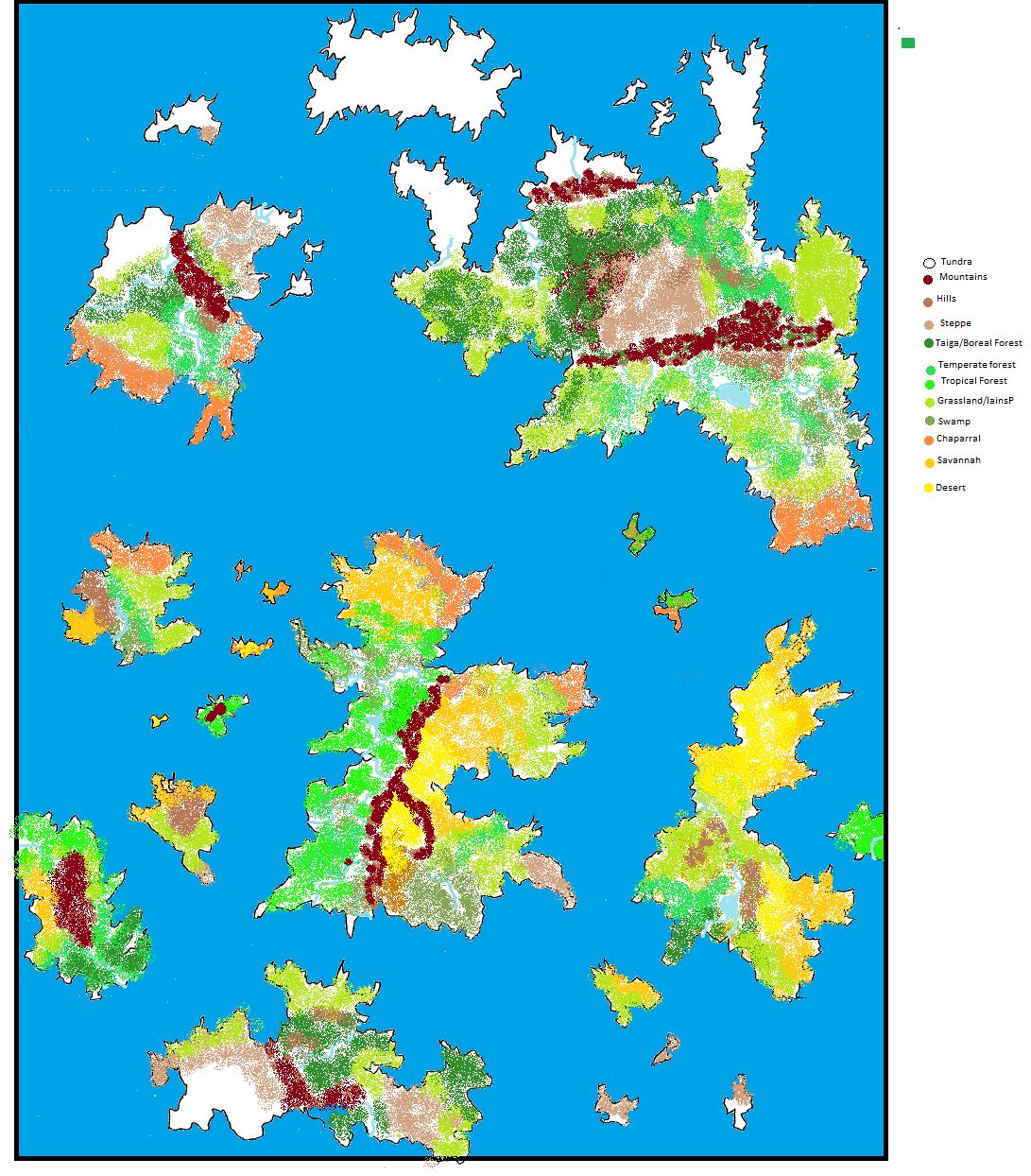 Now, I was told in the chat thread that the position of the mountains doesn't really work, because they are supposed to follow along the shape of the continent and not cut it in half. Effectronica was nice enough to make me an enlarged version with optimal mountain position, but I would like to get some more opinions before placing all those biomes again. 
|
|
#
?
Jun 1, 2015 19:35
|
|


|
As a geology grad, thumbs up for Effectronica's advice. To add my two cents, the layout makes me think there must be a deep volcanic trench between the northern and southern continents, so maybe the continents are slowly moving north and south (like a few centimeters a year). Also you could put some volcanic mountains on those islands if you wanted, sort of like Japan or Hawaii.
|
|
#
?
Jun 1, 2015 21:03
|
|


|
paradoxGentleman posted:Hello map thread, do you also accept unofficial maps? Because I have a lovely homemade map that I'd like to hear your opinion about : I'm pretty sure that's exactly what this thread is for. I agree with Effectronica's assessment about mountain ranges and such. The other thing you should look at is rivers and water ways. They always flow from high ground (your mountains) to the oceans in the most direct path possible. For pre-industrial civilizations rivers are the lifeblood of the world, they provide water and fertile land for crops and they provide the only method of quickly moving goods inland. Cities and towns build up around rivers and seaports and those are where cultures are born. As for software, I haven't used Campaign Cartographer or at least 10 years, but when I used it, it was very complex and very expensive, more tool than I would suggest for most people. There are plenty of free alternatives to Photoshop that give you much more flexibility than MS Paint. GIMP is always an option, but something like Paint.net might be better for a casual user.
|
|
#
?
Jun 1, 2015 21:09
|
|
|
CC's been pretty reasonably priced for years. Just checking now, it's $45 for the base software. It comes with a lot of stuff and has become quite a bit user friendlier over the years, and there are a lot of tutorials available now. It comes with a lot of templates at base, but if you want to buy the big pre-made content packages the price jacks up pretty quickly. I would advise pG against buying it right off the bat, though. Definitely experiment with cheaper options, and be absolutely sure you want to shell out ~$50 to $200 on CC before you dive in there. Check out the demo and some tutorials, maybe. (ProFantasy makes Campaign Cartographer.) Amusingly, the image on their front page is very clearly a Fenlon MERP-style map. That Old Tree fucked around with this message at 21:38 on Jun 1, 2015 |
|
#
?
Jun 1, 2015 21:35
|
|


Bucnasti posted:I'm pretty sure that's exactly what this thread is for. The only thing that Paint.net really needs to be ideal IMO is a couple more curves in its line tool, but it's really handy to have.
|
|
|
#
?
Jun 1, 2015 21:41
|
|
|
thank you. Weirdo posted:As a geology grad, thumbs up for Effectronica's advice. To add my two cents, the layout makes me think there must be a deep volcanic trench between the northern and southern continents, so maybe the continents are slowly moving north and south (like a few centimeters a year). Also you could put some volcanic mountains on those islands if you wanted, sort of like Japan or Hawaii. Are you referring to the islands west of the central continent? Because I love the idea of them Being volcanic. As for the volcanic trench, I have a question: what exactly does that mean for the stretch of sea between those regions? Underwater volcanic activity? That might be a good place to have an underwater civilization, since it given them access to Bucnasti posted:I'm pretty sure that's exactly what this thread is for. I did try to do that with my rivers on my first try, but I allowed myself a bit of liberty because I noticed that Earth rivers do seem to meander a bit. I guess that accounts for different heights on the plain and small hills. I also think that not all of my civilizations will be pre-industrial, but this is something that can wait until I have the physical map of the world down. I will check that site tomorrow, as I am on mobile now and can't properly See how it is.
|
|
#
?
Jun 1, 2015 21:50
|
|
|
paradoxGentleman posted:As for the volcanic trench, I have a question: what exactly does that mean for the stretch of sea between those regions? Underwater volcanic activity? That might be a good place to have an underwater civilization, since it given them access to Basically there is a long division between undersea tectonic plates where new magma rises up, pushing existing rock outwards, and in turn pushing the continents away (like comparing North America and Europe), so there is plenty of underwater volcanic activity. I'd expect the ocean to be fairly deep between the north and south continents, compared to similar northern and southern continents. Also island adventures and volcanoes go hand in hand 
|
|
#
?
Jun 1, 2015 22:54
|
|
|
That was supposed to be' "gives them access to smelting". Sorry about that.
|
|
#
?
Jun 1, 2015 23:18
|
|
|
Pretty minor, but I wanted to clue anyone in who might benefit from it. I found 1" diameter and 2" diameter wooden disks for about a buck at Hobby Lobby with their unpainted wooden crap. I would have gone to a store that didn't hate women but the convenience and the fact that I paid in change will have to be my only mitigation. They're superb "random dude" tokens.
|
|
#
?
Jun 2, 2015 23:54
|
|

|
When you put biomes on that map, remember to note where your prevailing winds are in that latitude. Generally you'll have equatorial forests, then a band of desert on either side, and rain shadows will create wet areas on the windward side of mountains (rivers will form here) and dry areas on the leeward side. There can definitely be exceptions to these rules, and I find it fun to put some weird places in and come up with magical or mythological explanations as to why they break expectations.
|
|
#
?
Jun 3, 2015 07:06
|
|

|
Lemniscate Blue posted:When you put biomes on that map, remember to note where your prevailing winds are in that latitude. Generally you'll have equatorial forests, then a band of desert on either side, and rain shadows will create wet areas on the windward side of mountains (rivers will form here) and dry areas on the leeward side. In the first version of this map, I had actually a separate map for water currents and winds, exactly to keep track of these sort of things. I am now remaking it using Paint.net As nice as Campaing Cartographer looks, I don't like the idea of dropping 50$ for something with such a niche utility, especially if I can obtain a decent result using a free program. e: Which leads me to another question: what happens when two water currents move one against the other, when they clash? Whirlpools? Bad weather zone? It just doesn't happen in nature? paradoxGentleman fucked around with this message at 23:21 on Jun 3, 2015 |
|
#
?
Jun 3, 2015 23:06
|
|
|
Whirlpools only really happen in narrow confines (straits and the like). Large, standing open ocean whirlpools are pure mythology.
|
|
#
?
Jun 6, 2015 04:24
|
|


|
This is a bit more abstract than most, but I'm curious if there's a right way to simulate planet or moon swelling and cracking within from the sudden release of a great amount of semi-solid liquid into the planet's core from a pocket dimension.
|
|
#
?
Jun 8, 2015 05:27
|
|

Father Wendigo posted:This is a bit more abstract than most, but I'm curious if there's a right way to simulate planet or moon swelling and cracking within from the sudden release of a great amount of semi-solid liquid into the planet's core from a pocket dimension. what kind of liquid?
|
|
|
#
?
Jun 8, 2015 05:30
|
|
|
Effectronica posted:what kind of liquid? Something fictional, like a shoggoth or the slime from Ghostbusters 2. I know how dumb that sounds and I should probably wing it, but I figure it's worth a shot. Looking back, 'stupid' was probably more accurate than 'abstract.'
|
|
#
?
Jun 8, 2015 06:03
|
|
Father Wendigo posted:Something fictional, like a shoggoth or the slime from Ghostbusters 2. I know how dumb that sounds and I should probably wing it, but I figure it's worth a shot. Well, what kind of temperatures and pressures can it handle? If it would stay a liquid under essentially arbitrary conditions, then you'd have at the end an overall bulging based on the total volume applied as a thick shell, and in the interim, devastation as the crust is raised and lowered as the liquid evens out. Cracking the planet would then require enough liquid to increase surface area beyond the ability of plate tectonics to handle. Actually destroying a planet by scattering wouldn't be possible with such means, though I'm afraid the rest will have to wait.
|
|
|
#
?
Jun 8, 2015 13:50
|
|
|
I need some map-related help. Unfortunately, I don't yet have a picture to show, so I'll have to describe with words. Mostly, I need help deciding which way rivers would flow. The continent I'm working on has a mountain range running north-south in the middle-western part that's creating a rain shadow to its east, leading to a fairly large desert in the center of the continent. Obviously, most of the water is going to end up on the western side of the mountains, because that's where the rain's coming from, so most of the rivers should be flowing westward. Would there ever be an eastward-flowing river from a setup like that? Basically, I'm trying to find a way to have a city on the southeastern edge of the desert with some sort of water source that I don't have to handwave with magic.
|
|
#
?
Jun 12, 2015 16:21
|
|

|
paradoxGentleman posted:e: Which leads me to another question: what happens when two water currents move one against the other, when they clash? Whirlpools? Bad weather zone? It just doesn't happen in nature? To vastly oversimplify... Ocean currents mostly circulate warm water from the equator to the poles and cold water from the poles to the equator. They tend to work in big circles, and often (not always) skirt coasts. Coastal areas near a cool current will be cooler than you'd expect, coastal areas near a warm current will be warmer than you'd expect. Areas where cool and warm currents meet tend to get more storms and fogs than other places. Earth's currents look like this.  They don't really "clash" so much as kind of flow around each other in a really really big swirl. You're not going to get whirlpools because of it. Whirlpools form on a much much smaller scale. There are some frighteningly large ones that reliably happen in certain places, but they have noth8ing to do with large-scale ocean currents: https://en.wikipedia.org/wiki/Maelstrom Elector_Nerdlingen fucked around with this message at 17:21 on Jun 12, 2015 |
|
#
?
Jun 12, 2015 17:08
|
|


Harrow posted:I need some map-related help. Unfortunately, I don't yet have a picture to show, so I'll have to describe with words. Yes. Rivers and lakes can also be fed by groundwater and aquifers, and if the mountains are high enough for snow, snowmelt will also feed streams. The Colorado River is largely fed from these sources, for example. So a little detail about rivers:  This is a map of the major watersheds of the continental United States. Watersheds are areas of common drainage. You can see that North America is dominated by the Mississippi's watersheds, with the Rio Grande, Colorado, and Columbia also being important, in terms of rivers. You can also see the outlines of the Appalachians and Rockies in rough form. The areas that aren't dominated by a river are divided into three types. The Great Lakes come together in the Saint Lawrence eventually, but the majority of the drainage consists of small rivers and lakes that converge on the Great Lakes before heading out to sea. California, New England, the Mid-Atlantic, and the South-Atlantic Gulf all have a series of small rivers that run more or less directly to the ocean. The Great Basin, meanwhile, is an area between the Rockies and Sierra Nevada, which is an endorheic basin- one with no external drainage. All water in the Great Basin (mostly from snowfall in the mountains) either evaporates or fills an internal lake, of which the Great Basin has two major ones (the Great Salt Lake and Lake Tahoe). So you have several different ways in which this can work.
|
|
|
#
?
Jun 12, 2015 18:40
|
|
|
I made some progress on the map and would like to hear your opinions: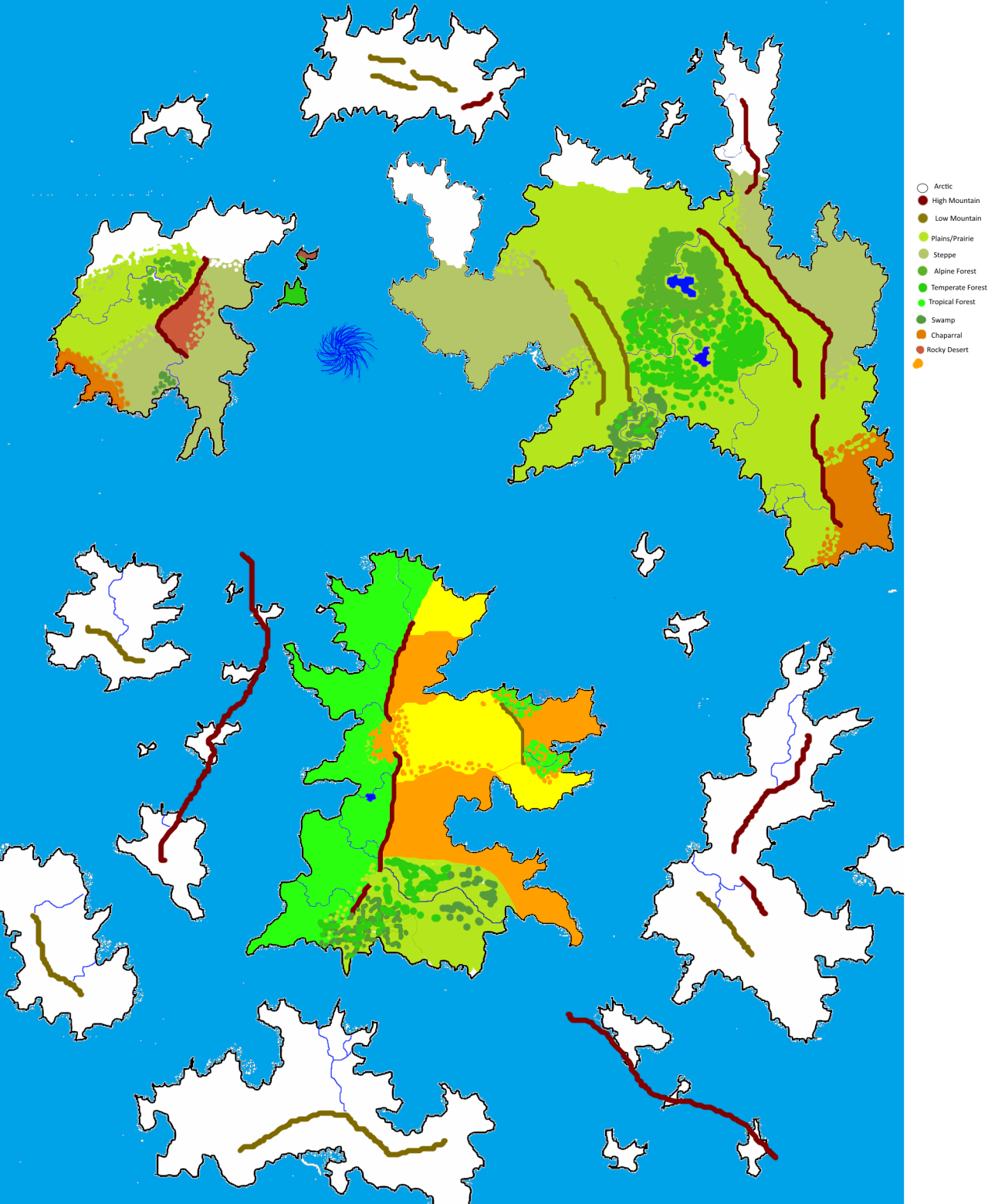 The whirlpool between the two northern continents is caused by a giant slug/mussel hybrid that lives at the bottom of the ocean and slowly crawls around devouring fish in its wake. Sorry Zorai, I saw "giant ocean whirlpool" and "mythology" together and my imagination went wild. Its WIP name is Salt's Maw. That being said I still have a couple of questions: -Does the rocky desert I placed on the north-western continent make sense? I figured that since it was not only on the rain shadow, but that whatever winds could have brought rain to that zone would have been absobed by the whirlpool, which means no erosion, which could allow such a biome to exist, but I am not sure. -What about the swamps? I have a fondness for swamps, and I feel I might have gone overboard with them. I don't honestly know where to place them if not near rivers. That's what comes to mind, but if I messed up anything else please let me know. e: I just realized I forgot to complete the legend. The orange you see in the central continent is supposed to be savannah, and the yellow desert.
|
|
#
?
Jun 14, 2015 14:34
|
|
|
Probably off-base here, but reverse your desert and savannah patches, so that the deserts are by the mountains, and the savannahs at the gaps?
|
|
#
?
Jun 14, 2015 14:43
|
|
|
Terribly sorry, I messed up something else on the map and figured I should just patch it up:Angrymog posted:Probably off-base here, but reverse your desert and savannah patches, so that the deserts are by the mountains, and the savannahs at the gaps? The idea is that since that zone is sandwiched between two mountain ranges, it's hard for the rain-bringing winds to reach it, so it's extremely dry there.
|
|
#
?
Jun 14, 2015 14:59
|
|
|
http://www-cs-students.stanford.edu/~amitp/game-programming/polygon-map-generation/demo.html This is pretty neat. It randomly generates a continent for you, which you can also look at in 3D. Plenty of viewing options and other things to play around with.
|
|
#
?
Jun 17, 2015 15:41
|
|

|

|
| # ? Apr 30, 2024 15:41 |
|
|
Finally gonna run my noir game set in 1980 Moscow. The trouble: I've got only one corkboard. Should I rather: - Stick a city map on it, so that we can insert labeled pins for all sorts of murder/suspect locations players encounter along the way. - Keep it plain, prepare some photos and a bunch of string, so the players can do a TV-style evidence board. We can grab a map and use it as a tablecloth-that-sometimes-is-a-useful-prop anyway. - Compromise solution: prepare photos and poo poo in a relatively small size so we can pin them to the map where needed. Would probably make trying to read actual street names a pain in the rear end, but whatever, it's just there to look good. I'm not sure I have a map old enough to have all the old soviet street names anyway. Assume no one else at the table has first-hand familiarity with the city, yet particular location details aren't very important (like, I could maybe drop a puzzle of "he couldn't have crossed half the city in 10 minutes like he said" and that's it). Then again, it's loving noir, so thinking too hard about details of the mystery isn't the point either. It's pretty much all about what will look most cool and will better set the mood.
|
|
#
?
Jun 22, 2015 12:55
|
|