|
Ahh, pretty. Very pretty. You've entertained my for the night. But not quite. Looks like your missing a lane both directions too. A branch merge juction splits every lane to go to every other lane in every direction. I think.
|
 #
?
Feb 20, 2010 02:44
#
?
Feb 20, 2010 02:44
|
|


|

|
| # ? May 11, 2024 11:25 |
|
|
M_Gargantua posted:Ahh, pretty. Very pretty. You've entertained my for the night. Imagine there are slip roads just off the diagram, positioned far enough back to avoid excessive weaving. I'm limited to 600px, otherwise I'd have included them.
|
|
#
?
Feb 20, 2010 03:53
|
|


|
This is the only rail bridge over rt1 in Branford I see, is it the one you're referring to that needs to be replaced? http://maps.google.com/maps?q=branf...2,220.6,,0,3.73
|
|
#
?
Feb 22, 2010 20:05
|
|


|
GWBBQ posted:This is the only rail bridge over rt1 in Branford I see, is it the one you're referring to that needs to be replaced? Yep, that's it. Note that Route 1 can only fit 2 lanes under there, with low clearance. The track itself is being raised for the new bridge, so that's a large part of the cost. And for you, M_Gargantua... after playing a lot of OpenTTD, I took another crack at your gigantic interchange. The result would work for trains just as well as cars. It can easily handle 4 million entering vehicles per day (10X as much as the busiest highway in the world) with zero weaving, and fits conveniently into a square a mile to a side! I built 1/4 of it in VISSIM. The other three approaches are identical, just at different elevations. VISSIM doesn't have copy/paste, and I value my wrist integrity. Just imagine the other three stacked on top of this; the yellow roads are their beginnings and ends. With this setup, there are, in some places, 9 roadways stacked on top of one another.      So yeah, you owe me like... 60 blowjobs now.
|
|
#
?
Feb 22, 2010 22:48
|
|
|
Cichlidae posted:And for you, M_Gargantua... after playing a lot of OpenTTD, I took another crack at your gigantic interchange. The result would work for trains just as well as cars. It can easily handle 4 million entering vehicles per day (10X as much as the busiest highway in the world) with zero weaving, and fits conveniently into a square a mile to a side! Now who's to say video games haven't brought us anything good. 60 BJ's are alot. Can I hire strippers to do the work for me?
|
|
#
?
Feb 23, 2010 00:01
|
|
|
M_Gargantua posted:Now who's to say video games haven't brought us anything good. Subcontracting is ok, as long as you meet the minimum 10% disadvantaged business enterprise quota.
|
|
#
?
Feb 23, 2010 01:19
|
|
|
Are the traffic cameras in CT really that awful or are we getting sized down versions on the web? 254x204 is like thumbnail size, and you can't even tell if the roads are clear or slushy.
|
|
#
?
Feb 26, 2010 15:18
|
|

|
Cichlidae posted:At first, I thought that was an innuendo. Then I looked it up. Daaaaaaaamn. Sweet jesus, I thought I had built some crazy poo poo in TTD.
|
|
#
?
Feb 26, 2010 16:20
|
|
|
smackfu posted:Are the traffic cameras in CT really that awful or are we getting sized down versions on the web? 254x204 is like thumbnail size, and you can't even tell if the roads are clear or slushy. The feeds in the TOC are much better. If it's anything like Rhode Island's, the quality isn't great (you try streaming MPEG-1 over a shared cable line), but it's at least TV-worthy. The cams on T1 and fiber are very clear and responsive. However, putting them on the web is expensive. Most states only do still images with an occasional refresh. You can imagine how much bandwidth is required for video, and hopefully that'll tell you why the web versions are so small. BklynBruzer posted:Sweet jesus, I thought I had built some crazy poo poo in TTD. At the risk of turning this into OpenTTD Megathread, I haven't seen the need for any interchanges in my city. All of my trains are on dedicated lines for a single resource, double-tracked. Is there really an advantage to having quad-tracked lines running all kinds of cars? Traffic News Remember how the new MUTCD mandates mile-based exit numbering? It's now my job to go through and see what the new exit numbers would be if we switched over. Things don't look good. On CT 2 in East Hartford, for example, we've got something like 6 exits that should have an Exit 1 designation. On I-84 in Southington, the exits for I-691 and CT 322 sort of overlap, so exit numbers will be out of order no matter what. Granted, it's a change for the better overall, but it's going to be intensely complicated and expensive. A quick back-of-the-napkin estimate put it at around $100 million to change our exit numbers, and that's not including lawsuits from all the businesses that we'll piss off. Edit: Spent all afternoon on this. It's nuts. There are 3 exits in Waterbury within 0.15 miles. There are unnumbered exits on Routes 2, 3, 6, 7, 8, and 9, and I've only gotten up to 15 so far. No matter how I number these things, there will always be cases when the exits are in the wrong order. Very challenging... and I have to have it all done for Wednesday morning. Cichlidae fucked around with this message at 23:09 on Feb 26, 2010 |
|
#
?
Feb 26, 2010 18:18
|
|
|
Cichlidae posted:At the risk of turning this into OpenTTD Megathread, I haven't seen the need for any interchanges in my city. All of my trains are on dedicated lines for a single resource, double-tracked. Is there really an advantage to having quad-tracked lines running all kinds of cars? Chicks dig huge mainlines  Without derailing too much, whenever I play OpenTTD I'll have a massive network of low-level industries feeding a single mid or high level industry, and separate that out onto its own dedicated two-point network with extremely high volume but no actual intersections.
|
|
#
?
Feb 26, 2010 23:40
|
|


|
Cichlidae posted:The feeds in the TOC are much better. If it's anything like Rhode Island's, the quality isn't great (you try streaming MPEG-1 over a shared cable line), but it's at least TV-worthy. The cams on T1 and fiber are very clear and responsive. However, putting them on the web is expensive. Most states only do still images with an occasional refresh. You can imagine how much bandwidth is required for video, and hopefully that'll tell you why the web versions are so small. Welcome to the world of exits 1A-F! ")
|
|
#
?
Mar 2, 2010 20:04
|
|

|
Cichlidae posted:Granted, it's a change for the better overall, but it's going to be intensely complicated and expensive. A quick back-of-the-napkin estimate put it at around $100 million to change our exit numbers, and that's not including lawsuits from all the businesses that we'll piss off. Do you know how much it cost other states to do this? I remember Florida switching over all the interstates to mile-based exits starting in 2000 or so, and California's been adding exit numbers to a few thousand miles of freeways. It took Florida 3-4 years to get everything done, so the cost would be spread out somewhat, but that's still a pretty huge expense.
|
|
#
?
Mar 2, 2010 21:04
|
|

|
kefkafloyd posted:Welcome to the world of exits 1A-F! Yep, that's I-91 in New Haven. I finally finished all the numbering, and the result is a 16-page spreadsheet. Here are a few oddities: Route 72 and I-691's exit numbers are backward. 72 is technically a north-south route beginning at Route 9, and 691 technically begins at I-91. We'll have to flip their exit numbers around. I-691 becomes CT 66 as it crosses over I-91, so the same exit for 91 is technically on two routes. Luckily, they both begin there, so the mileage is the same (0). Unluckily, my bosses don't want any exit 0, so it'll be 1A on 66, and 691's exits will begin with 1B. 91, as mentioned, gets exits 1A-1F in New Haven. It also gets 38 A-E in Hartford. At least I made small improvements where I could! Things make a bit more sense now statewide. I put exit numbers at each freeway that terminates at another. The only routes I can currently find that have that are 9 at 84 and 691 at 84. Of course, things get a little weird with routes like 8 and 40 that end at an interchange with surface streets. There is no standard for what has exit numbers and what doesn't. Route 20 has 6 exits, 8 if you count 401. No numbers. Route 695 has one numbered exit, as does Route 40. There are plenty of exits that are out-of-order. Going southbound on US 7 in Brookfield gets you exits 12, then 11, then 13. Closely spaced? Hell no, they're miles apart. How did this happen? South of Danbury, it drops the exit numbers altogether, and picks them back up in Norwalk. Back in the early 1990s, Route 20's terminus at I-91 was upgraded from a trumpet to a directional T. It resulted in adjacent exits 39 and 41 being cut in half, from eight ramps to four. Despite the fact that there's only one off-ramp in each direction, the ramps are each signed for both exits... two miles apart. Dominus Vobiscum posted:Do you know how much it cost other states to do this? I remember Florida switching over all the interstates to mile-based exits starting in 2000 or so, and California's been adding exit numbers to a few thousand miles of freeways. It took Florida 3-4 years to get everything done, so the cost would be spread out somewhat, but that's still a pretty huge expense. I have no idea, and I don't even know very well how much it will cost us. It's difficult to separate the costs of changing exit numbers with the costs of sign replacement that we'd have to do anyway, and then we've got the issue of the bigger exit crowns in the new MUTCD (30" vs 24" currently used), which is going to require new Vertical Attachment Members on all of our sign supports, and that means taking things apart and re-welding, and sometimes replacing the whole support if the extra square footage will bring it over its rated load...
|
|
#
?
Mar 2, 2010 22:56
|
|
|
Arizona seems to be adopting the new MUTCD quickly. They just resigned / restriped a section of US60W between Loop 101 and I10 in Tempe as part of a widening project, and the new signage is loving huge. Also, they drastically extended the exit-only lane for the one-lane ramp from 60W to 10E, so now it's nearly a mile long instead of about 200 yards.
|
|
#
?
Mar 2, 2010 23:15
|
|
|
I live in Ottawa which is fairly recently adding roundabouts (our first two-lane opened just a few months ago). In general the roads they're put on are either residential or just low traffic in an effort to ease people into it. There's one four way roundabout that has actually been around for a while, and I've only recently noticed something alarmingly wrong with it. 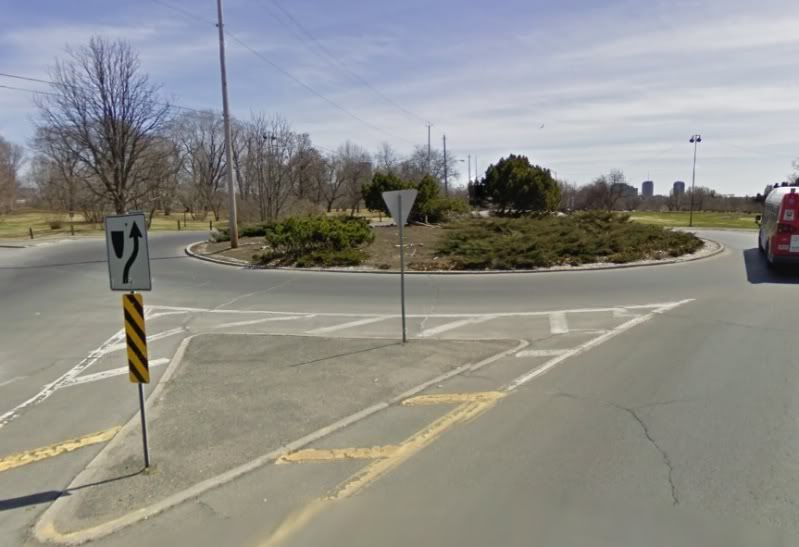 You may notice that the yield sign faces inwards. I assure you this isn't the work of vandals, they really want you to yield to traffic trying to get in. Now this one is relatively low traffic even during rush hour, but it's positioned near several tourist attractions and a university. If traffic ever started to build here (and assuming people obeyed the signs exactly) then you could end up with people unable to enter, and unable to move ahead enough to get to their exit. Presumably this could be solved on the fly if people near the exits jumped out to allow things to move again, but I can tell you nobody would clue in until the traffic has built up immensely in all directions. Why did they set the signs that way? None of the others around here, or any that I've seen, are like that!
|
|
#
?
Mar 3, 2010 04:03
|
|

|
Through The Decade posted:I live in Ottawa which is fairly recently adding roundabouts (our first two-lane opened just a few months ago). In general the roads they're put on are either residential or just low traffic in an effort to ease people into it. Yeah, that's completely nonstandard. Roundabouts are meant to give priority to circulating traffic. Someone must have made a mistake. The contractor may have misread the plans, or the traffic engineer had no idea how roundabouts work. I'd contact someone if I were you, because you're right, it could gridlock very easily if a slug of cars came by.
|
|
#
?
Mar 3, 2010 04:28
|
|
|
Hye you got any advice to fix this fuckup (12th ave and 99): http://maps.google.com/maps?client=...021114&t=k&z=16 This interchange is basically completely useless between the hours of 7-9am and 4-6pm. So what we have is this: High traffic coming from neighborhoods on both sides all heading north on 99( the freeway). There is also heavy traffic at the same times going in reverse. However, almost no traffic is coming from or wants to go south. There is virtually no traffic going between the neighborhoods on either side of the freeway. Fairly heavy truck traffic from freeway going east on 12th to the Bakery next to the freeway. Traffic from the west bill backup to the bridge over the railway at 3 or 4 PM and will backup to freeport ave later. Traffic will back up on 99 South all the way to the interchange with biz-80/50 Intersections blocked and locked. There is a ramp semaphore at the end of the ramp from 12th ave on to 99N. They're going to add 250,000sq feet of retail and 500 units of residential in that brownfield to the west next to the railway. Alternative N/S routes freeport and franklin are also at capacity and land value around them is high enough nothing will ever get done. No one will cry if you take at least some of the lovely strip mall to the west, however, the Mormon temple north of it is probably off limits. Noise would be a concern. Similarly, you could probably take a lot or two to from the northeast. That neighborhood sucks. The either areas is currently rated an "F" for traffic volume and the developer isn't being forced to do anything because the development won't lower the rating (because the scale doesn't go beyond F). Also, we're loving broke.
|
|
#
?
Mar 3, 2010 08:20
|
|

|
nm posted:Hye you got any advice to fix this fuckup (12th ave and 99): Well, this looks like as good a spot as any for a SP-  GODDAMN IT, ROUNDABOUT MAN!  As I was saying, a SPUI would work pretty well here. It needs a wider bridge and maybe some extra ROW, but nothing terribly extensive. The ramp metering should prefent the freeway from getting clogged. Widening the road should allow for some more turn lanes, too, and shorter cycles, which lowers queues.
|
|
#
?
Mar 3, 2010 18:26
|
|
|
I like the roundabout idea and will forward it to the city.
|
|
#
?
Mar 4, 2010 01:39
|
|
|
Hey there Cichlidae, I'm studying mechanical engineering, but I've taken several courses on infrastructure, and what do you think about light rail integration onto medium highways (3-4 lanes), as a way to reduce congestion, when combined with park and ride? With the terrible nature of drivers, would it lead to plenty of wrecked cars, or should it be the new wave of the future. I'm in New Jersey, land of the heavy rail, and horrid traffic density (gently caress this intersection for being constantly full at peak hours, when driving is hell
|
|
#
?
Mar 4, 2010 01:52
|
|

|
Ryand-Smith posted:Hey there Cichlidae, I'm studying mechanical engineering, but I've taken several courses on infrastructure, and what do you think about light rail integration onto medium highways (3-4 lanes), as a way to reduce congestion, when combined with park and ride? With the terrible nature of drivers, would it lead to plenty of wrecked cars, or should it be the new wave of the future. It's a great idea if you have the width. As long as there's some good barrier, collisions aren't a danger, and the fact that freeways are already grade-separated makes it an economical choice. Overpasses could be fitted with platforms going down to the train tracks for easy access. Park and ride lots between the tracks or nearby would increase the station's effective range even more, especially if they can be accessed directly from the freeway. nm posted:I like the roundabout idea and will forward it to the city. Roundabout Man offers them his most sincere greetings.
|
|
#
?
Mar 4, 2010 03:22
|
|
|
One last question for now, how does your state deal with grade crossings, do you have an active policy against them? And how do you personally feel about grade crossings.
|
|
#
?
Mar 4, 2010 06:11
|
|
|
Cichlidae posted:It's a great idea if you have the width. As long as there's some good barrier, collisions aren't a danger, and the fact that freeways are already grade-separated makes it an economical choice. Overpasses could be fitted with platforms going down to the train tracks for easy access. Park and ride lots between the tracks or nearby would increase the station's effective range even more, especially if they can be accessed directly from the freeway. Are there some case studies of freeway lanes being taken out for this kind of light rail? When I went to Boston last month, I stayed on the newish T Silver Line. I think the MBTA tried to push it as just another light rail line but it's actually a bus rapid transit route that is sometimes in purpose-built tunnels and sometimes shares the road with normal traffic. The locals seemed very underwhelmed with the Silver Line, and I have to admit that I was more optimistic about BRT before I actually tried it. Have you tried it? The Wikipedia page has some interesting criticisms.
|
|
#
?
Mar 4, 2010 06:55
|
|

|
Ryand-Smith posted:One last question for now, how does your state deal with grade crossings, do you have an active policy against them? And how do you personally feel about grade crossings. They're very dangerous, cumbersome, and lower our train speeds. We even have stop-and-protect crossings here, where the train has to stop completely, get someone to stand on the road and stop cars, and then drive through. We try to eliminate grade crossings where possible, but we can only afford to do maybe one a year, and some towns have dozens. Mostly, we just put up crossing gates with flashing lights. That's much cheaper, though not quite as good as a grade-separated crossing. Mandalay posted:Are there some case studies of freeway lanes being taken out for this kind of light rail? I believe someone posted earlier in this thread about one in Washington state. I believe I've also seen them near Los Angeles. I'm told there used to be many more, but they were paved over decades ago to add more capacity to the freeway. As to the Silver Line, yes, I've ridden it, back when one of the tunnels was closed due to falling ceiling tiles. The buses were taking a different route than they do now, so I'm not sure if it's fair to make a full assessment. I agree with the criticism, though. For the cost, a rail line would have been much better. I disagree with many of the MBTA's decisions; they've done a terrible job of management in the past, and it seems almost na�f to hope for that to change now that they've reorganized.
|
|
#
?
Mar 4, 2010 13:16
|
|
|
The area where I live has 2 train tracks (owned by 2 different companies) that become parallel from different directions. There's also a merge somewhere so only one can proceed if two are there. http://maps.google.com/?ie=UTF8&hq=&ll=40.186906,-85.406556&spn=0.008967,0.017188&t=h&z=16 This is chaos. The train that comes southwest seems to always get priority. That means the train that comes from the northwest has to stop on the tracks. If you move the map to the west a bit you'll see Tillotsin Ave, which is a major 4-lane street. Yes, it gets blocked. Frequently. There have been a ton of newspaper columns about the huge problem this causes (especially for the hospital, since the tracks essentially the cut the city in half). Comedy fact: Sometimes the train coming from the NW stops in front of the Tillotsin Ave crossing and goes to McDonalds  You'll also see that the train also goes downtown  Grade crossings suck 
|
|
#
?
Mar 4, 2010 16:08
|
|

|
ijustam posted:This is chaos. Ah but you didn't mention all the lovely 5 way stops! I swear to god I think I'm going to get a middle finger cramp from how many times people just kinda cruise through the Bethel / New York intersection.
|
|
#
?
Mar 4, 2010 16:16
|
|

|
Cichlidae posted:I was in Malm� this weekend and got a bad surprise: They've built roundabouts on the motorways. Combine that with really bad signage and you've got a road system impossible to navigate.
|
|
#
?
Mar 8, 2010 08:38
|
|


|
nielsm posted:I was in Malm� this weekend and got a bad surprise: They've built roundabouts on the motorways. Combine that with really bad signage and you've got a road system impossible to navigate. From the satellite photo, it seems that the roundabouts are only at the end of the expressway, and then it transitions to at-grade intersections. Putting them between two high-speed sections would be silly, but using them to transition between high-speed and low-speed sections is a proven technique that reduces velocitizing. Bad signage, on the other hand, is never good!
|
|
#
?
Mar 8, 2010 13:10
|
|
|
Cichlidae posted:expressway 
|
|
#
?
Mar 8, 2010 14:30
|
|
|
Is there a reason that for short tunnels (like on an on-ramp or off-ramp that travels under another freeway or something) they line both sides with tons and tons of lights spaced probably a foot apart but only have every 10th on turned on?
|
|
#
?
Mar 8, 2010 15:16
|
|

|
nielsm posted:I was in Malm� this weekend and got a bad surprise: They've built roundabouts on the motorways. Combine that with really bad signage and you've got a road system impossible to navigate. I haven't used it that often but it's been there for almost 40 years and it seems to work okay, except when it's busy. It gets lots of traffic jams, although I can't know if there would be more or fewer traffic jams with a different intersection. They're going to replace it with an interchange and an exit next year: http://www.knooppuntjoure.nl/download.asp?link=files/28445/%5B01%5Dintegrale_visie_luchtfoto.pdf&objectID=28445 Makes sense to split it like that to me, too bad about that well-known and historic roundabout disappearing though The signs on it are fine, but the situation is not as complicated - one road into the city and three highways, and most traffic will only be going east-west or west-east anyway. edit: And yes, those are regular old high speed 120 km/h highways there, although there's a speed limit of 50 km/h on the roundabout itself and the section of highway going up to it. Entropist fucked around with this message at 15:47 on Mar 8, 2010 |
|
#
?
Mar 8, 2010 15:45
|
|
|
Socket Ryanist posted:Freeway. What, you're going to call me out on that but not mention the casual use of 'velocitizing'? Frinkahedron posted:Is there a reason that for short tunnels (like on an on-ramp or off-ramp that travels under another freeway or something) they line both sides with tons and tons of lights spaced probably a foot apart but only have every 10th on turned on? Fixing burnt-out lights in tunnels is a huge pain in the rear end. You need to close a lane, provide tapers, use a few hundred square feet of signs, and get state troopers out there to keep traffic moving. Therefore, we try to do it as rarely as possible. In your case, it could be that 9/10 have burnt out, but it's more likely that different sets are on different circuits so, when enough of one set burn out, they can just turn on the next. Entropist posted:We have one of those too around here: http://maps.google.com/?ie=UTF8&ll=...077162&t=h&z=14 (there's street view too). Worth noting that that's not a roundabout; it's far too large. It does use a turbo roundabout configuration, though, which is awesome. I know, if we tried something like that here, there'd be miles-long backups from confusion. From the pavement width and lane markings, it looks like it used to be a three-lane or two-lane circle with wide The proposed reconfiguration is a little weird; it doesn't maintain route continuity on A7, since you'll need to take a right turn to stay on the route. Capacity-wise, it looks like it could handle a lot more than a traffic circle. Edit for word use Cichlidae fucked around with this message at 22:40 on Mar 8, 2010 |
|
#
?
Mar 8, 2010 18:24
|
|
|
I had a closer look at the signs in Street View, thinking you were right, but it clearly has the blue roundabout sign with circular arrows, so it is one officially. Big circles like these are often classified as circular one-way roads, with one-way road signs, but not this one. Ten years ago they changed it from a 2 lane roundabout to a turbo roundabout with bypasses. It used to work like a regular multi-lane roundabout, where you'd take the inside lane if you had to go at least half of the way around, and otherwise the outside lane (but everyone would probably just stay in the outside one anyway). And I guess it had some pretty tricky weaving, a two-lane highway coming into the two-lane roundabout, resulting in two lanes and an exit lane for the next exit. This may not be correct since it was so long ago, but I think it had two lanes, and short on/off lanes between each exit. edit: I think this is the pre-turbo roundabout configuration:  Lack of route continuity probably won't be an issue, it's pretty common around here. I can think of many examples where the bulk of the traffic has to take the exit, and it continues into some unimportant highway or provincial road. Anyone who does a decent amount of highway driving has accidentally driven into Germany at some point, there are various options for this http://maps.google.com/?ie=UTF8&t=h&ll=52.693032,5.773659&spn=0.073557,0.154324&z=13 to follow the A6, one of the two main ways to the north of the country. http://maps.google.com/?ie=UTF8&t=h&ll=52.707231,6.456957&spn=0.036767,0.077162&z=14 Or this one in the A28, the other main way north. That highway going east to Germany wasn't even a highway until a few years ago. Entropist fucked around with this message at 19:28 on Mar 8, 2010 |
|
#
?
Mar 8, 2010 19:25
|
|
|
Do you have any ridiculously low clearance bridges on your state highways? I know TXDot used to have a list of low-clearance bridges and I remember one on the old highway paralleling IH-37 to Corpus Christi was like 10ft something and I remember the old Highway 71 underpass in Columbus had a 9ft clearance.
|
|
#
?
Mar 9, 2010 05:14
|
|
|
Also for Houston goons, as soon as they are done repaving the North Loop; guess what the next repaving project is. Southwest Freeway between Westpark and Bissonet
|
|
#
?
Mar 9, 2010 06:42
|
|
|
Getn Rod atAnimecon posted:Do you have any ridiculously low clearance bridges on your state highways? I know TXDot used to have a list of low-clearance bridges and I remember one on the old highway paralleling IH-37 to Corpus Christi was like 10ft something and I remember the old Highway 71 underpass in Columbus had a 9ft clearance. We have a few very low bridges, but not just on state routes. Nearly every bridge on I-95 in Connecticut is lower than interstate standards require. The average age of a bridge here is 50 years, and that's very nearly as old as the Interstate Highway System itself. We post height restrictions on most bridges, and sometimes have restrictions for the entire route. One of my projects is to remove a 12'-7" bridge (Route 10 over Route 322 in Southington) completely, because it's an impediment to the truckers who would otherwise use this road. I should note that a bridge's posted clearance is actually several inches lower than the actual clearance. We leave a buffer for road overlays, overinflated tires, and the like. I think it's 3", but I'm not sure if that's a local or national standard.
|
|
#
?
Mar 9, 2010 22:14
|
|
|
Cichlidae posted:We have a few very low bridges, but not just on state routes. Nearly every bridge on I-95 in Connecticut is lower than interstate standards require. The average age of a bridge here is 50 years, and that's very nearly as old as the Interstate Highway System itself. We post height restrictions on most bridges, and sometimes have restrictions for the entire route. You should put up one of these bad boys (Look straight up, bad lighting obscures the sign on other view) http://maps.google.com/?ie=UTF8&ll=...278.13,,0,-57.5 The sign says "IF YOU HIT THIS, YOU'LL HIT BRIDGE" It is effective. Also, peep this. http://maps.google.com/?ie=UTF8&t=h...359.986868&z=16 Ron Pauls Friend fucked around with this message at 05:11 on Mar 10, 2010 |
|
#
?
Mar 10, 2010 05:07
|
|
|
Southampton, NY has an even worse one http://maps.google.com/maps?f=q&sou....00142&t=h&z=20 It's not quite as narrow, but it doesn't help that there are blind corners before AND after the bridge. Head-on collision waiting to happen. Funny story: People got into the habit of honking their horns before they hit the blind corner. A guy who owns a house right there puts up a sign saying "DONT HONK", because, you know, his peace and quiet is more important than people not getting killed or maimed. After a few times of the city taking it down and him putting it back up, they threatened him with some huge fines, so he finally gave up.
|
|
#
?
Mar 10, 2010 12:07
|
|
|
Getn Rod atAnimecon posted:You should put up one of these bad boys (Look straight up, bad lighting obscures the sign on other view) http://maps.google.com/?ie=UTF8&ll=...278.13,,0,-57.5 We tried putting up a laser that would beep very loudly if a passing truck was too high. It worked too well. Within a week, the nearby residents had figured out what was causing the noise at 3 am and completely destroyed it. quote:Also, peep this. We're no stranger to those up here. This one is on CT 71 and 150, signalized: http://maps.google.com/maps?f=q&sou...,18.59,,0,11.02 SR 533 is named Tunnel Road. Here's why. This one is stop-controlled: http://maps.google.com/maps?f=q&sou...2,152.31,,0,9.8 We have plenty more in more rural areas. One is only wide enough for one lane, but doesn't even have stop signs, because of a similar curvature to what Socket Ryanist mentions above. In addition, it has roads on each side of the tunnel that run parallel to the tracks, so it's a completely blind 4-way intersection punctuated by a one-way tunnel.
|
|
#
?
Mar 10, 2010 13:14
|
|
|

|
| # ? May 11, 2024 11:25 |
|
|
Streetview just updated in the UK to cover almost every single road, so I can share that we have this in Jolly Old England as well! (since I can finally get street view in areas in familiar with) So you get it going under.. http://maps.google.com/maps?f=q&sou...356.94,,0,-3.59 But sometimes over as well! http://maps.google.com/maps?f=q&sou...356.94,,0,-3.59 Learning to drive in Winchester was quite a bitch, tiny roads and steep hills are bountiful (with a manual car as well!) For example, I had to come out of this junction on my driving test: http://maps.google.com/maps?hl=en&i...,228.39,,0,9.92 It was so loving nerve racking . Also here is Twyford Down curring, the main reason that motorway construction for the past 10 years has been so abysmal. (info Bonus: http://maps.google.com/maps?f=q&sou...2,52.28,,0,2.51
|
|
#
?
Mar 11, 2010 21:52
|
|