


|
Jalumibnkrayal posted:HTC 4G Android Phone (7 ounces) + charger (2 ounces) Smartphone Yes. Take it. I use mine for music, gps, camera and my book. I know a lot of people are like, I don't want music I'm going to commune with nature. But let me tell you, nature gets loving old and you want to jam out going up some hills. Google is handy for finding stuff in town. Keeping in touch with other hikers via facebook etc whenever you want is super nice. Facebook is like a central hiker register now days. You can get a lot of good info quickly by being in your classes Facebook group. Also, you can put all sorts of phones on Straight Talk plans now days if you don't want a contract. I kept my phone in my front shirt pocket with my headphones 100% of my hike. With it on airplane mode and no apps running, the battery drain is actually less than if you turn it on and off. I'd wake up in the morning, pack up and turn on my phone for the day. This leaves it accessible for quick pictures, checking my location, checking the time, or turning on some tunes. Kindle My girlfriend's kindle lost a fight with her bear can in the Sierras this year. Mine broke a month ago by tossing it onto the couch at home. I wouldn't carry one backpacking, they're kinda fragile and its another battery powered device you have to worry about. I do enjoy having a book on my phone. You can read a chapter in bed on your phone each night for hardly any battery. Camera Eh, I carry one, but I use my phone almost as much. I'm not sure if a camera will make it into my pack this spring. Still on the fence. I still use an old Canon A590 that takes AA's. One set of lithium will last me all summer. Solar Charger Don't bother. They're finicky and expensive for what you get. It won't replace your charger. Grab an extra battery or a battery pack. You don't always charge your phone in the motel or hostel. I've charged my phone at the supermarket, in a public restroom, at the bar, in a restaurant, convenience store etc etc. After awhile you start to get like a sixth sense for sniffing out those outlets. Everyone should attempt a thru hike. It will change how you think about life for the better
|
 #
?
Jan 6, 2013 05:14
#
?
Jan 6, 2013 05:14
|
|


|

|
| # ? May 21, 2024 14:30 |
|
|
Went to hike the Hualapai Mountains near Kingman, AZ this morning. Unfortunately I didn't have a pair of Yaktrax or Microspikes since I didn't plan on having time to go hiking on this trip. There was some awesome views but the trail was too icy for me to be comfortable continuing up once I got up to the 7000ft mark. Walking on solid ice with some pretty nasty drops nearby. The peak I was going for was at 8250.
|
|
#
?
Jan 6, 2013 23:49
|
|


|
http://www.everytrail.com/view_trip.php?trip_id=1971784 Did another hike in the local mountains today. Had a bit of a chuckle this time as the hike up into the canyon was extremely steep and slick. On my way up I ran into a guy coming down muttering, "brought the wrong shoes for this" who then proceeded to fall on his rear end and slide about 3 feet. Didn't hurt himself thankfully but god drat are some people unprepared and foolish enough not to turn around. In other news I used my new set of Yak Tracks on this trip and they worked like a champ. I slipped in a couple of spots but I never felt like my feet were going to kick out from under me. I did manage to get a couple of pictures this time and included them in the trip on Everytrail linked above. Without coming off too much like an advertisement, I really like using the Everytrail android app. It links the pictures to the location you took them from and allows other people to see hikes in areas that they may not be aware of. Also, if you're traveling somewhere it's great for finding hikes nearby without having to print off a bunch of pages or buy a local guide book.
|
|
#
?
Jan 6, 2013 23:54
|
|


|
My wife and I hiked Mount Starr King (3907') and Mount Waumbek (4006') in Jefferson, NH on Saturday (7.8 miles, 2900' elevation gain). High winds in the forecast kept us from picking a more exposed hike. Temps were in the low 20s, and it was breezy, but not too bad. There was a pretty good snowshoe track to follow. It was still a bit soft, so we wore our snowshoes most of the way. I loved the snow/ice encased trees up high.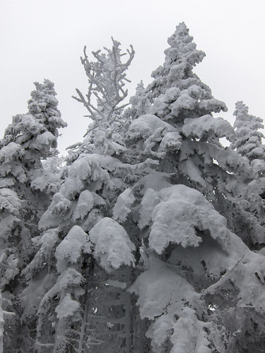 Snow encased trees by EPICAC, on Flickr  Starr King Trail by EPICAC, on Flickr 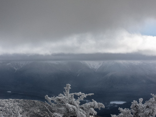 The Presidentials in the Clouds by EPICAC, on Flickr
|
|
#
?
Jan 7, 2013 18:33
|
|


|
Hot drat EPICAC, that is pretty much my favorite way for trees to look. I'm still eagerly awaiting some sort of consistent snowpack here in CO - I can still see patches of dirt up high on some 14ers on my drive into work in the morning and it makes me sad.
|
|
#
?
Jan 7, 2013 18:59
|
|

|
single-mode fiber posted:Also go to Grayson around the 2nd week of June (though this past winter was so warm, it was more like the last week of May) to see the rhododendrons bloom. Incidentally, this is also around the same time that the ponies will be having even-smaller baby ponies following them around. Thanks for the information I will check out both. I really enjoy the more remote hikes although I will be sure to go back to Grayson Highlands around the end of May. I did a nice day hike up Mt. Rogers on Monday. There is no view from the top though so I took this one right before the spur trail off the AT. 
Stalker fucked around with this message at 00:48 on Jan 10, 2013 |
|
#
?
Jan 10, 2013 00:45
|
|

|
Yautja Philosophy posted:I'm not experienced or advanced by any stretch of the imagination, but I love hiking and want to start going more often once my car is finally fixed. I'm in Orange County, CA, and if I could be added to the list, I'd be really excited to find some people to go with. Hey there OC hiker buddy, I don't have PM's, but you email me at SAManstrosity at gmail. I try and be out somewhere most weekends.
|
|
#
?
Jan 10, 2013 01:00
|
|

") I used to hike as a kid all the time with my family, but since my parents are on the older side (mid-60's, I'm early 20's), we stopped camping when I was a teenager. There's a wealth of downright gorgeous places around here, from deserts to mountains to canyons, and it'd be nice to start seeing them again. I'm just always tentative about going alone.
I used to hike as a kid all the time with my family, but since my parents are on the older side (mid-60's, I'm early 20's), we stopped camping when I was a teenager. There's a wealth of downright gorgeous places around here, from deserts to mountains to canyons, and it'd be nice to start seeing them again. I'm just always tentative about going alone.
|
Anyone going to be in a bunch of National Parks in the next few months? I have four months left on my yearly pass, but there's no way I'm going to make it to any more in that time frame. The card allows for two people, so I can mail it to someone who can just write their own name in and use it.
|
|
#
?
Jan 11, 2013 01:38
|
|

|
Woot! Just arranged my Atlanta pick up ride to take me to Amicola in a few weeks. She's even gonna hike up to Springer with me and let me spend a night so I don't have to start right after a 12 hour bus ride! Tons to do before I take off, but since this is the first official arrangement I've made, the clock is now ticking and I can get prepping! My hammock screen top tore last summer when I flipped in it. Not sure if I can get the company to repair it before I take off or to just use one without a screen. People who are early on the trail tend to get the worst of Maine's Black Fly season, don't they? How many SA posters will be out there this year? Elijya fucked around with this message at 06:51 on Jan 11, 2013 |
|
#
?
Jan 11, 2013 06:37
|
|

|
Elijya posted:My hammock screen top tore last summer when I flipped in it. Not sure if I can get the company to repair it before I take off or to just use one without a screen. People who are early on the trail tend to get the worst of Maine's Black Fly season, don't they? Would have to be pretty early, black flies are usually done by some point in June or July in New England.
|
|
#
?
Jan 11, 2013 07:12
|
|


|
Elijya posted:My hammock screen top tore last summer when I flipped in it. Not sure if I can get the company to repair it before I take off or to just use one without a screen. Who made the hammock? quote:How many SA posters will be out there this year? I'll be, but not until mid April at the earliest. The only major thing I have left to decide on is the pack, but I'm waiting to get my hammock kit from Warbonnet first.
|
|
#
?
Jan 11, 2013 17:18
|
|

|
Elijya posted:How many SA posters will be out there this year? Possibly. Might be on the cdt or I might be on the at. Just depends on a few things that are still up in the air.
|
|
#
?
Jan 11, 2013 17:26
|
|
|
Stalker posted:There is no view from the top though so I took this one right before the spur trail off the AT. Yeah, that's the one disappointing thing about Mt. Rogers. My favorite views always came from parts of Rhododendron Gap, Wilburn Ridge, and the Twin Pinnacles near Massie Gap. I only had a cell phone camera at the time, unfortunately, but I took these last summer and fall.  
|
|
#
?
Jan 11, 2013 18:50
|
|

|
Go ahead and add me to the list for Dallas, TX. My backpacking and hiking experience as of late has been pretty pathetic, but one of my goals for 2013 is to get out a bit more. Currently eyeing a few parks, trails and mountains in Arkansas and Oklahoma, maybe even out to New Mexico and Colorado if I can stretch my budget to match my ambitions.
|
|
#
?
Jan 11, 2013 20:33
|
|

|
Does anybody have any advice for estimating how long a thru-hike will take? I'm planning on thru-hiking the Superior Hiking Trail once spring rolls around, but I'm not sure how I should be calculating the amount of time I should be taking to do it. Also, do you guys have any recommendations for good foods/drink additives to take with so that I'll be actually getting a balanced diet while I'm out on the trail?
|
|
#
?
Jan 12, 2013 03:13
|
|
|
I'm looking for a good first aid kit for small-group day hikes (1-2 people usually, 4 at the most). I think I read in the last thread that the Adventure Medical Kits are recommended due to the waterproofing; is this still the case or is there a different kit I should look at? Edit: thought I put this in, but I'm in Colorado.
|
|
#
?
Jan 12, 2013 03:38
|
|


|
.
chad radwell fucked around with this message at 15:03 on Sep 13, 2015 |
|
#
?
Jan 12, 2013 03:55
|
|

|
Belmont Geoffrion posted:Does anybody have any advice for estimating how long a thru-hike will take? I'm planning on thru-hiking the Superior Hiking Trail once spring rolls around, but I'm not sure how I should be calculating the amount of time I should be taking to do it. Also, do you guys have any recommendations for good foods/drink additives to take with so that I'll be actually getting a balanced diet while I'm out on the trail? Well, to give you an idea, people usually thru hike the AT (about 2184 miles) in around 5 to 7 months, which works out to an average of 12 miles a day. Usually people start off with relatively short (5 to 10 mile) days until they get into shape, then they start doing more mileage, especially when they get to flatter areas. If we conservatively estimate that you can average 8 miles a day, it would take you about 34 days. I have no idea how difficult the trail is or what kind of shape you're in, so you might be able to do a lot better than that. As for food, this is better than anything I could tell you: http://andrewskurka.com/2012/food-planning-for-multi-day-hikes-and-thru-hikes/
|
|
#
?
Jan 12, 2013 04:05
|
|


|
Speaking of the AT, is there a resource that can tell me what to expect weather wise along the trail? I know that Whiteblaze has daily weather stats along the trail but that doesn't seem to help me plan what kind of weather to predict in certain locations at certain times, unless I'm missing something about how to use that page?
|
|
#
?
Jan 12, 2013 12:50
|
|

|
Belmont Geoffrion posted:Does anybody have any advice for estimating how long a thru-hike will take? I'm planning on thru-hiking the Superior Hiking Trail once spring rolls around, but I'm not sure how I should be calculating the amount of time I should be taking to do it. Also, do you guys have any recommendations for good foods/drink additives to take with so that I'll be actually getting a balanced diet while I'm out on the trail? Depending on you and terrain it can look like this, 20-30 km or ~12-18 miles every 8 hours with a 45lb load. Cut that by half if going thru rough terrain, like snow or dense forest, climbing more than 1200-2000ft in elevation every 2 hours will have diminishing returns. You have to know how fast you walk with a load on, I've got years of practice in the Army so much so that I did a 80km trip and I knew exactly when I would finish, around 1pm on the 4th day, so you can get pretty accurate with it. Xenixx fucked around with this message at 19:11 on Jan 12, 2013 |
|
#
?
Jan 12, 2013 19:05
|
|
|
Are there still Canadian hikers around? I'd like to spend some time hiking and exploring Banff this year. What time of year is my best bet to go during? Would I be best off doing multi-day trips or multiple day hikes and stay in a hotel? Also are there any required passes/reservations I'd have to make. Also I noticed there seems to be plenty of water around and am curious if there are any areas best accessed through kayak/canoe.
|
|
#
?
Jan 12, 2013 20:24
|
|

|
Calgary goon here. You're best bet for Banff is July and August. The past few years, there were still avalanches in June and I was caught in a blizzard 30km from my car September 1. I am still working on my Canadian Rockies Mountain Parks guide, I promise! My life is just kind of nuts right now. You will need a National Parks pass for every day you're in the park, as well as a back country reservation fee for overnight back country camping, and possibly a campfire fee if fires are permitted at the particular site. It covers the cost of firewood, which you can take at your leisure. I rarely end up at sites with that, however. There's not very many. Travelling by water is actually pretty difficult. There are only a couple of large rivers that aren't high class whitewater rapids rushing down rocky gullies, and even then you're going to encounter lots of waterfalls, and sometimes dams. A lot of the large lakes like Minnewanka or Spray Lakes are actually man-made reservoirs. I'm not super-familiar with paddling routes beyond day trips here, but I would imagine you'd spend as much time (or more) portaging. Plus big rivers tend to have roads running parallel to them for large sections, like the Bow and Highway 1. There are a ton of multi-day back country trips you can do. The Great Divide Trail passes right through the park, and I've spent some time on a couple of sections. Amazing trail. There's an excellent PDF file of a pamphlet of official back country trails and campsites in the park at the bottom of this page. http://www.pc.gc.ca/pn-np/ab/banff/activ/activ33/aa.aspx Some routes even head to alpine huts, which are awesome places to stay. You often have to book those ahead of time though, since space is incredibly limited and many mountaineers use them as basecamps. As for the hotel and day hike option, that's perfectly feasible too. There are tons of official trails of all levels. The "hardest" official day hike is the summit of Mt. Fairview. It's an easy scramble. I've done it early July and there was still a lot of snow on the trail, and we were snowed on while on the summit. There's also loads of unofficial trails tended to by volunteers. Many of them are actually wildlife trails that people just keep free of deadfall and other debris. Some go to summits, some don't. There's tons of guidebooks available. Some good ones are: Scrambles in the Canadian Rockies, Don't Waste Your Time in the Canadian Rockies, and Where the Locals Hike. For websites, I like a few as well that I use to get ideas, and make suggestions for friends: http://hikingwithbarry.com/ http://hikealberta.com/hike http://www.clubtread.com/Routes/ByRegion.aspx?Region=13 Before heading out, always check trail reports! There are often closures and warnings in all areas of all the parks any time of the year. These are mostly due to wildlife concerns, like bears or cougars in the area, or particular breeding seasons. Many trails are closed in May and June to give Bighorn sheep, elk, or caribou peace and quite during calving season. Any other questions, just ask! I'm in school to become a guide or start an adventure business out here, so I'm happy to answer what I know, or research what I don't know yet!
|
|
#
?
Jan 13, 2013 09:53
|
|


|
Akion posted:Solar Charger Skip it. There is a lot of cover on the AT, so it's going to be minimally effective. I'd take something like the Brunton power packs that have a USB port to charge devices and can be wall charged. Another way to approach power management is to base everything off of AA batteries. There are chargers that convert them to USB so you can charge your devices. Point and shoot cameras, GPS (like a Garmin Foretrex 401), and headlamps also all use them. You'll also be able to find them at nearly every store front in America, and can swap them around if you run low. For example if your headlamp or GPS die you can pull them from your camera. It will also alleviate the need to go find a place to charge all your stuff. The negatives are that they're nowhere near as efficient as the battery pack Akion suggested, they weigh considerably more, and you're going to be throwing them away instead of reusing them which is not very environmental friendly. You also can't utilize a solar panel unless you run some weird setup and rechargeable AAs, and that defeats the purpose. The cost will probably also catch up to you depending on how long your trip will be. edit: Incase anyone is into McGyver kinda stuff, I also found this: http://www.robots-everywhere.com/re_wiki/index.php?title=Ersatz_battery_booster https://www.youtube.com/watch?v=RVUbIMncjqM Pretty much makes one of those battery chargers for your phone for $2.50, inside of a RadioShack. I'm going to make one today and try it out to see if its worth throwing into my pack. iceslice fucked around with this message at 21:20 on Jan 13, 2013 |
|
#
?
Jan 13, 2013 20:08
|
|
|
Went on a trip with my employer's (a university) outing club on Sunday. We went up Mount Hight and Carter Dome in New Hampshire. The weather was unusually warm for this time of year (temperatures were in the mid 40s). The trip leaders made the mistake of not having all of the participants bring/rent snowshoes, so most people ended up postholing once the temperatures warmed and the snow became slushy. I'm glad I had my snowshoes. Aside from the unseasonable temperatures, the weather was great. There were great views from Hight, and some good views from a lookout on Carter Dome. The snow was mostly too soft to glissade on the way down, except for a steep section descending into Carter Notch.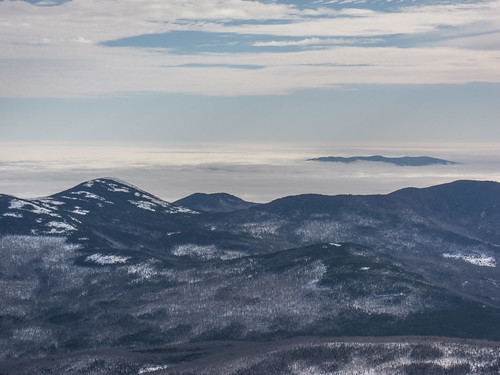 Undercast by EPICAC, on Flickr 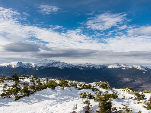 The Northern Presidentials by EPICAC, on Flickr 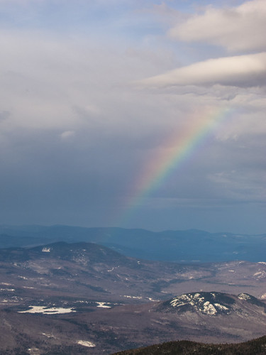 Rainbow from Carter Dome by EPICAC/url], on Flickr [url=http://www.flickr.com/photos/41566708@N08/8385532810/] 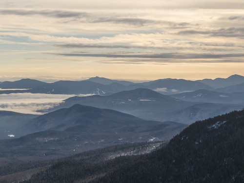 Descent to Carter Notch by EPICAC, on Flickr  Carter Lakes by EPICAC, on Flickr
|
|
#
?
Jan 16, 2013 19:04
|
|
|
EPICAC posted:Mount Hight and Carter Dome Awesome pictures. I went up Mt. Pierce on Sunday with an AMC group. So weird to be be hiking up a mountain in January and have a warm breeze coming down the slope towards you. We didn't find out till later but a group of Tufts students got lost coming down Pierce the previous day and had to get rescued (http://www.unionleader.com/article/20130112/NEWS07/130119741c).  Eisenhower and Washington
|
|
#
?
Jan 17, 2013 03:07
|
|
|
I've never done a day trip over ten-odd miles before--is that vastly different from thirty miles in a day? If so, what should I do to prepare in the five months prior? Tthe local outdoors shop is planning to traverse about that distance on the AT in a day for charity, and I'd love to participate, but I wouldn't even know where to start 
|
|
#
?
Jan 17, 2013 05:32
|
|


|
Swillkitsch posted:I've never done a day trip over ten-odd miles before--is that vastly different from thirty miles in a day? If so, what should I do to prepare in the five months prior? Tthe local outdoors shop is planning to traverse about that distance on the AT in a day for charity, and I'd love to participate, but I wouldn't even know where to start Just hike a ton, and do more every day. Thing is, you probably can do 30 miles in a day in your current condition, but it'll be awful and painful and you'll feel like poo poo for a week. If you can build yourself up into good shape, then you'll be able to do it and have fun and feel okay the next day.
|
|
#
?
Jan 17, 2013 06:28
|
|
|
Swillkitsch posted:I've never done a day trip over ten-odd miles before--is that vastly different from thirty miles in a day? If so, what should I do to prepare in the five months prior? Tthe local outdoors shop is planning to traverse about that distance on the AT in a day for charity, and I'd love to participate, but I wouldn't even know where to start Practice makes possible. Do all the hiking. If the trip is going to have any elevation gain make sure you get used to it before hand. Get familiar with your gear so you can be comfortable whatever the weather conditions turn out to be and so that you're not miserable carrying a pack full of junk you wont need. Also, lift a weight.
|
|
#
?
Jan 18, 2013 02:27
|
|
|
If you plan on backpacking a lot and have never done it before, really please work out.
|
|
#
?
Jan 19, 2013 18:08
|
|


|
I realize that there is no replacement for proper hiking shoes, but is there any traction device that you can buy for running shoes that would improve traction while hiking (something like for icy, slippery walks)?
|
|
#
?
Jan 19, 2013 20:11
|
|

|
I much prefer microspikes to yaktrax, myself. It depends on terrain, though. Yaks are fine for flat ice or packed snow, but if you run into ice on any sort of an incline there's no replacement for some form of spikes. I guess the big questions are how hilly your intended trail is, and whether you mind taking the time to remove them when you encounter large patches of bare rock. Edit: Ah, that I'm less familiar with. I'm not sure there's much you can do aside from selecting footwear with an aggressive tread, but another goon might have good advice. TerminalSaint fucked around with this message at 20:47 on Jan 19, 2013 |
|
#
?
Jan 19, 2013 20:33
|
|
|
TerminalSaint posted:I much prefer microspikes to yaktrax, myself. It depends on terrain, though. Yaks are fine for flat ice or packed snow, but if you run into ice on any sort of an incline there's no replacement for some form of spikes. I guess the big questions are how hilly your intended trail is, and whether you mind taking the time to remove them when you encounter large patches of bare rock. melon cat fucked around with this message at 20:47 on Jan 19, 2013 |
|
#
?
Jan 19, 2013 20:36
|
|
|
melon cat posted:We're actually hiking in a very hot, potentially-muddy region (Hawaii). From what I've heard, Yaktrax only works for icy conditions. Anything for muddy, jungle-like treks? Where you hiking? I just did a few hikes in Hawai'i.
|
|
#
?
Jan 19, 2013 22:45
|
|


|
alnilam posted:Where you hiking? I just did a few hikes in Hawai'i. We'll be in Honolulu. Had my sights set on Palolo Valley, as suggested by another forumgoer. Which island were you on?
|
|
#
?
Jan 20, 2013 04:35
|
|
|
melon cat posted:We'll be in Honolulu. Had my sights set on Palolo Valley, as suggested by another forumgoer. Which island were you on? Heard great things about there... I myself only hiked manoa falls while near Honolulu. But I heard palolo was the best hike around there - that and the stairway to heaven. My main hike on that trip was the kalalau trail on kaua'i. I'll post more when I'm not on my phone!
|
|
#
?
Jan 20, 2013 05:09
|
|
|
alnilam posted:Heard great things about there... I myself only hiked manoa falls while near Honolulu. But I heard palolo was the best hike around there - that and the stairway to heaven. melon cat fucked around with this message at 05:51 on Jan 20, 2013 |
|
#
?
Jan 20, 2013 05:45
|
|
|
Can anyone offer an opinion on the Tarptent Notch? I have a big agnes fly creek UL 2 and I would like to save a few ounces on solo trips on the AT.
|
|
#
?
Jan 20, 2013 21:39
|
|

|
I've had the urge to pick up hiking or backpacking for a few years now and haven't really acted on it. I currently live in central OK, which is pretty flat. Can anyone recommend some good parks for day hikes in Oklahoma, Arkansas or north Texas?
|
|
#
?
Jan 21, 2013 05:03
|
|


|
Wanted to chime in with my US military surplus backpacking getup. Mostly, milsurp gear (that I encounter in WI) is ideal for winter/weeklong backpacking. I picked up an older ALICE frame pack a year or so ago and was impressed with how much space it had in there. After taking it to the grocery store and back, I realized I DESPISED the stock straps on that thing. Google led me to putting current-generation MOLLE straps and a backpad on there, which made a world of difference. I picked up a current-issue 4-layer coldweather sleeping bag as well, which fits in a nice pouch made for the MOLLE system which conveniently also attaches to the bottom of the ALICE frame. I've found that ideally you'll want to load up the weight in the middle of the bag, and use your somewhat lighter clothes as "shims" to keep the heavy load in the center of the pack. It's a relatively heavy setup compared to a summer load, especially with weapons and ammunition if you're hunting too. I feel that the ability to carry a reasonably weatherproof sleeping bag and an extra change of clothes or two is worth the trade-off. If you find yourself yearning for the outdoors despite the cold, you will likely find at least a few things at the military surplus store that will alleviate one or two major headaches. Always check the quality of any item you purchase, especially used, to make sure that it contains all of the parts necessary to make it work, and that excessive fraying has not ruined the structural integrity of any fabric items.
|
|
#
?
Jan 21, 2013 06:28
|
|

|
|
| # ? May 21, 2024 14:30 |
|
|
Mercury Ballistic posted:Can anyone offer an opinion on the Tarptent Notch? I have a Notch. It kicks rear end. Setup and teardown are surprisingly easy (there's a good video of it on the Tarptent site). Getting in and out of the tent is easy. The vestibules are pretty big. The inside of the tent itself is about big enough for your sleeping bag, a water bottle, and a flashlight. You do have to seam seal it yourself, but it's really not that bad.
|
|
#
?
Jan 21, 2013 07:04
|
|