|
You'd also presumably need the co-operation of the Chinese government, which they would be disinclined to give as they have been selling their own state-sanctioned version of Chinese history that actual historical documents would likely reveal to be complete bullshit.
|
 #
?
Aug 2, 2013 17:04
#
?
Aug 2, 2013 17:04
|
|


|

|
| # ? Jun 1, 2024 10:13 |
|
|
TheBalor posted:You'll be waiting a long time. Even the Records of the Grand Historian, one of the most comprehensive early histories of China by Sima Qian, hasn't been translated fully into English. The undertaking is really too massive for any one scholar to perform, even with a team of grad student slaves. You'd need an organized effort by a big institution with lots of money behind it, and no other goals but translating Chinese sources into English ones. Too bad it's not a major religious text 
|
|
#
?
Aug 2, 2013 17:05
|
|

|
Have they not even been translated into modern Chinese or scanned out of their original forms then? It's strange to think about how much history is just sitting in the dust somewhere.
|
|
#
?
Aug 2, 2013 17:08
|
|

|
Fojar38 posted:You'd also presumably need the co-operation of the Chinese government, which they would be disinclined to give as they have been selling their own state-sanctioned version of Chinese history that actual historical documents would likely reveal to be complete bullshit. It was probably mostly lies to begin with though. (I'm not saying it wouldn't be very interesting of course.)
|
|
#
?
Aug 2, 2013 17:11
|
|
|
The problem with old Chinese texts is that a whole load of them got lost or destroyed because they did not fit later political climates. As a result of this much of the remaining works have been very carefully protected and are only accessible by small amounts of people, who have a tendency to be insular and traditional. The best bet to getting more information about subjects is if/when it suddenly gets popular. Loads of stuff about Zheng He was unearthed because of a surge in popularity. Despite careful protection even now works are getting lost, quite a few texts have been lost to fires for example.
|
|
#
?
Aug 2, 2013 17:24
|
|

|
Davincie posted:The problem with old Chinese texts is that a whole load of them got lost or destroyed because they did not fit later political climates. As a result of this much of the remaining works have been very carefully protected and are only accessible by small amounts of people, who have a tendency to be insular and traditional. The best bet to getting more information about subjects is if/when it suddenly gets popular. Loads of stuff about Zheng He was unearthed because of a surge in popularity. Despite careful protection even now works are getting lost, quite a few texts have been lost to fires for example. What type of things were unearthed?
|
|
#
?
Aug 2, 2013 17:26
|
|

|
cheerfullydrab posted:Yeah direct contact between the Chinese and the Romans was definitely a thing. I have noticed in the Ask/Tell thread about Roman history that for some reason, a lot of people who post on the Something Awful Forums have a really really special and particular interest in learning about China-Ancient Rome contacts. I've wondered why that is for months now and I've come up completely empty as to a reason. From what I heard, the Sassanids regularly hosed with any attempts for the Romans and the Chinese to get in contact with each other. They were situated between the two and controlling trade was a very lucrative business for them, at least when they werent constantly warring with the Romans over whateverthefuck. During times of peace Roman envoys would come trying to scout out the trade route and the Sassanids would march everyone around in the desert in circles for months, then claim that China was still 3 months away.
|
|
#
?
Aug 2, 2013 17:58
|
|

|
Koramei posted:Have they not even been translated into modern Chinese or scanned out of their original forms then? It's strange to think about how much history is just sitting in the dust somewhere. You don't even have to look to ancient Chinese stuff or archaic language texts for that. I've spoken with people that deal in US Civil War and old west history: eras that have a lot of attention in scholarship and popular culture alike, and both with huge amounts of official records and other documents which could answer a lot of questions scholars and enthusiasts have, once it actually gets pulled out of boxes and cataloged in more modern fashion. It just would take funding and manpower that isn't really available, and that no one really wants to stick their neck out to provide for what often just amounts to pretty esoteric scholarship and pub trivia info.
|
|
#
?
Aug 2, 2013 17:58
|
|


|
Yeah. Young historians who might have the time and the passion for a colossal work like this would never be able to get the funding. Older historians who could get the funding wouldn't have the time to see it completed, and usually just want to enjoy their golden years.
|
|
#
?
Aug 2, 2013 18:04
|
|

|
Bishop Rodan posted:
Very cool. Here is similar style Chinese map from 70 years later, they had got quite a bit better at getting the world geographically accurate in that time. http://en.wikipedia.org/wiki/Shanhai_Yudi_Quantu
|
|
#
?
Aug 2, 2013 18:39
|
|


|
I have to say their 1532 map was pretty terrible. I know they were very insular at this point, but it still surprises me a little. Even those ancient Greek maps where the Indian Ocean is an inland sea are better than that.
|
|
#
?
Aug 2, 2013 19:13
|
|


|
Phlegmish posted:I have to say their 1532 map was pretty terrible. I know they were very insular at this point, but it still surprises me a little. Even those ancient Greek maps where the Indian Ocean is an inland sea are better than that. Heres the oldest map they found apparently.  Not that bad actually and I think its quite pretty with all the little towns and mountains.  Though that makes those terrible later maps all the more strange. 
|
|
#
?
Aug 2, 2013 19:19
|
|
|
Knowledge gets lost, I guess. It really is kind of weird how they can get the shape of the continents almost right, but just gently caress it up entirely and make them look like weird string-cheese. Speaking from the perspective of someone crazy into cartography/makes maps of their own in their free-time, I love that oldest map. The detail's just awesome and all those little towns and mountains and hills and rivers and .Are there any copies of it in a higher resolution?
|
|
#
?
Aug 2, 2013 19:23
|
|

|
Lawman 0 posted:Heres the oldest map they found apparently. How old is that? Song dynasty or would you get anything that well preserved from so long ago? Also here's a Tabula Rogeriana, created by sicilian muslims under roger II of Sicily in the mid twelfth century, though the oldest copy still around is from the fourteenth century. 
khwarezm fucked around with this message at 21:01 on Aug 2, 2013 |
|
#
?
Aug 2, 2013 20:52
|
|

|
It's usually a bad idea to try and interpret maps without knowing to what end they were designed, or what the information depicted means. For example it would be a bad idea to judge a subway map because it distorts physical distances which it was never designed to convey. Here's an image from the Roman tabula peutingeriana, which while a very accurate map of Roman roads and very useful for someone traveling by land, doesn't much resemble actual geography. Roman Britain. That's Spain at the bottom there. Another alternative is that the map isn't even trying to depict geography and is making some kind of symbolic point, like medieval christian maps that depict Jerusalem as the center of the world.  Yeah gonna have a hard time trying to navigate anywhere with this. Personally I have no clue what that 1532 map is depicting, looks like China is an island? I dunno what the gently caress. But it has gone into a lot of detail with the rivers which suggests it is not designed arbitrarily.
|
|
#
?
Aug 2, 2013 20:54
|
|

|
Squalid posted:
Is that map in this thread somewhere, I love the face in the chest people who live in Libya
|
|
#
?
Aug 2, 2013 20:57
|
|

|
This map kicks rear end so much. Are there more symbolic maps like this?
|
|
#
?
Aug 2, 2013 21:08
|
|
|
Here's a 16th century map of the Nordic countries 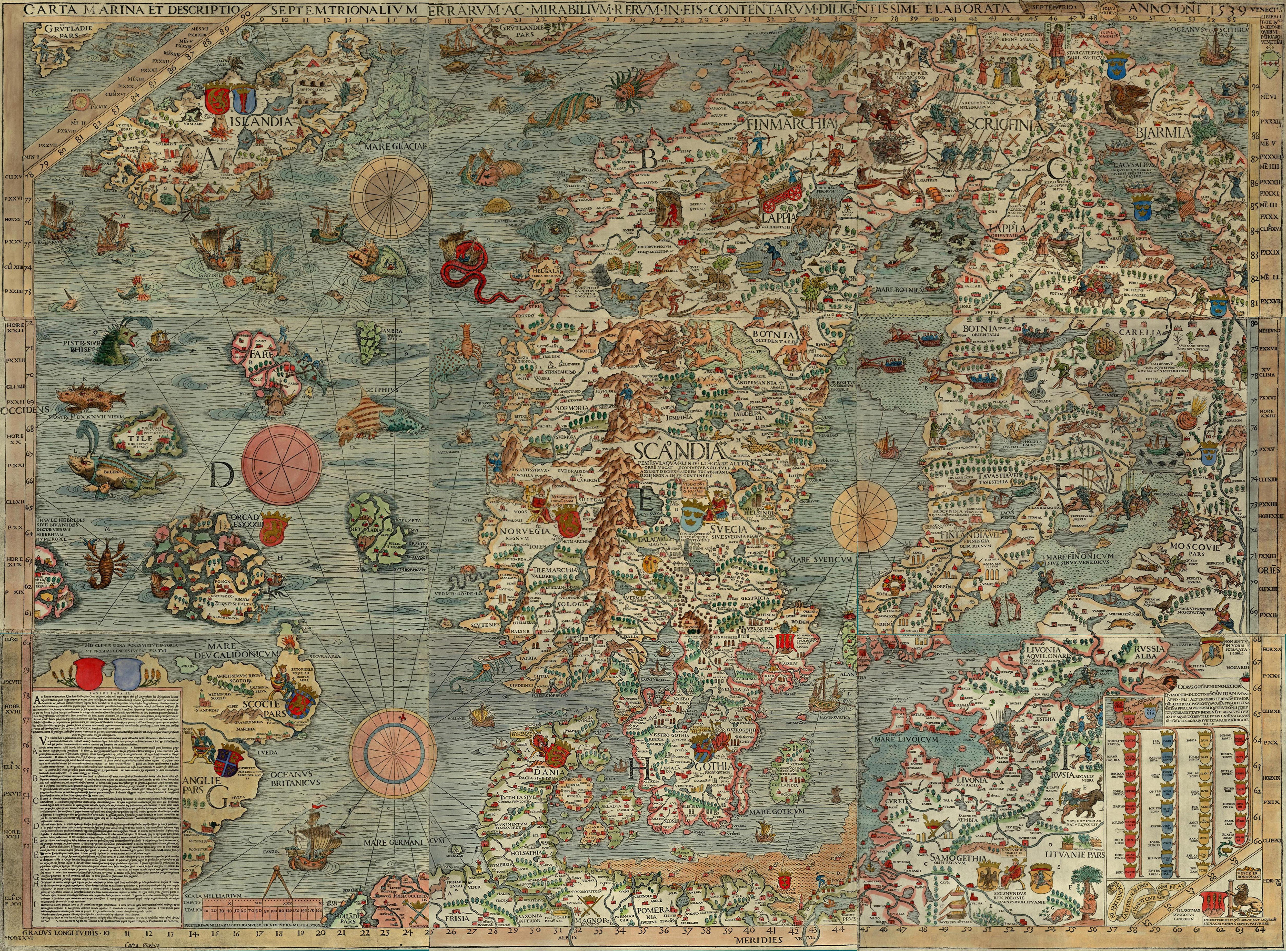 Full resolution http://upload.wikimedia.org/wikipedia/commons/e/ea/Carta_Marina.jpeg
|
|
#
?
Aug 2, 2013 21:09
|
|
|
Killer robot posted:For an extra bonus, combine it with draining the North Sea: I love how the new, reclaimed land has no topography whatsoever, so they have to divert the Rhine all the way to the channel. If it wasn't like that, the drained land would just fill back up! 
|
|
#
?
Aug 2, 2013 21:09
|
|


|
khwarezm posted:How old is that? Song dynasty or would you get anything that well preserved from so long ago? It took me a minute to figure out this map was upside down. South is up.
|
|
#
?
Aug 2, 2013 21:12
|
|

|
and here I was thinking the persian gulf was the nile
|
|
#
?
Aug 2, 2013 21:26
|
|


|
wikipe tama posted:Is that map in this thread somewhere, I love the face in the chest people who live in Libya I know exactly the picture you're describing but i dunno. There are a whole bunch of maps depicting Jerusalem as the center of the world, I just posted the first one I found on google.
|
|
#
?
Aug 2, 2013 21:28
|
|
|
Squalid posted:Another alternative is that the map isn't even trying to depict geography and is making some kind of symbolic point, like medieval christian maps that depict Jerusalem as the center of the world. This map is also done in the shape of the coat of arms of Hannover, the city where the artist was born. My favourite part is how they completely forgot to include China.
|
|
#
?
Aug 2, 2013 21:34
|
|

|
Squalid posted:
Took me a while to see it, but yeah the 1532 map is meant to be geographically accurate, and it sort of is with China's immediate neighbours. North is up, and the white bits are land. Japan is the island on the far right hand about half way up, so this is the far eastern edge. To the left of Japan you can see the shape of Korea and China (including the Great Wall), below China is India. As you go further west it all goes to bullshit, though; the cartographer believed there was an ocean between Europe and Asia, and I guess also that the world was symmetrical. The Real Quaid fucked around with this message at 21:46 on Aug 2, 2013 |
|
#
?
Aug 2, 2013 21:43
|
|
|
Peanut President posted:It took me a minute to figure out this map was upside down. South is up. Upside down is an arbitrary term  . .https://www.youtube.com/watch?v=n8zBC2dvERM
|
|
#
?
Aug 2, 2013 21:46
|
|
|
Squalid posted:It's usually a bad idea to try and interpret maps without knowing to what end they were designed, or what the information depicted means. For example it would be a bad idea to judge a subway map because it distorts physical distances which it was never designed to convey. Here's an image from the Roman tabula peutingeriana, which while a very accurate map of Roman roads and very useful for someone traveling by land, doesn't much resemble actual geography.  The Tabula Peutingeriana even shows a Temple of Augustus at the trade city of Muziris. And on the subject of ancient politically loaded maps, we have Prester John, a legendary Christian king of the east who the Christians of Europe saw as their salvation from Muslim dominion. In this map his kingdom is identified with Ethiopia/Abyssinia:  (Source: Strange Maps) e: I almost forgot my favorite old map, the Erdapfel ("earth apple"). Notable for being the first known world globe.  Also notable, the year it was made: 1492. Right before people were about to realize that that big ocean between Europe and Japan shouldn't be empty:  (Also note Saint Brendan's Isle, one of a number of fictional islands that popped up in a lot of older maps.) Lord Hydronium fucked around with this message at 22:01 on Aug 2, 2013 |
|
#
?
Aug 2, 2013 21:52
|
|


|
What is Saint Brendan, the Azores?
|
|
#
?
Aug 2, 2013 22:03
|
|
|
I know this isn't bookchat, but for those who like all those old and early maps of the world, I'd suggest giving The Fourth Part of the World a read, or at least read the synopsis to see if it's your forte.
|
|
#
?
Aug 2, 2013 22:06
|
|

|
wikipe tama posted:What is Saint Brendan, the Azores? The Azores are above the canaries on that map.
|
|
#
?
Aug 2, 2013 22:07
|
|
|
wikipe tama posted:What is Saint Brendan, the Azores?
|
|
#
?
Aug 2, 2013 22:08
|
|
|
Peanut President posted:It took me a minute to figure out this map was upside down. South is up. It's funny how even heavily abstracted maps like that can make me nauseous when they are upside down.
|
|
#
?
Aug 2, 2013 22:10
|
|

|
Dusseldorf posted:Wyoming was one of the few places onto Harding from the start. Was the Teapot Dome scandal already brewing at this time or was it a way of paying back his friends there. I don't know. I doubt it. Because on the second through fourth ballots, Wyoming had no delegates supporting Harding. And on the fifth through eighth ballots, only one delegate voted in favor of Harding. It wasn't until ninth ballot that Harding received all of Wyoming's votes--but by then, the convention was already swinging in his favor.
|
|
#
?
Aug 2, 2013 22:12
|
|
|
Those 16th century maps from China are actually meant to be both correct AND symbolic. They represent a reactionary style of mapmaking in which East Asian authors tried to reconcile Western technical approach and traditional philosophical - political view of the world in certain Buddhist oriented cultures. In which the world is actually a disc divided into cosmologically significant parts / continents, which are depicted in a more or less prescribed graphical fashion - maps of this world can be basically read as a book describing interlinkage of various categories in a locally developed cosmology. The continent inhabited by humans (Jambudvipa), more widely understood as the land in which one can seek spiritual enlightenment, is the Southern of 4 continents making up our complex Earth, and is isolated from the other continents by circular seas and mountainous islands: The Chinese traditionally envisioned themselves as the centre of this continent. That's why it looks like the author made up random continents to fill the border of the map, and why everything is warped, and why the older map is so strangely symmetrical: Authors of these maps had to adhere to the notion of China as the central point of a mythical topographically enclosed region with strongly prescribed geometric patterns, and at the same time put in as much detail as they could to compete with the foreigners.
|
|
#
?
Aug 2, 2013 22:17
|
|


|
The Real Quaid posted:Took me a while to see it, but yeah the 1532 map is meant to be geographically accurate, and it sort of is with China's immediate neighbours. North is up, and the white bits are land. Japan is the island on the far right hand about half way up, so this is the far eastern edge. To the left of Japan you can see the shape of Korea and China (including the Great Wall), below China is India. As you go further west it all goes to bullshit, though; the cartographer believed there was an ocean between Europe and Asia, and I guess also that the world was symmetrical. Do you read Chinese? I'd hesitate to make that conclusion without understanding the logic with which the map was designed. Seems pretty unlikely they'd believe in an ocean located between Europe and Asia, when they should have records of Mongols and merchants riding all that way. I mean I'm sure lots of it is wrong but hell if I could say which parts. It's all greek to me! er... Chinese
|
|
#
?
Aug 2, 2013 22:22
|
|
|
Lord Tywin posted:Here's a 16th century map of the Nordic countries Seeing all those sea monsters makes me think how scary it would have been to take the sea at the time. Sea superstitions and legends are so interesting. The Fata Morgana phenomenon is the scariest thing to me, it must be so surreal.
|
|
#
?
Aug 2, 2013 22:27
|
|

|
Speaking of West-meets-East, here's the kingdom of King Menander I/Milinda, a Grecco-Bactrian ruler of Northern India/Pakistan. His contributions to Buddhism include the influence of Hellenistic realist sculpture on visual depictions of the Buddha, and a Buddhist text called the Milinda Panha supposedly documenting his conversion to Buddhism. EDIT: Isn't Japan on the left half of the 1532 map? The little island chain labeled 本日. Unless I'm misreading what people are saying. EDIT2: I was looking at the ~1600 map, not the 1532 map, I'm dumb. A Fancy 400 lbs fucked around with this message at 00:17 on Aug 3, 2013 |
|
#
?
Aug 2, 2013 22:44
|
|
|
Squalid posted:Do you read Chinese? I'd hesitate to make that conclusion without understanding the logic with which the map was designed. Seems pretty unlikely they'd believe in an ocean located between Europe and Asia, when they should have records of Mongols and merchants riding all that way. I mean I'm sure lots of it is wrong but hell if I could say which parts. It's all greek to me! er... Chinese I do not read Chinese, but a poster above identified (大秦國) as the word for Daqin (Roman Empire), which can be found written on the continent to the left of the ocean. I googled the Chinese word for Japan (日本) which are the first 2 glyphs on the island on the right. Hard to believe that Chinese people really thought that Europe was not on the same land mass, I agree. Perhaps it was separated for symbolic reasons, and after reading steinrokkan's post I could imagine that could be the case.
|
|
#
?
Aug 2, 2013 23:01
|
|
|
Peanut President posted:It took me a minute to figure out this map was upside down. South is up. Arabic cartography, all maps had the south pointed up. Idrisi's map in arabic  Maududi, this image was flipped, but note the arabic is upside down here. 
|
|
#
?
Aug 3, 2013 05:16
|
|


|
Lawman 0 posted:Heres the oldest map they found apparently. It's pretty, but also super inaccurate. You can clearly see China, Korea, Japan on there, but that little dangly lake thing to the west? That's Europe. You can make out Italy, and the lake is the Mediterranean. So on a world scale it's still wildly off, but it's very cool and it also shows China's perspective on things.
|
|
#
?
Aug 3, 2013 05:24
|
|


|

|
| # ? Jun 1, 2024 10:13 |
|
|
Shouldn't it be Africa and not Italy?
|
|
#
?
Aug 3, 2013 09:19
|
|