|
Fojar38 posted:Is that series any good by the way? I think it has an interesting premise but what I'm told is that everything that happened in real life happened again except it was Chinese and Arabian. It's a brilliant book but it isn't really concerned with being a realistic alternate history. It's more spiritual.
|
 #
?
Jan 15, 2014 05:34
#
?
Jan 15, 2014 05:34
|
|


|

|
| # ? May 23, 2024 19:21 |
|
|
Religious map of the British Indian Empire: I always find maps like this weird because of the hard lines where one religion stops and another one starts. It would work if they also showed minority religions in an area as well, but since it's called "prevailing religions" I guess they couldn't do that. It's also interesting that you can already see where Pakistan ended up being. ")
Kamrat fucked around with this message at 06:55 on Jan 15, 2014 |
|
#
?
Jan 15, 2014 06:52
|
|

|
Do people who practice Hinduism consider everyone else who is said to practice Hinduism a Hindu? Obvious answer is "yeah, duh, they practice Hinduism" but India is a huge subcontinent with a huge number of people and cultures. Do they all consider each other to be Hindus or do they find difference in each other? Is that difference substantial? Are there people the West may say are all Hindus but people in another part of India would say they are not?
|
|
#
?
Jan 15, 2014 07:45
|
|

|
Almost certainly yes to all of those, but keep in mind that that map was probably not written with any regards to religious sensitivity.A Buttery Pastry posted:How is Han migration causing the physical destruction of in whole or in part of the Tibetan people? Forced cultural assimilation has been a common practice of China for most of its history and is massively destructive to those they subsume. Whether that's actually genocide or not (it's funny, they go to lengths to make their wording as unambiguous as possible in these definitions but there is still way too much room for debate) is ... maybe not as concrete as I had assumed, on reading a little more about it, but as I said that's entirely semantics. China's ills in Tibet have been way overblown in the west for sure, and it's a good thing to counter the boogeyman image they're acquiring, but "have not performed forced sterilization or killed as many Tibetans as there are Tibetans" is not to say they are not doing all kinds of wrong there. All that said I agree with your side of the argument; excusing a repressive and feudal government 'cause "every premodern state was as bad" seems a bit weird when the time period we're talking about is centuries after most of the rest had been reformed. It is not analogous to colonization. semi-related: Asia in the early 20th century 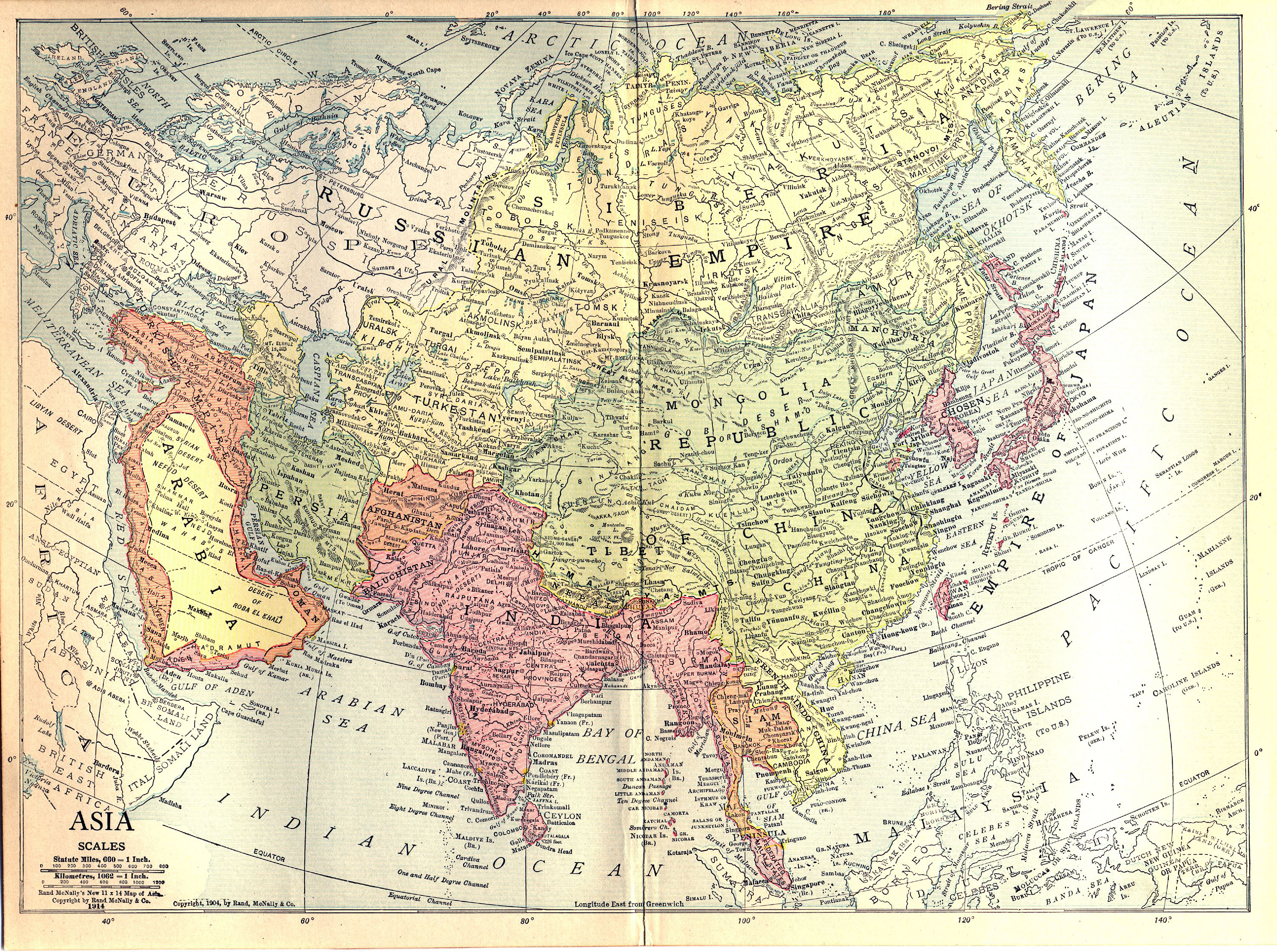 (click for bigger if you wanna see cities and whatever. look at all that Wade-Giles  ) )
Koramei fucked around with this message at 08:07 on Jan 15, 2014 |
|
#
?
Jan 15, 2014 08:03
|
|

|
Koramei posted:Almost certainly yes to all of those, but keep in mind that that map was probably not written with any regards to religious sensitivity. I didn't think it was. It's just something I'm always curious about when I see religious maps, especially of India. 
|
|
#
?
Jan 15, 2014 08:31
|
|
|
Koramei posted:Forced cultural assimilation has been a common practice of China for most of its history and is massively destructive to those they subsume. Whether that's actually genocide or not (it's funny, they go to lengths to make their wording as unambiguous as possible in these definitions but there is still way too much room for debate) is ... maybe not as concrete as I had assumed, on reading a little more about it, but as I said that's entirely semantics. Koramei posted:China's ills in Tibet have been way overblown in the west for sure, and it's a good thing to counter the boogeyman image they're acquiring, but "have not performed forced sterilization or killed as many Tibetans as there are Tibetans" is not to say they are not doing all kinds of wrong there.  Ethnic map of modern China.  Ethnolinguistic map of China in 1935.
|
|
#
?
Jan 15, 2014 12:31
|
|


|
A Buttery Pastry posted:Yeah, I have no doubt the kind of policies China pursues are massively destructive to local cultures, I'm just not sure calling it genocide is the best idea when the scholarly resources on the subject don't support most people's definition of genocide. (Though the assimilationist policies probably only really stand out because of the sheer scale of the assimilation, present and past.) There are arguments for and against accepting the idea of 'cultural genocide' or substituting terms like ethnocide, but it's not as clear-cut an issue as you might think. Tibet is fairly regularly brought up as a case in genocide studies, along with Xinjiang and other cases in China actually (in response to your second point) -- see for example Uradyn Bulag, 'Twentieth-Century China', in The Oxford Handbook of Genocide Studies. Bulag comes down pretty strongly in favour of considering Chinese policy towards the Tibetans and Uygurs in particular a genocide, and makes a fairly cogent argument that hanhua ('Sinicization') is more than just assimilationism, it also 'has powerful genealogical and governmental dimensions; it is not primarily an "acculturation" process'. Bulag also lists precedents in early modern Chinese history. There's a pretty substantial literature on it but another obvious study would be Levenson's 'Tibet: A Neo-Colonial Genocide' in Forgotten Genocides: Oblivion, Denial, and Memory, which goes into some detail about the massacres of Tibetans in the wake of the Chinese occupation.
|
|
#
?
Jan 15, 2014 13:17
|
|

|
Similar to the uncolonized Africa map, here's one view of aboriginal Australia (David R. Horton, 1994). (Source; click image for big version.)  Brightly coloured blobs are tribal or language groups. Red lines divide regions. "The map attempts, using all the published resources available at the time, to represent all the language or tribal or nation groups of the indigenous people of Australia. [...] The regions were analysed by using the watershed basins as a template and then superimposing all the groups on that base and determining where such factors as culture, language and trade indicated the relationships between groups to be. [...] This map indicates only the general location of larger groupings of people, which may include smaller groups such as clans, dialects or individual languages in a group. Boundaries are not intended to be exact."
|
|
#
?
Jan 15, 2014 14:13
|
|
|
I'd expect there to be a big empty area in the desert. Did those tribes really live in those areas all the time or did they move in the summer?
|
|
#
?
Jan 15, 2014 15:06
|
|

|
Koramei posted:Almost certainly yes to all of those, but keep in mind that that map was probably not written with any regards to religious sensitivity. drat, I didn't know Taiwan was part of the Japanese conquests along with Korea.
|
|
#
?
Jan 15, 2014 16:17
|
|

|
Count Roland posted:drat, I didn't know Taiwan was part of the Japanese conquests along with Korea. For about 50 years. To this day Taiwan still has a Japanese affinity. The Japanese weren't anywhere near as brutal there as they were in other conquered territories. It was their first conquest so they wanted to show everyone how wonderful life under their new Japanese overlords would be. Grand Fromage fucked around with this message at 16:22 on Jan 15, 2014 |
|
#
?
Jan 15, 2014 16:19
|
|


|
Count Roland posted:drat, I didn't know Taiwan was part of the Japanese conquests along with Korea. Korea was just granted independence (it was a vassal of China for a long time), Taiwan was straight up given up like how Hong Kong was to the British (similar things happened in northern China and in Shandong but some of those we're given back by WW2). e: when I say granted independence I mean it was still effectively annexed it's just that China never considered Korea as a part of "real" China like Taiwan/other places were.
|
|
#
?
Jan 15, 2014 16:34
|
|

|
GreenCard78 posted:Do people who practice Hinduism consider everyone else who is said to practice Hinduism a Hindu? Obvious answer is "yeah, duh, they practice Hinduism" but India is a huge subcontinent with a huge number of people and cultures. There are vast differences between different traditions within Hinduism, and in some places Hinduism seems to fade into another religion without strict delineation. However there are a few beliefs almost everyone agrees define a Hindu, and anyone who accepts these beliefs is considered part of the faith. Gandhi outlined four principles he felt made him a Hindu, which I found very useful in understanding the religion. MK Gandhi in "Aspects of Hinduism" posted:I call myself a sanatani Hindu, because, The author Ramendra Nath argues that of these four points only one and two are truly defining. Still, if two quarrelsome Hindus are contending that the other is not truly of the faith, their argument will probably center around whether the person meets these criteria.
|
|
#
?
Jan 15, 2014 20:15
|
|
|
This is about as loaded as they come: Explanation key Found in a great set of maps, many of which have already been in this thread: 40 maps that explain the world and 40 more maps that explain the world
|
|
#
?
Jan 16, 2014 04:23
|
|

|
 Blue - wet county Red - dry country Yellow - semi-dry county I didn't realise quite how not dead prohibition is in the US. I guess a lot of the dry counties are really underpopulated and most of them aren't too far from a wet one, but it looks like in some areas you'd have to drive hundreds of miles to get a drink? I think the most surprising thing is that Kentucky and Tennessee which are pretty famous for booze are almost entirely dry.
|
|
#
?
Jan 16, 2014 18:30
|
|
|
XMNN posted:
Kentucky should have more yellow counties than it does on that map, since most towns above a certain size have alcohol sales of some sort. The liquor laws here are apparently a confusing nightmare, though.
|
|
#
?
Jan 16, 2014 18:40
|
|

|
XMNN posted:
What do the semi-dry counties in Michigan mean? I lived in a couple of them and I can't recall any difficulty getting alcohol except on Sunday mornings and after 1AM or 2AM, I forget which.
|
|
#
?
Jan 16, 2014 18:42
|
|


|
I still can't believe the United States ever tried to implement a nationwide prohibition. It's like something out of a fictional universe. What were they thinking?
|
|
#
?
Jan 16, 2014 18:43
|
|


|
Phlegmish posted:I still can't believe the United States ever tried to implement a nationwide prohibition. It's like something out of a fictional universe. What were they thinking? Women didn't like their drunken husbands coming home and beating them/their kids.
|
|
#
?
Jan 16, 2014 18:45
|
|
|
Soviet Commubot posted:What do the semi-dry counties in Michigan mean? I lived in a couple of them and I can't recall any difficulty getting alcohol except on Sunday mornings and after 1AM or 2AM, I forget which. It means that there's a local area that's dry or otherwise has heavy restrictions on booze. Being in a yellow county doesn't really signify much Grand Rapids is in one and that city is just about entirely made up of breweries. Deport The Irish fucked around with this message at 18:54 on Jan 16, 2014 |
|
#
?
Jan 16, 2014 18:52
|
|
|
Soviet Commubot posted:What do the semi-dry counties in Michigan mean? I lived in a couple of them and I can't recall any difficulty getting alcohol except on Sunday mornings and after 1AM or 2AM, I forget which. A lot of semi-dry counties have strict controls on liquor licenses usually controlled by local church groups (sometimes masquerading as other things). They don't always restrict times of availability, but they have a lot of input on venue size and the types of entertainment offered by places with licenses.
|
|
#
?
Jan 16, 2014 18:55
|
|

|
XMNN posted:
I'm at work and can't see the map you posted, but if it's the map that was posted about prohibition last time the key is actually: The map is of each county according to whether the county itself had any restrictions on the sale of alcohol in addition to state laws. So blue is "same laws as the state", yellow is "laws more strict in this county than in the rest of the state" and red is "alcohol sales prohibited in this county".
|
|
#
?
Jan 16, 2014 19:00
|
|

|
Phlegmish posted:I still can't believe the United States ever tried to implement a nationwide prohibition. It's like something out of a fictional universe. What were they thinking? It's not just us. Canada has no federal law but was de facto dry at around the same time, although for only a few years.(and also kept distilleries open to export to the United States lol). Finland and Norway as well, Sweden enacted an alcohol rationing system.
|
|
#
?
Jan 16, 2014 19:13
|
|

|
Soviet Commubot posted:What do the semi-dry counties in Michigan mean? I lived in a couple of them and I can't recall any difficulty getting alcohol except on Sunday mornings and after 1AM or 2AM, I forget which. I feel we've had this discussion before
|
|
#
?
Jan 16, 2014 19:36
|
|

|
computer parts posted:Women didn't like their drunken husbands coming home and beating them/their kids. It's a fascinating subject to me. Basically the Anti-Saloon League would speak at Protestant churches about this single issue and turn them into a powerful swing vote, so politicians caved pretty fast even if they privately drank. People also supported it as a "gently caress you" to the new wave of Catholic immigrants (Irish, Italian), to the Germans because of WWI (the US brewing industry was mostly German), the Jews (most liquor distributors in the American south at the time were Jewish), the blacks (drinking their gin and raping our women!), and to urban people (tellingly, rural people were still allowed to make and sell hard apple cider under Prohibition).
|
|
#
?
Jan 16, 2014 19:43
|
|

|
San Francisco Archipelago - Impact of 200' sea level rise: Islands of Seattle - Impact of 240' sea level rise:  Does anyone have any similar sea level rising maps?
|
|
#
?
Jan 16, 2014 21:01
|
|

|
Tzen posted:Does anyone have any similar sea level rising maps? I'd especially like to see one for New York City that's as well done as these two.
|
|
#
?
Jan 16, 2014 21:05
|
|
|
 Netherlands. Dark blue are the parts of the country that are currently below sea level. Light blue are the parts that are between 0 and 7 meters above current sea level. And yet, folks in Amsterdam and Rotterdam still have dry feet.
|
|
#
?
Jan 16, 2014 21:20
|
|
|
Carbon dioxide posted:
Sure but You likely can't replicate their solution in tropical climates. Land below sea level isn't safe in a hurricane.
|
|
#
?
Jan 16, 2014 21:39
|
|


|
I don't think this has been posted, though individual maps have been. There are some good ones in here: http://www.washingtonpost.com/blogs/worldviews/wp/2014/01/13/40-more-maps-that-explain-the-world/ Airline travel, for one day:  
Count Roland fucked around with this message at 22:11 on Jan 16, 2014 |
|
#
?
Jan 16, 2014 22:09
|
|
|
Count Roland posted:I don't think this has been posted, though individual maps have been. There are some good ones in here:
|
|
#
?
Jan 16, 2014 22:28
|
|


|
No Safe Word posted:Man, Europe really gets totally dark right as dawn hits. The US at least has a smattering of routes still going basically at all hours, but the complete lack of stuff landing/taking off around dawn in Europe is kinda surprising. It's around an hour or two after midnight all the way until dawn. I wonder if the better passenger rail infrastructure might have something to do with it, if you're travelling overnight already, may as well be more comfortable. A similar pattern happens in Japan and Korea too.
|
|
#
?
Jan 16, 2014 22:43
|
|
|
Many European airports have curfews due to noise regulations.
|
|
#
?
Jan 16, 2014 22:49
|
|


|
Real hurthling! posted:Sure but You likely can't replicate their solution in tropical climates. Land below sea level isn't safe in a hurricane.
|
|
#
?
Jan 16, 2014 23:05
|
|
|
Count Roland posted:Airline travel, for one day: 
|
|
#
?
Jan 16, 2014 23:46
|
|
|
Tarnek posted:Why is there snow in the northern hemisphere when the short night suggests summer
|
|
#
?
Jan 16, 2014 23:50
|
|

|
Tarnek posted:Why is there snow in the northern hemisphere when the short night suggests summer It is probably just a generic satellite base map, not meant to represent the earth on the same day these flights were recorded.
|
|
#
?
Jan 16, 2014 23:58
|
|

|
I timed the relation for day versus night for a fixed latitude compared to known values over the year, and I guess it could be true for a rough winter in early April. Too much snow for september. ^Or just a random image I guess, but that's no fun.
|
|
#
?
Jan 17, 2014 00:07
|
|
|
http://visibleearth.nasa.gov/view_cat.php?categoryID=1484 The background image appears to be BMNG January or February based on the shape of the snow/ice areas. Probably not December and definitely not March.
|
|
#
?
Jan 17, 2014 01:33
|
|
|

|
| # ? May 23, 2024 19:21 |
|
|
Real hurthling! posted:Sure but You likely can't replicate their solution in tropical climates. Land below sea level isn't safe in a hurricane. It's not like we never had floods: http://en.wikipedia.org/wiki/North_Sea_flood_of_1953
|
|
#
?
Jan 17, 2014 01:53
|
|