


|
Kakairo posted:Tesla's own Supercharger charging stations are solar powered. Some of Tesla's Supercharger stations are partially solar powered.
|
 #
?
Mar 14, 2015 16:57
#
?
Mar 14, 2015 16:57
|
|

|

|
| # ? May 9, 2024 23:37 |
|
|
NihilismNow posted:Some of Tesla's Supercharger stations are partially solar powered. Yeah, the ones at West Farms Mall certainly don't seem to be. They're sandwiched between a Red Robin and a row of trees, anyway.
|
|
#
?
Mar 14, 2015 18:12
|
|


|
 I met a traveller from an antique land Who said: Two vast and trunkless legs of stone  Stand in the desert. Near them on the sand, Half sunk, a shatter'd visage lies, whose frown  And wrinkled lip and sneer of cold command Tell that its sculptor well those passions read  Which yet survive, stamp'd on these lifeless things, The hand that mock'd them and the heart that fed.  And on the pedestal these words appear: "My name is Ozymandias, king of kings:  Look on my works, ye Mighty, and despair!" Nothing beside remains: round the decay  Of that colossal wreck, boundless and bare, The lone and level sands stretch far away.  �1.4b to put not even a kilometer of the Amsterdam south ring-road underground, and expand capacity by less than 50% for about four and a half kilometers - maps (PDF). Also, rail will remain aboveground because of cost reasons and the real-estate side of the project has been stretched into infinity. Okay everybody now! ♫ We built this edge city, we built this edge city for sweet gently caress all Built this edge city, we built this edge city for sweet gently caress all ♫
|
|
#
?
Mar 14, 2015 18:47
|
|

|
NihilismNow posted:Some of Tesla's Supercharger stations are partially solar powered. Ah, I thought the plan was full solar charging. Not good, then.
|
|
#
?
Mar 14, 2015 20:28
|
|


|
Is this normal? it looks really elegant, but I've never seen a roundabout used that way. I found an interesting map the other day for the Hartford area: 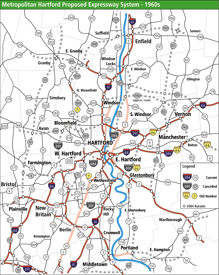 Looking at it, the Hartford area makes a lot more sense now. Look at all those cancelled projects. quote:Yeah, the ones at West Farms Mall certainly don't seem to be. They're sandwiched between a Red Robin and a row of trees, anyway. There's one at the Bridgeport City Hall. It's not solar powered either--it's a United Illuminating "courtesy" charger.
|
|
#
?
Mar 14, 2015 20:35
|
|


|
Kakairo posted:Ah, I thought the plan was full solar charging. Not good, then. You'd need one hell of a lot of solar panels to handle the load of charging a single car's battery direct from the sun, and quite a lot of battery on site to instead collect the power over time.
|
|
#
?
Mar 14, 2015 20:40
|
|

|
NihilismNow posted:Some of Tesla's Supercharger stations are partially solar powered. Nintendo Kid posted:You'd need one hell of a lot of solar panels to handle the load of charging a single car's battery direct from the sun, and quite a lot of battery on site to instead collect the power over time. Yup. With PV cells you're lucky if you can get 50W per m2. A Tesla model S has a 60kWh battery (that's the smaller battery option). Leaving out charging inefficiencies, Your 10m x 10m garage roof (this is being generous - that's a pretty big roof / PV array) would generate 5kW. With that, it would still take 12 hours of full-powered direct sunlight to charge the battery on the car. Oh, and you'll need to be charging your car during the day (or getting a second half-ton battery which you swap out every day). And this is all erring in favour of PV efficiency and generating ability. PV is great for low-power applications like lighting and computers, but it's pretty crap for really energy-intensive stuff like cooking or running cars.
|
|
#
?
Mar 14, 2015 21:03
|
|


|
wolrah posted:I started this post thinking I was going to back up this point with some numbers, but assuming I didn't make any stupid mistakes it doesn't look like this is true, at least as far as CO2 goes. Not quite, you didn't include the lifecycle analysis for gas. Pumping oil, transporting it, refining it, transporting gas, storing it and selling it are not exactly cheap or clean. Lead out in cuffs posted:You are awesome. Thank-you for doing the legwork on this. Transmission losses are not that much, about 6% according to the EIA.
|
|
#
?
Mar 14, 2015 21:40
|
|

|
Minenfeld! posted:Is this normal? it looks really elegant, but I've never seen a roundabout used that way. Yeah sure, it's pretty much the standard grade-separated interchange design on UK freeways.
|
|
#
?
Mar 14, 2015 22:04
|
|
|
Koesj posted:Yeah sure, it's pretty much the standard grade-separated interchange design on UK freeways. Which is frankly insane, incidentally.
|
|
#
?
Mar 14, 2015 22:10
|
|
|
Koesj posted:Yeah sure, it's pretty much the standard grade-separated interchange design on UK freeways. The UK generally has the roundabout go over on top of the main carriageway, though. See e.g. https://www.google.com/maps/place/53%C2%B012%2701.3%22N+2%C2%B023%2714.8%22W/@53.200352,-2.387443,354m/data=!3m2!1e3!4b1!4m2!3m1!1s0x0:0x0 That feels like it's probably smarter - leaving the motorway you want to be slowing down anyway, so the ramp helps you do it with less braking. EDIT: I imagine it's quieter, also. Fangz fucked around with this message at 22:30 on Mar 14, 2015 |
|
#
?
Mar 14, 2015 22:25
|
|


|
Minenfeld! posted:I found an interesting map the other day for the Hartford area: I think that map oversimplifies things a bit. Yes, some roads and interchanges were built in a way to connect into possible future roads. But some of those future roads really never got anywhere at all, just ideas in a planner's mind. They weren't exact cancelled, in my opinion.
|
|
#
?
Mar 14, 2015 22:48
|
|

|
Minenfeld! posted:Is this normal? it looks really elegant, but I've never seen a roundabout used that way. Only two of those freeways are, IMO, real holes, and that's the rest of 291 and 491. quote:I think that map oversimplifies things a bit. Yes, some roads and interchanges were built in a way to connect into possible future roads. But some of those future roads really never got anywhere at all, just ideas in a planner's mind. They weren't exact cancelled, in my opinion. There's scars of a lot of these freeways all over the area. 484, 284, 190, 189 (to planned 291), cancelled 84, all had fractions built in some way. There were legit plans and designs for things like the route 10 and route 20 extensions, even though they were unlikely to happen.
|
|
#
?
Mar 14, 2015 23:03
|
|

|
I'm not in favor of starting all the projects on the map. I just thought it was interesting how the current CT highway map makes a lot more sense when you can fill in all the blanks with the cancelled projects. Although, the strangest thing to me is still the on-again off-again 84 extension that was supposed to go to Providence.
|
|
#
?
Mar 15, 2015 02:47
|
|
|
Koesj posted:Ozymanidas This is a good post.
|
|
#
?
Mar 15, 2015 05:31
|
|

|
Malcolm XML posted:Not quite, you didn't include the lifecycle analysis for gas. Pumping oil, transporting it, refining it, transporting gas, storing it and selling it are not exactly cheap or clean. Also, the distribution of teslas and power generation. In CA, where the most teslas have been sold so far, 0.51% of power comes from coal in state and 7% including out of state (smaller than wind). Coal in general is being phased out due to very cheap natural gas and i suspect almost no where has a near 100% coal powered grid except maybe wv.
|
|
#
?
Mar 15, 2015 08:33
|
|

|
Minenfeld! posted:I'm not in favor of starting all the projects on the map. I just thought it was interesting how the current CT highway map makes a lot more sense when you can fill in all the blanks with the cancelled projects. Although, the strangest thing to me is still the on-again off-again 84 extension that was supposed to go to Providence. Yeah, that was my biggest surprise when I started working on the Aetna Viaduct. It seems like a terrific mess with weird grade separations, ramps to nowhere, rapidly changing shoulder widths, lane drops, bottlenecks, and tight curves. But once I got the original design plans, and got a chance to look through the site constraints and elevations, everything began to make a LOT more sense. There aren't just canceled freeways every two exits, there were also canceled ramps that were in the original plans but crossed out in change orders. The original planning volumes absolutely justified the lane arrangement they ended up using. And they were doing the best they could to minimize property impacts and maintain local road connectivity, hence the narrow shoulders and roller-coaster vertical geometry. Using 1950s design standards, they did an incredible job. It's not their fault that the standards have changed so much in the intervening 60 years. We made an even more comprehensive canceled freeway map as part of the Needs and Deficiencies study. Kurumi only shows the freeways that were still on the table in the 1960s; there were some that were proposed later, or canceled before. They never planned to build ALL of them; it was more of a shotgun approach. Unfortunately, that didn't turn out very well, and we're stuck with what we have now.
|
|
#
?
Mar 15, 2015 14:53
|
|
|
As promised, a somewhat more comprehensive canceled freeway map (still doesn't include all of them, as that would make it hopelessly cluttered): ----- Aaaaand some words about traffic engineering: The job of any traffic engineer is to move goods and people safely and efficiently. In some cases, these two goals support each other: roads with high overall speeds, low speed differentials, and forgiving design elements such as grassy medians and wide shoulders tend to improve both safety and efficiency. Driverless cars and congestion mitigation are other causes that achieve both goals. There are two cases where things get sticky, though. First, we are often faced with a conflict between safety and efficiency, and some compromise must be made. Second, our decisions affect everyone, not just road users, and have secondary effects that can be difficult to quantify. A classic case of safety conflicting with efficiency is a simple intersection. Without any traffic control at all, nobody ever has to stop, but crashes are frequent and severe. On the other side of the spectrum, putting in an all-way stop imposes needless delay (and the attendant increases in emissions and waste of fuel), even as it reduces the crash rate. The solution to this problem is a compromise between safety and efficiency. Keep in mind that efficiency includes cost-efficiency; while it may be ideal to grade-separate every single intersection, or build roundabouts at every crossing, these aren�t necessarily a good use of money that could be better used in other projects. As with any compromise, there are going to be people on both sides of the issue who feel wronged. One constant source of pressure comes from the goods-moving industry, which is looking to double its throughput by 2050. They have seen congestion get worse and worse as road construction has all but stopped in the last 30 years. They carry multi-million-dollar loads of cargo, and every hour of delay is lost profit. The military, too, is looking to boost throughput; after all, they were a big reason for the construction of the Interstate network to begin with. Emergency responders and planning agencies like FEMA see great risk in congested evacuation routes. These are all concerns that traffic engineers need to address. For those more interested in safety, there is the issue of motor vehicle accidents. Although their rate has been gradually declining for the most part, some users (like bicyclists and pedestrians) are especially vulnerable in a collision. Safety advocates are interested in lowering overall speeds, or at least speed differentials. There are several ways to accomplish this, whether by lowering capacity, increasing enforcement, changing geometric elements, or restricting the class of user that can use a particular facility. Other safety advocates look for roadway improvements that significantly reduce accident rates: rumble strips, turn lanes, pedestrian signals, extra signage, median installation, and grade separation. These lobbies are no less powerful than those who push for efficiency. There are some groups with more complex agendas, supporting some combination of safety and efficiency as they strive to make their voices heard. Environmental agencies, politicians, neighborhood groups, bicycle advocates, and social equity activists all look for changes that will meet their needs. A new bridge may be designed wider to avoid impacts to a wetland, with decorative railings to match the historic character of a neighborhood, a bus shelter to serve a nearby nursing home, and a dedicated bicycle lane, and then named after a recently-deceased local celebrity so that the town�s senator can grab a few dozen more votes. As if this wasn�t all complicated enough already, we have to take into account the externalities and long-term impacts of our projects in a much broader context than we�re used to thinking. This is an especially big problem for engineers, as we are used to dealing with concrete equations, diagrams, and rules of thumb. How do we quantify the impact an overhead sign will have on the viewsheds of surrounding communities? Is it cost-effective to build small tunnels beneath a new road so that frogs and salamanders won�t get crushed during breeding season? Will eliminating a bottleneck result in significantly increased vehicular use that will exacerbate anthropogenic climate change? These are way, way outside our areas of expertise, and we typically look to other experts for guidance, or wait for new standards to be incorporated in our reference materials. Each traffic engineer will have his opinion about the current trends. Personally, I think we are too concerned with cost-effectiveness. Most politicians don�t seem to understand that the entire 21st-century way of life depends on fast movement of goods and ideas from coast to coast, and from continent to continent. They also seem to ignore the way that our transportation system has led to social shifts that isolate communities and economically disadvantage low-income families. I used to think that raising the gas tax would be a good way to ensure that everyone�s needs were addressed, but I�ve realized that the gas tax is a regressive tax, and it does not affect all users proportionally. If transportation were treated as a human right, with transit heavily subsidized and a progressive tax introduced, we could improve both safety and efficiency without having to make the same unsatisfying compromises we do today. Updated standards would be very helpful, as well; much of the existing design standards are based on anecdotal or outdated evidence. Clear, regularly updated guidance would ensure that engineers are working toward the same common goals. But hey, change is hard, right? It�s much easier to let our sidewalks crack, our schoolchildren be run over, and our bridges rot away.
|
|
#
?
Mar 16, 2015 22:07
|
|
|
Sounds like a giant clusterfuck from which it's miraculous anything gets done at all.
|
|
#
?
Mar 16, 2015 22:53
|
|


|
Cichlidae posted:The FHWA injected a tremendous amount of money into these programs, and gave extra bonus cash for "slum clearance." That should tell you pretty much everything you need to know.
|
|
#
?
Mar 17, 2015 00:40
|
|


|
Cichlidae posted:As promised, a somewhat more comprehensive canceled freeway map (still doesn't include all of them, as that would make it hopelessly cluttered): I wish you could publish that somewhere.
|
|
#
?
Mar 17, 2015 01:13
|
|

|
quote:Each traffic engineer will have his opinion about the current trends. Personally, I think we are too concerned with cost-effectiveness. Most politicians don�t seem to understand that the entire 21st-century way of life depends on fast movement of goods and ideas from coast to coast, and from continent to continent. They also seem to ignore the way that our transportation system has led to social shifts that isolate communities and economically disadvantage low-income families. I used to think that raising the gas tax would be a good way to ensure that everyone�s needs were addressed, but I�ve realized that the gas tax is a regressive tax, and it does not affect all users proportionally. If transportation were treated as a human right, with transit heavily subsidized and a progressive tax introduced, we could improve both safety and efficiency without having to make the same unsatisfying compromises we do today. Updated standards would be very helpful, as well; much of the existing design standards are based on anecdotal or outdated evidence. Clear, regularly updated guidance would ensure that engineers are working toward the same common goals. This is important enough to say twice. It's depressing how many people refuse to connect the dots to see the much larger picture. Although I feel that part of our federal structure and New England town-meeting style democracy affects a lot of this type of thinking. There's a lot of "not in my backyard!" when I talk to people about transportation and how it affects many people. Also, sweet map. Do you have others for the rest of the state? Or perhaps a place to look on the DOT website for these kinds of primary documents? A lot of what I can find and read is all from secondary sources like kurumi. And didn't the DOT just adopt new standards? The "complete streets" deal?
|
|
#
?
Mar 17, 2015 03:14
|
|
|
http://www.washingtonpost.com/blogs/govbeat/wp/2015/03/06/these-are-the-most-popular-street-names-in-every-state/ Top street names!
|
|
#
?
Mar 17, 2015 03:19
|
|


|
Minenfeld! posted:Also, sweet map. Do you have others for the rest of the state? Or perhaps a place to look on the DOT website for these kinds of primary documents? A lot of what I can find and read is all from secondary sources like kurumi. I only made a map for the Hartford area because that's the scope of my project. I used about a half-dozen primary and secondary sources, including some construction plans we found ") The DOT is constantly adopting new standards, but they are based more on political pressure than research. When the report came out that said "add left turn lanes everywhere if you want to save lives, for gently caress's sake, we've been doing it all wrong," the other engineers just kinda shrugged and said, "that'll make it hard for developers, and we'll get in trouble with politicians." That was the straw that broke the camel's back when I left the DOT.
|
|
#
?
Mar 17, 2015 04:03
|
|
|
Interesting way to make a place bus-only  Although in the US 79% of vehicles are super wide mega trucks or SUV's so probably won't work. Also lawsuits apparently due to our hosed legal system?
|
|
#
?
Mar 17, 2015 17:57
|
|
|
Yeah, I guess I haven't seen those in the USA. What I did see there was a strip of angled spikes so you could drive over that piece of road in only one direction. It scared me a bit. But those might've been on a private property parking, I'm not certain.
|
|
#
?
Mar 17, 2015 20:23
|
|

|
Carbon dioxide posted:Yeah, I guess I haven't seen those in the USA. What I did see there was a strip of angled spikes so you could drive over that piece of road in only one direction. It scared me a bit. But those might've been on a private property parking, I'm not certain. Lots of private property has those, especially for things like access onto airport runways/taxiways and roads that let you avoid a toll if you're going to a specific place.
|
|
#
?
Mar 17, 2015 20:30
|
|
|
I'm always scared when I drive over those things they'll shred my tires or they will come back up too early or something horrible.
|
|
#
?
Mar 17, 2015 21:02
|
|
|
 Houston really only has two cancelled freeways: The Harrisburg Freeway running from Downtown to the southeast side and the "Bay City" Freeway which was supposed to run from 610 down Post Oak Blvd to presumably Bay City, TX. (This was sort of built but not in the same location) The other two, the Hardy Toll Road extention and the Alvin Tollway, are still planned and will probably be built eventually as they go thru predominately industrial areas and have the ROW already acquired.  What if Houston had instead been like San Francisco or Boston and revolted in the 1960's to new freeway construction inside the city and turned Houston into the pinko hippie utopia it didnt turn into until the 2010's? Now, thru the magic of technology and half-assed Paint.NET techniques, I can show you just that! I followed two rules. 1) Freeways had to be Loop 610 or inside Loop 610. 2) Right of Way+frontage road acquisition had to be complete by the end of 1964. (The date of the 1964 San Francisco Trafficways Plan and protests) Segments of freeways that were under construction or ROW/frontage roads were complete were allowed to be completed*.  A few interesting things happen that arent readily apparent:
* The East Loop was not completed until the 70's but that area was almost completely industrial/port property or undeveloped at the time.
|
|
#
?
Mar 18, 2015 05:05
|
|
|
That's pretty cool, and if any historians wanted to do their cities I would enjoy reading about them, too. Question: you referred to "ghost" ramps an awful lot. I've read the entire thread, but that term isn't ringing a bell. What are those?
|
|
#
?
Mar 18, 2015 07:16
|
|
|
Grundulum posted:That's pretty cool, and if any historians wanted to do their cities I would enjoy reading about them, too. http://en.wikipedia.org/wiki/Highway_revolts#Vancouver Grundulum posted:Question: you referred to "ghost" ramps an awful lot. I've read the entire thread, but that term isn't ringing a bell. What are those? Stuff like this.
|
|
#
?
Mar 18, 2015 09:22
|
|
|
I passed this one a lot as a kid. It was always strange that there was grass growing on a little hill on a highway.
|
|
#
?
Mar 18, 2015 18:59
|
|

|
That's pretty inspiring that people all around there world were successfully fighting for their cities. Not always successfully, but imagine how bad things would be if the Moses' of the world had gone totally unopposed.
|
|
#
?
Mar 18, 2015 19:53
|
|
|
Are you familiar with http://www.houstonfreeways.com/ and Erik Slotboom's *free* book on the city's freeway system in pdf format there? It's so fantastic I cited it in some class papers back in the day. e: oh wow I'd never rechecked and now his Dallas/FW site has got a 541pp book as well 
Koesj fucked around with this message at 02:25 on Mar 19, 2015 |
|
#
?
Mar 19, 2015 02:22
|
|
|
Tampa Bay, Florida. The region where we built all the planned expressways as local roads. Green = expressways in operation (most of these either have or are planned to be getting HOT lanes) Yellow = built as arterial, upgraded with grade separation Orange = built as arterial Red = planned but killed by political opposition (either cost or location) On this map are what would have been the full versions of I-175 (Pinellas Trail alignment to Clearwater) and I-375 (49th St/Bayside Bridge/McMullen Booth to Pasco County), which only exist in the form of stubs in downtown St Petersburg. Grade separation is now the order of the day for most of the orange lines that were built as arterials instead of expressways, as light cycles already give 4+ mins of green time and that still isn't enough to keep traffic moving during rush hour.  Here's the region's passenger rail map:  It's a joke. Aside from Amtrak Silver Service and a Heritage Streetcar that doesn't run morning service, we have none. Varance fucked around with this message at 03:42 on Mar 19, 2015 |
|
#
?
Mar 19, 2015 02:36
|
|

|
Koesj posted:Are you familiar with http://www.houstonfreeways.com/ and Erik Slotboom's *free* book on the city's freeway system in pdf format there? It's so fantastic I cited it in some class papers back in the day. That, and historicaerials.com, was my main resource. I thought about doing one for Dallas as well but the only freeway's that werent complete in Dallas by 1964 were the 45/345 freeway thru downtown and Woodall Rogers. To be honest though, in every conceivable way, Houston was destined to be a car-centric city and none of those freeways ever had a shot at cancellation no matter how much protest there was. 75% of the residents of the neighborhood the I-10 went through where happy the freeway was there after it was built. I personally think the protests for the Harrisburg Frwy were less a factor of cancellation than the fact that the state ran out of money and the I-45 expansion had basically done the job of the Harrisburg anyway. The Bay City freeway was killed because the city grew to fast ahead of it. Retail, expensive homes, and high-end (at the time) apartments were built in the path of the right -of-way and developers carried a ton of political clout (and still do.) Ron Pauls Friend fucked around with this message at 03:20 on Mar 19, 2015 |
|
#
?
Mar 19, 2015 03:17
|
|
|
The annoying thing for some regions/cities is that often a true map of all the things that weren't built includes mutually exclusive plans. For example, the current route of I-476 outside Philadelphia from the PA Turnpike to I-95, was the "blue alternative" (hence why people still call it the Blue Route), but I've seen maps of canceled Philly-area freeways that draw all of the other proposed alignments at once, when that was never going to be done,
|
|
#
?
Mar 19, 2015 03:26
|
|
|
Well I was referred here by a friendly goon who said this highway interchange was "an interchange design with insane amount of potential throughput. What fucks it up is the city generating an insane amount x2 in traffic. Busiest road on earth." Could anyone explain that a bit more to me as I often have the convo with friends and family about the poor design of the interchange or lack of forward planning heavy traffic. But mostly I'm wondering why they made 6 lanes eventually merge into 3 over a roughly 600m-700m stretch from North to South.
|
|
#
?
Mar 19, 2015 03:45
|
|

|
Oooooerrr, great planning disasters! I did a quantitative comparison between freeway networks in the three major polycentric NW-European metropolitan areas for my master's thesis, and the amount of cancelled plans doesn't seem to correlate too much with measured congestion in 2005. orange=nasty, red=worse, dashed lines are cancelled freeways, solid grey ones were planned/upgradeable in '05 Randstad, Netherlands  Rhein-Ruhr, Germany  Also illustrator ate my fonts 
|
|
#
?
Mar 19, 2015 04:46
|
|
|

|
| # ? May 9, 2024 23:37 |
|
|
Baronjutter posted:That's pretty inspiring that people all around there world were successfully fighting for their cities. Not always successfully, but imagine how bad things would be if the Moses' of the world had gone totally unopposed. What's interesting is to look at historical plans for Vancouver and compare them to the map today. It wasn't just freeways. They wanted major streets every few blocks. In fact, these maps go a long way towards explaining things like why some quiet residential streets are wide enough for four cars (Hudson, for example). I think it's honestly a good thing they didn't get their way.  
|
|
#
?
Mar 19, 2015 05:07
|
|