


|
Interesting that you appear to be able to see the old border between the GDR and DDR.
|
 #
?
Feb 28, 2019 12:37
#
?
Feb 28, 2019 12:37
|
|


|

|
| # ? Jun 7, 2024 09:35 |
|
|
Jippa posted:Also there are too many people in england we are going to sink. We�re working on it though! All those heavy bankers gonna be noping out soon, along with half the staff of the nhs
|
|
#
?
Feb 28, 2019 13:01
|
|
|
catfry posted:Interesting that you appear to be able to see the old border between the GDR and DDR. Ehhhhh, Saxony is pretty dense.
|
|
#
?
Feb 28, 2019 13:23
|
|
|

|
|
#
?
Feb 28, 2019 13:58
|
|

|
Kennel posted:bit larger scale You can literally make out the valleys through the Alps on that one, thats cool. The pre-WW2 German land that is now Polish also appears noticeably lower population density than the rest of Poland, interestingly.
|
|
#
?
Feb 28, 2019 14:08
|
|

|
Ardennes posted:Ehhhhh, Saxony is pretty dense. true enough, it doesn't really fit as well as I thought, especially looking at the higher detail map 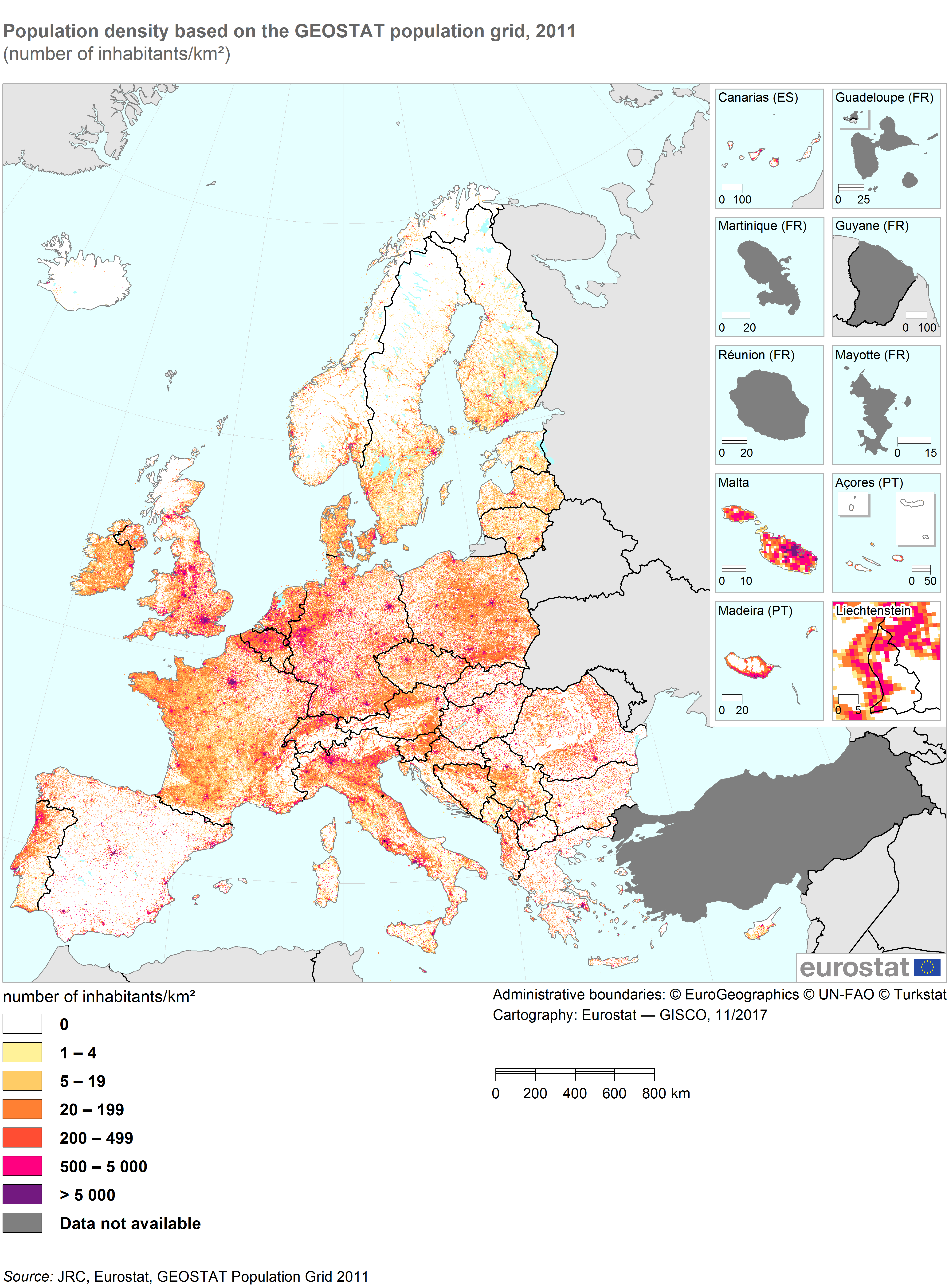 . .Blut posted:The pre-WW2 German land that is now Polish also appears noticeably lower population density than the rest of Poland, interestingly. It is kind of funny that all countryside in a 200 km radius from Berlin is noticeably lowered in population, also in Poland. I have no idea why though. It does somewhat conform to old prussian borders. catfry fucked around with this message at 14:44 on Feb 28, 2019 |
|
#
?
Feb 28, 2019 14:31
|
|
|
Blut posted:The pre-WW2 German land that is now Polish also appears noticeably lower population density than the rest of Poland, interestingly. 
|
|
#
?
Feb 28, 2019 14:56
|
|

|
FreudianSlippers posted:Most Spaghetti Westerns were filmed in Spanish deserts. Shouldn't they be like... Paella Westerns then?
|
|
#
?
Feb 28, 2019 15:29
|
|
|
Golbez posted:That feels really inspiring for some reason. Yeah, I really enjoyed Eagle-map. The straight is 19km wide at its widest point, so using Pythagoras and a quick google search that says eagles can fly at 10,000 feet, an eagle should be able to see 19.23km from that height, meaning that yes, Mr. Eagle could see the other side.
|
|
#
?
Feb 28, 2019 15:38
|
|

|
Wallonia and Flanders: the Map. Seriously though, it's shocking how densely populated Flanders is.
|
|
#
?
Feb 28, 2019 15:44
|
|

|
Btw Bradenberg historically had a very low population density, probably because much of it is reclaimed marshland. This includes before the war btw.
|
|
#
?
Feb 28, 2019 15:47
|
|
|
Pook Good Mook posted:Wallonia and Flanders: the Map. we're pretty much suburbia: the map.
|
|
#
?
Feb 28, 2019 15:52
|
|

|
Yeah BB being sparse has little to do with the DDR, always been like that. Similarly Meck-Pomms interior is mostly woodland, Moors and lakes.
|
|
#
?
Feb 28, 2019 16:05
|
|

|
double nine posted:we're pretty much suburbia: the map. Yes, unlike most other places there is no stark rural/urban division in Flanders. There are only a few proper cities (especially since Brussels isn't part of the Flemish Region), the rest is just endless suburban allotments. It's an absolute monstrosity in terms of environmental impact and efficiency, but it does give us a nice uniform color on these maps, there's that at least
|
|
#
?
Feb 28, 2019 16:19
|
|


|
Golbez posted:I will never not be surprised at how empty Spain is. Most of it is less populated than the Alps. Greece and Spain are both very dry countries in large part, Italy is the odd duck out of the trio in being more fertile generally (I'm surprised by how populated the Appenines are) As someone who has been there, North Cyprus is definitely definitely nowhere near that empty, so they definitely didn't survey it. Which is too bad because it is definitely sharply underpopulated compared to the south and the comparison would have looked interesting. It would have been "ethnic cleansing.jpg". Also as someone who has also been around the perimeter of Iceland, it definitely IS that empty. Grape fucked around with this message at 17:00 on Feb 28, 2019 |
|
#
?
Feb 28, 2019 16:53
|
|

|
Saladman posted:Also it looks like northern Cyprus is not surveyed. It is densely populated. Nah I wouldn't say densely outside of a few places. We're talking an island where the ethnic group that makes up 80% of the population was killed/chased/scared out of the north. And then the other ethnic notable group of like 15% of the population was likewise concentrated into that north. It oozes this feeling of being a rump state in some areas, particularly Famagusta. The artificiality of it is impossible to not notice. Whereas in the south, if you were a space alien who knew nothing about any of the local history and goings on, you could walk around their cities and wouldn't know something was up until you hit the Green Line in the capital. Grape fucked around with this message at 17:02 on Feb 28, 2019 |
|
#
?
Feb 28, 2019 16:57
|
|
|
catfry posted:true enough, it doesn't really fit as well as I thought, especially looking at the higher detail map Sloppy map. They always forget about Saint Martin.
|
|
#
?
Feb 28, 2019 18:18
|
|
|
Golbez posted:I will never not be surprised at how empty Spain is. Most of it is less populated than the Alps. The map is a bit deceiving though. The population density of Spain is 92 people/km� and that of France is 116 (118 if you only count France m�tropolitaine) whereas the map makes it look like France is much more densely populated.
|
|
#
?
Feb 28, 2019 19:02
|
|

|
duckmaster posted:Sloppy map. They always forget about Saint Martin. But it does have Lichtenstein for some reason.
|
|
#
?
Mar 1, 2019 00:06
|
|
|
I never realized how populated south eastern Bavaria is. I always assumed it would be its densest in the Munich-Landshut-Ingolstadt triangle.
|
|
#
?
Mar 1, 2019 07:32
|
|

|
cebrail posted:The map is a bit deceiving though. The population density of Spain is 92 people/km� and that of France is 116 (118 if you only count France m�tropolitaine) whereas the map makes it look like France is much more densely populated. Yeah, but population density over a whole country can be misleading as well. Like, Egypt in numbers has a fairly average population density -- but in practice on the ground its population density is the highest in the world for any real country (sorry Singapore, Monaco) given that the inhabited part of Egypt is about 5 miles wide and 900 miles long + the delta + the coasts. The massive wasteland is almost entirely irrelevant to any measure of population density, barring massive public works projects like the Farafra Oasis (man-made in ancient times, iirc around 2000 BC) or Wadi El Rayan (man-made in the 1960s). I guess they could do the same with the Qattara depression if desalination technology improves by an order of magnitude. Saladman fucked around with this message at 09:23 on Mar 1, 2019 |
|
#
?
Mar 1, 2019 09:20
|
|
|
Blut posted:The pre-WW2 German land that is now Polish also appears noticeably lower population density than the rest of Poland, interestingly. Adding to the fact that, like somebody said, it always had a lower population density, a lot of Germand were kicked out of that land after the war, which didnt help in terms of density.
|
|
#
?
Mar 1, 2019 15:31
|
|
|
Epicurius posted:Adding to the fact that, like somebody said, it always had a lower population density, a lot of Germand were kicked out of that land after the war, which didnt help in terms of density. Turns out three forced diasporas/displacements in a 10 year period followed by 50 years of Soviet-style communism isn't something you come back from quickly. Like you can straight up see the borders of pre-1919 Germany in Poland. Wild.
|
|
#
?
Mar 1, 2019 18:01
|
|
|
Ethnic cleansing.jpg strikes again
|
|
#
?
Mar 1, 2019 18:30
|
|
|
But as cebrail points out, it is easy to be mislead about the actual number og people in a region by looking at the colours. It might be that the organization of humans is more concentrated in villages and cities, separated by more empty countryside. This leads to a more whitish appearance, like Spain or Hungary. In contrast the Polish countryside is full of very small lots, each with it's own house, there is very few sqkm where noone lives, despite this, the overall density is similar to hungary. Actually, I have a theory related to this, about the difference between old prussian land and i guess old tzsarist russian land, in that the inheritance rules where different, eldest inherits, vs gavelkind, (land is split between children). This led to smaller and smaller lots in Poland compared to prussia, and eventually to the differences in human distribution today. I'n not sure about all the mechanisms but if where to write a paper on demographic changes I'd like to think it would be interesting. catfry fucked around with this message at 19:38 on Mar 1, 2019 |
|
#
?
Mar 1, 2019 19:25
|
|
|
I dunno about pre-1919 Poland, but Germany east of the Elbe river and especially the Prussian provinces of Pomerania, Western/Eastern Prussia and Posen were kinda infamous for being heavily dominated by the �Junker� social class, ie mostly minor nobility that owned huge tracts of land in the east, centred around the Junker�s manor and normally a small village supporting the manor.
|
|
#
?
Mar 1, 2019 20:07
|
|


|
I also notice that Alsace-Lorraine seems to be patterned more like Germany than like France or Poland, suggesting that the cause of the difference could predate the 20th century...although I'm not familiar enough with the region to know whether there could be another explanation. It's not as obvious as the Prussia border, at least.
|
|
#
?
Mar 1, 2019 20:32
|
|

|
So, I was given this book as a gift recently and I heartily recommend it to this thread.
|
|
#
?
Mar 1, 2019 21:43
|
|


|
SurgicalOntologist posted:I also notice that Alsace-Lorraine seems to be patterned more like Germany than like France or Poland, suggesting that the cause of the difference could predate the 20th century...although I'm not familiar enough with the region to know whether there could be another explanation. It's not as obvious as the Prussia border, at least. Well, here's how local dominant languages looked in the mid-19th century, in that part of Alsace and Lorraine that was annexed from France in 1871 following the war, and from data taken before France made a major push to move regional speakers to Parisian France.  It's probably a good proxy for what sections had been under what general cultural influence (keeping in mind that the region had been progressively taken from HRE control by the kings of France over about a century starting in 1660. (With Alsace being taken first in that process)
|
|
#
?
Mar 1, 2019 21:59
|
|

|
All the Germans that were in what is now Western Poland were kicked out and replaced with the Poles that had been in what is now Western Belarus, I wouldn't be surprised if there had been more Germans than there were Poles replacing them.
|
|
#
?
Mar 1, 2019 22:04
|
|
|
reignonyourparade posted:All the Germans that were in what is now Western Poland were kicked out and replaced with the Poles that had been in what is now Western Belarus, I wouldn't be surprised if there had been more Germans than there were Poles replacing them. And that's after the Germans kicked out any Poles that were there in 1939-40. And minus any Jews.
|
|
#
?
Mar 1, 2019 23:34
|
|
|
analogy6 posted:
This is amazing, is it legit?
|
|
#
?
Mar 2, 2019 00:27
|
|


|
What's with northern Portugal? It doesn't seem like it should be very different from Galicia, but it looks denser than anywhere else in the Iberian peninsula.
|
|
#
?
Mar 2, 2019 04:53
|
|
|
James Garfield posted:What's with northern Portugal? It doesn't seem like it should be very different from Galicia, but it looks denser than anywhere else in the Iberian peninsula. Isn't that a good stretch of pretty decent farmland that leads to many spread out small-medium towns? That'll bring a lot of spread out population versus empty Spanish plains dotted with medium-large towns and small cities.
|
|
#
?
Mar 2, 2019 05:23
|
|
|
James Garfield posted:What's with northern Portugal? It doesn't seem like it should be very different from Galicia, but it looks denser than anywhere else in the Iberian peninsula. Costa Verde as opposed to the more mountainous north?
|
|
#
?
Mar 2, 2019 12:41
|
|
|
That's the core area of Portugal around Porto, conquered very early during the Reconquista. Apparently it's good land.
|
|
#
?
Mar 2, 2019 14:40
|
|
|
double nine posted:spain is really dry, which makes it kind of hard to live away from water sources. I do wonder what the place looked like before the christian dogs destroyed all the irrigation systems the muslims and before them the romans had set up. I had to find the map I posted when this exact same discussion came up five years ago but this is what Spanish (at least in the Crown of Castile) population density looked like in the late sixteenth century:  You'll note that the most dense parts have almost inverted from Old Castile to the coasts and obviously Madrid as well. The other large areas of land that remain sparsely populated were never particularly dense and then never became dense due to the economic forces at play that favored pasture and, later, urban areas as well as the demographic disasters of disease and war.
|
|
#
?
Mar 2, 2019 18:48
|
|


|
How the Canadian Revenue Agency defines "The North" The top red line represents the cut off for northern zones for tax deductions, with yellow areas being the cutoffs for intermediate zones.
|
|
#
?
Mar 2, 2019 20:30
|
|

|
As a follow-up to Venus, here's good ol' reliable Mars There are a few more interesting tourist sites here than on Venus, so I've marked a few on the map. Downside is, a lot of the historical ones are now underwater, but at least the mountaineering on Mars is really something. Pity a lot of the probes and landers opted for what is now just the wrong side of "beachfront" property.  1: Opportunity 2: Viking Lander 1 3: Mars Pathfinder 4: Spirit 5: Viking Lander 2 6: Matt Damon 7: Olympus Mons (tallest mountain on Mars, second tallest in the solar system after Vesta's Rheasilvia) 8: Mariner Valley 9: Elysium Mons Mars has the unusual property of its Northern hemisphere being almost universally lower than its Southern by about 20km, hence the great big ocean. I've no doubt that, after a while, a lot of the diddly crater lakes are going to end up changing shape from erosion, too. Now I have a weird urge to play Alpha Centauri.
|
|
#
?
Mar 2, 2019 23:02
|
|

|

|
| # ? Jun 7, 2024 09:35 |
|
|
The Venus and Mars talk reminded me of this page of various alternate earths and terraformed planets with maps, speculative climate and vegetation and stuff. http://www.worlddreambank.org/M/MRZ.HTM  http://www.worlddreambank.org/V/VENUS.HTM
|
|
#
?
Mar 2, 2019 23:47
|
|