


|
So I guess there�s basically no japanese people in Japan.
|
 #
?
Aug 20, 2019 04:53
#
?
Aug 20, 2019 04:53
|
|


|

|
| # ? Jun 7, 2024 18:52 |
|
|
A classroom globe in Korea. Hm, wonder what this sticker is about. Peel that poo poo. 
|
|
#
?
Aug 20, 2019 05:46
|
|


|
Lycus posted:No one noticed dinky South America? I think it's still making out better than tiny Africa.
|
|
#
?
Aug 20, 2019 05:47
|
|

 Yes, it's like a lava lamp.
|
India: approximately the size of Africa.
|
|
#
?
Aug 20, 2019 05:51
|
|

|
Zohar posted:The map NASA doesn't want you to see Big Korea Energy
|
|
#
?
Aug 20, 2019 06:44
|
|


|
 legend
|
|
#
?
Aug 20, 2019 06:45
|
|
|
Ah yes, the Sotadic Zone, definitely a rigorous scientific concept
|
|
#
?
Aug 20, 2019 07:13
|
|


|
Doesn't include the UK, disproven, next please
|
|
#
?
Aug 20, 2019 07:27
|
|


|
steinrokkan posted:Doesn't include the UK, disproven, next please A guy with a biography like this isn�t going to include his own island: quote:Sir Richard Francis Burton KCMG FRGS (/ˈbɜːrtən/; 19 March 1821 � 20 October 1890) was a British explorer, geographer, translator, writer, soldier, orientalist, cartographer, ethnologist, spy, linguist, poet, fencer, and diplomat.
|
|
#
?
Aug 20, 2019 08:03
|
|
|
the huge Korea map is sized for, what, how many Koreans live in each area?
|
|
#
?
Aug 20, 2019 08:19
|
|

|
Peanut Butler posted:the huge Korea map is sized for, what, how many Koreans live in each area? Yes. But what I don�t understand is why it turned most of the rest of the world into a desert, like even India is colored a desert yellow.
|
|
#
?
Aug 20, 2019 09:24
|
|
|
Platystemon posted:A guy with a biography like this isn’t going to include his own island: Ah, so it was less of a map and more of an itinerary.
|
|
#
?
Aug 20, 2019 09:34
|
|
|
Do you guys not know who Burton or what his deal was lol
|
|
#
?
Aug 20, 2019 09:39
|
|

|
 NO2 forecast for the next few days.
|
|
#
?
Aug 20, 2019 09:44
|
|

|
Ras Het posted:Do you guys not know who Burton or what his deal was lol Is he that Sir Forginton Sexbeard guy? e: After a quick BIS: amazingly enough (considering his beard and ways) not the Sir Forginton Sexbeard I was thinking of  ee: Yeah I conflated him with Sir Edmund Backhouse. 3D Megadoodoo fucked around with this message at 10:38 on Aug 20, 2019 |
|
#
?
Aug 20, 2019 10:32
|
|

|
Saladman posted:Yes. But what I don’t understand is why it turned most of the rest of the world into a desert, like even India is colored a desert yellow. Korea is the only place on Earth with seasons after all
|
|
#
?
Aug 20, 2019 12:07
|
|


|
Honj Steak posted:
It's really fascinating how you can see the most important shipping lanes too. Does anybody know what's up with those scattered NO� hotspots in Siberia and the two very consistent ones in southern Alaska?
|
|
#
?
Aug 20, 2019 12:44
|
|


|
System Metternich posted:It's really fascinating how you can see the most important shipping lanes too. Does anybody know what's up with those scattered NO� hotspots in Siberia and the two very consistent ones in southern Alaska? Yeah, those are the centers for :redacted by the Illuminati:.
|
|
#
?
Aug 20, 2019 13:02
|
|
|
System Metternich posted:It's really fascinating how you can see the most important shipping lanes too. Does anybody know what's up with those scattered NO� hotspots in Siberia and the two very consistent ones in southern Alaska? Wildfires
|
|
#
?
Aug 20, 2019 13:24
|
|


|
If you had a general map of particles in the air, Siberia would light up like a Christmas tree. The fire raging there is insane.
|
|
#
?
Aug 20, 2019 13:29
|
|


|
Like so?
|
|
#
?
Aug 20, 2019 13:43
|
|


|
Yup.
|
|
#
?
Aug 20, 2019 13:45
|
|
|
steinrokkan posted:Doesn't include the UK, disproven, next please
|
|
#
?
Aug 21, 2019 06:03
|
|


|
From 1907 You'll probably have to open in a new tab to read the text
|
|
#
?
Aug 21, 2019 07:57
|
|

|
The easiest way to quickly visually estimate how distorted a map is is to compare the island of Great Britain with Nigeria. Great Britain actually could fit inside Nigeria north to south, the whole thing.
|
|
#
?
Aug 21, 2019 15:09
|
|

|
A Buttery Pastry posted:I appreciate how this post told me with 100% certainty what the map was about. Britain has one of the strongest brands in the world. Wait, what? Strongest brands? He was referring to the pederasty map and making a joke, I thought? Britain was not exactly a hotspot for pederasty in 1850. Teriyaki Hairpiece posted:The easiest way to quickly visually estimate how distorted a map is is to compare the island of Great Britain with Nigeria. Great Britain actually could fit inside Nigeria north to south, the whole thing. That's kind of a strange comparison for anyone who is not British-Nigerian. If you're going to compare it to something equatorial, then why not Republic of Congo? Then they're the same shape too. Also related, this has probably come up before in the thread, but: https://thetruesize.com/ is a really cool site for doing exactly that. Unfortunately it doesn't let you rotate or mirror countries. Also despite map distortion, I get the impression most people think that Great Britain is much smaller than it actually is. On travel forums I see all the time people who think it's reasonable to like, drive from London to Edinburgh for a weekend of sightseeing. Saladman fucked around with this message at 16:25 on Aug 21, 2019 |
|
#
?
Aug 21, 2019 16:15
|
|
|
I mean I've done longer drives than that for long weekend trips. Probably helps if you're used to North American distances.
|
|
#
?
Aug 21, 2019 16:54
|
|
|
It�s a what, seven hour drive? Perfectly acceptable for a weekend if you can leave London on Friday after lunch. We would go shopping for clothes to Trieste from Yugoslavia. My dad would drive seven hours each way on terrible roads. In a 750cc engined, Serbian made, Fiat licensed car. We would leave around three am and return on the same day. NBD
|
|
#
?
Aug 21, 2019 17:08
|
|


|
PittTheElder posted:I mean I've done longer drives than that for long weekend trips. Probably helps if you're used to North American distances. Yeah it�s only like 7 hours. Take Friday afternoon off work, arrive in the evening, do stuff all Saturday and Sunday morning, leave Sunday afternoon or time it with a Monday holiday for a more relaxed trip. It�s a bit rushed but not too far out if you have something particular to do like a conference.
|
|
#
?
Aug 21, 2019 17:08
|
|

|
The Great Britain Nigeria thing is an easy comparison because they're nearly the same longitude. Look at Great Britain, move your eyes down a little to Nigeria. The larger Great Britain is on the map north to south compared to Nigeria, the more distorted the map is. It's simple and easy.
|
|
#
?
Aug 21, 2019 17:14
|
|
|
PittTheElder posted:I mean I've done longer drives than that for long weekend trips. Probably helps if you're used to North American distances. Outside of small stateland though... that seems really long and terrible to me. 
|
|
#
?
Aug 21, 2019 17:28
|
|

|
Saladman posted:Wait, what? Strongest brands? He was referring to the pederasty map and making a joke, I thought? Britain was not exactly a hotspot for pederasty in 1850.
|
|
#
?
Aug 21, 2019 17:39
|
|
|
Grape posted:Outside of small stateland though... that seems really long and terrible to me. Well the particular drive I'm thinking of is Calgary to Penticton, right through the heart of the Rockies, and it kind of owns. I've also done some long rear end drives through say, southern Utah. Never again.
|
|
#
?
Aug 21, 2019 17:55
|
|
|
Teriyaki Hairpiece posted:The Great Britain Nigeria thing is an easy comparison because they're nearly the same longitude. Look at Great Britain, move your eyes down a little to Nigeria. The larger Great Britain is on the map north to south compared to Nigeria, the more distorted the map is. It's simple and easy. I like this post because being able to scan your eyes south from Britain to Nigeria actually highlights how LITTLE distorted a map is, at least in terms of one variable. In order for this to work a map must have minimal angular distortion, otherwise, your eyes would not find Nigeria at all. All map projections involve the distortion of three properties: Angle, distance, and area. A map can preserve only one at the same time. This Britain-Nigeria comparison works on a Mercator, designed for navigation, because it minimizes angular distortion by sacrificing area. However without the lines of longitude for reference you might have a hard time making this comparison with a Dymaxion, which projects the earth onto an unfurled dodecahedron and when laid flat does not preserve direction or angle despite preserving area. example of a terrible map with the Dymaxion projection: 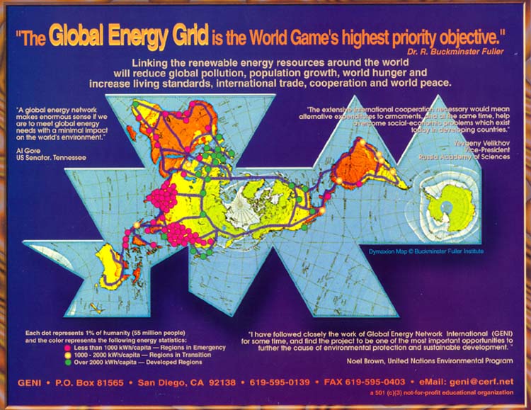
|
|
#
?
Aug 21, 2019 18:01
|
|
|
This page has a bunch of odd maps of New York 3D models of contemporary Manhattan overlaid on an old map of the city  Where the rich guys in the city are.  An 1885 map of "Beerdom" in the 11th Ward in lower Manhattan was published by the Christian Union newspaper, along with an article lamenting the fact that in this one neighborhood which was surveyed by temperance supporters, there were only 19 churches and synagogues, but over 340 saloons, catering to the mostly German population, who, according to the article, used to drink themselves blind every night.  Sitcom map of the city
|
|
#
?
Aug 21, 2019 18:11
|
|

|
PittTheElder posted:I've also done some long rear end drives through say, southern Utah. Never again. But southern Utah is gorgeous?
|
|
#
?
Aug 21, 2019 18:20
|
|


|
The worst drive is cetral Nebraska to the midwest or vice versa.
|
|
#
?
Aug 21, 2019 18:38
|
|
|
dublish posted:But southern Utah is gorgeous? In my experience it was the least interesting part of the Rockies I'd ever seen, just miles and miles of watching sage brush and low hills go by. Edgar Allen Ho posted:The worst drive is cetral Nebraska to the midwest or vice versa. Yeah the Canadian prairies are the same way. God damned Saskatchewan. And really south eastern Alberta for that matter. My favorite road game is to look around and find the places where you can see no trees at all (and often no clouds either). e: VVV picked a random spot on the way to a campground I actually like, looks almost exactly the same https://www.google.ca/maps/@50.2078794,-110.2844174,3a,85.2y,215.34h,82.02t/data=!3m6!1e1!3m4!1sKRNvvq3JsuEYyeluUSKxNA!2e0!7i13312!8i6656 PittTheElder fucked around with this message at 19:13 on Aug 21, 2019 |
|
#
?
Aug 21, 2019 19:05
|
|
|
Edgar Allen Ho posted:The worst drive is cetral Nebraska to the midwest or vice versa. *picks a random road in central Nebraska on Streetview*  While that looks like an absolutely horrible drive for anything that's longer than like half an hour, it's not as flat as I expected tbh. That's the road from Tryon to Mullen in Hooker County (  ), btw ), btw
|
|
#
?
Aug 21, 2019 19:08
|
|
|

|
| # ? Jun 7, 2024 18:52 |
|
|
I drove home from a job in Las Vegas once, heading back east. On the way there I took the southern route and home was I-70. It's loving amazing until you pass Denver, and then... there is literally nothing at all to see until eastern Missouri. It's incredible. Was one highlight though, I was in nowhere Kansas at night and good lord was that sky gorgeous. No light pollution to be seen.
|
|
#
?
Aug 21, 2019 19:14
|
|