


|
I live in Seattle and do most of my hiking (and snowshoeing) in the Cascades. 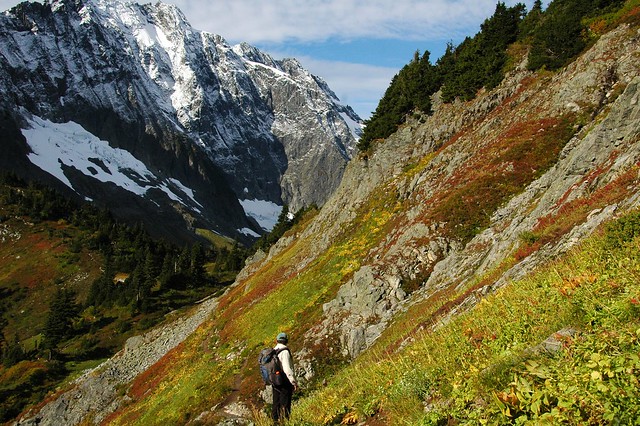 Climbing up to Sahale Arm by seanexmachina, on Flickr However, work is sending me to Miami for three months starting in January. Although I'm familiar with the joys of hiking in hot, humid places, I've never been to Florida. So: what are some good places to hike in South Florida? What are the general precautions I should take in the Everglades/Keys? Would I be better off just taking up cycling or kayaking instead?
|
 #
¿
Dec 22, 2012 01:42
#
¿
Dec 22, 2012 01:42
|
|

|

|
| # ¿ May 4, 2024 06:38 |
|
|
I am back from Florida, where the closest I came to a serious hike was looking at the sky and saying "today would be a really bad day to hike the Wild Persimmon Trail". Now I'm planning a trip to Idaho and Montana the week before Memorial Day. Where do Inland Northwest Goons like to hike in late May? We are going to Spokane, Missoula and maybe Sun Valley. I am familiar with Spokane and Northern Idaho but have no useful knowledge of Western Montana or Southern Idaho. Does Glacier have anything to offer this time of year?
|
|
#
¿
May 7, 2013 06:39
|
|
|
Econosaurus posted:I don't have PMs, so I cant message the DC goon in the OP. Any recommendations for places to hike/backpack in the DC area, preferably accessible by some mixture of public transport? I just moved here and would love to get out of the city for a weekend. You can get to the AT by taking MARC to Harpers Ferry. Weekdays only, though, so you'd have to head out on Friday night and get up really early on Monday morning (or just take a day off).
|
|
#
¿
Jun 13, 2013 02:04
|
|
|
This is probably the best time to visit Mt. Rainier. The snow is mostly gone from the trails and the wildflowers are at their peak. That's why I decided to hike the Wonderland Trail to Summerland and Panhandle Gap on Sunday. Summerland: 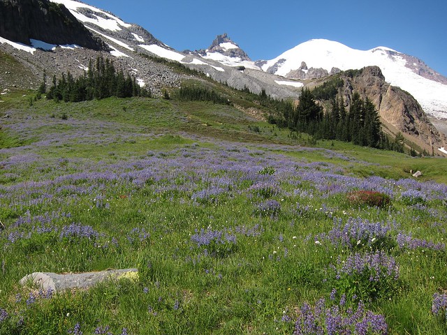 Panhandle Gap:  Above the vegetation zone: 
|
|
#
¿
Jul 30, 2013 05:24
|
|
|
I went to Ape Cave in college. Fun trip, especially since the Pacific Northwest has so few experiences like that. We then drove up to Windy Ridge in a 15-passenger van, which is not something I'd recommend if anyone in the van has ever gotten carsick before. Anyway, this weekend I hiked to Benchmark Mountain via West Cady Ridge. On a clear day, you can see just about every prominent peak in the Cascades between Rainier and Baker. There were more than enough huckleberries along the trail to make up for the fact that the flower show was over. 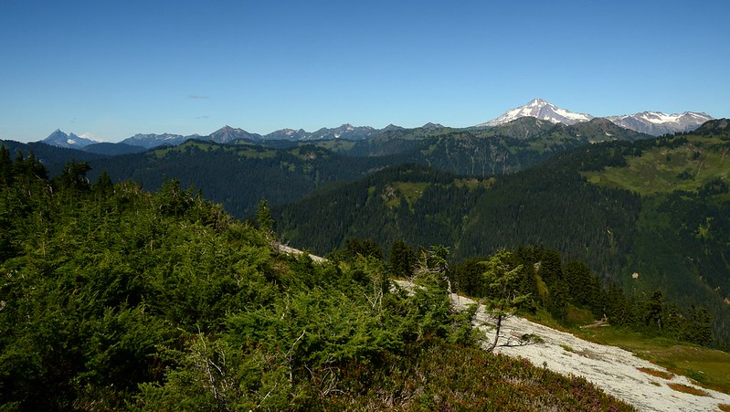 Benchmark Mountain north view by seanexmachina, on Flickr 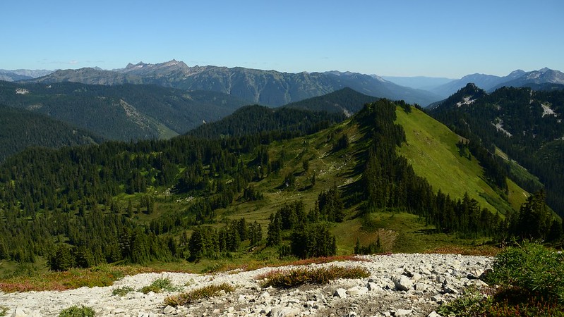 Benchmark Mountain east view by seanexmachina, on Flickr  Benchmark Mountain south view by seanexmachina, on Flickr  Benchmark Mountain west view by seanexmachina, on Flickr This is about as deep as you can get into the Henry M. Jackson Wilderness without having to spend the night. Hiking to places like this is really pushing me toward taking up backpacking.
|
|
#
¿
Sep 3, 2013 04:50
|
|
|
I hiked in Mt. Baker-Snoqualmie National Forest on Saturday. "Closed" just meant that they weren't servicing the trailheads (BYO toilet paper) or collecting parking fees. Forest roads aren't going to be gated unless they were already gated for some other reason but ranger stations and campgrounds are definitely closed.
|
|
#
¿
Oct 11, 2013 06:15
|
|
|
I have an REI gift certificate that I want to exchange for soft shell pants for snowshoeing and winter/wet-weather hiking (I'm in Seattle, so think drizzle rather than downpour). I was going to get the Arc'teryx Gamma LT pants, but REI says that they are out of stock online and in all the local stores. Does anybody have nice things to say about other soft shell pants?
|
|
#
¿
Jan 7, 2014 06:58
|
|
|
My girlfriend moved to Bellingham. Are there any day hikes in the Lower Mainland worth doing if you have to cross the border to get there or should we just wait for the trails around Mt. Baker to melt out? It sounds like all the best stuff involves driving most of the way to Whistler, which is an ordeal if you have to drive all the way through Vancouver first.
|
|
#
¿
Jul 15, 2014 03:14
|
|
|
Elk Mountain is only about 60 miles from Bellingham, so it is likely I'll make it up there sooner or later this summer. Although I own a copy of 103 Hikes in Southwestern British Columbia, sometimes I feel like it's effectively 33 awesome hikes 150 miles from Vancouver and 70 hikes that require a 4WD vehicle and gain 600 meters in the first 2km of the route. Anyway, I think my baseline for Internet hiking guides is too high. Washington has http://www.wta.org/, which contains a massive volume of trail descriptions and trip reports for hikes across the state. Many of the trail descriptions come from hiking guides published by the Mountaineers, though you don't get the maps you'd get from buying the actual books. Even trails more than 100 miles from Seattle tend to get decent coverage. For the places the guide books don't cover, I like to check out http://www.nwhikers.net/. If you've ever wondered where a climbers path leads or what goes on beyond the "end maintained trail" signs at Mt. Rainier, they'll be happy to tell you.
|
|
#
¿
Jul 16, 2014 03:16
|
|
|
That part of the Pasayten should be fine. You can always check out webcams on wsdot.was.gov and drivebc.ca to get a good idea as to the conditions in the area.
|
|
#
¿
Jul 21, 2014 23:31
|
|
|
It turns out that Sunrise is a pretty quiet corner of Mt. Rainier National Park if you keep going straight past Frozen Lake. You can even have Burroughs Mountain mostly to yourself if you get up really, really early. We did Burroughs first and then took the Wonderland Trail to Skyscraper Peak. This comes out to about 11 miles of easy hiking through alpine and sub-alpine country. Skyscraper Mountain, Berkeley Park and Mt. Fremont from Burroughs Mountain  Burroughs Mountain and Berkeley Park from Skyscraper Mountain The nice thing about Sunrise is that you can hike for miles in just about any direction. Paradise is scenic, sure, but most of the trails around Paradise are just concentric loops around the visitor center (Camp Muir being a notable exception).
|
|
#
¿
Aug 5, 2014 05:03
|
|
|
The train arrives in Leavenworth around 6 PM and departs for Seattle before 8 AM. Have fun with that. For what it is worth, you can do Icicle Creek Road in any ol' car. No reason to pay extra for an SUV unless your stuff truly won't fit into anything smaller.
|
|
#
¿
Sep 18, 2014 01:49
|
|
|
I got your larches right here: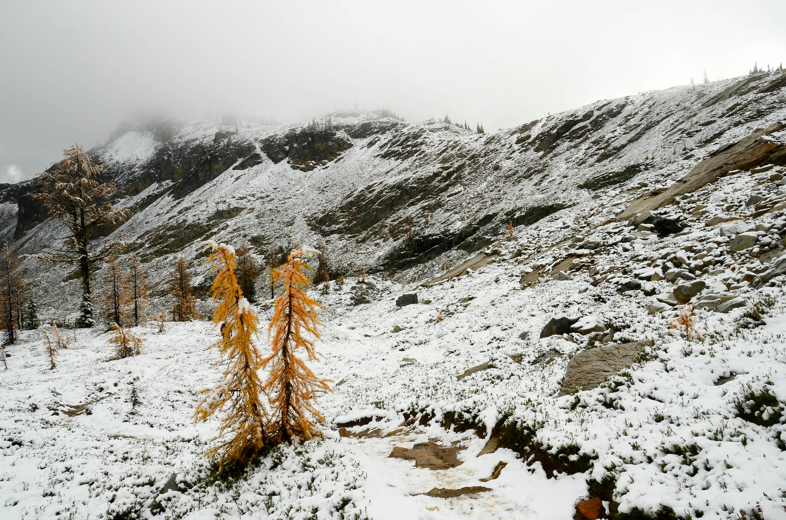 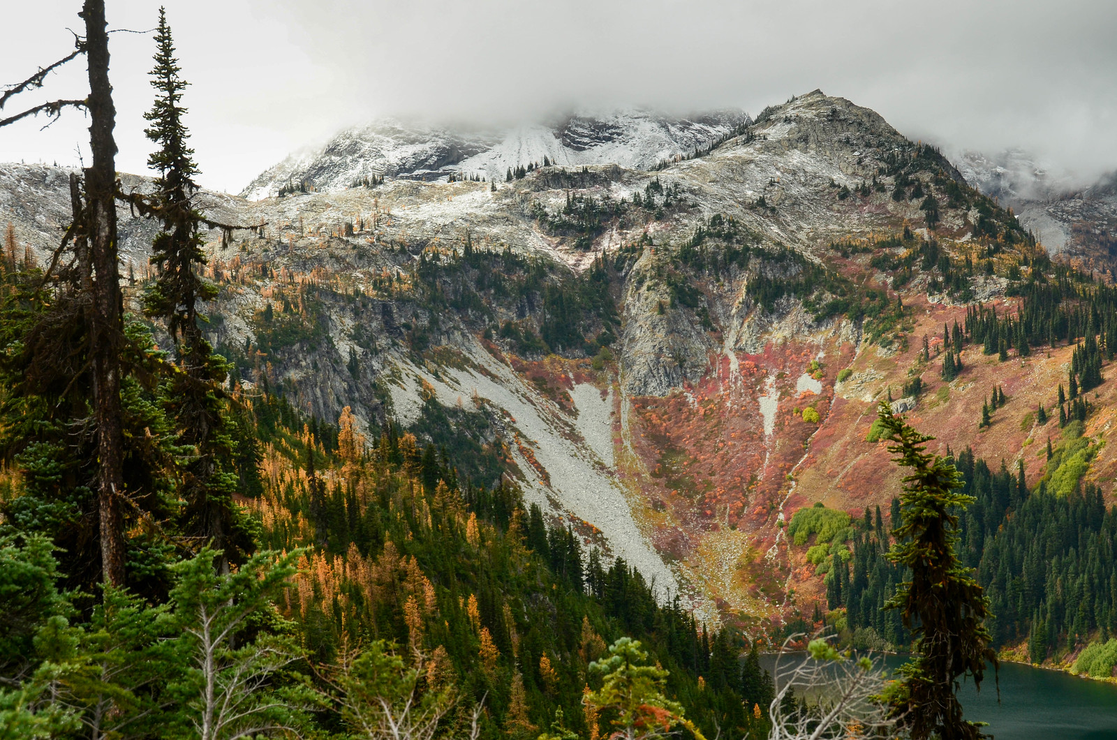 This is Maple Pass, which is probably the easiest hike in Washington relative to the quality and variety of scenery it delivers (a 7-mile loop that starts at a major highway). I strongly considered calling in sick last week and doing this hike while the sun was out, but the change in the weather actually made things more interesting by giving the larches a nice white background. Fall is my favorite time of the year to hike, assuming I can actually find a nice day to do it.
|
|
#
¿
Oct 14, 2014 02:32
|
|
|
Mr. Powers posted:What do you do for hiking if not summiting? Generally curious since I know out west it is a different beast. In Western Washington, it's common to hike to a dramatic mountain pass, an alpine lake or a ridge above the treeline. The Cascades are so rugged that you don't need to be at the top of a mountain to get spectacular views and reaching the summit often requires actual mountaineering skills. Of course, there are also plenty of (relatively) easy trails to current and former fire lookout sites. That's usually the best way to go if you want to stand on top of a summit in the Cascades.
|
|
#
¿
Oct 21, 2014 03:35
|
|
|
Good luck. Myakka River State Park has wilderness camping that is dog friendly (dogs only seem to be banned from cabins) but it's a bit more than three hours from Miami. Big Cypress is about the only dog-friendly place in South Florida that would even have that many miles of hiking trails.
|
|
#
¿
Dec 19, 2014 07:22
|
|
|
T. J. Eckleburg posted:So I just moved to Seattle and I want to go backpacking. Where should I go? For weekend loops, you have a lot of choices from FR 49 off the Mountain Loop Highway or FR 63 off HIghway 2. There are a lot of connecting trails in the Henry M Jackson/Glacier Peak Wilderness area so you can hike as much or as little as you'd like. If you're OK with a longer drive, the Pasayten Wilderness or the Teanaway area are good bets. If you're OK with a really long drive, go to Goat Rocks or the eastern side of Mt. St. Helens. Some of these areas require permits but they should be far easier to obtain than the Enchantments or the Wonderland trail.
|
|
#
¿
Aug 5, 2015 07:31
|
|
|
Electoral Surgery posted:I might be in Seattle in a few weeks and have time for a day hike. Can anyone recommend something? I'd be ok with a few thousand feet of elevation change and ~ 15 miles round trip, trailhead must be accessible by cheap small rental car. In late March it's likely that you will run into significant snow above 3,000 feet except on the westernmost foothills of the Cascades. Mt. Si is a reliable choice if you are looking for a big climb that probably won't have any snow until the very top. Rattlesnake Mountain is mostly known for the big rock outcropping on the east end (Rattlesnake Ledge) but the trail goes from one end of the ridge to the other so you can easily hike for 10-15 miles if you're so inclined. Tiger Mountain has a substantial network of trails that can easily be combined to create a long loop. That's your best bet if you don't want to do an out and back hike. Up north, Oyster Dome near Bellingham provides classic northwest views and can be combined with other hikes in the area. Expect mud. All of these hikes are accessible via paved roads.
|
|
#
¿
Feb 27, 2017 02:35
|
|
|
Electoral Surgery posted:Seattle goons, recommend me a hike. I'm going to hike Half Dome with some friends at the end of August: 16 miles, 4800 feet of elevation gain, and too much time in the sun. My girlfriend and I did Si and Mailbox this weekend without too much trouble, what day hikes would you recommend to build up to the Half Dome stats? We climb regularly so I'm not worried about dealing with the chains section. The really tough stuff is off Highway 20, near Leavenworth or north of Lake Chelan. Crater Mountain has something like 5,000 feet of elevation gain in 14 miles. Stiletto Peak and Sahale Arm both gain about 4000 feet in 12-14 miles. Sourdough Mountain is sort of a bigger version of Mt Si with a much more impressive view from the top. You could also try Mt. David, Snow Lakes or most of the hikes in the Sawtooth Range. If that sounds like too much driving, you could try stringing together multiple trails near Stevens Pass or east of the Mountain Loop Highway.
|
|
#
¿
Jul 5, 2017 07:35
|
|
|
Hey Canadians, I had the brilliant idea to join MEC over the weekend. Is there anything I can buy there that's notably cheaper or better than its REI equivalent?
|
|
#
¿
Apr 16, 2019 05:55
|
|
|
The great thing about the Olympic Peninsula is that the trails tend to connect in useful ways. You can easily turn two day hikes into an overnight or long weekend backpacking trip. Some ideas: Marmot Pass from the Sequim side and then back via the Dungeness River trail and a short road walk.  Deer Park to Grand Valley and then back via Cameron Creek or even Gray Wolf River if you're really trying to rack up the miles. Hiking above treeline in the rainshadow is the best.  Big o' Elwha Loop via Dodger Point (unless you really hate seeing other people on the trail, this will probably be more fun after the road gets fixed).  If you are at all interested in a wilderness beach hike, you owe it to yourself to do at least one of the big three (admittedly, I've only day hiked on the coast). Get a tide table and either arrange a shuttle or go with a buddy so you can leave a car at both ends. There will be a lot of people at the first beach you come across but it will be pretty quiet after that.
|
|
#
¿
Apr 19, 2020 22:20
|
|
|
xzzy posted:Dumb idiot question: I've lived in the snowy north over my whole life, and never once used snowshoes. Growing up I never really saw them either, except the vintage tennis racket style ones that are always hanging on a wall in a backwoods bar. But I guess they're popular now? This weekend a pretty good blanket covered the midwest (10 inches or so) and when I went out into the winter wonderland there were snowshoe folks everywhere. Snowshoes are useful in deep, un-compacted snow. They're mostly pointless if the snow is packed down and not particularly deep. I never owned or felt like I needed snowshoes when I lived in Anchorage, where a good year is 120 inches of dry snow, but they're pretty handy in the mountains of the Pacific Northwest where the passes regularly see 500+ inches of snow in a single season. Anyway, I think a lot of the people you see on snowshoes just heard that snowshoeing is a good way to burn a lot of calories and decided to try it out. In a foot of snow it's mostly just slower hiking. You don't really start working up an appetite unless you're blazing your own trail or trudging through deep powder.
|
|
#
¿
Feb 1, 2021 03:01
|
|
|
Bloody posted:Are there any overnight hikes within a few hours of Seattle that aren't guaranteed to be snowy and cold in early November? You probably won't run into snow below 3,000 feet in November unless there's a major storm (rain and washed-out forest roads are more likely). In the Cascades that at least leaves some good options for out-and back trips. Suiattle River and Thunder Creek both stay fairly low for quite a while. Most lower-elevation lakes aren't far enough from the road to feel like a major accomplishment but Goat Lake and Pete Lake would both work if you're mostly just interested in camping.
|
|
#
¿
Oct 11, 2021 06:52
|
|
|
Arkhamina posted:Ugh, sorry, yes, Olympic not Olympia. So close! I have opinions about visiting the Olympic Peninsula. Unlike Mt. Rainier, a lot of the highlights are at relatively low elevations. You won't be able to visit Seven Lakes Basin or Grand Valley but there is a lot to see and do in late spring. River hikes: it's possible to hike a long way up the Quilcene, Dungeness or Gray Wolf Rivers and May is when the rhododendrons bloom. Check wta.org for conditions. Some of these trails have obvious turnaround spots but for the most part you can just hike until you feel like stopping. Dungeness Spit: This is absolutely worth visiting if you like marine life and historic lighthouses. On a clear day it also comes with spectacular views of the mountains to the south and Canada to the north. Sequim: It's pronounced "skwim". Hurricane Ridge: If the weather cooperates (there's a webcam), the views are worthwhile even if there'll be too much snow on the ground to do any hiking in the area. Don't bother with Deer Park unless you see trip reports indicating that the snow has melted out because otherwise it's just a very long, boring drive to nowhere in particular. Lake Crescent: Instagram's favorite hike is Mt. Storm King. You gain about 2,000 feet in two miles in exchange for a pretty good selfie. On the north side of the lake there's a rail trail that mostly follows the shoreline. Start from the east end and go at least as far as Devil's Punchbowl. Renting a kayak and paddling around is also an option. Hoh Rainforest: Not optional even if you just do the nature trail. This is another place where you can walk along the river until you feel like turning around Pacific Coast: If you want to spend a day or two walking along a wilderness beach, you've come to the right place. Shi Shi Beach is currently closed to visitors and I'm not sure you can currently drive to Ozette but the entry points further south should be accessible. You'll need a tide table. For a short walk I think Ruby Beach and Second Beach are probably your best bets. Craig Romano's Day Hiking Olympic Peninsula is a very thorough guide to the region.
|
|
#
¿
Mar 2, 2022 07:42
|
|
|
|
| # ¿ May 4, 2024 06:38 |
|
|
Most of the campgrounds in North Cascades and Rainier close soon after the reservation period ends. Good weather may keep them open longer with limited services but obviously it's hard to know that in advance. That and road closures are the real issue with visiting those parks in late September. It's less of a concern at Olympic because the campgrounds are at lower elevations and are generally open year-round. A good alternative option is to camp in a national forest just outside the park boundary. The national forest campgrounds are open until they get snowed in and are rarely full outside of holiday weekends.
|
|
#
¿
Jul 19, 2023 20:21
|
|