


|
GreenCard78 posted:Maryland was chartered as a colony for Catholics. To elaborate it was founded by Catholic proprietors and at first was pretty tolerant for its time, even if Catholics were generally preferred for positions of power. Then Puritans became the majority and overthrew the government, establishing a new one which outlawed Catholicism.
|
 #
?
Feb 10, 2013 04:18
#
?
Feb 10, 2013 04:18
|
|


|

|
| # ? May 5, 2024 06:29 |
|
|
Crameltonian posted:To elaborate it was founded by Catholic proprietors and at first was pretty tolerant for its time, even if Catholics were generally preferred for positions of power. Then Puritans became the majority and overthrew the government, establishing a new one which outlawed Catholicism. And that's why we have the 1st Amendment! Pennsylvania and Rhode Island, I think, probably the 'best' colonies.
|
|
#
?
Feb 10, 2013 04:46
|
|

|
Crameltonian posted:To elaborate it was founded by Catholic proprietors and at first was pretty tolerant for its time, even if Catholics were generally preferred for positions of power. Then Puritans became the majority and overthrew the government, establishing a new one which outlawed Catholicism. Lord Baltimore was a huge proponent of the "refuge for English Catholics" idea, hence the city of Baltimore. the JJ posted:And that's why we have the 1st Amendment! The last slave wasn't free in Pennsylvania until 1847, thanks to the way they decided to do abolition. Your children would be free, but you'd remain a slave for life.
|
|
#
?
Feb 10, 2013 04:58
|
|

|
Farecoal posted:The last slave wasn't free in Pennsylvania until 1847, thanks to the way they decided to do abolition. Your children would be free, but you'd remain a slave for life. This suggests that the last slave died rather than gained freedom. also: Wikipedia tells me that their children were indentured servants until 28.
|
|
#
?
Feb 10, 2013 11:37
|
|

|
SPEAKING OF Colonial America and Maps (to get back on topic): The Middle Colonies, with convenient color-coding to show where settlements weren't allowed (aka: where Injuns and Frogs were likely). Never seen one actually separate these areas out from the colonies so clearly.
|
|
#
?
Feb 10, 2013 16:55
|
|

|
So I have a 1938 World Atlas lying around. Any maps you want me to scan out of it? Or possibly descriptions of countries? (Like Hedjaz and Najd being two different sovereign nations involved in a federation named "Saudi Arabia")
|
|
#
?
Feb 10, 2013 18:29
|
|

|
Patter Song posted:So I have a 1938 World Atlas lying around. Any maps you want me to scan out of it? Or possibly descriptions of countries? (Like Hedjaz and Najd being two different sovereign nations involved in a federation named "Saudi Arabia") It'd be cool to see China according to contemporaries around then.
|
|
#
?
Feb 10, 2013 18:44
|
|


|
Patter Song posted:So I have a 1938 World Atlas lying around. Any maps you want me to scan out of it? Or possibly descriptions of countries? (Like Hedjaz and Najd being two different sovereign nations involved in a federation named "Saudi Arabia") I have a 1947 wall map of the world that has some interesting stuff like that. Germany's occupies zones, all the USSR claims in tact, African colonies, Trans-Jordan/Palestine/"Proposed Jewish State", dotted line boundaries in western Poland, that sort of stuff. It's in really delicate condition since it was on my grandad's wall in his workshop for 6 years. It doesn't have any of that in Saudi Arabia, though. I'd like to see it.
|
|
#
?
Feb 10, 2013 19:01
|
|
|
Andy Impey posted:Not political, more social. Certainly interesting if you want to know how far certain cities influence spreads: The United States, divided by the most popular NFL team in each area (according to Facebook likes) My dad is one of those inexplicable Packers fans in Haywood County, North Carolina.
|
|
#
?
Feb 10, 2013 19:20
|
|


|
say no to scurvy posted:This suggests that the last slave died rather than gained freedom. Yeah,I used the wrong word. Apparently that system became the model for other northern colonies/states.
|
|
#
?
Feb 10, 2013 21:33
|
|
|
A Winner is Jew posted:I would post the a picture of the map, but it's interactive and really cool so here is a link to it instead. Highlight in the entry for Milledgeville, it says: "In the state capital, in a mock legislative session, drunken Union troops voted that Georgia would rejoin the Union." I have a feeling that this event was probably hilarious.
|
|
#
?
Feb 11, 2013 00:16
|
|


|
Mister Adequate posted:It'd be cool to see China according to contemporaries around then. I'll have access to a scanner tomorrow. I'll also say that this atlas has things like "Ethiopia: See Italian Empire of East Africa."
|
|
#
?
Feb 11, 2013 04:11
|
|
|
the JJ posted:And that's why we have the 1st Amendment!
|
|
#
?
Feb 11, 2013 04:44
|
|

|
An ethnic map of Chicago and suburbs. See if you can spot Cook County Jail. Link to Huge 
|
|
#
?
Feb 11, 2013 04:46
|
|

|
Probably that dense rectangle of blue in the orange heartland by the great gray band, I guess? 
|
|
#
?
Feb 11, 2013 07:07
|
|
|
gradenko_2000 posted:The Mercator Projection's Eurocentrism and Americentrism Mercator are primary navigational (shipping) plots precisely because a Rhumb Line represents a degree of travel (course heading).
|
|
#
?
Feb 11, 2013 10:18
|
|


|
esquilax posted:An ethnic map of Chicago and suburbs. See if you can spot Cook County Jail. These maps really freak me out because of how obviously "ghetto-ised" American cities are.
|
|
#
?
Feb 11, 2013 12:02
|
|


|
a pipe smoking dog posted:These maps really freak me out because of how obviously "ghetto-ised" American cities are. In Detroit you can see exactly where 8 Mile is. 
|
|
#
?
Feb 11, 2013 12:10
|
|


|
These maps always make me so proud of my home city.
|
|
#
?
Feb 11, 2013 14:19
|
|
|
Amarkov posted:These maps always make me so proud of my home city. Too bad about the boring though.
|
|
#
?
Feb 11, 2013 16:12
|
|


|
a pipe smoking dog posted:These maps really freak me out because of how obviously "ghetto-ised" American cities are. Do similar ones exist for European cities? You may be surprised at how they are.
|
|
#
?
Feb 11, 2013 16:14
|
|

|
esquilax posted:An ethnic map of Chicago and suburbs. See if you can spot Cook County Jail. That little cluster of whiteness on the Lake on the far right side is Whiting, I think, if I'm reading the map right. Growing up in the area, my parents always told me that Whiting "kept their property values high." I realize now that that was a dogwhistle for "prevented the poor, black people from East Chicago and Gary from moving in."
|
|
#
?
Feb 11, 2013 16:15
|
|

|
computer parts posted:Do similar ones exist for European cities? You may be surprised at how they are. http://www-e.uni-magdeburg.de/evans/docs/Londons_ethnic_groups.htm The maps don't exactly show "ghettos", but they do reveal how utterly horrible Outer London is.
|
|
#
?
Feb 11, 2013 16:23
|
|

|
Ras Het posted:http://www-e.uni-magdeburg.de/evans/docs/Londons_ethnic_groups.htm Yeah, I wouldn't be surprised if a number of French cities mapped out in the same way with the banlieues.
|
|
#
?
Feb 11, 2013 16:28
|
|

|
Since these maps seem pretty popular, why not link to the whole set? Plus an interactive NY Times version of the map: http://projects.nytimes.com/census/2010/explorer http://www.flickr.com/photos/walkingsf/sets/72157626354149574/detail/ e: my hometown 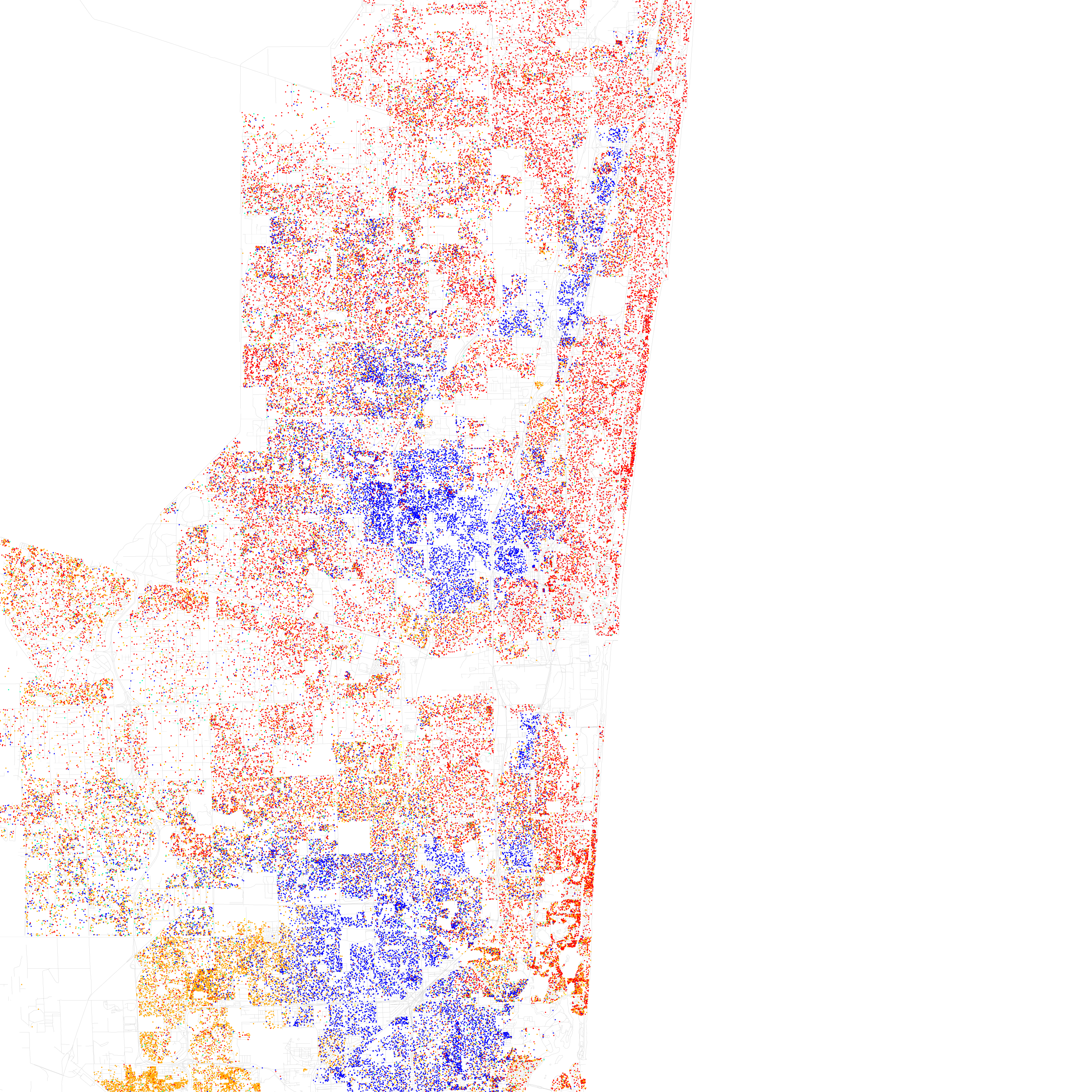 Click for huge poopy pee pee fucked around with this message at 16:40 on Feb 11, 2013 |
|
#
?
Feb 11, 2013 16:32
|
|

|
Dreylad posted:Yeah, I wouldn't be surprised if a number of French cities mapped out in the same way with the banlieues. That's the reverse situation...
|
|
#
?
Feb 11, 2013 17:05
|
|
|
Here's a small selection of sort of kind of ethnic maps for Berlin: Turkish nationals  Polish nationals  Nationals of Arab states, including Palestine  Combined total of a) foreign nationals, b) Germans born abroad, c) Germans under 18 years of age born in Germany with at least one parent who was born abroad  Skin color/race isn't recorded, though, so this is probably as close as you're going to get to those dot maps for American cities.
|
|
#
?
Feb 11, 2013 17:40
|
|

|
Hello Towel posted:That little cluster of whiteness on the Lake on the far right side is Whiting, I think, if I'm reading the map right. Growing up in the area, my parents always told me that Whiting "kept their property values high." I realize now that that was a dogwhistle for "prevented the poor, black people from East Chicago and Gary from moving in." I think that's Hegewisch, isn't it? I lived there as a baby back in the 80's. From what I remember, the Calumet River kind of sectioned it off from the rest of the South Side and Wolf Lake from Indiana. It's still got a lot of Polish and Italian I think. E: No that's Hyde Park. Hegewisch is the now-Latino area south of the Lake. EE: But it used to stay white out later, if you catch my drift. The 2000 version: 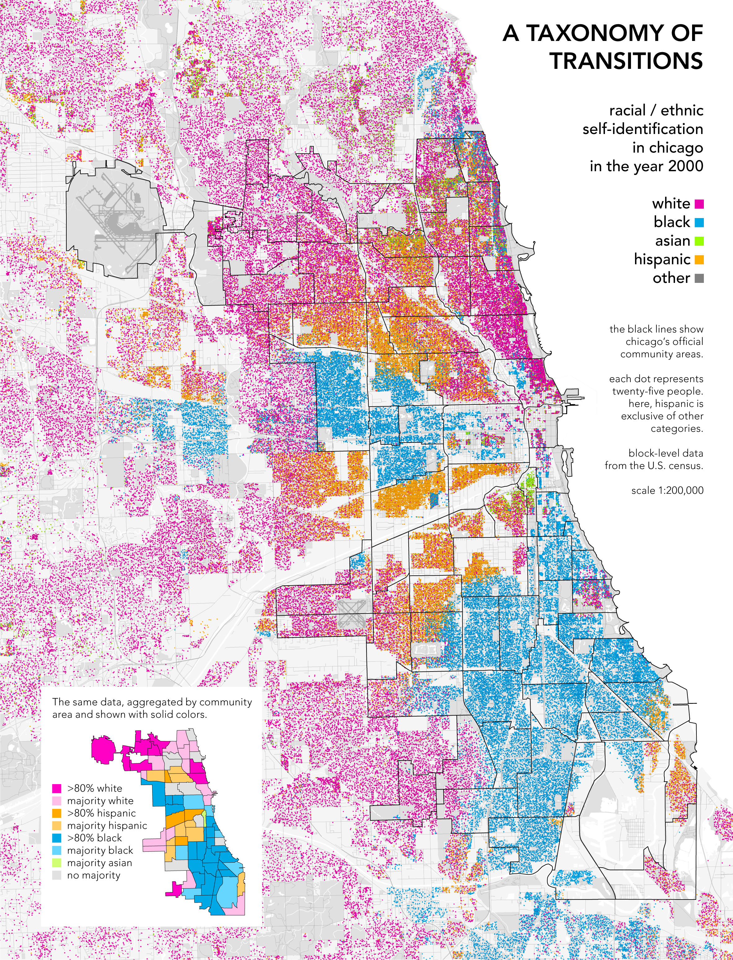
menino fucked around with this message at 19:40 on Feb 11, 2013 |
|
#
?
Feb 11, 2013 19:38
|
|

|
When you post these Ethnographic maps, could you also put down what city it is? I can recognize Amarkov's as San Jose, but I have no idea where Senor Gato's is.
|
|
#
?
Feb 11, 2013 19:53
|
|

|
You're right that Hegewisch had a lot of white people until recently, but I'm talking about the bit I circled in red here. It's down on the very edge. E: And looking at the newer map vs. the older one, you can see that there are already a number of Latino people moving into that area. 
|
|
#
?
Feb 11, 2013 19:56
|
|
|
Did any European cities (or countries) have the same sort of housing discrimination/white flight cycle that caused the hyper-seggregation of the big northern cities in the US?
|
|
#
?
Feb 11, 2013 20:08
|
|
|
Hello Towel posted:You're right that Hegewisch had a lot of white people until recently, but I'm talking about the bit I circled in red here. It's down on the very edge. I see. That's weird. I didn't know Whiting existed. My family is from South Holland/Hammond/Highland and I always assumed it was all Hammond next to Chicago. Whiting seems to be just that one cluster of houses between Indianapolis Blvd and the lake?
|
|
#
?
Feb 11, 2013 20:10
|
|
|
Dusseldorf posted:Did any European cities (or countries) have the same sort of housing discrimination/white flight cycle that caused the hyper-seggregation of the big northern cities in the US? So far as the UK is concerned, yes, roughly speaking - just look at that map of the ethnic concentrations in London. I don't think the discriminatory practices were as blatant, at any rate after anti-discrimination legislation came in, in the 70s, but white people moving out of inner city areas once they start being heavily populated by whatever ethnic minority is every bit as common. My mother grew up in part of Bradford that would have been pretty much totally white at the time, and fairly middle class. It's now mostly populated by people of Pakistani or Indian origin, and it's become a stereotypical inner city area with the usual problems.
|
|
#
?
Feb 11, 2013 20:28
|
|
|
menino posted:I see. That's weird. I didn't know Whiting existed. My family is from South Holland/Hammond/Highland and I always assumed it was all Hammond next to Chicago. Whiting seems to be just that one cluster of houses between Indianapolis Blvd and the lake? Indianapolis Blvd runs though Whiting. A little part of it extends all the way down to Cline. Hammond surrounds Whiting on two sides, with the lake and East Chicago on the other two. Glad to have someone to chat about NWI with, hah. For content: As a whole, Gary, IN is 85% African-American, largely due to white flight in the 1970s. This map shows race distribution in the area (darker blue = higher % African-American) The part on the far right, colored lighter, is called Miller, or Miller Beach. It was formerly an independent town, and was taken by the city of Gary in the 1918. It includes parts of the well-known Indiana Dunes. It's interesting (and extremely unfortunate) to me to see the racial polarization in the suburban area where I grew up, accompanying the demise of the steel industry. 
|
|
#
?
Feb 11, 2013 21:15
|
|
|
Ras Het posted:That's the reverse situation... Er yeah. I shouldn't post while on a lot of cold medication.
|
|
#
?
Feb 11, 2013 22:03
|
|
|
Milwaukee is supposedly the most segregated city in the US. I buy it. Another fun round of "Spot the Prison" here. Angiepants fucked around with this message at 22:13 on Feb 11, 2013 |
|
#
?
Feb 11, 2013 22:10
|
|
|
Dusseldorf posted:Did any European cities (or countries) have the same sort of housing discrimination/white flight cycle that caused the hyper-seggregation of the big northern cities in the US? To add to this, don't minorities in Europe tend to live in the suburbs as opposed to the inner city? I've never been to Europe, though. Fun fact, the places that are getting abandoned the most now are the first ring suburbs. It'll be interesting to see if that eventually spreads to further out suburbs because they won't be economically viable anymore to commute from anymore.
|
|
#
?
Feb 11, 2013 22:45
|
|

|
Angiepants posted:Milwaukee is supposedly the most segregated city in the US. I buy it. More like "Spot Marquette"
|
|
#
?
Feb 11, 2013 22:55
|
|
|
Boon posted:More like "Spot Marquette" Spot the Prison would be really fun if there was a statewide map.
|
|
#
?
Feb 11, 2013 23:08
|
|
|

|
| # ? May 5, 2024 06:29 |
|
|
Angiepants posted:Spot the Prison would be really fun if there was a statewide map. There is. That's a screen shot of the NYT's Mapping America. It's posted in this thread and interactive for all kinds of census data.
|
|
#
?
Feb 11, 2013 23:12
|
|