


|
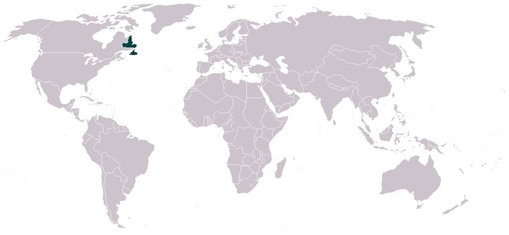
Budzilla posted:This should have been posted in the OP. PNAC redrawing of the ME. I'm kind of surprised to see Azerbaijan expanded. Also, giving northern Afghanistan the tribal areas of Pakistan "these areas are ungovernable from a distant and centralized government, have fun!"
|
 #
¿
Feb 5, 2013 16:45
#
¿
Feb 5, 2013 16:45
|
|


|

|
| # ¿ May 4, 2024 06:35 |
|
|
Reveilled posted:If I recall correctly, the premise of the map was "if we had the benefit of hindsight when redrawing the map of the middle east post-WWI and through the era of decolonisation, what would have been the best way to do it?" Maryland, DC and NoVA do not like their placement. I'm surprised there isn't a Megalopolis nation from Virginia Beach to Boston plus some country side so we can watch the leaves change colors.
|
|
#
¿
Feb 6, 2013 01:39
|
|

|
computer parts posted:Was Maryland the one that was all "Catholics and Jews can come here!" (I'm guessing so due to the name) Maryland was chartered as a colony for Catholics.
|
|
#
¿
Feb 9, 2013 22:54
|
|
|
Dusseldorf posted:Did any European cities (or countries) have the same sort of housing discrimination/white flight cycle that caused the hyper-seggregation of the big northern cities in the US? To add to this, don't minorities in Europe tend to live in the suburbs as opposed to the inner city? I've never been to Europe, though. Fun fact, the places that are getting abandoned the most now are the first ring suburbs. It'll be interesting to see if that eventually spreads to further out suburbs because they won't be economically viable anymore to commute from anymore.
|
|
#
¿
Feb 11, 2013 22:45
|
|
|
Angiepants posted:Spot the Prison would be really fun if there was a statewide map. There is. That's a screen shot of the NYT's Mapping America. It's posted in this thread and interactive for all kinds of census data.
|
|
#
¿
Feb 11, 2013 23:12
|
|
|
Bodymore, Murdaland. A pretty accurate map in general, the funniest one is the "white people who wear clothes and drive cars from the 90s" or maybe North Avenue getting labeled as "nothing but trouble."
|
|
#
¿
Feb 11, 2013 23:23
|
|
|
Really? That's crazy. Here not only do they have to take a census every ten years but they have to count every person literally rather than using sampling data which could be more accurate.
|
|
#
¿
Feb 11, 2013 23:29
|
|
|
Are you a person or a blob?
|
|
#
¿
Feb 11, 2013 23:39
|
|
|
De Nomolos posted:
The funny thing about PG is it's the wealthiest black majority county or city in the country with nearly 900,000 people, slightly more than two thirds of which are black and an average household income of around $80,000. It's got one of the biggest divides of wealth in the region.
|
|
#
¿
Feb 14, 2013 00:25
|
|

|
McDowell posted:Cartography is an interesting protoscience. There are a decent amount of geographers who would argue that geography is an "original science" and that a wide array of other sciences are spin offs of geography. In a nut shell, people wanted to know where things were, like a good plain to hunt animals, forage food or plant some grains, and from there some people would pick up a specialization. The main group would need to know "where" about something else and go from there. Everything is tied in spatial relation. Cartography is more about making maps pretty and accurate. Where are all the necessary scale bars and north arrows in many of these maps? For shame.  Have a wet dream of a rail transportation system  
|
|
#
¿
Feb 14, 2013 04:43
|
|
|
LP97S posted:Well it time to post the map that ends the thread. I think Burma/Myanmar gets screwed the most heavily on this one.
|
|
#
¿
Feb 14, 2013 21:39
|
|

|
McDowell posted:Wind Patterns - nope not a complex and sensitive thermodynamic mechanism. Trains are gay socialism. Keep driving a truck LIKE A MAN. Do you have any idea how many people don't get wind patterns tend to be similar? And that there is a general wind pattern? A reason why things happen? A reason why the weather happens the way it does in your local area and you don't need to be a god drat meteorologist to understand why overall climate trends happen in your area because of the wind?  That would be better fitting if it was larger and was throwing up little ones of itself. Landsat 8  This is a picture of Landsat 8 that was launched around 1:30 PM EST on Monday. It is part of the Landsat Continuity Program. The Landsat program provides imagery of the earth and passes over ever spot on the planet about twice a month. It is continuously uploading information which then becomes free to the public. For $100, you could download IDRISI and analyze your own data taken from space! How cool is that? What makes it political loaded? Landsat 7, the previous Landsat, is a replacement of Landsat 5 which was launched in the mid 80s. Landsat 5 was getting old and like all projects, when one goes up the next is already being planned. Landsat 6 was sent up in 1993 but failed to achieve orbit. This meant that Landsat 7 was needed as quickly as possible and was sent up in 1999. In 2003, Landsat 7 started scan line failures, basically some of the image was hosed up. It looked like this:  This was repaired using previous data or data from Landsat 7 as it passed over the area from a slightly different point of view. It took 10 years for Congress to get its act together to give money out for the Landsat Program. Despite the fact that the information gathered by the Landsat program is incredibly valuable, there are no future plans for the next satellite.  The quick run down on how it works is that it takes images of the ground (duh) at many different bands of the electromagnetic spectrum. This is a remotely sensed image (map) produced from Landsat 7:  Remote sensing is awesome because it allows us to take images of the earth and prove environmental changes and do spatial analysis.
|
|
#
¿
Feb 15, 2013 03:20
|
|
|
Crameltonian posted:The Middle East and North Africa count as White? I want to see European countries introduce this classification, our racists would have the most amazing fits. Not sure how it works abroad but yes, North Africans, Arabs, people from the Middle East are all white according to the US Census. http://www.ohr.gatech.edu/race%20definitions That's from Georgia Tech but if you apply to jobs in the US, they'll have an optional demographic section at the end and they come with these same federal definitions for people to use.
|
|
#
¿
Feb 18, 2013 15:46
|
|
|
I think the argument is "it's not really Catholic because they adopted their previous religion into Catholicism and do it a little differently." 
|
|
#
¿
Feb 18, 2013 16:17
|
|
|
A Buttery Pastry posted:Maybe I just don't have much faith in the US, but I've seen so many Americans that basically see it as a fluke of history that Greenland isn't theirs that I have my doubts that Greenland would remain independent for long. 50,000 people (mostly indigenous) controlling a whole lot of natural resources that 300+ million Americans want, right in America's backyard? Not to mention them being ruled by actual socialists? It's pretty much the perfect storm of factors arguing for an eventual American takeover. Americans do not give a gently caress about Greenland except for an air base. Red_Mage posted:A less interactive more big map: Looking at DC, what's a general hate group? I understand black separatist in DC but not general hate. "We don't take too kindly to folks who don't take too kindly, round nah!"
|
|
#
¿
Feb 19, 2013 15:31
|
|

|
This response is the best response. There are plenty of folks in dc who fit this category but just don't wear the appropriate sign.
|
|
#
¿
Feb 19, 2013 16:19
|
|

|
The US doesn't give a gently caress about Greenland. The Chinese and Russians are not there. We have our air base. There is no oil. We send the US Navy where we drat well please already and I assure you, there are already plans for protecting shipping lanes through there should that became a viable passage. As it stands right now, I think a few ships go through there but only in the middle of the summer when there is reported ice breaks enough. Shipping lanes would also have to change so that somewhere in Alaska or Canada became a good shipping point to send whatever to Europe or at least out the other side. Even if there was oil, it's a lot less invasive if we just send our companies and have them work within the system already established than take over the country directly.twoday posted:The Dominion of Newfoundland was a British Dominion from 1907 to 1949 (before which the territory had the status of a British colony, self-governing from 1855). Now that is interesting. Meet Kaliningrad, Russia. It's not really in Russia but to the west and an exclave of Russia.  Russia gets a warm water port to not have to pass through Finnish or Estonian waters but it's still not attached to Russia proper. 
|
|
#
¿
Feb 20, 2013 02:39
|
|
|
That reminds me of the peace walls in Belfast    Vice did an interesting travel guide there https://www.youtube.com/watch?v=4nzDuiv3U8o GreenCard78 fucked around with this message at 04:04 on Feb 22, 2013 |
|
#
¿
Feb 22, 2013 04:01
|
|
|
You know Orlando Ferguson had a roulette table with the Earth like that on it. Money's on the Americas, fellas.Mu Cow posted:Rivers make really bad borders. When the European powers divided up Africa, some of the boundaries were rivers. The problem was people didn't view rivers as boundaries but as major transportation networks, the boundaries were elsewhere. You can imagine where the problems started.
|
|
#
¿
Feb 25, 2013 03:27
|
|
|
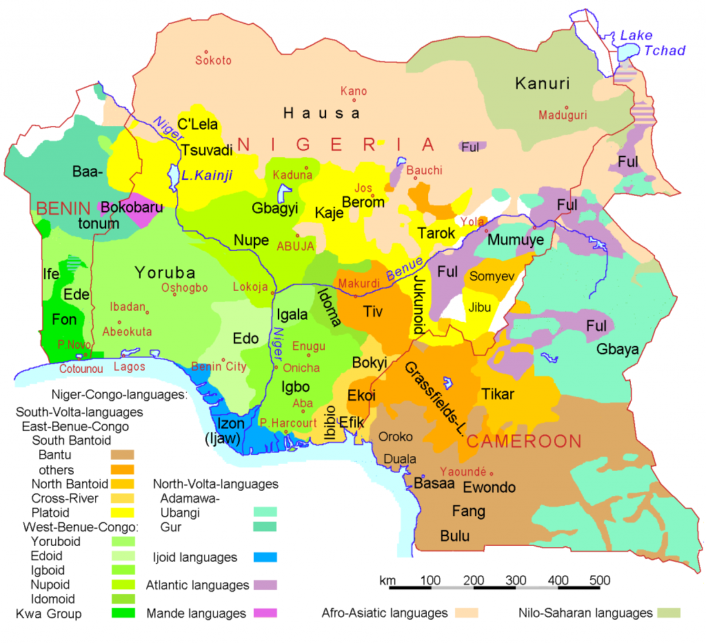
esquilax posted:How so? Most conflict in Africa is local and intra-state, and is between ethnic groups rather than between states. I have a really hard time believing that that Nigeria, for example, would have been worse off if it had been divided into Yoruba, Igbo, and Hausa states via the Niger instead of just throwing them all together. That's pretty much the point. Europeans didn't think about African ethnic and tribal considerations and drew things rather arbitrarily, thus dividing people by things they hadn't normally been divided by before (rivers) or grouping peoples together into a country who would not normally be grouped together.   The ethnolinguistic map isn't exactly the best ethnic map but it helps illustrate the idea. There is an estimated 2,000+ languages, not just dialects, in Africa. The languages are likely as diverse as the cultures and people. E: The map doesn't say 2,000 itself, that figure is from a class.
|
|
#
¿
Feb 25, 2013 06:55
|
|
|
esquilax posted:Well then the issue is not that rivers make bad borders, it was that there were simply not enough borders drawn to create a state for every nation. Rivers actually make very good borders, since they're an obvious geographical feature which helps to minimize border disputes between states (though can never really be eliminated). There will always be ethnic overlap in geographic areas, which will generally create competing claims on a given geographic area. Having clear geographic borders helps to avoid inter-state conflict. You're missing the point. It's a very grey thing. Some rivers make very good borders while some rivers make very bad borders. You shouldn't need to know 43.21% of rivers make 54.32% of borders bad to understand this. Rivers aren't the only form of border creation. It is an example of how what seems like a good border can turn out to be a bad border when local context is not thought about. The point was, European colonial powers made poor choices when dividing up Africa because odds are, it would not have divided itself up like that. Many of the ethnic and tribal conflicts in Africa today are the result of groups fighting for power in a nation state they might not have been in together had it not been for Europeans drawing their borders. It's interesting you bring up Eritrea and Ethiopia because Eritrea only separated from Ethiopia about twenty years ago and Ethiopia remained pretty much free during he scramble for Africa. Yes, the Italians tried but they failed. When talking about Europeans in Africa, Ethiopia is pretty unique. E: Mu cow's post about which rivers make good and bad borders is pretty much spot on. GreenCard78 fucked around with this message at 17:04 on Feb 25, 2013 |
|
#
¿
Feb 25, 2013 17:00
|
|
|
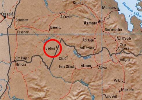
esquilax posted:If you think I missed your point then you missed mine. When confronted with the fact that the vast majority of violence is between ethnicities inside a state rather than between states, the conclusion should not be that the current lines are in the wrong spots, it should be that there are not enough lines. Compared to all the poo poo that has happened in Zaire/DRC in the past, any problems caused by having a border on the Kongo river are essentially a non issue. The only major conflict that I could find along the Kongo was entirely on the left bank, between two DRC tribes (in Dongo). When I get home, I'll try to look through an old book for river disputes. The point wasn't just rivers, it's bad borders in general with a focus on Europeans drawing them to their desire without consideration to the locals. Ethiopia and Eritrea are a special case in a continent full of uniqueness, their river border wasn't made directly by Europeans. IIRC, the Italians were in Eritrea more so than Ethiopia but I don't recall to what extent they exercised their power and if it would match up to current borders ie the river. Koramei posted:Or that the lines are in the wrong spots, since if there isn't inter-state violence then the ethnic groups in different states are friendlier than those in the same state, at least in theory. The problem with dividing Africa into even smaller chunks is that each of the nations will be even more under represented in the world stage. This is pretty much it. In the 1960s, The Organization of African Unity (now the African Union) decided to use the colonial lines. They admit they were hosed up but the alternative to opening border discussions was worse because it was basically a giant can of worms. That's one reason why you see conflict contained within nations in Africa today for the most part. There are obviously exceptions to this. Overall, DarkCrawler posted:Looking at that it seems to me that dividing things into states wouldn't have worked no matter what borders you made. Maybe within the next century Africans will experience nationalism or another ism in which tribal and ethnic conflicts stop or decrease because people now see each other as from whatever country instead of whatever smaller group. The idea of who fits what groups will change (see ethnic Hans) and we'll have a new context to operate in. This all falls into Regional Geography which is the context for which most people generally view place. This place vs that place vs the third place on whatever defining feature is being used. It's true that most people view regions as very real things but there are geographers and universities who do not recognize regional geography because it full of holes. If you want to read about that, I'd suggest starting with The Inadequacy of The Regional Concept to understand why regions are poorly defined and how a river may or may not be a good border, especially if someone else draws it for you.
|
|
#
¿
Feb 25, 2013 21:33
|
|
|
Don't forget to stump all your friends with the trivia knowledge that Haarlem is a Dutch name. If you want to read a good book and fairly quick read about the Dutch in (what is now) New York, Island at the Center of the World by Russell Sorto is pretty interesting.
|
|
#
¿
Mar 10, 2013 21:38
|
|
|
Russell William Thorpe posted:Is it me or is this map... horseshit? China was the most welcoming place I've ever been. I think the key may be that they asked people how welcoming they'd be. Chinese people like to get fired up with *talk* about how nationalistic they are. This breaks down completely at the individual level- like how there are still gun shows in Blue states and gay bars in Red states etc. Like whenever there's some anti-Japanese thing in the news, in China there are anti-Japanese protests and the sushi restaurants put up big Chinese flags... but are still open for business because guess what, Chinese people will still gladly enjoy Japanese food. Part of the problem is going to China can be a crapshoot. This map has obvious flaws because labeling such a huge geographical area with more than a billion people and all kinds of closed, not closed, for tourists, exposed to tourists, never seen a foreigner, etc places is not easy. They used an index which is probably inaccurate for much of the country. It also could be a people vs government divide or anything you could imagine.
|
|
#
¿
Mar 25, 2013 04:44
|
|
|
Are the French names in their English corruptions of French? At least France itself?
|
|
#
¿
Apr 1, 2013 16:44
|
|
|
That shows what I know about the French language. 
|
|
#
¿
Apr 1, 2013 16:57
|
|
|
From googling "how sees the world" "How God sees the world"   I remember this on the stands        Have a link   
|
|
#
¿
Apr 1, 2013 23:22
|
|
|
cheerfullydrab posted:I thought Mauretania was pretty safe. You mean the country that still has 10-20% of its population enslaved? Angiepants posted:What's so special about Botswana? I'm not sure, either but everything I've heard about traveling to Botswana is that it's been very safe and a great place to travel.
|
|
#
¿
Apr 3, 2013 23:31
|
|
|
They made slavery illegal in like 1905? and didn't work, made it illegal again in 1980 but that didn't stop anyone because it was 2007 when they made owning slaves illegal and punishable. I think they've only prosecuted one person or so. http://en.wikipedia.org/wiki/Mauritania http://en.wikipedia.org/wiki/Slavery_in_Mauritania http://www.saiia.org.za/governance-and-aprm-opinion/mauritania-made-slavery-illegal-last-month.html http://www.bbc.co.uk/worldservice/specials/1458_abolition/page4.shtml http://www.cnn.com/interactive/2012/03/world/mauritania.slaverys.last.stronghold/index.html http://www.theafricareport.com/Columns/mauritania-a-love-affair-with-slavery.html You can google more if you like but that's really just the tip of the iceberg. You know there are still many places with people in bondage today, April 3 the year of our lord 2013?
|
|
#
¿
Apr 3, 2013 23:43
|
|
|
Koramei posted:I guess there's something more disturbing to me about the idea of it being open and legal rather than under a (thin) veil, although you're right that that's silly. It's been a few years since I have read much about it, in fact I remember the thread on it back in 07, but it's not even a thin veil. The reason they outlawed it was because of international pressure and in order to get whatever it was they wanted, they needed to adopt it. There was a story about a woman who was around 40 years old but couldn't tell how old she was or even really understand measurements of time because she had never been taught. Her place as a slave was just the way things were and so was everything she had ever done. I think she might have been freed and that's why she was interviewed but she didn't get the concept of being freed. Definitely one of the most  articles I've read on here. articles I've read on here.Here's an interview with a different person born into slavery
|
|
#
¿
Apr 3, 2013 23:57
|
|
|
As it's been said before, Mauritania seems fairly lawless what with slavery still going on that if someone decided to kidnap you, no one is there to prevent it, help you or even care. Off to the desert you go.
|
|
#
¿
Apr 4, 2013 21:17
|
|
|
I'd like to but am not quite there yet, finishing up school.
|
|
#
¿
Apr 11, 2013 18:06
|
|
|
Kegluneq posted:I've learned enough about GIS through archaeology to know that if you have to ask, you are never going to understand the answer. It is a pretty awesome tool but it's definitely not particularly user friendly. What about GIS is not user friendly? Not saying that it is, just curious.
|
|
#
¿
Apr 14, 2013 21:56
|
|
|
Rodya Raskolnikov posted:Went to college for Geography, professional career has been as a technician and analyst. Geoprocessing tools, you are my bitch.
|
|
#
¿
Apr 16, 2013 04:41
|
|

|
Rodya Raskolnikov posted:My capstone was 2 years ago and I hope that if I had to make a cartographic product at work it would turn out a lot better. I hate how maps made in ArcMap always look very uniform. Has anyone used any other mapping software oriented towards more manual map creation? It's really easy to dump census data into ArcMap but the labeling engine is terrible about dropping labels if there's the tiniest conflict between two labeled layers. I didn't get the opportunity to fit it into my schedule, but my university has Cartography I and Cartography II that is all about using Illustrator to make the maps look much better. I was talking with someone who showed me their projects and they'll make the map product in Arc but leave it rather basic then make it look fantastic in Illustrator. Even with maps with "worse" data come out looking better because of the magic they can work. Using IDRISI now makes me really wish I knew Illustrator. It can process data very well but fuuuuuck, it looks awful. 
|
|
#
¿
Apr 17, 2013 15:56
|
|
|
I'd be curious to know about the rural/urban divide of internet connectivity in Latin America, especially Mexico. The richest man in the world got his wealth from telecommunications in Latin America, there's got to be good access in some places. That being said, there are likely a ton of people who still cannot afford it even if it is there.
|
|
#
¿
Apr 18, 2013 17:05
|
|
|
ChipNDip posted:A much better map: While that map might be better because it has more information, it would piss of a cartographer because it's so all over the place. 
|
|
#
¿
Apr 22, 2013 22:24
|
|

|
Shbobdb posted:Thanks. Yeah, I've got a lot of the actual history down. But that is why I think it would be super cool to see it in map form, you know? We should see if we can get a big ol' history of food and drink megathread going. That would be sweet. If you've got the history, turn it into data (excel) and it shouldn't be too hard for someone to make a map in Arc.
|
|
#
¿
Apr 23, 2013 01:10
|
|
|
Shbobdb posted:Sorry, I misspoke. I've got the overall trends of the history down. Not actual data. I was overly casual in a written medium, my bad. That's basically coloring, the official word escapes me right now, of a map and then pressing a button so that polygons capture the coordinate system you are using and then have a place in space. Hit me up after May 22 with the data and I'll see what I can do for you.
|
|
#
¿
Apr 23, 2013 03:06
|
|
|

|
| # ¿ May 4, 2024 06:35 |
|
|
Jerry Cotton posted:When you think about it for a while I'm sure you'll come up with a lot more than just that, not necessarily the same in all countries (animal porn is legal in some countries I think). My point was that it would be kind of nice to know what kinds of restrictions the maker of the map meant with the yellow countries because I'm assuming they meant a specific kind of restriction (distribution? content? something else?). There was a story about someone seeing a "donkey show" in Tijuana. I don't know if it was true or not but  Does anyone have a map about animal fighting? Bull fights, chickens, dogs, do any other cultures fight anything else? Do scorpions and spiders count?
|
|
#
¿
Apr 23, 2013 18:18
|
|