

|
Hello map thread, do you also accept unofficial maps? Because I have a lovely homemade map that I'd like to hear your opinion about :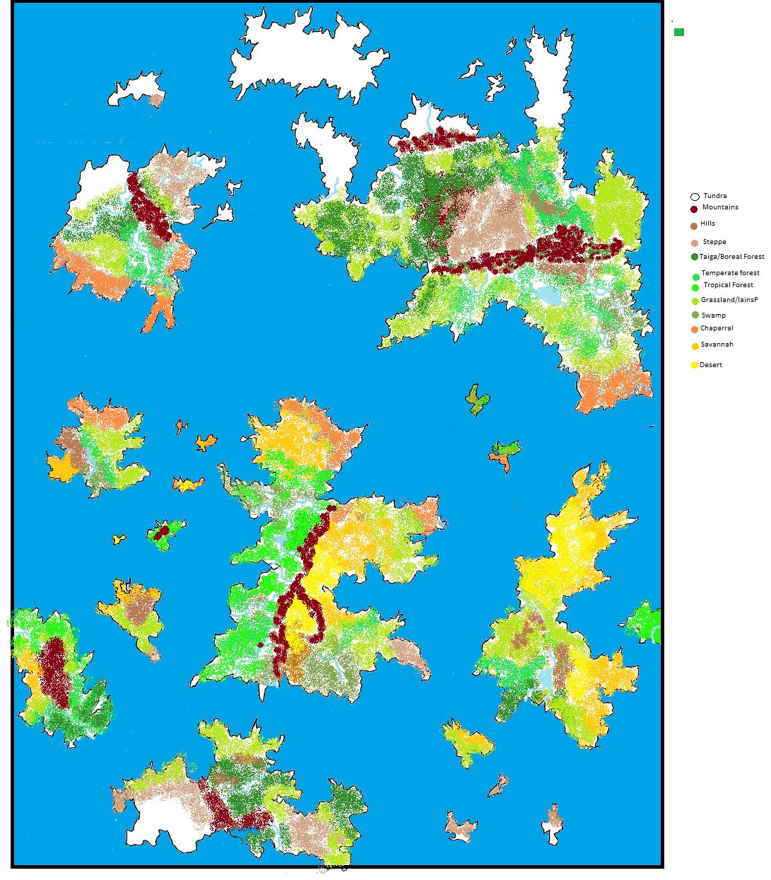 Now, I was told in the chat thread that the position of the mountains doesn't really work, because they are supposed to follow along the shape of the continent and not cut it in half. Effectronica was nice enough to make me an enlarged version with optimal mountain position, but I would like to get some more opinions before placing all those biomes again. 
|
 #
¿
Jun 1, 2015 19:35
#
¿
Jun 1, 2015 19:35
|
|


|

|
| # ¿ May 17, 2024 13:46 |
|
|
thank you. Weirdo posted:As a geology grad, thumbs up for Effectronica's advice. To add my two cents, the layout makes me think there must be a deep volcanic trench between the northern and southern continents, so maybe the continents are slowly moving north and south (like a few centimeters a year). Also you could put some volcanic mountains on those islands if you wanted, sort of like Japan or Hawaii. Are you referring to the islands west of the central continent? Because I love the idea of them Being volcanic. As for the volcanic trench, I have a question: what exactly does that mean for the stretch of sea between those regions? Underwater volcanic activity? That might be a good place to have an underwater civilization, since it given them access to Bucnasti posted:I'm pretty sure that's exactly what this thread is for. I did try to do that with my rivers on my first try, but I allowed myself a bit of liberty because I noticed that Earth rivers do seem to meander a bit. I guess that accounts for different heights on the plain and small hills. I also think that not all of my civilizations will be pre-industrial, but this is something that can wait until I have the physical map of the world down. I will check that site tomorrow, as I am on mobile now and can't properly See how it is.
|
|
#
¿
Jun 1, 2015 21:50
|
|
|
That was supposed to be' "gives them access to smelting". Sorry about that.
|
|
#
¿
Jun 1, 2015 23:18
|
|
|
Lemniscate Blue posted:When you put biomes on that map, remember to note where your prevailing winds are in that latitude. Generally you'll have equatorial forests, then a band of desert on either side, and rain shadows will create wet areas on the windward side of mountains (rivers will form here) and dry areas on the leeward side. In the first version of this map, I had actually a separate map for water currents and winds, exactly to keep track of these sort of things. I am now remaking it using Paint.net As nice as Campaing Cartographer looks, I don't like the idea of dropping 50$ for something with such a niche utility, especially if I can obtain a decent result using a free program. e: Which leads me to another question: what happens when two water currents move one against the other, when they clash? Whirlpools? Bad weather zone? It just doesn't happen in nature? paradoxGentleman fucked around with this message at 23:21 on Jun 3, 2015 |
|
#
¿
Jun 3, 2015 23:06
|
|
|
I made some progress on the map and would like to hear your opinions: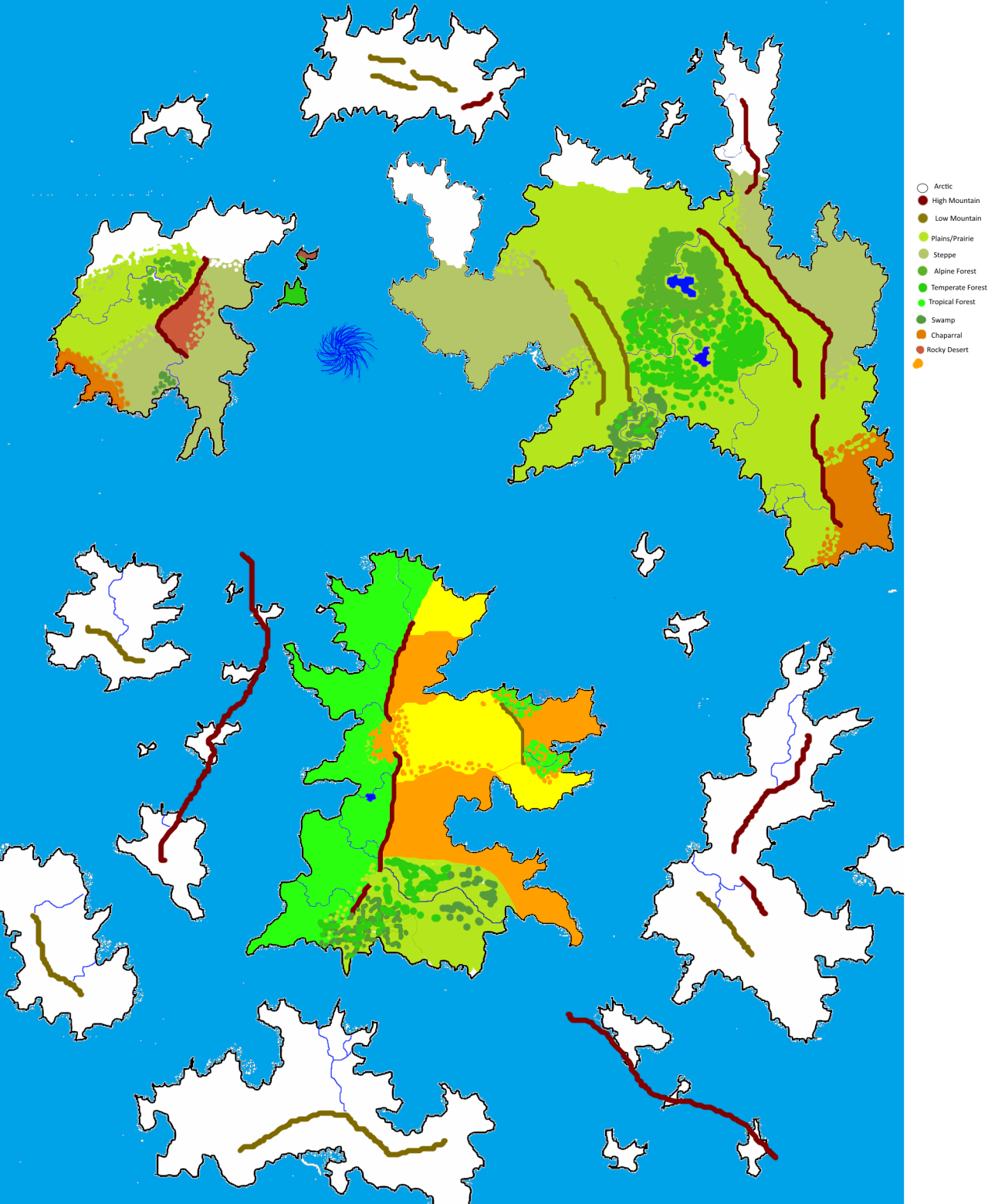 The whirlpool between the two northern continents is caused by a giant slug/mussel hybrid that lives at the bottom of the ocean and slowly crawls around devouring fish in its wake. Sorry Zorai, I saw "giant ocean whirlpool" and "mythology" together and my imagination went wild. Its WIP name is Salt's Maw. That being said I still have a couple of questions: -Does the rocky desert I placed on the north-western continent make sense? I figured that since it was not only on the rain shadow, but that whatever winds could have brought rain to that zone would have been absobed by the whirlpool, which means no erosion, which could allow such a biome to exist, but I am not sure. -What about the swamps? I have a fondness for swamps, and I feel I might have gone overboard with them. I don't honestly know where to place them if not near rivers. That's what comes to mind, but if I messed up anything else please let me know. e: I just realized I forgot to complete the legend. The orange you see in the central continent is supposed to be savannah, and the yellow desert.
|
|
#
¿
Jun 14, 2015 14:34
|
|
|

|
| # ¿ May 17, 2024 13:46 |
|
|
Terribly sorry, I messed up something else on the map and figured I should just patch it up:Angrymog posted:Probably off-base here, but reverse your desert and savannah patches, so that the deserts are by the mountains, and the savannahs at the gaps? The idea is that since that zone is sandwiched between two mountain ranges, it's hard for the rain-bringing winds to reach it, so it's extremely dry there.
|
|
#
¿
Jun 14, 2015 14:59
|
|