

|
hi folks. this thread is about southern california hikes. we have some very nice + scenic areas despite being a dystopian metropolis. i am a brand new baby hiker as of LAST MONTH so I have not seen much of it yet. i have been on two trails, both at Chantry Flats. 1 was Sturtevant Falls, which was a bit disappointing cause it was so crowded, except when we went up on what I think is called the lower trail to the top of the falls and took a loop around to the gabrielino trail. there were only a couple other people(a Saturday morning last month) and there were some really good visuals. also, we met this guy: http://www.canyoncartography.com/ who was repairing one of the telephone wires. he was very nice and informative and showed us his map. the other trail I went on was to hermit falls which was pretty relaxing, very short though and not much water in the falls. my friends are experienced hikers who have been all over. they want to take me up to mount baldy(mount san antonio) which I am excited for. here is my next destination tho: 
|
 #
?
Dec 20, 2015 22:39
#
?
Dec 20, 2015 22:39
|
|


|

|
| # ? May 1, 2024 17:56 |
|
|
I consider walking up hills in Griffith Park to be hiking, and I do it for a few hours every other week because I am an idiot. But, I do have fun doing it with friends, as always along with some gentle ribbing as to whose shirt is dampest from sweat, for example
|
|
#
?
Dec 25, 2015 04:09
|
|

|
switzer falls is p good
|
|
#
?
Dec 25, 2015 08:27
|
|

|
Anyone know of good birding trails near Malibu? My grandma got a new camera for christmas and I offered to take her birdwatching so I could teach her how to use it. She's 86 or so but in good shape for her age; she can probably go 2-3 miles in either direction, as long as we're on a trail that doesn't have too many steep grades. if you help me out ill post birdpics
|
|
#
?
Dec 26, 2015 08:07
|
|


|
Now is the time to desert hike. Go hike the abandoned trestle bridge east of San Diego. It's wild west as gently caress.
|
|
#
?
Dec 29, 2015 23:00
|
|

|
I'm going to california for 2 weeks on monday and I'm looking forward to walking some trails. Even going to yosmite for a day (I know it's cold, doesn't bother me much)
|
|
#
?
Dec 30, 2015 17:57
|
|

|
In the San Gabriels: Bridge to Nowhere is awesome, but best in the summer when you can swim. Also crazy busy if you go on a bungee jumping day. Icehouse Canyon is a great hike that leads to a saddle with trails to several nice peaks, and can be part of the 3-T's, a great ridge-following loop.
|
|
#
?
Dec 30, 2015 22:08
|
|

|
Hot Karl Marx posted:I'm going to california for 2 weeks on monday and I'm looking forward to walking some trails. Even going to yosmite for a day (I know it's cold, doesn't bother me much) Yosemite deserves it's reputation. Enjoy yourself.
|
|
#
?
Jan 4, 2016 09:27
|
|

|
Grand Prize Winner posted:Anyone know of good birding trails near Malibu? My grandma got a new camera for christmas and I offered to take her birdwatching so I could teach her how to use it. She's 86 or so but in good shape for her age; she can probably go 2-3 miles in either direction, as long as we're on a trail that doesn't have too many steep grades. I've had good look spotting birds along Solstice Canyon. Lots of nice scenery, ruins of homes along the way, waterfalls at the end, and a secret alcove if you know where to look.     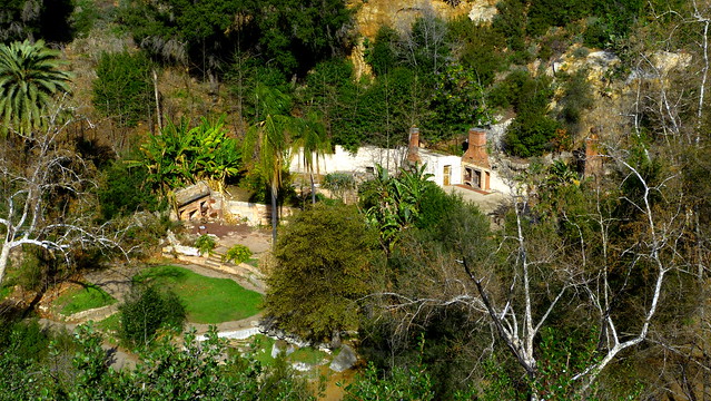
|
|
#
?
Jan 4, 2016 23:18
|
|
|
Has anyone been to the Murphy's Ranch trail in awhile? I went a few years ago but I have heard that since then people have been getting trespassing tickets there now
|
|
#
?
Jan 5, 2016 01:42
|
|


|
HarryPurvis posted:I've had good look spotting birds along Solstice Canyon. Lots of nice scenery, ruins of homes along the way, waterfalls at the end, and a secret alcove if you know where to look. this looks really cool! i went up to chiquito falls this past weekend, it was really pretty ") i am a truly awful photographer unfortunately. i am a truly awful photographer unfortunately.  this last one is of the falls from a short distance away. no water, of course. this is california.  fun hike.
|
|
#
?
Jan 5, 2016 06:36
|
|
|
I recommend the hike above Pasadena to the old abandoned railway/powerstation.
|
|
#
?
Jan 8, 2016 07:50
|
|

|
French Canadian posted:Now is the time to desert hike. Go hike the abandoned trestle bridge east of San Diego. It's wild west as gently caress. Sadly, I haven't done the goat canyon trestle but it is on my to do list! It looks cool as poo poo. http://californiathroughmylens.com/goat-canyon-trestle Another fun hike day hike is ladder canyon in the Mecca Wilderness. It's about 4 miles round trip I think but the slots are super cool and painted canyon on the way out it is amazing. http://www.in-the-desert.com/laddercanyon.html
|
|
#
?
Jan 21, 2016 20:42
|
|

|
GopherFlats posted:Sadly, I haven't done the goat canyon trestle but it is on my to do list! It looks cool as poo poo. I so want to do Ladder Canyon. But the reputation for vehicle break-ins and vandalism at the trailhead is a big dissuasion for me.
|
|
#
?
Jan 21, 2016 22:47
|
|
|
I just did Abalone Cove a week ago, that is a fun and easy hike, but try to time it to be during low tide otherwise most of the tidepools will be underwater.
|
|
#
?
Jan 26, 2016 04:07
|
|

|
French Canadian posted:Now is the time to desert hike. Go hike the abandoned trestle bridge east of San Diego. It's wild west as gently caress. Secret Canyon? I ran out of water there once because it was a 16 mile hike in mid-August and 4 liters isn't enough for that when it's 90+ degrees out. You should totally do it, it's awesome.
|
|
#
?
Jan 26, 2016 05:51
|
|

|
HarryPurvis posted:I so want to do Ladder Canyon. But the reputation for vehicle break-ins and vandalism at the trailhead is a big dissuasion for me. Ladder Canyon is awesome, basically mini-Utah. It's definitely out in meth-wasteland territory, but even on the winter Thursday I went there were enough regular people around that I wouldn't worry much. My ancient Corolla needed help out of the deep sand about a mile short of the trailhead though, so 4WD or several friends would be a good idea.  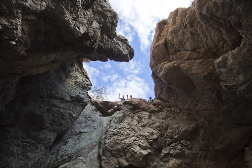 One of many cool little side canyons, if you're cool with class 3 there are a lot of places to explore off the main line. 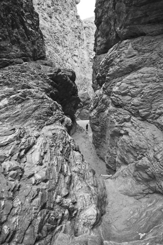 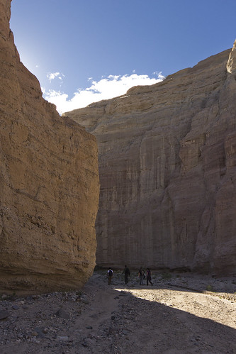
|
|
#
?
Jan 30, 2016 21:29
|
|
|
Alpenglow posted:Ladder Canyon is awesome, basically mini-Utah. It's definitely out in meth-wasteland territory, but even on the winter Thursday I went there were enough regular people around that I wouldn't worry much. My ancient Corolla needed help out of the deep sand about a mile short of the trailhead though, so 4WD or several friends would be a good idea. Literally mouthed 'woah' at that last one
|
|
#
?
Jan 31, 2016 01:47
|
|


|
I'm gonna hit Murphy Ranch next week before they tear part of it down. Not really very hike-like but it's a really cool spot and I'm sad it'll be diminished.
|
|
#
?
Feb 11, 2016 04:08
|
|
|
Has anyone done three sisters falls? I'm seeing a few places listing it as hard. It doesn't look tough outside some bouldering and maybe a couple steep inclines.
|
|
#
?
Feb 13, 2016 07:32
|
|
|
GopherFlats posted:Has anyone done three sisters falls? I'm seeing a few places listing it as hard. It doesn't look tough outside some bouldering and maybe a couple steep inclines. It's been 3 or 4 years since I've done it but it wasn't too bad. Steep, with a couple sections of rope. Pretty much just steep, and exposed if you go on a hot day, but the waterfall makes up for that.
|
|
#
?
Feb 17, 2016 00:14
|
|
|
GopherFlats posted:Has anyone done three sisters falls? I'm seeing a few places listing it as hard. It doesn't look tough outside some bouldering and maybe a couple steep inclines.
|
|
#
?
Apr 21, 2016 01:52
|
|

|
I want to hike up Mt. Baldy and I would like to try it in late May. Is there a webpage which lists the current trail conditions? I only need to know if there is snow or not. I have data for wind and temperature.
theHUNGERian fucked around with this message at 05:06 on Apr 24, 2016 |
|
#
?
Apr 24, 2016 04:56
|
|


|
theHUNGERian posted:I want to hike up Mt. Baldy and I would like to try it in late May. Is there a webpage which lists the current trail conditions? I only need to know if there is snow or not. I have data for wind and temperature. You can check Mt Baldy Ski lifts for a decent local report of the mountain. While they don't cover trail conditions, it is a good bet that if they have snow, the rest of the mountain does too. Honestly, barring any more significant storms Baldy will be snow free. I just went up yesterday and there were only small sheets of snow in the shady places, and larger sheets on the north facing slopes. My feet touched snow twice and that was only on the switchbacks past the ski hut. No snow at the summit but just over the ridge the north slope is still holding on to some larger sheets of snow and ice.
|
|
#
?
Apr 25, 2016 04:32
|
|
|
HarryPurvis posted:You can check Mt Baldy Ski lifts for a decent local report of the mountain. While they don't cover trail conditions, it is a good bet that if they have snow, the rest of the mountain does too. Excellent, thanks.
|
|
#
?
Apr 25, 2016 20:56
|
|
|
theHUNGERian posted:Excellent, thanks. Just a heads up that Baldy did get some snow today and may get a little more over the course of the rest of the week.
|
|
#
?
Apr 26, 2016 04:15
|
|
|
I'm considering a job in Santa Barbara. How's the hiking over yonder? I would expect it's good with the Santa Ynez mountains being right there. I'm probably going for an in person interview in mid May.
|
|
#
?
Apr 26, 2016 21:57
|
|


|
GopherFlats posted:Has anyone done three sisters falls? I'm seeing a few places listing it as hard. It doesn't look tough outside some bouldering and maybe a couple steep inclines. It's only hard if you don't take water. People leave SD early in the morning when it's nice and cool, and by the time they're hiking the steep uphill from the falls it's 95+ and there's no shade. People die on that trail every few years, and there are constant rescues. Basically if you're not a moron you'll be ok. Also like every trail in SoCal, it's crowded and people throw their water bottles and trash along the trail. Go early, go on a weekday if possible, and for god's sake use the turnouts on the way to and from to let other cars pass (I might live on that road). Also look for the dickwood tree:  And as for Goat Canyon Trestle, it is definitely a great hike. I hiked it 4-5 weeks ago, and some assholes had recently tagged/vandalized rocks along the trail all the way there and back. If you're going soon and feel like being cool, maybe take some rock-colored paints and try to hide that poo poo. (I have no idea if that would be considered illegal as well, so maybe don't unless you know it would be ok.)  
Watommi fucked around with this message at 00:31 on May 1, 2016 |
|
#
?
May 1, 2016 00:17
|
|

|
Awesome, thanks! So me and some buddies did cougar canyon today and it was amazing. I didn't realize how out of shape I was, once you get to the mouth it's bouldering all the way through a small running stream. Apparently it's 900' ascent in 1.5 miles. I had never been but I'm definitely making it a point to get back out to coyote canyon and the willows again once it cools down. Awesome scenery and some interesting looking hikes out there.
|
|
#
?
May 2, 2016 05:55
|
|
|
HarryPurvis posted:Just a heads up that Baldy did get some snow today and may get a little more over the course of the rest of the week. My trip is scheduled for May 20th, with a chance to cancel until May 16th. If there is excessive snow, I'll cancel my trip. If there is some snow, I'll just go ahead as planned, just to familiarize myself with the terrain. I can always come back for another attempt later in the year. Uranium 235 posted:I'm considering a job in Santa Barbara. How's the hiking over yonder? I would expect it's good with the Santa Ynez mountains being right there. I'm probably going for an in person interview in mid May. Even though I live here, I don't know that much about hiking here. All my favorite trails are on Santa Cruz island, so you would have to take a boat out. Those hikes are totally worth it ... and this is coming from somebody how has repeatedly puked his brains out on the boat ride to the island. World class diving too. I spent most of my outdoor time at night though, so you better come over here and see for yourself.
|
|
#
?
May 3, 2016 05:30
|
|
|
My Mt. Baldy hike is coming up in a week. How crowded should I expect it to be? It's still pretty cold so I don't expect many people, and I'll be doing the hike on a Friday. Are the trails as poorly marked as several web pages suggest?
|
|
#
?
May 14, 2016 06:37
|
|
|
theHUNGERian posted:My Mt. Baldy hike is coming up in a week. How crowded should I expect it to be? It's still pretty cold so I don't expect many people, and I'll be doing the hike on a Friday. Are the trails as poorly marked as several web pages suggest? The summit is more or less a social club by noon on the weekends. No idea how crowded it will be on a Friday but expect at least a few others up there. Depending on which trail you are following there might be a few tricky spots. - The backbone trail is the most clearly marked and easiest to follow. - If you're going up the ski hut trail the turn off from the fire road is easy to miss if you've never been there before. But once your on the ski hut trail it's clear sailing up to the bowl. From there the trail meanders a bit and splits and reconnects in places. Just follow the most well worn path and you should be good. - If your going up Register Ridge that's super easy to miss if you've never done it. First you have to find the ski hut turn off. Then after about 100 yards looks for a use trail to your right that looks like it's going straight up into some brush. - The trail from the village is clearly marked and easy to follow. And that's about the only easy thing about that trail. 6000' of gain in 6 miles is a real rear end-kicker. But I will say it is the prettiest trail up to the top. Have fun and post some shots when you get back!
|
|
#
?
May 14, 2016 16:23
|
|
|
HarryPurvis posted:The summit is more or less a social club by noon on the weekends. No idea how crowded it will be on a Friday but expect at least a few others up there. I was planning on doing the backbone trail going up, and the ski hut trail going down. This page made the ski hut trail seem tricky because signs were pointing in the wrong direction. Maybe I'll just do the backbone trail up and down. I'll post pictures if they turn out to be good. Thanks.
|
|
#
?
May 14, 2016 16:52
|
|
|
What winds are considered dangerous for Mt. Baldy? I read that in strong winds the Devil's Backbone hike is not advised because of steep slopes to the left and right of the trail. A wind forecast that I trust for my local area, suggests 35 mph winds (or just gusts?) for the day of my hike of Baldy Click. This is dangerously strong, right? Sorry for having hijacked this thread. Edit: I've cancelled my hotel reservation for this trip. Hopefully the weather will improve by next week, otherwise I'll have to reschedule for the middle of next month. theHUNGERian fucked around with this message at 03:29 on May 17, 2016 |
|
#
?
May 16, 2016 04:10
|
|
|
Yeah, the backbone would be scary with 35mph wind. It could also be considerably more than that with the ridge shape. I strongly prefer Ski Hut up and Backbone down to save knees. You also get to enjoy the desert views more with afternoon light and can get a beer or something at the ski lodge halfway back. It's also easy to find the trail at the top of the bowl, but descending to the ski hut it can be hit or miss if the winter really wrecked poo poo up.
|
|
#
?
May 17, 2016 16:27
|
|
|
theHUNGERian posted:What winds are considered dangerous for Mt. Baldy? I read that in strong winds the Devil's Backbone hike is not advised because of steep slopes to the left and right of the trail. A wind forecast that I trust for my local area, suggests 35 mph winds (or just gusts?) for the day of my hike of Baldy Click. This is dangerously strong, right? 35 isn't too bad. Even at its narrowest the backbone trail is still about 10 feet wide. Unless you have balance issues or a massive pack 35 mph might make you clench your sphincter, but should not be enough to be dangerous. And bear in mind, if thats the peak gust speed then the steady wind is probably around 20 or so and thats just a strong breeze (to me at least). What day are you planning to hike it? You mentioned going on a Friday to avoid crowds. Maybe we can meet up at the trailhead and I'll show you the ski hut trail.
|
|
#
?
May 17, 2016 17:21
|
|
|
HarryPurvis posted:35 isn't too bad. Even at its narrowest the backbone trail is still about 10 feet wide. Unless you have balance issues or a massive pack 35 mph might make you clench your sphincter, but should not be enough to be dangerous. And bear in mind, if thats the peak gust speed then the steady wind is probably around 20 or so and thats just a strong breeze (to me at least). Thanks for the offer. I'm not entirely sure when I'll hit the trail, so I'll have to decline. Re wind: I've hiked at altitude, I've been on long hikes, I frequently spend several hours in freezing temps ..., but I've never done all these things at the same time. A long hike at altitude in cold temps will already tax me. I worry that strong winds will make the whole thing unenjoyable. I'd rather wait for a calmer day next week because I have lots of flexibility with my vacation days.
|
|
#
?
May 17, 2016 20:12
|
|
|
ive never hiked to the hollywood sign, that poo poo it for tourists 
|
|
#
?
May 19, 2016 00:45
|
|

|
HarryPurvis posted:35 isn't too bad. Even at its narrowest the backbone trail is still about 10 feet wide. Unless you have balance issues or a massive pack 35 mph might make you clench your sphincter, but should not be enough to be dangerous. And bear in mind, if thats the peak gust speed then the steady wind is probably around 20 or so and thats just a strong breeze (to me at least). I just completed the hike. Devil's Backbone, out and back via that eyesore fire road to the Top of the Notch. Took me 4.5 hours to get up, another 3 to come down. When i reached the summit there were only 5 other people up there. Will post pics tomorrow.
|
|
#
?
May 24, 2016 01:35
|
|
|

|
| # ? May 1, 2024 17:56 |
|
|
Nooner posted:ive never hiked to the hollywood sign, that poo poo it for tourists im gonna go up there to see where homer smashed up the weather machine that time
|
|
#
?
May 24, 2016 05:17
|
|