- Adbot
-
ADBOT LOVES YOU
|

|
|
#
¿
May 20, 2024 23:52
|
|
- nwin
- Feb 25, 2002
-
make's u think


|
I did this a while back -- in fact I got significant symptoms from Covid later in the day, so sorta wasn't feeling doing this writeup in the recovery process.
RideWithGPS collaborated with UrbanDirt to put on the Cutty Cap Challenge. I think it was the 2nd year? The idea is to promote riding on dirt in a City Near You tm, using RWG, obviously.
A bunch of cities had 10 caps stashed in random places, curated by local bike scene people. This was the Boston layout:
https://ridewithgps.com/routes/39021644
It's rather literal, in the sense that it's confined to the Boston city limits, while most people would regard the cities on the north of the river as part of the Boston area. Boston proper is 675k people, while each of Cambridge and Somerville have 100k, to give a sense of scale. Though I totally buy an argument that the whole of Boston is underserved for weird bike events like this, and that there's nothing wrong with making the more affluent bike nerds up north do more riding to try to get these caps.
The perimeter of the map is 20mi, and some of the other cities had perimeters (for still only 10 caps) of 40 and even 60mi. So a much denser competition.
So that map was revealed at 9am on a Saturday, or 8am if you were a RWG member. I am, but having a toddler, I was not about to launch off at 8a for an hour or two trying to get a cap. My kid seemed up for going outside later in the morning, so I thought, why not, let's try to get the nearest cap.
I decided to go for the one in Jamaica Plain, on the Emerald Necklace bike path because a) I'm familiar with the area/route and b) it's one of the closest ones.

Set my phone GPS (wasn't about to charge up the Edge 800 for this) and got to work. Once I got close, I was staring at having to go off the grid to get to the GPS location:

So I knew it was somewhere between the two sides of the Emerald Necklace that I would normally ride, and had no idea what the terrain would be like or how to navigate to the point.
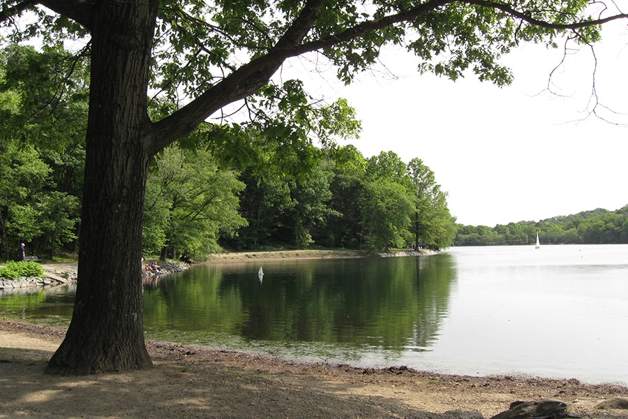
Some reference photos of the land around this part of the path:
It starts off right near Fenway Park in a pretty part of the city, where you can see apartments right off the path

Then it gets pretty lush pretty fast


You can see snapping turtles and turtles on the path all the time.
And eventually gives way to quite Thoreauesque scenery
So I'm biking up the left side of the path and spot a few possible trails, but they seem to be going downhill, and my clue,
made me think I needed to get a lot higher elevation. For locals, I was hitting the ramp on the path up into JP Center, so I though I should crest the hill and then turn into the woods.
But my phone showed I had gone past it, so I went back downhill and turned onto the dirt path I saw.
Eventually, I figured out the hill which seemed to be the one referenced in the clue. Unfortunately, it was a really short steep path on dirt. Well, urban dirt encountered. Time to hike a bike to see if it's urban paydirt.
I'm riding the 50lb cargo bike loaded with 40lbs of toddler and bike seat. And I decided to go casual, so am just chewing up the soft soil in my flip flops.
Another parent on a Tern GSD is taking two kids through a little tour on the path below, and calls up to me if I need help. I'm safe, though am not making much progress at the steepest, loosest part midway up the climb. I say I'm fine but don't try to offer an explanation of why I'm up here.
This is about 2/3 of the way up:

I'm always conservative about grades, but I think parts of this was steeper than 50%. Really tricky stuff.
Anyways, in the center of that picture, you can make out the tinge of the purple flowers. This was the moment where I was finally convinced I was in the right spot, and the extra adrenaline got me up the rest of the climb.
After leveling out, I dared to take a pic down the hill

I park the bike and unmount the babber to go find the cap and maybe get the moment on video.
The log bench seals it that this is the right spot.
https://i.imgur.com/nj0phiE.mp4
From 20ft out, I thought the white paper on the ground was maybe the package the cap was in, but by 10ft, I could tell it was someone taking a deuce up on this hill, with toilet paper, so I steer the toddler away from it.
Sweep the log to try to spot anything. Nope.

Even rooting around in the split part of the trunk, I don't find anything. Well, except for someone's weed stash:

A little bummed that it had been claimed (and not posted to RWG's social media to spare me trying to get this one), I put the toddler back on the bike and... walk down some steps instead of trying to rip down that hill.

This gave way to a gentler path down to a creek where we spent the next 30min or so goofing off and getting even dirtier.

I packed him up crying to keep playing with the water and took it easy on the way back home, where Covid would hit me full force (undoubtedly picked it up a few days prior on my company all hands trip in NYC).
All in all, I had a great time. The feeling of having some items physically spread out over a city, and being able to navigate to them, and deciding which one to go to and how to get there -- it was so congruous with playing missions in GTA, of all things.
The excitement of spotting some clue and knowing you're in the right place.
Getting the cap would have been very cool but it was an adventure without all that. Hopefully this challenge got some people who weren't connected to some of the rides their cities had to offer to go out there and enjoyed themselves.

Awesome write up! Too bad the perfume didn’t claim the cap though.
|
 #
¿
Jun 7, 2022 09:39
#
¿
Jun 7, 2022 09:39
|
|
- Adbot
-
ADBOT LOVES YOU
|

|
|
#
¿
May 20, 2024 23:52
|
|


 #
¿
Jul 26, 2020 13:00
#
¿
Jul 26, 2020 13:00


