


|
Count Roland posted:Wasn't there also a steady expansion south by Bantu peoples that had been going on for several centuries? Like there wasn't a worse point in time someone could happen across the Orange River basin than the time that they did, which proved convenient for anyone wanting to tell stories about either the 'empty south' or the inability of African people to govern. e: politically loaded maps  
Guavanaut fucked around with this message at 23:32 on Apr 26, 2023 |
 #
?
Apr 26, 2023 23:25
#
?
Apr 26, 2023 23:25
|
|


|

|
| # ? Jun 7, 2024 23:26 |
|
|
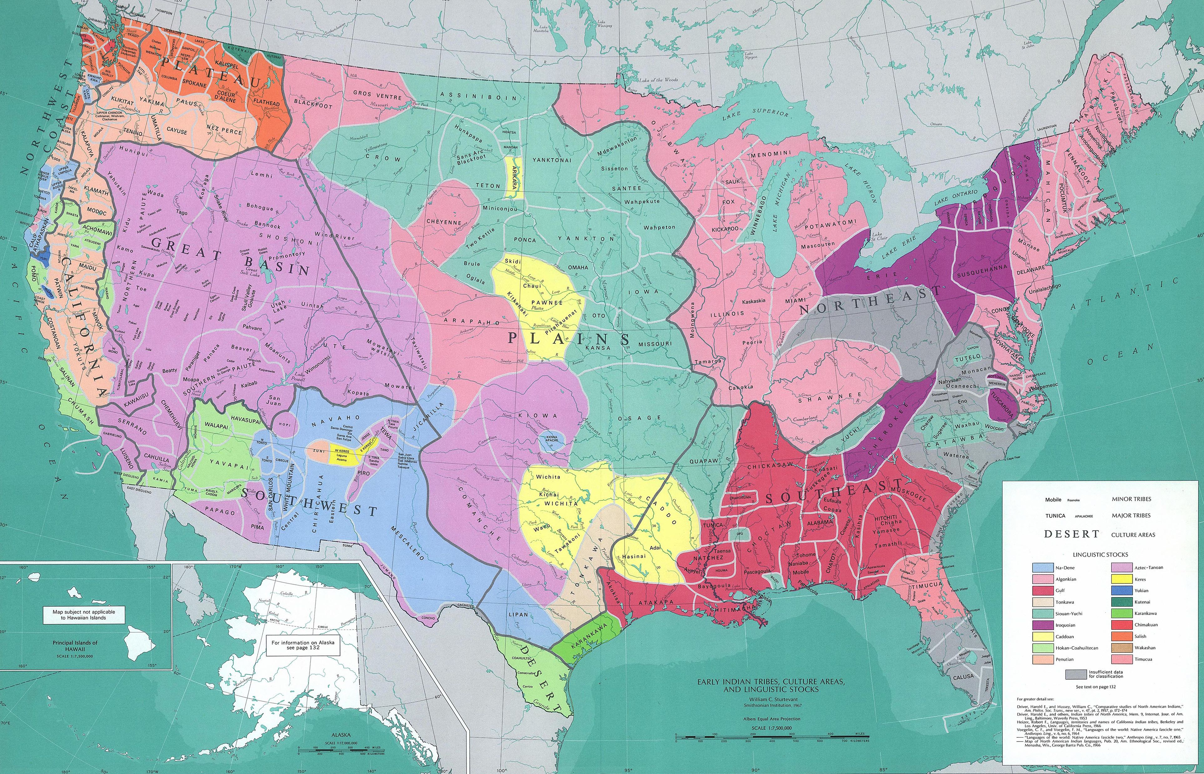
Albino Squirrel posted:It absolutely blows my mind that large sections of the Eastern US were so depopulated that nobody knows who lived there at the time of contact. The population collapse with the introduction of European diseases was so thorough that I've heard post-contact North America described as a collection of post-apocalyptic societies. The regions with insufficient areas aren't so much a result of total depopulation (although there was a lot of that happening) as they are a lack of information about the languages the inhabitants spoke. Linguistics wasn't a thing yet so there weren't people carefully documenting every local tribe's language.
|
|
#
?
Apr 27, 2023 00:13
|
|


|
Hey, map goons. I recently started a new job in the back room at a thrift store and when I saw this thing come in, I thought that this thread might enjoy picking on whatever the hell happened to Spain, Portugal, and Italy (the first thing I noticed). Also thin limp Florida. Sorry if any part of it is unreadable, it has very reflective paint, as you can tell. It's pretty big (it's leaning against a large shopping cart) and the wood was mostly still in good shape. I have no idea how old it is or who made it (the bottom right might be an artist signature, but I can't make it out). edit: Are the ridges mountain ranges and not just artistic bumps? Fifty Farts fucked around with this message at 01:17 on Apr 27, 2023 |
|
#
?
Apr 27, 2023 01:13
|
|

|
Vincent Van Goatse posted:The regions with insufficient areas aren't so much a result of total depopulation (although there was a lot of that happening) as they are a lack of information about the languages the inhabitants spoke. Linguistics wasn't a thing yet so there weren't people carefully documenting every local tribe's language. You do get early reports of smoke plumes dotting a seemingly-dense coast vs when the english start settling and it�s all god-given overgrown fields and orchards in New England
|
|
#
?
Apr 27, 2023 01:32
|
|

|
beats for junkies posted:Hey, map goons. I recently started a new job in the back room at a thrift store and when I saw this thing come in, I thought that this thread might enjoy picking on whatever the hell happened to Spain, Portugal, and Italy (the first thing I noticed). Also thin limp Florida. Tag your favorite feature! Mine's the Philippine.
|
|
#
?
Apr 27, 2023 02:00
|
|


|
beats for junkies posted:Hey, map goons. I recently started a new job in the back room at a thrift store and when I saw this thing come in, I thought that this thread might enjoy picking on whatever the hell happened to Spain, Portugal, and Italy (the first thing I noticed). Also thin limp Florida. RIP South Korea
|
|
#
?
Apr 27, 2023 02:02
|
|


|
I�m the Panama strait
|
|
#
?
Apr 27, 2023 04:09
|
|

|
blaccaspian sea
|
|
#
?
Apr 27, 2023 05:44
|
|

|
No New Zealand, of course.
|
|
#
?
Apr 27, 2023 07:00
|
|

|
I like the little Baja California nipple.
|
|
#
?
Apr 27, 2023 07:12
|
|


|
beats for junkies posted:edit: Are the ridges mountain ranges and not just artistic bumps? Just artistic
|
|
#
?
Apr 27, 2023 07:20
|
|

|
beats for junkies posted:Hey, map goons. I recently started a new job in the back room at a thrift store and when I saw this thing come in, I thought that this thread might enjoy picking on whatever the hell happened to Spain, Portugal, and Italy (the first thing I noticed). Also thin limp Florida. that's a pretty good map given that it was made by some dude with a soldering iron
|
|
#
?
Apr 27, 2023 11:19
|
|

|

|
|
#
?
Apr 28, 2023 10:11
|
|
|
Turkey and Ethiopia and Thailand being no-data
|
|
#
?
Apr 28, 2023 10:50
|
|

|
VictualSquid posted:Turkey and Ethiopia and Thailand being no-data Iran and Afghanistan, too.
|
|
#
?
Apr 28, 2023 10:54
|
|


|
You see that a lot on speculative European maps from that era, "countries that we failed to colonize but are unlikely to go Russia or China so just put ???"
|
|
#
?
Apr 28, 2023 11:12
|
|
|
 Seen in Asian restaurant in EU.
|
|
#
?
Apr 28, 2023 11:47
|
|


|
alex314 posted:
That balalaika is huge 
|
|
#
?
Apr 28, 2023 11:52
|
|

|

|
|
#
?
Apr 28, 2023 13:11
|
|
|
Ah yes the famous China-Japan alliance
|
|
#
?
Apr 28, 2023 14:37
|
|
|
Kamrat posted:Nations: I always find these maps weird, as if the linguistic groups didn't overlap, or as if there was any real concept of a nation state. I mean maybe Native Americans didn't get around as much as Greeks or Phoenicians? Whenever I see these I get the impression they're as misleading as trying to put an ethno-linguistic map on any period of Mediterranean history from between like 1000 BC and 1800. I don't know much about it (and perhaps no one does), but I really doubt Native Americans were generally genocidal hard-border nationalist maniacs. The bottom one at least looks like it could be realistic. The top one must be replete with poor quality data from hundred of different years all mixed up together, since the years at which they have the east coast tribes labeled would be like 1600, vs the west coast would be like 1850. Like putting together a map of WW2 Europe mixed up with some War of the Roses stuff. E: Basically I am saying that upper map is this: 
Saladman fucked around with this message at 15:19 on Apr 28, 2023 |
|
#
?
Apr 28, 2023 15:17
|
|

|
What time period is this and what political leanings? It has post WWI borders for Germany / Austria, but it seems to give far too leeway to the British / Americans / Russians, and too little credit to Italy to be made by Nazis. On the other hand it assumes that China's gonna be conquered by Japan? Which would be against the Weimar policy, along with the more obviously problematic "conquer France and all our former colonies" pickle. jeebus bob posted:Ah yes the famous China-Japan alliance I think you'll find none of those block are exactly built on foundations of brotherly love.
|
|
#
?
Apr 28, 2023 15:18
|
|


|
steinrokkan posted:What time period is this and what political leanings? I'm not sure of the author's political leanings, it seems to fit into the wild Atlantropa school of "there's definitely going to be a strong Eurafrican alliance in the future (Euros at the top ofc) but the Brits and Russians will be outside of it." Not sure who has conquered who in the Ostasien sphere, or if it's more a mutual pact, or if the author is just being racist and assumes that the 'yellow races' will be one of the world poles. (it's not like we haven't seen the latter from some far more modern speculative maps, "yeah, the sino-japanese-korean sphere, that makes sense")
|
|
#
?
Apr 28, 2023 15:26
|
|
|
steinrokkan posted:What time period is this and what political leanings? It has post WWI borders for Germany / Austria, but it seems to give far too leeway to the British / Americans / Russians, and too little credit to Italy to be made by Nazis. On the other hand it assumes that China's gonna be conquered by Japan? Which would be against the Weimar policy, along with the more obviously problematic "conquer France and all our former colonies" pickle. Sure but the others least had an established relationship, however unequal it may have been: US plus its hegemony over South America, UK and its colonies, the rest of Europe and their colonies, Russia et al. China+Japan as a united bloc is nonsense, regardless of when the map was made
|
|
#
?
Apr 28, 2023 15:33
|
|
|
Like so: Most interesting thing is the difference between the 1920s nonsense and 2020s nonsense, like the assumption that Africa is 'naturally' split into British and European spheres (and Ethiopia) vs the assumption that it is split into African and Islamic spheres, or panamericanism vs everything south of the Rio Grande is Latin.
|
|
#
?
Apr 28, 2023 15:37
|
|
|
jeebus bob posted:Sure but the others least had an established relationship, however unequal it may have been: US plus its hegemony over South America, UK and its colonies, the rest of Europe and their colonies, Russia et al. I mean, I'm sure some Japanese around the time would disagree about their right and ability to make it so  And Wang Jingwei's puppet government followed earlier attempts to fund Japan-controlled Chinese government during the warlord era.
|
|
#
?
Apr 28, 2023 15:41
|
|
|
Politically loaded because only one of those three men is Japanese.
|
|
#
?
Apr 28, 2023 15:46
|
|
|
Guavanaut posted:Like so: because of the size/simultaneous contrast it was hard for me to see if they put bosnia and albania in the islamic (?) cultural sphere, or if they were doing an asterisk-style "all the world was subjugated by a large cultural block. all? no, two autochthonous nations hold out" thing
|
|
#
?
Apr 28, 2023 15:47
|
|
|
Guavanaut posted:Politically loaded because only one of those three men is Japanese. None of them are Japanese, is the point, the man in the middle is the aforementioned Wang Jingwei. It's a poster announcing that his Japanese-formed Chinese government is recognized as legitimate by other... world luminaries. So regardless of whether they ever managed it, controlling China via proxies was very much on Japanese agenda. steinrokkan fucked around with this message at 15:55 on Apr 28, 2023 |
|
#
?
Apr 28, 2023 15:52
|
|
|
jeebus bob posted:Sure but the others least had an established relationship, however unequal it may have been: US plus its hegemony over South America, UK and its colonies, the rest of Europe and their colonies, Russia et al. For a map made in 1920 its no more nonsense than a Franco-German union, or a Finland and Spain union. They're all about as crazy as each other at the time.
|
|
#
?
Apr 28, 2023 16:07
|
|

|
Richard von Coudenhove-Kalergi, who made the map, was a pan-European nationalist. He was one of those people who had very contrarian views that were a product of his time. So like, he rejected the Eugenicist view that race mixing would dilute the blood of the white race by arguing that race mixing was Good, Actually. And his response to claims that the Jews were running the world was "What if the Jews are just better at running things than you idiots?"
|
|
#
?
Apr 28, 2023 16:09
|
|

|
Guavanaut posted:Like so: Europe/Asia: Meticulously drawn borders ensuring even the smallest country is placed into its correct category Africa: "Whatever, just draw a horizontal line, this ain't rocket surgery"
|
|
#
?
Apr 28, 2023 16:29
|
|
|
Powered Descent posted:Europe/Asia: Meticulously drawn borders ensuring even the smallest country is placed into its correct category
|
|
#
?
Apr 28, 2023 16:31
|
|


|
AAAAA! Real Muenster posted:On one hand, yeah, but on the other that is, as far as I understand it, essentially the dividing line for where people follow Islam, regardless of national borders. It's weird that they did trace the northern border of Senegal to put it in the African sphere, despite Senegal being 97% Muslim.
|
|
#
?
Apr 28, 2023 16:35
|
|
|
Napoleon Nelson posted:It's weird that they did trace the northern border of Senegal to put it in the African sphere, despite Senegal being 97% Muslim. that's because it's a map of perceived skin colour
|
|
#
?
Apr 28, 2023 16:43
|
|


|
Saladman posted:I always find these maps weird, as if the linguistic groups didn't overlap, or as if there was any real concept of a nation state. I mean maybe Native Americans didn't get around as much as Greeks or Phoenicians? Whenever I see these I get the impression they're as misleading as trying to put an ethno-linguistic map on any period of Mediterranean history from between like 1000 BC and 1800. I don't know much about it (and perhaps no one does), but I really doubt Native Americans were generally genocidal hard-border nationalist maniacs. There was some kind of an idea of a nation state, most notably with the bigger societies like the Aztecs, Incans, or Iroquois. The Aztecs were pretty notable in their harshness towards their enemies, which was part of how the Spanish could easily partner with the Aztecs' enemies to overthrow the empire. Most Native American societies were sedentary agricultural societies, which naturally creates some kind of territorial claims; they may have not had borders on maps in the same way we do now, but the idea of borders on maps as opposed to just keeping track of territorial claims in vaguer ways (like claiming specific towns, valleys, or just "this side of a river") only caught on in Europe after the popularity of deep sea navigation created the popularity of the idea of maps in the first place. Many native american groups after Columbus became nomadic, after the devastation of disease left it more feasible to just hunt and gather across the many newly vacant lands, but even nomads can be territorial. The Comanche worked out a whole seasonal path of where they went throughout the year, they had a clear "territorial zone" that others could not go into without their knowledge (although the Comanche in other ways don't exactly meet the definition of a state). There's plenty of native american on native american wars and conquest and even some kinds of vassalage, but most people don't learn about them because they're often not especially relevant to the modern day. There's a lot about pre-depopulation American societies we don't really know and can only guess at from mixed archeological data and accounts from spanish expeditions that were exploring all over the drat place back in the day. There were a lot of misunderstandings with Europeans over power structures, and even later on when there were lengthy treaties with native americans over territory, there would still be misunderstandings, arguably often intentional.
|
|
#
?
Apr 28, 2023 16:45
|
|

|
Saladman posted:I always find these maps weird, as if the linguistic groups didn't overlap, or as if there was any real concept of a nation state. I mean maybe Native Americans didn't get around as much as Greeks or Phoenicians? Whenever I see these I get the impression they're as misleading as trying to put an ethno-linguistic map on any period of Mediterranean history from between like 1000 BC and 1800. I don't know much about it (and perhaps no one does), but I really doubt Native Americans were generally genocidal hard-border nationalist maniacs. Nations in this context means a shared culture, not a nation-state
|
|
#
?
Apr 28, 2023 16:46
|
|
|
CommonShore posted:that's because it's a map of perceived skin colour 100%, the actual muslim line in the sahel is a couple hundred miles south in west africa and way weirder in east africa
|
|
#
?
Apr 28, 2023 16:53
|
|
|
SlothfulCobra posted:spanish expeditions that were exploring all over the drat place back in the day.
|
|
#
?
Apr 28, 2023 16:54
|
|
|

|
| # ? Jun 7, 2024 23:26 |
|
|
AAAAA! Real Muenster posted:Holy poo poo piss that is way more inland and north pacific coast exploration than I knew they did. I could look at this thing for hours. it's interesting seeing the lack of dates in the 1600s and early 1700s
|
|
#
?
Apr 28, 2023 17:18
|
|