


|
Inceltown posted:You can probably still buy that map - or at least one exactly like it - on Amazon. Yeah, you can very easily get reproduction of maps going pretty far back:  https://www.etsy.com/au/listing/615929817/antique-world-map-vintage-style-print Older maps may not be that accurate, but they do look pretty drat sweet. Always wanted one with sea monsters randomly drawn in the unknown sea parts. The day cartographers stopped doing that was a sad day indeed. 
|
 #
?
Apr 27, 2024 10:50
#
?
Apr 27, 2024 10:50
|
|


|

|
| # ? Apr 28, 2024 20:24 |
|
|
Man I am resisting the urge to go nuts spending on old maps and vintage books.
|
|
#
?
Apr 27, 2024 11:00
|
|
|
I would be extremely sus of someone specifically buying a map of Rhodesia tbh
|
|
#
?
Apr 27, 2024 11:09
|
|

|
Our little primary school had a good set of maps by the redoubtable Chas. H. Scally of Wollstonecraft. In particular this one intrigued me: Looking at the Northern Territory, it would seem the 3 biggest towns are Darwin, Alice Springs and Rum Jungle, so for 30 years that was all I knew of the NT. But a couple of years ago we went driving around up there, and actually went through Rum Jungle, which is about 3 houses, a BP and 2 dogs. Why did it get such real estate on the map? Also we had this great old world map, very commonwealth-heavy. That solar system diagram is burned into my brain. 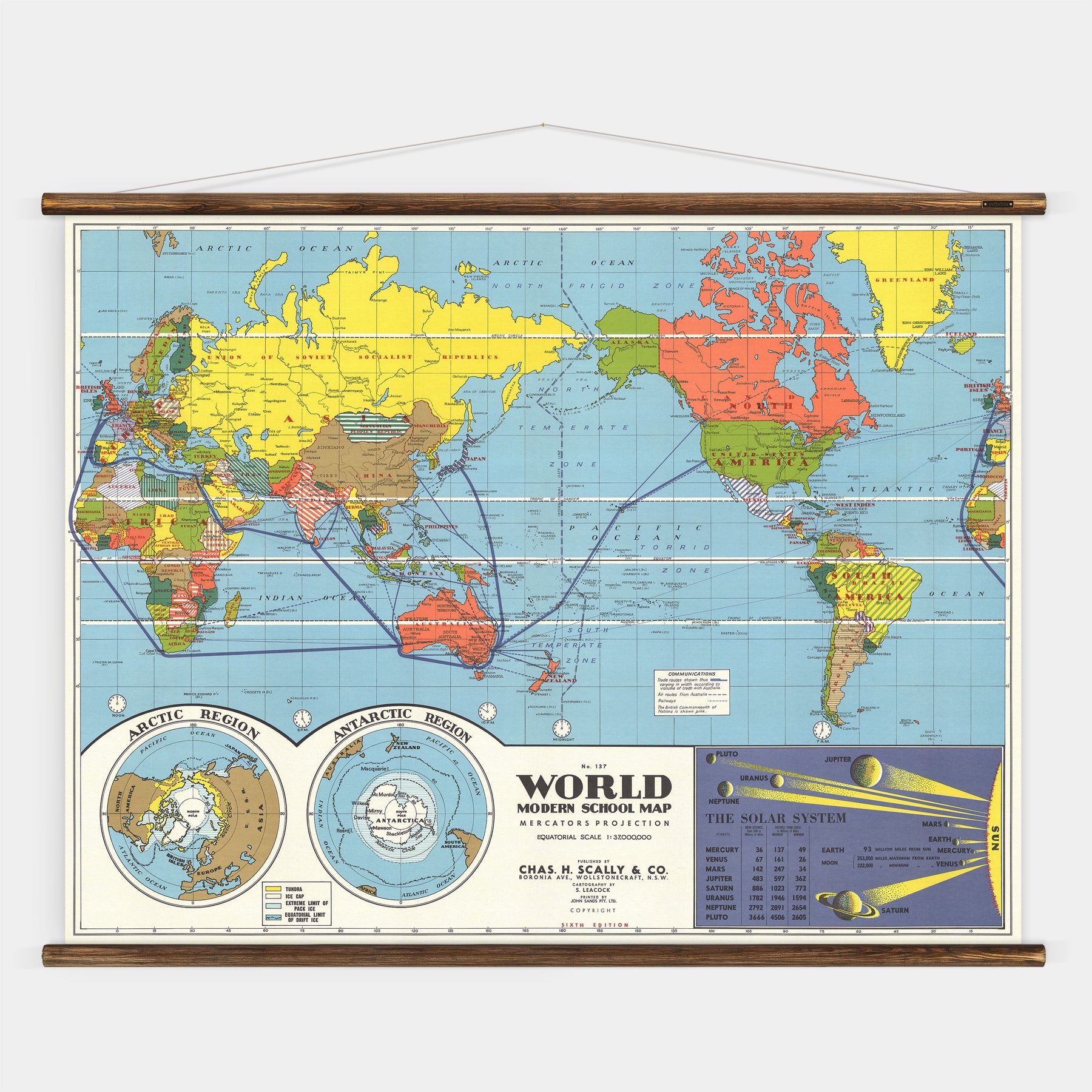
|
|
#
?
Apr 27, 2024 11:28
|
|

|
Ye olde map weirdness is a fascinating topic, there's a lot of bizarre stuff and a lot of it persisted until shockingly recently, such as this weird anomaly on google maps: https://www.youtube.com/watch?v=PVemGumEEgo It turns out that a lot of the dumb hosed up stuff was caused by Captain Cook  Here's one about how the border between NSW, SA and Vic got all hosed up by cartographers: https://www.youtube.com/watch?v=WEtPzt6v6UI webmeister posted:Pretty sure the atlas I grew up reading still featured Rhodesia Rhodesia was still a country when I was a kid 
|
|
#
?
Apr 27, 2024 11:43
|
|
|
Chikos go pretty good in an air fryer btw
|
|
#
?
Apr 27, 2024 11:51
|
|

|
I used to have a book that I can't remember the title of. It was a history of all the island that only existed on maps due to gently caress up's by the sailors when they were charting islands back in the day. Quite a few of them had lots of interesting mystery and rumours about them due to sailors not being able to find them, due to you know them not actually existing. Sometimes people would "find them" as usually the phantom map islands were just another somewhat near by island of coastline that the person making the original chart saw and then they just put it in the wrong place.
|
|
#
?
Apr 27, 2024 11:53
|
|
|
theres probably freaks out there that collect old street directories
|
|
#
?
Apr 27, 2024 11:59
|
|


|
dr_rat posted:I used to have a book that I can't remember the title of. It was a history of all the island that only existed on maps due to gently caress up's by the sailors when they were charting islands back in the day. Quite a few of them had lots of interesting mystery and rumours about them due to sailors not being able to find them, due to you know them not actually existing. That video I posted about phantom islands covers a lot of them. Shackleton's 1909 attempt to reach the south pole is a highlight because their voyage back to South America was planned around rest stops at four islands dotted throughout the south pacific and they got severely hosed over when it turned out that none of these islands actually existed
|
|
#
?
Apr 27, 2024 12:05
|
|
|
Snowglobe of Doom posted:Ye olde map weirdness is a fascinating topic, there's a lot of bizarre stuff and a lot of it persisted until shockingly recently, such as this weird anomaly on google maps: From memory the WA-SA border doesn�t quite line up with the WA-NT border either, for basically the same reason. Though it�s closer than the NSW-VIC-SA border
|
|
#
?
Apr 27, 2024 12:16
|
|
|
webmeister posted:From memory the WA-SA border doesn�t quite line up with the WA-NT border either, for basically the same reason. Though it�s closer than the NSW-VIC-SA border Yeah both borders were supposed to lie exactly along the 129th meridian east longitude but the agreement that the PM and the state premiers signed in the 1920s stated that this would be a line running north/south between the Kimberley Obelisk and the Deakin Obelisk, two cartographic markers which were also supposed to be placed exactly on 129� 00'00" but which turned out to be at 128� 59'57" and 129� 00'018", which ended up created a 127m difference at the southern-most border of NT https://en.wikipedia.org/wiki/Surveyor_Generals_Corner
|
|
#
?
Apr 27, 2024 18:03
|
|
|
Chrpno posted:Our little primary school had a good set of maps by the redoubtable Chas. H. Scally of Wollstonecraft. In particular this one intrigued me: Whats the small green section under NSW where Melbourne is? Is that another Territory? E: thats Victoria, never mind Also, my friend (mate) from Straya is from Belrose in NSW, What is some embarrassing poo poo I can ask him about? wesleywillis fucked around with this message at 21:56 on Apr 27, 2024 |
|
#
?
Apr 27, 2024 18:39
|
|


|
Melbournes Live Music Scene Over 50 Years
|
|
#
?
Apr 27, 2024 23:41
|
|


|
wesleywillis posted:Also, my friend (mate) from Straya is from Belrose in NSW, What is some embarrassing poo poo I can ask him about? Ask him why he chooses to live on the Insular Peninsula
|
|
#
?
Apr 28, 2024 00:26
|
|
|
wesleywillis posted:Whats the small green section under NSW where Melbourne is? tony abbot is from belrose
|
|
#
?
Apr 28, 2024 00:27
|
|

|
Some of the people who live in the Riverland near where the 3 states meet feel really strongly about where the SA/Vic border should be lol
|
|
#
?
Apr 28, 2024 01:32
|
|


|

|
|
#
?
Apr 28, 2024 09:38
|
|

|
why is it upside down i need mr blackboard
|
|
#
?
Apr 28, 2024 10:17
|
|
|
Missing a whole continent
|
|
#
?
Apr 28, 2024 10:19
|
|
|
Vladimir Poutine posted:Missing a whole continent Antarctica is losing sea ice so fast now that the map is more accurate.
|
|
#
?
Apr 28, 2024 11:16
|
|
|
pictures from my little bushwalk     
|
|
#
?
Apr 28, 2024 11:53
|
|
|
Sisters Beach?
|
|
#
?
Apr 28, 2024 12:43
|
|

|
How did you know?
|
|
#
?
Apr 28, 2024 12:46
|
|
|
He was definitely not stalking you
|
|
#
?
Apr 28, 2024 13:05
|
|
|
I got real good at tracking down people�s rock fishing spots using photos they�d taken
|
|
#
?
Apr 28, 2024 13:06
|
|
|
In your case the sun was setting to the left as you face the water, so it was the north coast of somewhere not very tropical looking. The rest was pretty easy to work out on google maps satellite images
|
|
#
?
Apr 28, 2024 13:10
|
|
|
it's the god drat metadata isn't it
|
|
#
?
Apr 28, 2024 13:10
|
|
|

|
| # ? Apr 28, 2024 20:24 |
|
|
I would blow Dane Cook posted:it's the god drat metadata isn't it imgur strips the metadata
|
|
#
?
Apr 28, 2024 20:20
|
|