


|
That shows what I know about the French language. 
|
 #
?
Apr 1, 2013 16:57
#
?
Apr 1, 2013 16:57
|
|


|

|
| # ? May 17, 2024 10:01 |
|
|
Actually the city names in the French-occupied bit of Germany are weird. They're literal translations of the German names, not the names actually used in French (those are mostly just the original names, sometimes spelled a bit differently). I guess the map's maker really hates all things German.
|
|
#
?
Apr 1, 2013 17:15
|
|

|
Why is Austria not marked as �sterreich? Also, Great Netherlands looks like normal Netherlands with a horrific tumor 
|
|
#
?
Apr 1, 2013 17:23
|
|

|
GreenCard78 posted:Are the French names in their English corruptions of French? At least France itself? Aix-La-Chapelle, Francfort, Mayence, Fribourg are correct French names, others like "Charlesrepot" or "Sarreponts" are wrong.
|
|
#
?
Apr 1, 2013 17:40
|
|

|
System Metternich posted:
Not bizarre. Lots of Norwegian whalers were whaling whales in the south Atlantic when there were no whales left in the north.
|
|
#
?
Apr 1, 2013 17:55
|
|


|
Kurtofan posted:Aix-La-Chapelle, Francfort, Mayence, Fribourg are correct French names, others like "Charlesrepot" or "Sarreponts" are wrong. Whoever made the map changed the German place names to whatever language the other countries use, but not very well. The "Dutch" place names for German cities are wrong as well, e.g. the Dutch name for Dortmund is Dortmond, not Daarmond.
|
|
#
?
Apr 1, 2013 17:58
|
|
|
System Metternich posted:A map of Bouvet Island, an uninhabitated island off the coast of Antarctica that for some bizarre reason belongs to Norway. The best thing about Bouvet Island is that it somehow has its own country code TLD, .bv, although no one is allowed to use it.
|
|
#
?
Apr 1, 2013 18:02
|
|

|
ekuNNN posted:Why is Austria not marked as �sterreich? The Austrians are now Italians, like the ones in South Tirol , no more Germans ever.
|
|
#
?
Apr 1, 2013 18:06
|
|

|
prefect posted:What language is that map in? Is every country labeled using their native languages? That was my first guess, but the seas don't belong to any one nation, so I'm not sure what the standard is. Hamborg is correct though, so there's that at least. Pretty sure it wasn't a Dane that made the map at least, perhaps more so because we just got back our kings' old territory, while everyone else is just spilling out all over the place. Maybe an Italian given the names in Austria?
|
|
#
?
Apr 1, 2013 18:26
|
|


|
twoday posted:
So the Dutch offered the French the city of Aachen ("Aix-la-Chapelle") under the requirement that they'd have to move the whole place 50km to the south?
|
|
#
?
Apr 1, 2013 18:59
|
|


|
Schisser posted:So the Dutch offered the French the city of Aachen ("Aix-la-Chapelle") under the requirement that they'd have to move the whole place 50km to the south? Mighty generous of them. Though I can't see why the French would want all that extra land beyond the Rhine.
|
|
#
?
Apr 1, 2013 19:03
|
|


|
If I remember correctly, that map was published in a German satirical magazine in response to anti-German sentiment in Germany. For an actual plan to divide up Germany there is always the Morgenthau Plan. Unfortunately, Wikipedia only has maps that look like they were made in MS Paint and are difficult to read. QuoProQuid fucked around with this message at 19:17 on Apr 1, 2013 |
|
#
?
Apr 1, 2013 19:13
|
|


|
Here is a German version: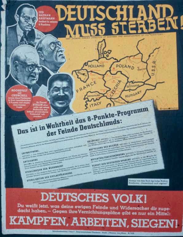 Also, I love this: 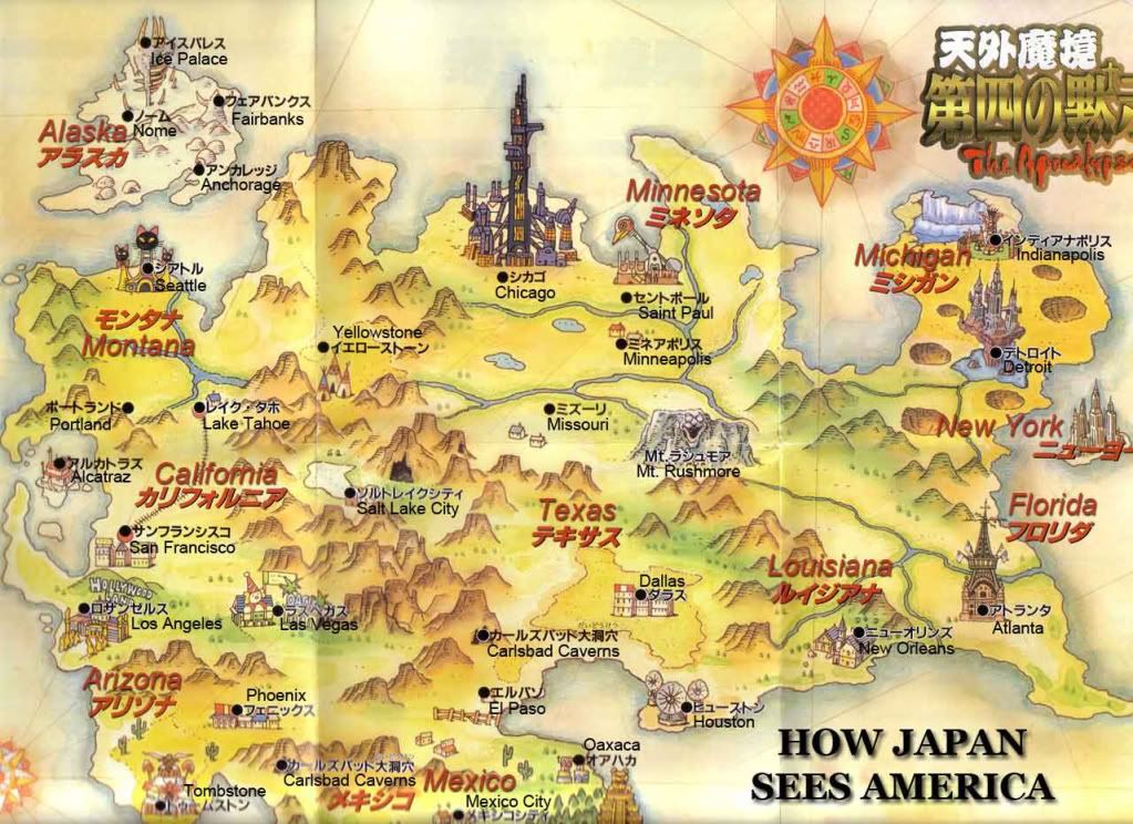
|
|
#
?
Apr 1, 2013 19:16
|
|


|
twoday posted:Here is a German version:
|
|
#
?
Apr 1, 2013 19:34
|
|
|
twoday posted:
This is hurting my brain
|
|
#
?
Apr 1, 2013 20:23
|
|

|
And Hungary is still getting stiffed on ethnic Hungarian regions in Novi Sad and at the Slovakian border.
|
|
#
?
Apr 1, 2013 20:32
|
|

|
twoday posted:
What's the context of this map? Was this part of a historical plan, or is it just anti-German dreaming or what?
|
|
#
?
Apr 1, 2013 20:34
|
|


|
twoday posted:Also, I love this: Can't figure out if the two cottages represented near Missouri are supposed to be the Cahokia mounds, or if St. Louis was planned on being bombed to the ground to the point of nothing left. Not really sure why, in the case of aeronautics we've got Scott AFB close by, Lambert Airport (a huge regional airport), and a bunch of research and industrial capabilities both for civilian and defense purposes. Not to mention our totally bitchin' Gateway Arch, would could be then renamed at the Tokugawa Imperial Expansion Memorial. (real name of the Arch is the Jefferson National Expansion Memorial, I suppose it'd be a welcome change for the Japanese Empire) edit: Also, why is Chicago *west* of Minnesota? Bastaman Vibration fucked around with this message at 21:01 on Apr 1, 2013 |
|
#
?
Apr 1, 2013 20:58
|
|
|
twoday posted:
That looks too much like China to be a coincidence.
|
|
#
?
Apr 1, 2013 21:07
|
|

|
dinoputz posted:Can't figure out if the two cottages represented near Missouri are supposed to be the Cahokia mounds, or if St. Louis was planned on being bombed to the ground to the point of nothing left. Not really sure why, in the case of aeronautics we've got Scott AFB close by, Lambert Airport (a huge regional airport), and a bunch of research and industrial capabilities both for civilian and defense purposes. Not to mention our totally bitchin' Gateway Arch, would could be then renamed at the Tokugawa Imperial Expansion Memorial. (real name of the Arch is the Jefferson National Expansion Memorial, I suppose it'd be a welcome change for the Japanese Empire) It's also a gigantic dystopian factory city, which isn't terribly far from the truth in some wards, though I just checked out my window and was unable to locate bladerunner tower.
|
|
#
?
Apr 1, 2013 21:10
|
|


|
Chicago was a big hub for North American flights to/from Japan so it isn't surprising that that might have warped impressions of travelers who passed through it, of course the whole map is a bad joke so who knows.
|
|
#
?
Apr 1, 2013 21:12
|
|


|
dinoputz posted:Also, why is Chicago *west* of Minnesota?
|
|
#
?
Apr 1, 2013 21:12
|
|


|
The map is like that because its from an RPG, jeez guys. You know what they like. Tengai Makyou: Daishi no Mokushiroku, or the "Fourth Apocalypse".
|
|
#
?
Apr 1, 2013 21:20
|
|
|
Nuclearmonkee posted:It's also a gigantic dystopian factory city, which isn't terribly far from the truth in some wards, though I just checked out my window and was unable to locate bladerunner tower. We need to build that tower, like now
|
|
#
?
Apr 1, 2013 21:53
|
|

|
Muscle Tracer posted:What's the context of this map? Was this part of a historical plan, or is it just anti-German dreaming or what? If I remember correctly, that map was published in a German satirical magazine in response to anti-German sentiment in Germany.
|
|
#
?
Apr 1, 2013 22:22
|
|
|
Farecoal posted:We need to build that tower, like now The Willis tower's brutalism isn't good enough for you. 
|
|
#
?
Apr 1, 2013 22:45
|
|

|
There are 2 Carlsbad Caverns on that map, maybe one is an entrance and the other is an exit...
|
|
#
?
Apr 1, 2013 23:02
|
|

|
Dang how did they find out about the top secret Ice Tower.
|
|
#
?
Apr 1, 2013 23:10
|
|
|
Ardennes posted:The Willis tower's brutalism isn't good enough for you. What the gently caress  No really
|
|
#
?
Apr 1, 2013 23:20
|
|
|
From googling "how sees the world" "How God sees the world"   I remember this on the stands        Have a link   
|
|
#
?
Apr 1, 2013 23:22
|
|
|
In 1954 Leopold Kohr, Austrian political scientist and self described philosophical anarchist, published The Breakup of Nations. The book protested what he called the "cult of bigness". There is a general desire for expansion and Kohr argued that all the world's problems could be traced back to one power becoming too powerful. The division of the United States was perfect as no one state was large enough to dominate the others or cause much harm. To illustrate his ideas, he drew an idealized version of Europe based strongly on US borders. This, in his mind, was what Europe should strive for:  He realized, however, that dividing Europe into rectangular states would clash with the �tribal� makeup of the continent�s culturally diverse peoples. He proposed the following borders: 
|
|
#
?
Apr 1, 2013 23:32
|
|
|
Ardennes posted:The Willis tower's brutalism isn't good enough for you. The Sears Tower is International Style.
|
|
#
?
Apr 1, 2013 23:37
|
|
|
System Metternich posted:
 e; a map of Antarctica have probably already been posted, but just in case: 
Kainser fucked around with this message at 23:44 on Apr 1, 2013 |
|
#
?
Apr 1, 2013 23:41
|
|

|
While there are many bases in Antarctica, most of them have been built with total disregard for territorial claims, and just for scientific interests, but Chile has bases built there for the sole purpose of making it seem like normal Chilean cities, with 1000+ residents, including children and schools for those children, and grants citizenship to anyone born there. Nevertheless the people there have to live in 6-month shifts, to keep them humane.
|
|
#
?
Apr 1, 2013 23:58
|
|
|
I can't believe that North Korea or Turkmenistan or someone else hasn't already jumped on the unclaimed zone.
withak fucked around with this message at 00:02 on Apr 2, 2013 |
|
#
?
Apr 1, 2013 23:58
|
|


|
I think that these claims were made before a UN treaty banning further claims and declaring it a neutral territory, so I think these countries are all just sitting on these earlier claims and waiting for that treaty to be abolished.
|
|
#
?
Apr 2, 2013 00:11
|
|
|
Dusseldorf posted:The Sears Tower is International Style. Imagine a skyscraper made out of beige/tan concrete.
|
|
#
?
Apr 2, 2013 00:14
|
|
|
Why would Taiwan consider America an Evil Empire? Aren't we the ones who sell them all their weapons so Big China can't just waltz in there?
|
|
#
?
Apr 2, 2013 00:17
|
|

|
Ammat The Ankh posted:Why would Taiwan consider America an Evil Empire? Aren't we the ones who sell them all their weapons so Big China can't just waltz in there? Turns out that crazy-rear end nationalists generally aren't very happy with their country being a de facto protectorate. Or the entire thing could just be satirical, what do I know.
|
|
#
?
Apr 2, 2013 00:32
|
|
|

|
| # ? May 17, 2024 10:01 |
|
|
Farecoal posted:Imagine a skyscraper made out of beige/tan concrete. Oh god sorry, Sears tower. So whats a good way to tell, use of concrete versus glass and steel?
|
|
#
?
Apr 2, 2013 00:38
|
|