|
My guess would be the river in the eastern part of the "donut" is Nile, and the vertical appendage is the Arabian Peninsula.
|
 #
?
Aug 3, 2013 09:29
#
?
Aug 3, 2013 09:29
|
|


|

|
| # ? May 17, 2024 06:13 |
|
|
Fizzil posted:Maududi, this image was flipped, but note the arabic is upside down here. That's not too bad except for Southern Africa being a separate continent for some reason. When was it made?
|
|
#
?
Aug 3, 2013 11:20
|
|


|
Lord Hydronium posted:Also notable, the year it was made: 1492. Right before people were about to realize that that big ocean between Europe and Japan shouldn't be empty: This is actually my favourite thing about the whole "Columbus proved the world was round" myth. Part of the reason he had such a hard time getting funding for his trip was not that everyone thought the world was flat, it was that everyone knew the world was round, and more importantly, knew pretty much exactly how large the earth was. Columbus incorrectly believed the world was much smaller than it actually is, which is why he thought it might be possible to reach the Orient by sailing west, and everyone else quite correctly held the view that this would be impossible because you'd have to sail over half the circumference of the Earth in a single trip without stopping to get from the Azores to the Spice Islands. And there was no real reason to just assume there'd be a continent in the middle of that sea. Everyone was perfectly justified in assuming that Columbus' voyage was a suicide mission because his beliefs on the size of the Earth had already been proved wrong millennia before he was even born. And of course, Columbus went to his grave believing that he had reached the Indies and proven that the world was smaller than it actually was. Which must have made all the people saying "you obviously discovered a new continent, dingus" really annoying for him!
|
|
#
?
Aug 3, 2013 11:44
|
|

|
RE : Chinese map posted by Lawman 0 I don't think that the 'donut peninsula' is even as far as the middle east. First of all, the map doesn't seem to be north-south, but east(ish, a bit more to the south)-west(ish, a bit more to the north). The top of the map is the west, and the bottom the east. There aren't any names of places to go by, but this is what it looks like to me (right/north to left/south) The big peninsula is Korea, with the islands of Jeju and Tsushima just off the coast. The sea to the north is the Yellow sea, with the Bohai sea even further north. Beijing is the little white castle linked to the sea by a small delta of 3 rivers. Below the "Korean peninsula" there are 3 small islands. This is probably Japan. Scale is hugely off, but as you'll see, this isn't going to be abnormal for this map. The dominant river in the middle of the map is the Yangtze or Chang Jiang, which goes from Shanghai to (according to the author) the foothills of the Tibet plateau. The lakes on the south (left) of the Yangtze are probably Taihu, Poyang and Dongting lakes. The Yangtze should go pretty much straight "up" on the map, but due to inaccuracies, the author has actually only followed the lower loop pretty correctly (Shanghai to Jiujiang), and then just continued in a straight line rather than make it loop West several times. The Yellow river is conspicuously absent from this map, despite being the 6th largest river system in the world. I don't know exactly when this map was made, but a possible reason is that the river has changed course several times in recorded history, with courses that ranged from as far north as Beijing to further south than the Shandong peninsula, meaning the author preferred to note the several "possible" paths, but without singling any one out, or even that the map was drawn in a period when the course of the Yellow river was uncertain (war period, period of heavy floods), and as such the author simply couldn't pinpoint where the Yellow river would flow. Another possible reason is that this map was drawn before Emperor Yongle transferred the capital to Beijing, and thus centers on the area around the capital at that time, Nanjing, which is on the Yangtze river (and meant that the far north reach of the empire, where the Yellow river is, might have been less familiar to the author). The island in the middle of the great sea at the bottom of the map is Taiwan. Further to the left there are two islands, one close to the mainland (Hainan), and the further one is possibly the Philippines. After this the map gets very, very inaccurate, and is probably based on fragments of maps that existed before, tales by merchants and other travelers, and maps that aren't centered around rivers (which this map is). The peninsula to the left (not yet the 'africa-middle east' peninsula) looks like it could be the Indochina peninsula, but with the thai peninsula missing, and therefore also all of Indonesia. Perhaps the map was based on a territorial map of a ruler in the peninsula (present-day Thailand or Vietnam) for tributary payments, but the author didn't understand that the map didn't represent all the territories in the peninsula. The peninsula is very mountainous which is consistent with either Vietnam or Western Thailand. The "Arabia-Africa" peninsulas therefore become Bangladesh and India. The "Red Sea" is actually the Ganges delta, which is very, very inaccurate. The rivers that lead north of here are mapped in quite good detail, but the mountain ranges they take source from should actually also be the Himalayas, albeit the "Indian side", and in some cases the western reaches of the Himalayas. The mountains at the south of India? The Cardamoms or the Nilgiris, which are pretty high hills/mountains (quite a lot over 2000m). No idea what the huge lake in India would be though, unless it's some sort of mangled representation of the monsoon's flooding? Perhaps the Chinese equivalent of "Here be dragons?", I don't know. Sure this interpretation is a long way from the official interpretation (Africa, little bits of Europe, Mediterranean (not filled in, mind you), Arabian peninsula...). But I find it hard to explain how the Chinese would forget some very nearby things on their maps (where is the Indochina peninsula in that case? or India? where is the Dalian peninsula if what I interpret as Korea is Japan?) and at the same time be quite good on things that are very, very far away (coastlines of Africa and Arabia, mountains in south africa, italy, plenty of rivers in eastern europe and the middle east...).
|
|
#
?
Aug 3, 2013 11:46
|
|

|
Shazback posted:The Yellow river is conspicuously absent from this map, despite being the 6th largest river system in the world. I don't know exactly when this map was made, but a possible reason is that the river has changed course several times in recorded history, with courses that ranged from as far north as Beijing to further south than the Shandong peninsula, meaning the author preferred to note the several "possible" paths, but without singling any one out, or even that the map was drawn in a period when the course of the Yellow river was uncertain (war period, period of heavy floods), and as such the author simply couldn't pinpoint where the Yellow river would flow. Another possible reason is that this map was drawn before Emperor Yongle transferred the capital to Beijing, and thus centers on the area around the capital at that time, Nanjing, which is on the Yangtze river (and meant that the far north reach of the empire, where the Yellow river is, might have been less familiar to the author). The yellow river is there, in fact it is one of the most prominent features of the map because it is the only river drawn in yellow. It's just hard to see on the low-res version of the map which has been posted because it is drawn in yellow instead of blue. But if you look closely even at that small version (look at the fold in the centre, then find the yellow line running bottom left to top right across the fold) you can definitely see its course following a general left-to-right (i.e. west-to-east) direction. Your theory is beautiful, but it is not correct I'm afraid.
|
|
#
?
Aug 3, 2013 12:02
|
|
|
Squalid posted:Another alternative is that the map isn't even trying to depict geography and is making some kind of symbolic point, like medieval christian maps that depict Jerusalem as the center of the world. Is this a map or is it a work of art? Because the way I would define "map" is something you can use to navigate, which that doesn't really help you do, or something that depicts at the very least what someone thinks a geographic feature looks like, and I don't think anyone actually thought the world looked like that. It's a political cartoon or something. Badger of Basra fucked around with this message at 19:02 on Aug 3, 2013 |
|
#
?
Aug 3, 2013 18:57
|
|


|
Boiled Water posted:Shouldn't it be Africa and not Italy? I thought it was India, myself.
|
|
#
?
Aug 3, 2013 19:28
|
|

|
Badger of Basra posted:It's a political cartoon or something.  But really, why not consider the three-continents picture a map? It doesn't show where things "really" are for navigational purposes, but I don't see how to exclude this as a map, while including all the politically loaded thematic maps we've been posting. It's like one of those maps that shows countries sized by population, or something, except here the scheme is more philosophical.
|
|
#
?
Aug 3, 2013 21:37
|
|
|
Sorry for the late replies, I completely forgot about this threadPhlegmish posted:Normally I would agree that maternity leave is the last thing you want to start applying austerity to in a country experiencing a terminal demographic crisis, but two years does seem crazy. Are you serious about that? I think it's four months in Belgium. Well in Belgium I guess you can afford to put newborn babies in daycare/hire a cheap immigrant to care for them, but here with our salaries if you don't have a retired mother/relative available and you're poor, you'd be pretty screwed without that maternity leave. And it's mandatory for employer only Squalid posted:Whoa, that's unexpected. Could you explain how French has had such a big impact on a language so distant from the French state? During late 18th - early 20th century when romanian nationalism took off (like in all other countries around) and the romanian state gained independence and expanded, France was seen as the greatest country in the world, had the best literature by far, greatest city etc. so all of the romanian elite were sending their children to be educated in Paris. This led to many generations of francophones who would even speak french at home and among themselves, use french words or expressions freely in conversation, and so on. Even among the lower classes that had an education, french was by far the most common second language, french literature the most read, and romanian writers borrowed heavily from french ones (like my fave romanian author, Camil Petrescu, whose "Patul lui Procust" is basically a romanian version of "A la recherche du temps perdu"). Bucharest was nicknamed "little Paris", France was seen as our big brother, we were more francophone than the french themselves. Then after WW2 and the arrival of communism, there was a short period of sovietization when russian began to be taught on a large scale, but after the romanian leaders (especially Ceausescu) started a more independent/nuanced policy, they cultivated some heavy nationalism that centered a lot on a cult for our "forefater" the Roman Empire (complete with Roman statues everywhere, Roman names on everything, etc). And since French already had a tradition and was a latin language, it came back as the most taught foreign language. But funny enough, the fall of communism in '89 also meant a gradual fall of French way behind English. And with Spanish* and Italian gaining ground fast, French (both language and culture) is probably gonna lose even more ground. *The reasons for the popularity of Spanish in Romania are interesting and pretty funny: for the last 20 years south american telenovelas have been hugely popular, and with romanian tv/cinemas using subtitles instead of dubbing, there's an entire generation of romanian women/girls with tv-taught spanish. Plus the big popularity of reggaeton, Shakira, etc. Oh and of course there's the many romanians who consider themselves "latinos" and view mexicans, cubans and so on as "brothers" Jerry Cotton posted:Yes but it would be reasonable to expect they wouldn't need to. It's not that simple, it's true that any slavic influence was seen as barbaric, dirty and backwards while western (french) influence was preferable, but there's also the issue of romanian language being vowel heavy and very close to latin, so to romanian ears a french/italian word tends to sound much better than an alien-sounding slavic import. That meant that the romanian vocabulary of slavic origins fell from 25-30% to under 10%, and the slavic words that survived were heavily romanised/latinised (most times with dropping consonants/adding vowels; we really love vowels). And not only slavic words fell victim to french/italian ones, there were also many words of direct latin origin that also got replaced. So, even if the intention was kinda there, it wasn't a large scale conspiracy to remove slavic influence, it happened mostly naturally.
|
|
#
?
Aug 4, 2013 00:49
|
|

|
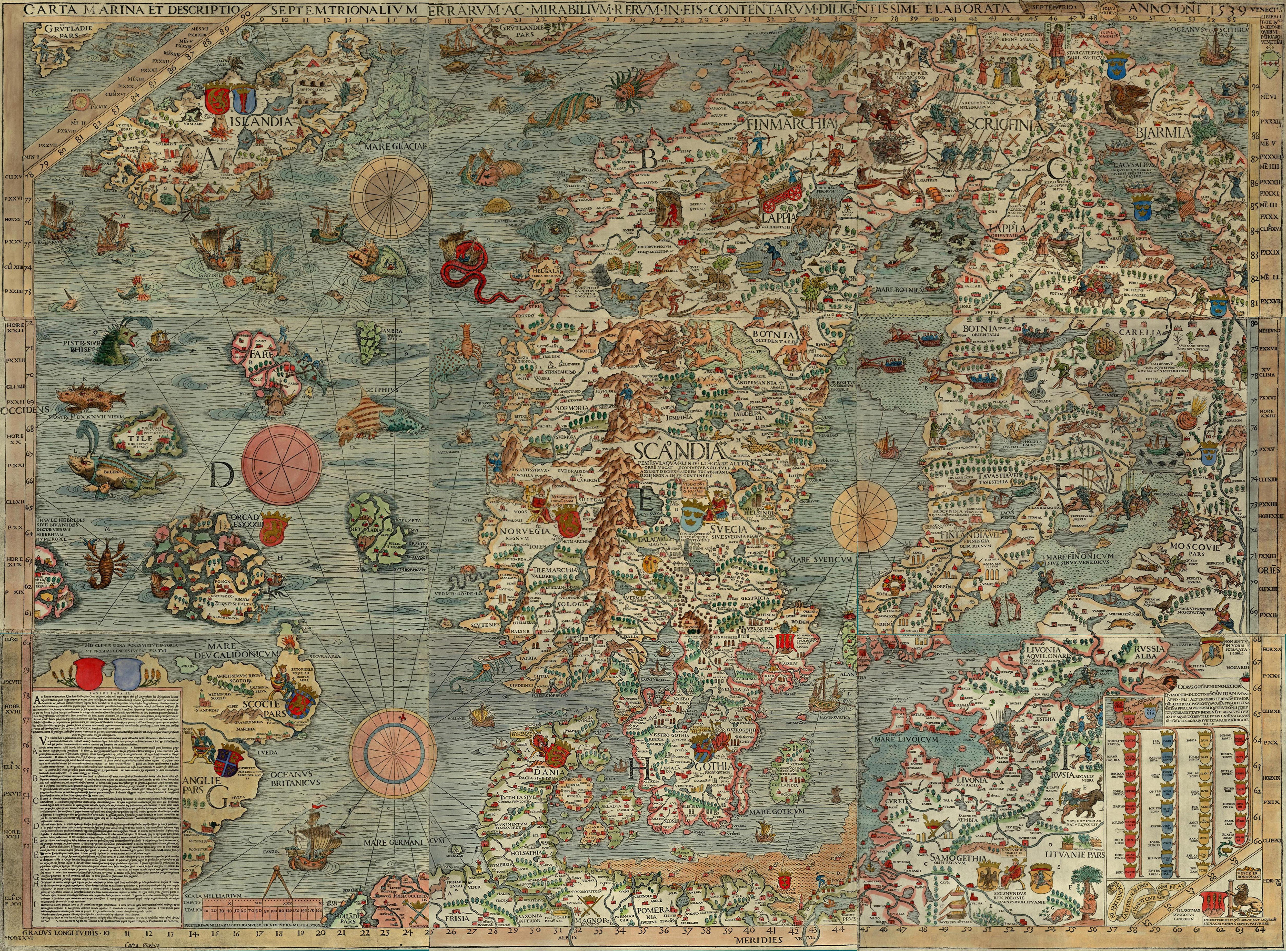
Lord Tywin posted:Here's a 16th century map of the Nordic countries e: \/ That's cool as heck. 
unlimited shrimp fucked around with this message at 02:39 on Aug 4, 2013 |
|
#
?
Aug 4, 2013 02:01
|
|
|
Ofc. Sex Robot BPD posted:Why does it say 'Chaos' over parts of Iceland? Those are probably volcano caves, realms of Norse fire giants. quote:In a book from the Prose Edda additional information is given about Surtr, including that he is stationed guarding the frontier of the fiery realm M�spell, that he will lead "M�spell's sons" to Ragnar�k, and that he will defeat Freyr.
|
|
#
?
Aug 4, 2013 02:30
|
|

|
Ofc. Sex Robot BPD posted:Why does it say 'Chaos' over parts of Iceland? Chaos is the latin term for the underworld. It seems like the lower one could be meant to refer to mount Hekla, which was considered to be a gateway to hell.
|
|
#
?
Aug 4, 2013 02:36
|
|
|
rzeszowianin 44 posted:Those are probably volcano caves, realms of Norse fire giants.
|
|
#
?
Aug 4, 2013 02:39
|
|
|
This seems like a good place to ask, since I haven't been able to find the answer to this anywhere else. Balboa is credited as the first European to discover the Pacific Ocean from the east, and Magellan for naming it. But Europeans had already encountered the Pacific from the west, as the big ocean east of Japan and the Philippines. So what did they call that ocean? Did they just consider it the other side of the Atlantic?
|
|
#
?
Aug 4, 2013 04:04
|
|


|
I'm pretty sure there was a map posted on the previous page that showed a big ocean seperating Europe and Asia, so yeah, they just thought the Atlantic was a lot bigger than it was. E: here it is: 
|
|
#
?
Aug 4, 2013 04:11
|
|
|
Nyarlothotep posted:I'm pretty sure there was a map posted on the previous page that showed a big ocean seperating Europe and Asia, so yeah, they just thought the Atlantic was a lot bigger than it was.  I just wasn't sure whether they ever actually called it the Atlantic on the Asian side, or if they treated each side as its own thing. I just wasn't sure whether they ever actually called it the Atlantic on the Asian side, or if they treated each side as its own thing.
Lord Hydronium fucked around with this message at 04:24 on Aug 4, 2013 |
|
#
?
Aug 4, 2013 04:22
|
|
|
Lord Hydronium posted:Yeah, I posted that. If you read the map, they called the ocean on the Japanese side the Great Indian Ocean, the southern part of the Atlantic was the Southern Ocean and the northern part/what is now the Arctic ocean was the Eastern Ocean ")
|
|
#
?
Aug 4, 2013 04:31
|
|

|
Phlegmish posted:That's not too bad except for Southern Africa being a separate continent for some reason. When was it made? This particular map is 20th century, drawn off an older map. I can only guess that they encountered a river and considered it a sea instead, or a huge lake.
|
|
#
?
Aug 4, 2013 05:16
|
|


|
Bishop Rodan posted:As a bonus, this it what the Chinese thought the people of "Daqin" looked like: You can see he's holding a box of coral, because the Chinese knew they got their red coral from Rome. Of the Eight Treasures, a list of most-prized stuff in ancient China, none of them are found in China proper. The closest is jade, which was sourced from what is now western China but which has never been culturally Chinese and for most of history was not politically Chinese either. Red coral was in such high demand that Roman coral-collectors would throw iron chains overboard into the coral beds, to make more coral turn bright red. Also worth a mention is asbestos cloth, which the Chinese thought was made of unicorn hair. The surprising* omission from the list is Roman glassware, which we know was exported to China. This is an annoying Chinese cultural/historiographical habit: they love making lists of the 4 This and the 10 That. For example, the American Great Lakes are known in China as the Five Great Lakes. It's annoying because these lists quickly come to be thought of as exclusive. If it's not one of the Eight Treasures it must not be that great, right? I once heard a Chinese scholar on the history of Hangzhou (an ancient and storied Imperial vacation city) that the worst thing that ever happened to Hangzhou was someone writing down the "10 Must-See Sites of Hangzhou", which was practically a death-warrant for every interesting thing not on the list. The phrasing is unfortunately almost inescapable due to the Chinese language's lack of pluralization; thus without the Five Great Lakes we would be left with just the Great Lake. This is compounded by "one of the" being an unwieldy and rarely-used phrase in Chinese. Anyway, that's why Roman glassware, the best examples of which are still stunningly masterful to modern eyes, is not counted on the list of treasures despite being an import attested by archeological records. I should mention that there is a list of the 100 Treasures, but nobody knows them off the top of their heads because there are 100 of them. *okay, not that surprising I guess when there's only 10 slots and the list is unofficial, but the list-making is still annoying Bishop Rodan posted:I really find it interesting to see what China thought of the West in the time before the Age of Discovery and trade routes being established. I mean, in the West you always hear what the West thought of China, for obvious reasons, but you never really hear the opposite. Of course, I can't read Chinese, so unless there are some translated sources there's no way I'd know anyway. The Chinese spent less time thinking about the West than vice versa. The Chinese "thing" is sort of being the center of the world and dismissive towards foreigners. Unfortunately for China, this attitude only became more and more engrained through the Late Imperial period when the Ming dynasty might have had a shot at the exploration game themselves. The only really cosmopolitan native dynasty was the Tang, which was contemporaneous to the Dark Ages in Europe and thus paid no attention to the benighted continent. The Qing were an interesting bunch, but not Chinese (no matter what modern Chinese people tell you) and dismissive of Europeans more because they were a minor presence than because of a lack of interest in foreign cultures. By the time contact with the West really became impossible to ignore in the Victorian era the Qing were embroiled in massive internal upheavals, so it's hard to separate signal from noise in their dealings with the West. Most simple and reasonable explanations of the late Qing involvement with foreigners are false for that reason; the late Qing was not a simple or reasonable time. Arglebargle III fucked around with this message at 07:41 on Aug 4, 2013 |
|
#
?
Aug 4, 2013 07:37
|
|

|
Roman glass was a big deal because it was a technology the Chinese had zero knowledge of, they could make glass beads but that was it--clear glass, blown glass, those were Roman inventions. It was also one of the few trade goods they would actually accept, mostly they just took gold/silver in exchange for silk. Glass was valuable enough that it could be exported as well. It didn't all stay in China either, a bunch has been dug up here in Korea and recently some was found in Japan. How the Romans eventually got their own silk industry going under Justinian is a fun story worth looking up. Secret agents!
|
|
#
?
Aug 4, 2013 07:45
|
|


|
John Nance Garner posted:And the 10th ballot, after shifts, which officially nominated one Warren Gamaliel Harding, for President: From a couple of pages back, but why is the Philippines in there? Was it part of the political process while it was a colony/Commonwealth?
|
|
#
?
Aug 4, 2013 12:54
|
|

|
Grand Fromage posted:How the Romans eventually got their own silk industry going under Justinian is a fun story worth looking up. Secret agents! Is it as ridiculous as how a clearly Scottish guy pretended to be Chinese somehow and thus stole the secrets of the Chinese tea industry?
|
|
#
?
Aug 4, 2013 20:33
|
|

 Yes, it's like a lava lamp.
|
I'm just imaging some huge guy with a huge red beard bowing quite a bit.
|
|
#
?
Aug 4, 2013 20:45
|
|
|
Arglebargle III posted:This is compounded by "one of the" being an unwieldy and rarely-used phrase in Chinese. How does this manifest in Chinese? How would "Lake Erie is one of the Great Lakes" (or an equivalent like "Lake Erie is a Great Lake") be translated?
|
|
#
?
Aug 4, 2013 21:42
|
|

|
Edible Hat posted:How does this manifest in Chinese? How would "Lake Erie is one of the Great Lakes" (or an equivalent like "Lake Erie is a Great Lake") be translated?
|
|
#
?
Aug 4, 2013 21:45
|
|
|
"Lake Erie is a Great Lake" translates as 伊利湖是个大湖. The problem with that is twofold: 1. There isn't really a way to signal proper nouns in Chinese. In English capitalization is used (Great Lake instead of great lake), but beyond punctuations there isn't something like that in Chinese. So imagine reading "Lake Erie is a great lake". 2. ...EXCEPT the character for "great" is also that for "big". So now you're reading "Lake Erie is a big lake". "Lake Erie is one of the Great Lakes" is less problematic. It translates as 伊利湖是五大湖其中之一, which is literally: Lake Erie is Five Great Lakes, Of Which One. It's only four more characters which I don't think is especially cumbersome, but it's certainly more elegant in English.
|
|
#
?
Aug 4, 2013 22:10
|
|
|
gradenko_2000 posted:From a couple of pages back, but why is the Philippines in there? Was it part of the political process while it was a colony/Commonwealth? Yeah even though the territories don't get votes in the Electoral Congress, both the main parties let them vote in primaries/caucuses and the convention. The Republican party, more progressive than the actual US Government. Example, the 2008 Democratic Primaries: 
|
|
#
?
Aug 4, 2013 23:19
|
|
|
Why are Texas and Texas Caucus are different colors?
|
|
#
?
Aug 5, 2013 03:36
|
|

|
Because its mother loving Texas thats why.
|
|
#
?
Aug 5, 2013 03:37
|
|
|
 50 States Ordered by Penis Size New Hampshire Oregon New York Indiana Arizona Hawaii Louisiana Massachusetts Alabama Washington New Mexico California Arkansas Nevada Virginia Tennessee Illinois Oklahoma South Dakota Georgia Pennsylvania Mississippi Michigan Florida Rhode Island Kansas Maryland Minnesota Vermont Connecticut Wisconsin New Jersey North Dakota Idaho Texas Missouri Montana Ohio Nebraska Colorado Maine North Carolina Delaware South Carolina Kentucky West Virginia Alaska Iowa Utah Wyoming http://www.dailyfinance.com/2010/03/26/condom-maker-breaks-down-penis-size-by-state-city/
|
|
#
?
Aug 5, 2013 04:08
|
|

|
duodenum posted:
Chocolate City.
|
|
#
?
Aug 5, 2013 04:59
|
|

|
wdarkk posted:Why are Texas and Texas Caucus are different colors? Because I don't think the delegates are actually bound to vote for the people chosen by the electorate. That's why the last Republican primary had tons of idiots trying to get delegates elected who would actually just vote for Ron Paul. But I'm not American, so I don't follow these things super-closely, and I might be way off base there.
|
|
#
?
Aug 5, 2013 06:38
|
|
|
PittTheElder posted:Because I don't think the delegates are actually bound to vote for the people chosen by the electorate. That's why the last Republican primary had tons of idiots trying to get delegates elected who would actually just vote for Ron Paul. But I'm not American, so I don't follow these things super-closely, and I might be way off base there.
|
|
#
?
Aug 5, 2013 07:18
|
|
|
PittTheElder posted:Because I don't think the delegates are actually bound to vote for the people chosen by the electorate. That's why the last Republican primary had tons of idiots trying to get delegates elected who would actually just vote for Ron Paul. But I'm not American, so I don't follow these things super-closely, and I might be way off base there. That just applies to the actual presidential election and not the primaries AFAIK. They try that because it's worked before. The single electoral college vote the Libertarian Party has ever received in their history came from a delegate who had pledged to vote for Nixon even though the Libertarian party had only received a few thousand votes in the popular vote nationwide.
|
|
#
?
Aug 5, 2013 08:52
|
|
|
PittTheElder posted:Is it as ridiculous as how a clearly Scottish guy pretended to be Chinese somehow and thus stole the secrets of the Chinese tea industry? Pieshe of cake. 
3D Megadoodoo fucked around with this message at 07:40 on Aug 6, 2013 |
|
#
?
Aug 5, 2013 10:09
|
|

|
lonelywurm posted:Apparently, from looking at Wikipedia, Texas actually had two sets of delegates - one set was determined by the primary vote on March 4th, and the other was determined by a series of three rounds of voting with progressively fewer delegates. Clinton won the primary, and Obama won the delegate votes. Yes. Its called the 'Texas two step.' The GOP had something similar is Missouri this year, though the caucus was nonbinding
|
|
#
?
Aug 5, 2013 14:30
|
|
|
duodenum posted:
Awful lot of big dicks in DC...
|
|
#
?
Aug 5, 2013 16:23
|
|


|
BNBG Thought I should explain this one a bit so I don't get banned: BNBG is police slang in DC and Maryland and that region over there so I thought it might be fitting to make a joke along those lines. I of course do not support the use of racial stereotypes in police work; but I do think jokes about racial stereotypes in police work are funny and apt and not a bannable offence. Thank you, god bless you; and may god bless the United States of America. Baloogan fucked around with this message at 20:04 on Aug 5, 2013 |
|
#
?
Aug 5, 2013 18:58
|
|
|
The Real Quaid posted:Very cool. Here is similar style Chinese map from 70 years later, they had got quite a bit better at getting the world geographically accurate in that time. From the last page, but this map is pretty cool; unless I've got something horribly wrong, the characters for America literally read a-me-ri-c(k)a, with north- and south- added in the appropriate places.
|
|
#
?
Aug 5, 2013 19:41
|
|
|

|
| # ? May 17, 2024 06:13 |
|
|
Teddles posted:From the last page, but this map is pretty cool; unless I've got something horribly wrong, the characters for America literally read a-me-ri-c(k)a, with north- and south- added in the appropriate places. Confirming North and South, but I can't speak to the others.
|
|
#
?
Aug 5, 2013 19:49
|
|