


|
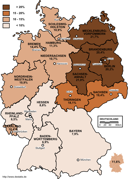
What is that, poverty rates?
|
 #
?
Oct 30, 2013 01:10
#
?
Oct 30, 2013 01:10
|
|


|

|
| # ? May 27, 2024 15:18 |
|
|
Sorry, unemployment.
|
|
#
?
Oct 30, 2013 01:17
|
|


|
It would be interesting to see what the population density of Germany is with a map using similar (or near similar) metrics.
|
|
#
?
Oct 30, 2013 03:35
|
|

|
Backweb posted:It would be interesting to see what the population density of Germany is with a map using similar (or near similar) metrics. This should be fairly easy to follow:  (the legend refers to people per square km, darker colors are more dense) edit: I found this here.
|
|
#
?
Oct 30, 2013 03:37
|
|

|
A lot of the East German states seem to have very low population densities. For example, Brandenburg (the region around Berlin) has less than 2.5 million inhabitants. I'm not sure if it's a historical thing or if it's related to the demographic collapse of the last two decades. I also imagine that most of the German refugees from Eastern Europe settled in West Germany after WWII, for obvious reasons.Davincie posted:It was the same thing when I was in Estland. Most of the 'trophy wives' all had expensive fur around their necks too even if it was in the middle of a ridiculous heat wave. Those women were probably ethnically Russian as well. I'm always surprised that Russian/Ukrainian men don't seem to mind the Western phenomenon of import brides very much, or our stereotype of Eastern European prostitutes. I'd expect it to be ground for nationalistic grievances or to trigger calls for a moral awakening. Phlegmish fucked around with this message at 09:38 on Oct 30, 2013 |
|
#
?
Oct 30, 2013 09:31
|
|


|
Phlegmish posted:Those women were probably ethnically Russian as well. What makes you think they don't mind? I'm a bit further west from Russia/Ukraine, but anti human-trafficking PSAs were quite common here until very recently and when the capital city became a popular stag-do destination in the mid-2000s, there was a whole lot of resentment, even though the actual damage had been done throughout the 90s and the first half of the 2000s.
|
|
#
?
Oct 30, 2013 10:09
|
|

|
I don't know, you don't seem to hear much about it. Maybe it's because the physical differences between Western and Eastern Europeans usually aren't obvious. I actually visited Prague, Bratislava and Budapest a few years ago. Whenever we went out at night, we constantly got accosted on the street by guys (often black) recommending strip club X or Y. It was a bit irritating but also pretty funny.
|
|
#
?
Oct 30, 2013 10:30
|
|
|
Phlegmish posted:A lot of the East German states seem to have very low population densities. For example, Brandenburg (the region around Berlin) has less than 2.5 million inhabitants. I'm not sure if it's a historical thing or if it's related to the demographic collapse of the last two decades. I also imagine that most of the German refugees from Eastern Europe settled in West Germany after WWII, for obvious reasons. Throughout its existence, the population of the GDR declined sharply due to emigration and low birth rates. http://en.wikipedia.org/wiki/East_Germany#Population
|
|
#
?
Oct 30, 2013 10:33
|
|

|
something about purchasing power in the EU
|
|
#
?
Oct 30, 2013 14:10
|
|
|
While there is significant overlap, the EU is not Europe 
|
|
#
?
Oct 30, 2013 14:23
|
|

|
Riso posted:While there is significant overlap, the EU is not Europe That's what they want you to believe 
|
|
#
?
Oct 30, 2013 14:25
|
|


|
It's kind of funny that they have Turkey on that map but not Russia.
|
|
#
?
Oct 30, 2013 14:27
|
|
|
I don't even want to get into arguments on whether Turkey is in Europe or not.
|
|
#
?
Oct 30, 2013 14:29
|
|
|
computer parts posted:It's kind of funny that they have Turkey on that map but not Russia. They don't want you to see purchasing power in Russia.  Ninja edit: I knew that parts of Portugal and Spain were really poor but wow, on par with half of Turkey!
|
|
#
?
Oct 30, 2013 14:37
|
|

|
GreenCard78 posted:Ninja edit: I knew that parts of Portugal and Spain were really poor but wow, on par with half of Turkey!  1km� population grid of Spain and Portugal. I live in one of the most dense areas in Portugal, hooray statistics!
|
|
#
?
Oct 30, 2013 14:45
|
|

|
Wow spain is so much less dense than France, the population just stops at the borders (ok stops at the mountains). Even Portugal is way more dense.
|
|
#
?
Oct 30, 2013 15:40
|
|
|
Baronjutter posted:GDR despite it size was one of the most important industrial sectors for the soviet economy, specially consumer products. If something was german made it was fancy and good quality. This is another big reason why all the ex-soviet nations had such economic hardship after the fall, suddenly all the all economic links and chains were broken and the west didn't really want any of that poo poo since they had their own demands met. East Germany went from being by far the most prosperous soviet countries to absolute economic ruin that still hasn't healed. This isn't entirely true. Or rather, while East Germany was the wealthiest of the Soviet Bloc states it still was far poorer than West Germany, with pre-fall GDP being something between half and two-thirds that of the West thanks to unequal resource distribution in partition followed by 45 years of Soviet looting and mismanagement. Reunification meant that its wealth was suddenly being compared to West Germany rather than to Poland. So it was really successful by Soviet Bloc terms, but it's like Gaddafi's Libya being talked about as the wealthiest nation in Africa: it says a lot about Africa how if you suddenly were categorizing it with any other part of the world you'd realize it was a dysfunctional kleptocracy with no good reason to be so poor for its population and resources. Since then it looks like eastern Germany's GDP has grown more than the west (more than doubled, as opposed to a 50% gain), but the gap hasn't closed largely since it was so huge to start. I couldn't easily find any GDP mappings from back in the day, just charts, but here's another color-coded one of the EU in 2007 from Wikipedia, broken down by NUTS 3 (in some ways I find a single-color shaded map easier to see actual gradients in): 
|
|
#
?
Oct 30, 2013 15:41
|
|

|
Riso posted:I don't even want to get into arguments on whether Turkey is in Europe or not. But this is the politcally-loaded maps thread my friend! I had no idea Spain was so sparsely populated in comparison to France and Portugal (Nor did I realize Portugal and Galicia were so densely populated). What's up with that? e; ^^^ why the hell is Cork so rich? 
|
|
#
?
Oct 30, 2013 15:43
|
|


|
Baronjutter posted:Wow spain is so much less dense than France, the population just stops at the borders (ok stops at the mountains). Even Portugal is way more dense. If you've ever seen A Fistful of Dollars or The Good, The Bad And The Ugly they were actually filmed in Spain.
|
|
#
?
Oct 30, 2013 15:51
|
|
|
Mister Adequate posted:But this is the politcally-loaded maps thread my friend! I'm guessing it stands out because it's a fairly large geographic zone with a population heavily dominated by a relatively wealthy urban area (as opposed to Dublin which has its own zone so is a little dot), and since it's from when Ireland was right in the middle of boom/bubble economy looks better than it would today.
|
|
#
?
Oct 30, 2013 15:52
|
|
|
KoldPT posted:
Is this map available in other regions, or at different resolutions? I like population density maps but the resolution on this one makes it extremely informative.
|
|
#
?
Oct 30, 2013 16:08
|
|

|
Count Roland posted:Is this map available in other regions, or at different resolutions? I like population density maps but the resolution on this one makes it extremely informative. I got it from http://epp.eurostat.ec.europa.eu/statistics_explained/index.php/Population_grids. It's really funny to see people talking about Portugal as 'densely populated', since we really like considering ourselves tiny and irrelevant.
|
|
#
?
Oct 30, 2013 16:30
|
|
|
Count Roland posted:Is this map available in other regions, or at different resolutions? I like population density maps but the resolution on this one makes it extremely informative.  computer parts posted:If you've ever seen A Fistful of Dollars or The Good, The Bad And The Ugly they were actually filmed in Spain. In the early era of Spaghetti Westerns, a bunch of them were also filmed in Spain. I used to watch these as a kid a lot and was always surprised what some of Spain and Italy looked like.
|
|
#
?
Oct 30, 2013 16:55
|
|
|
GreenCard78 posted:In the early era of Spaghetti Westerns, a bunch of them were also filmed in Spain. I used to watch these as a kid a lot and was always surprised what some of Spain and Italy looked like. A Fistful of Dollars and The Good, The Bad And The Ugly are spaghetti westerns.
|
|
#
?
Oct 30, 2013 17:08
|
|

|
Yeah most of spain is hot and dry, thanks to the North African winds.
|
|
#
?
Oct 30, 2013 18:33
|
|
|
Jerry Cotton posted:A Fistful of Dollars and The Good, The Bad And The Ugly are spaghetti westerns. Thank you for this informative post, I had no idea.
|
|
#
?
Oct 30, 2013 18:59
|
|
|
Edit: Never mind.
Silver2195 fucked around with this message at 19:54 on Oct 30, 2013 |
|
#
?
Oct 30, 2013 19:46
|
|
|
Peanut President posted:Yeah most of spain is hot and dry, thanks to the North African winds. Geologically speaking, the Iberian and Italian peninsulas are both part of Africa anyway  . .
|
|
#
?
Oct 31, 2013 09:20
|
|
|
Here's a politically-motivated map I've been considering a lot lately. Click for huge. This is the province bitmap for Europa Universalis IV (forums thread here), a strategy game set in the 1444-1821 time period. The land and sea province shapes are read from this image into the actual shapes of the 3D map provinces that your country owned, so they tend to be pretty important. In general regions like Western Europe and China get more provinces because they're richer and more historically influential than regions which essentially exist to be colonized (most of Africa and all the Americas). (Some of those larger provinces like the Amazon has are considered "wastelands" - you can't travel or settle there under any circumstances.) This isn't the only thing that matters in the game or that makes countries feel special to play, but it's a big part of it. Now, here's that same file in a huge combined mod called "MEIOU & Taxes".  It's sure a thing. They really went nuts with provinces everywhere, in increasingly wacky shapes - not that it's so bad to have more places to explore and colonize, but they ended up with bizarre snaky provinces through the Amazon and the Sahara, for instance. The verdict is that these changes are not fun, but apparently the designers just went mad with mapmaking power and had to create the most perversely "historical" map for their idea of the world.
|
|
#
?
Oct 31, 2013 13:51
|
|


|
Vivian Darkbloom posted:Here's a politically-motivated map I've been considering a lot lately. Click for huge. I haven't played MEIOU & Taxes much because it runs like a dog on my machine (which is an accomplishment on their behalf). But I believe the oddly shaped provinces in the Sahara and the Amazon are meant to simulated trade routes as they are flanked by unpassable wasteland. The ones in the Amazon match some of the main tributaries.
|
|
#
?
Oct 31, 2013 15:10
|
|


|
Old James posted:I haven't played MEIOU & Taxes much because it runs like a dog on my machine (which is an accomplishment on their behalf). But I believe the oddly shaped provinces in the Sahara and the Amazon are meant to simulated trade routes as they are flanked by unpassable wasteland. The ones in the Amazon match some of the main tributaries. In short, if you want to see people being mad about maps, go to the Paradox forums. Not that the developers are entirely innocent in this, there is major bias in the game already. Like, if you look at historical populations and compare them to in-game base manpower, the Swedish provinces get a 60x boost compared to the Korean provinces.
|
|
#
?
Oct 31, 2013 15:41
|
|


|
Vivian Darkbloom posted:Now, here's that same file in a huge combined mod called "MEIOU & Taxes". Was the claim that Australia has more provinces than China ever substantiated? Cuz if so, them's some priorities.
|
|
#
?
Oct 31, 2013 20:37
|
|


|
brocretin posted:Was the claim that Australia has more provinces than China ever substantiated? Cuz if so, them's some priorities. Somebody posted screenshots over in the EU4 thread, I think.
|
|
#
?
Oct 31, 2013 20:40
|
|

|
Incidentally, is there any indication what map projection Paradox used in the game? Older titles had maps pretty much cobbled together, but they made some noises about using a real projection this time.
|
|
#
?
Oct 31, 2013 22:55
|
|
|
I was talking to a friend who the Midwest yesterday about the different areas of DC and the surrounding burbs. Got an email from him today with this in it: http://mapurbane.com/washington-d-c-neighborhoods-revealed-beyond-politics/ Excuse me while I go purchase property south of the Anacostia. E: There's also maps of some other cities, Toronto, LA, a few others.
|
|
#
?
Oct 31, 2013 22:56
|
|
|
Vivian Darkbloom posted:Incidentally, is there any indication what map projection Paradox used in the game? Older titles had maps pretty much cobbled together, but they made some noises about using a real projection this time.
|
|
#
?
Oct 31, 2013 23:10
|
|
|
GreenCard78 posted:I was talking to a friend who the Midwest yesterday about the different areas of DC and the surrounding burbs. Got an email from him today with this in it: Oh my god I love internet so much. I want to marry internet and make internet babies with it.
|
|
#
?
Oct 31, 2013 23:13
|
|
|
A Buttery Pastry posted:I think they mentioned it in a developer diary, but it's still cobbled together even now. Notice how the New World is shifted upwards quite a bit. That's true. It's interesting seeing how game designers adapt history into a playable form - Paradox games take historical accuracy more seriously than most, but clearly you have to make simplifications and changes to make anything fun.
|
|
#
?
Oct 31, 2013 23:17
|
|
|
Vivian Darkbloom posted:That's true. It's interesting seeing how game designers adapt history into a playable form - Paradox games take historical accuracy more seriously than most, but clearly you have to make simplifications and changes to make anything fun. Anyway, here's a map that ideally wouldn't be politically loaded. 
|
|
#
?
Oct 31, 2013 23:39
|
|
|

|
| # ? May 27, 2024 15:18 |
|
|
Native South Africans are white?
|
|
#
?
Oct 31, 2013 23:42
|
|