|
Squalid posted:Ah come on, now you're just taking the piss. No way that's a word Taking the piss? No way are you American  It's short for an Afrikaans phrase, the full translation is "The jackal marries the wolf's wife." See, because it's both a happy and a sad occasion: one couple is getting married while another is breaking up!   Edit: https://www.youtube.com/watch?v=Vij-P0103L4 If you don't mind country music. The words are Afrikaans but the video is cute and bittersweet and you don't need to understand the words to get the story. VitalSigns fucked around with this message at 02:01 on Dec 24, 2013 |
 #
?
Dec 24, 2013 01:58
#
?
Dec 24, 2013 01:58
|
|


|

|
| # ? May 27, 2024 16:19 |
|
|
Xandu posted:What's the country above Venezuela? I don't know their names but I will bet you a large sum of money that they are legally a part of France and thus have a hijab ban in place in places of education.
|
|
#
?
Dec 24, 2013 02:14
|
|


|
Boiled Water posted:I don't know their names but I will bet you a large sum of money that they are legally a part of France and thus have a hijab ban in place in places of education. I'd take you up on that bet. There's already a red marker on France, if that place was part of France it wouldn't need a seperate marker of its own, would it? After all, there's no marker on French Guiana.
|
|
#
?
Dec 24, 2013 02:22
|
|

|
 It would seem they are just islands with peculiar laws.
|
|
#
?
Dec 24, 2013 02:28
|
|
|
Ammat The Ankh posted:
It's more likely Californians having left for other states. There are a bunch in Albuquerque.
|
|
#
?
Dec 24, 2013 02:28
|
|


|
Peanut President posted:edit: also the test is missing one on the "raining with the sun shining" question. My family doesn't have a specific term for it, we just say "it's going to rain on the same time tomorrow" This is the devil beating his wife, right? I only know because I heard it in a song and was totally confused for a while.
|
|
#
?
Dec 24, 2013 03:40
|
|


|
Boiled Water posted:
Lots of countries in that picture though. Looked it up, sources are very scarce, but I found one or two places mentioning that Hijabs are banned in schools in Trinidad and Tobago, so that's probably the one.
|
|
#
?
Dec 24, 2013 03:44
|
|
|
Those language maps are really interesting. I'm late to the party but here is mine: I grew up in Southern California but I guess I speak like I'm from Fresno. This question thoroughly surprised me: 
|
|
#
?
Dec 24, 2013 04:07
|
|

|
Tzen posted:
You should sue them for defamation.
|
|
#
?
Dec 24, 2013 04:08
|
|
|
Tzen posted:This question thoroughly surprised me: I grew up in Sacramento (the map was spot-on) and briefly lived in south Louisiana, which was coincidentally the least similar dialect area. The drive-through daiquiri stands blew my mind.
|
|
#
?
Dec 24, 2013 05:29
|
|


|
VitalSigns posted:Taking the piss? No way are you American   Hey map thread, here's a map that hasn't been posted before. Precolonial state boundaries north of Lake Victoria 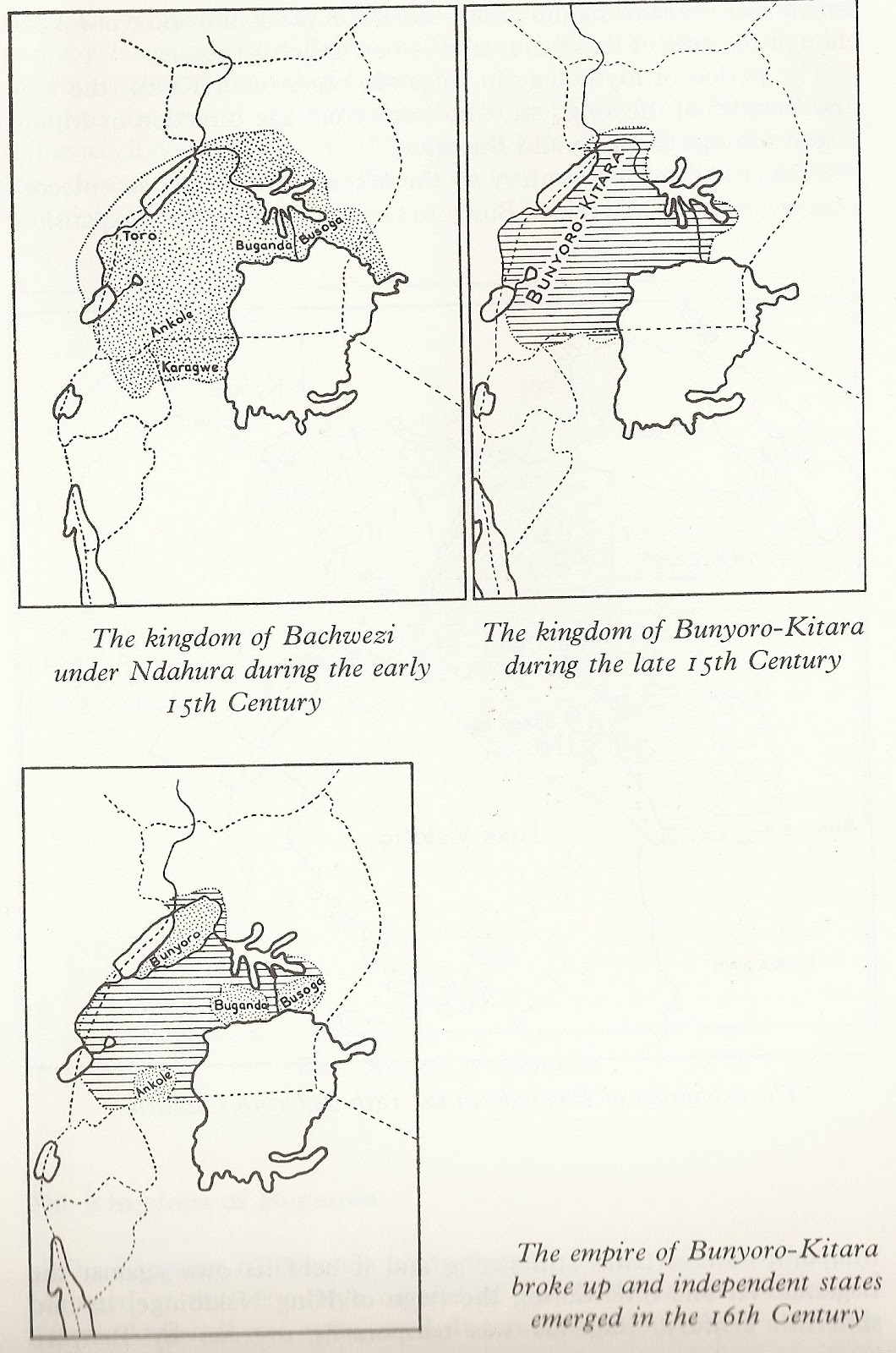
|
|
#
?
Dec 24, 2013 05:46
|
|

|
DrSunshine posted:EDIT: Hahaha. I'm Vietnamese American, and pretty much all three of the identified cities are located in/near counties with tons of Vietnamese people. That's fantastic. Well, I dunno about Fremont, but San Jose and Corona definitely. I know there're
|
|
#
?
Dec 24, 2013 05:54
|
|

|
 This one's politically-loaded because it makes me go on a rant about how Twin Peaks was too good for America.
|
|
#
?
Dec 24, 2013 06:30
|
|
|
Vivian Darkbloom posted:
I would love to visit the intersection of Big Love, South Park, Breaking Bad, and Medium. Maybe also The Office and The Wire.
|
|
#
?
Dec 24, 2013 06:40
|
|
|
Without knowing anything about The Virginian, I find it funny that it is in Wyoming. I can't imagine what would beat The Wire in this state.  It looks like DC isn't displayed. I vote Smart Guy.
|
|
#
?
Dec 24, 2013 06:42
|
|
|
GreenCard78 posted:
if Fringe had been set in Maryland I can guarantee it would be there instead of The Wire.
|
|
#
?
Dec 24, 2013 06:46
|
|

|
Civilized Fishbot posted:A map of America at the time of Northwestern's founding in 1851: I made this map. 
|
|
#
?
Dec 24, 2013 06:49
|
|


|
Civilized Fishbot posted:A relic "west" can also be found in Case Western University, shown below in this map of the top-ranked schools in the midwest. You've got the name slightly wrong. It's Case Western Reserve University. Back before the Revolution, most of the thirteen colonies had "sea-to-sea grants", basically meaning they claimed everything to the west until you hit seawater. Almost all of the colonies surrendered these grants to the federal government upon entering the union, in exchange for the federal government taking on their war debt, and were left generally with their current forms. The only ones who didn't were Georgia (its grant was truncated later), Virginia (which was far larger than it is now, but still surrendered Northwest Territory, which was part of its sea-to-sea grant [and overlapped with several other colonies' sea-to-sea greants]), and Connecticut. Connecticut's was interesting. They couldn't have a straight line, of course: Pennsylvania was in the way. This didn't stop them from continuing on the west side of Pennsylvania where they left off. And when they surrendered their grant to the federal government, they maintained one portion, which they called their "Western Reserve." This is now the northeast sixth or so of Ohio.
|
|
#
?
Dec 24, 2013 06:52
|
|
|
Vivian Darkbloom posted:
|
|
#
?
Dec 24, 2013 07:00
|
|
|
loving Army Wives jesus christ South Carolina is the rear end-end of everything.
|
|
#
?
Dec 24, 2013 07:07
|
|


|
Golbez posted:You've got the name slightly wrong. It's Case Western Reserve University. Back before the Revolution, most of the thirteen colonies had "sea-to-sea grants", basically meaning they claimed everything to the west until you hit seawater. Almost all of the colonies surrendered these grants to the federal government upon entering the union, in exchange for the federal government taking on their war debt, and were left generally with their current forms. The only ones who didn't were Georgia (its grant was truncated later), Virginia (which was far larger than it is now, but still surrendered Northwest Territory, which was part of its sea-to-sea grant [and overlapped with several other colonies' sea-to-sea greants]), and Connecticut. Wikipedia told me that my usage was an acceptable shortening  But this is history is really cool, thanks. But this is history is really cool, thanks. Golbez posted:I made this map. That's awesome! Thank you! I can see you've made a lot of maps - do you work in history/cartography or do you just enjoy being incredibly useful?
|
|
#
?
Dec 24, 2013 07:10
|
|
|
Gentlemen, welcome to California.    
|
|
#
?
Dec 24, 2013 07:33
|
|


|
I get results putting me in both California and the northeast, which makes sense. My father's from Connecticut and my mother's from Oakland, they both lived in the east for many years before moving to the East Bay where I grew up.
|
|
#
?
Dec 24, 2013 07:53
|
|


|
GreenCard78 posted:I can't imagine what would beat The Wire in this state. Maybe Homicide: Life on the Streets.
|
|
#
?
Dec 24, 2013 07:58
|
|
|
VitalSigns posted:Taking the piss? No way are you American withak posted:This is the devil beating his wife, right? I only know because I heard it in a song and was totally confused for a while. Interesting. Here in Holland I heard the phrase 'kermis in de hel' which means 'funfair in hell' for rain while the sun shines. I wonder if that's historically related to 'the devil beating his wife', and I wonder what it is called in other countries. Also, I speak Dutch, so I can read Afrikaans if I take my time, but I don't think I ever heard an Afrikaans song. The text was surprisingly understandable. As I understand it, the Afrikaners took Dutch a few hundred years ago, threw out all idiotic rules that makes my language so difficult to learn, changed a bunch of other things over time, and made the new language their own. Very interesting to compare the two languages. For instance, Afrikaans has the term 'aftrekplek' for a rest stop next to a large road. In Dutch 'aftrekplek' would mean a place for male masturbation. Signs like that are often photographed by Dutch tourists. Related: 
|
|
#
?
Dec 24, 2013 08:27
|
|

|
GreenCard78 posted:Without knowing anything about The Virginian, I find it funny that it is in Wyoming. He's from Virginia originally, so everyone calls him..wait for it...the Virginian.
|
|
#
?
Dec 24, 2013 08:28
|
|

|
Civilized Fishbot posted:Wikipedia told me that my usage was an acceptable shortening ") quote:That's awesome! Thank you! I can see you've made a lot of maps - do you work in history/cartography or do you just enjoy being incredibly useful? I've always kind of been obsessed with maps and cartography, though not by profession. Just decided one day that I liked the idea of a step-by-step map of a country, and went for it. And before that, decided that every province in the world needed a basic map on Wikipedia, so I went for that. Golbez fucked around with this message at 08:49 on Dec 24, 2013 |
|
#
?
Dec 24, 2013 08:37
|
|
|
Its funny, my first go through on that quiz gave me three Arizona cities but then western Washington appropriately looked just as red, but then a second go through without changing any of the questions I got again gave me Tacoma, Spokane and Salt Lake City. I actually do have family in Arizona but they moved THERE from here.
|
|
#
?
Dec 24, 2013 09:26
|
|
|
What the heck is "The Brotherhood of Poland, New Hampshire"? Nobody likes setting their shows in New Hampshire, I guess.
|
|
#
?
Dec 24, 2013 09:34
|
|
|
I assume West Wing would be the most popular show set in DC? Also, this thread and many, many others have thought me that Americans are obsessed with their accents. Especially in regards to soft drinks.
|
|
#
?
Dec 24, 2013 10:16
|
|
|
 It was rotaries that revealed my true colors here.
|
|
#
?
Dec 24, 2013 11:05
|
|

|
DarkCrawler posted:I assume West Wing would be the most popular show set in DC? X-Files maybe, if it counts. They went all over the place but Mulder and Scully were based in DC.
|
|
#
?
Dec 24, 2013 13:14
|
|


|
 Interesting how this also seems to track family history. From Houston, but mother's side of the family is from Louisiana (mostly Baton Rouge and New Orleans) and father's side is from southern Arkansas. I've never lived in Louisiana, only Houston, San Antonio and Austin. a bad enough dude fucked around with this message at 15:08 on Dec 24, 2013 |
|
#
?
Dec 24, 2013 15:04
|
|

|
Rincewind posted:
What's up same results buddy (grew up halfway between Boston and Worcester, lived in Providence for a while later on).
|
|
#
?
Dec 24, 2013 15:11
|
|

|
a bad enough dude posted:
Rincewind posted:
According to these maps, you two are enemies! 
|
|
#
?
Dec 24, 2013 15:40
|
|

|
What if you redrew the United States so state borders actually represented their constituents? You get something like this: Also cutting down to thirty-eight states means you can annex Canada and still get the even fifty (assuming you strip out PEI or one of the territories most likely).
|
|
#
?
Dec 24, 2013 16:55
|
|


|
A lot of these could probably use existing names, but renaming Hawaii without any change of territory stands out as especially pointless.
|
|
#
?
Dec 24, 2013 16:58
|
|

|
The divisions obviously aren't based on population since Texas is still mostly intact, and they obviously aren't based on culture either since the Valley is still part of Texas. It just seems like a bad map overall.
|
|
#
?
Dec 24, 2013 17:01
|
|
|
What's the point of Seward? A state with oil, polar bears, and 5 people doesn't really seem like a viable unit at all.
|
|
#
?
Dec 24, 2013 17:09
|
|


|

|
| # ? May 27, 2024 16:19 |
|
|
Apparently the map is from 1975 and was created by a CSULA professor whose primary criteria seems to have been trying not to cut up urban areas. I don't think it works that well, especially since it looks like my hometown's commuter area got sliced in two.
|
|
#
?
Dec 24, 2013 17:18
|
|