


|
Javid posted:
This is part of an animated map showing a reduction in air pollution from 2005 to 2011. 
|
 #
?
Jul 15, 2014 22:47
#
?
Jul 15, 2014 22:47
|
|


|

|
| # ? Jun 12, 2024 01:33 |
|
|
I'd love to see that if it included Canada. I'm sure our tar-sands are more than making up for your losses.
|
|
#
?
Jul 15, 2014 22:48
|
|


|
On that note I was wondering whether the new fracking operations in North Dakota and Montana were giving off new emissions.
|
|
#
?
Jul 15, 2014 22:49
|
|


|
Baronjutter posted:I'd love to see that if it included Canada. I'm sure our tar-sands are more than making up for your losses. They probably won't show up because most of the steam generation for the in situ processes comes from natural gas, which would have very low nitrogen dioxide emissions. As far as surface mining goes, I don't know but it is also unlikely because I doubt the extraction process (both mining and processing) is on the level of power plants, which are the biggest constituent of the map. Jerry Manderbilt posted:On that note I was wondering whether the new fracking operations in North Dakota and Montana were giving off new emissions. I also doubt they would show up because frac crews aren't single site emitters and move around a lot. There may be dozens of crews frackign on a single day, but they are spread out over a large area and idle almost half the time.
|
|
#
?
Jul 15, 2014 23:34
|
|


|
Pakled posted:This is part of an animated map showing a reduction in air pollution from 2005 to 2011. In units of "High" to "Low".
|
|
#
?
Jul 16, 2014 01:22
|
|

|
OctaviusBeaver posted:In units of "High" to "Low". It's not a great map, but it's from a fairly reputable source
|
|
#
?
Jul 16, 2014 02:15
|
|
|
It looks like we're making significant improvement, at least.
|
|
#
?
Jul 16, 2014 02:37
|
|

|
OctaviusBeaver posted:In units of "High" to "Low". It would be nicer if it was on the graph itself but it son the page it comes from. The range is 1 to 5 x 10^15 molecules/cm^2.
|
|
#
?
Jul 16, 2014 02:50
|
|

|
Why'd it get worse again? Is there a more recent one? someone posted this in a Civ thread and it seems appropriate here: submerged land for various amounts of sea level rise. a note from the bottom that is important and I bet lots of people will skip: quote:Some inland depressions, such as the Caspian Sea, show inundation on the map but would not be flooded. This is because the mapping algorithm is based upon elevation and can not distinguish areas that are separated from the oceans by a ridge or other high area. Be sure that you trace a connection with the ocean before assuming the area would be flooded.
|
|
#
?
Jul 16, 2014 02:51
|
|

|
Koramei posted:Why'd it get worse again? Is there a more recent one? Anyone know why there is no elevation data for the Narragansett Bay area? I remember when I was living in Providence 5 years ago, trying to make elevation charts of bike routes, only to run into the same problem.
|
|
#
?
Jul 16, 2014 03:30
|
|

|
SurgicalOntologist posted:Anyone know why there is no elevation data for the Narragansett Bay area? I remember when I was living in Providence 5 years ago, trying to make elevation charts of bike routes, only to run into the same problem. I'm pretty sure that whole area is �60m above the rest of New England.
|
|
#
?
Jul 16, 2014 03:46
|
|


|
Mister Adequate posted:This isn't because of maps, it's because we all learn countries from Paradox games, and no Paradox games have modern enough settings for decolonization to have taken place. Someone clearly hasn't played the leaked copy of East vs West. (Don't play the leaked copy of East vs West).
|
|
#
?
Jul 16, 2014 04:11
|
|


|
What's on the other side of the ocean?
|
|
#
?
Jul 16, 2014 04:53
|
|


|
At only 7m of sea level rise my apartment will be submerged but my office won't be so I'll have to live at work 
|
|
#
?
Jul 16, 2014 04:57
|
|


|
I very shamefully memorized my West African countries when I was teaching the map to Nigerian children in Nigeria.
|
|
#
?
Jul 16, 2014 05:25
|
|

|
Craptacular posted:What's on the other side of the ocean? Should be measured perpendicular to the shore.
|
|
#
?
Jul 16, 2014 05:41
|
|
|
Craptacular posted:What's on the other side of the ocean? It doesn't seem to count Madeira, The Canaries, or Cape Verde as the other side of the ocean.
|
|
#
?
Jul 16, 2014 06:45
|
|
|
Craptacular posted:What's on the other side of the ocean? I like how Chile and Argentina are their own buddies around Tierra del Fuego, with Chile even owning a couple of degrees all by itself.
|
|
#
?
Jul 16, 2014 07:51
|
|


|
Aliquid posted:I very shamefully memorized my West African countries when I was teaching the map to Nigerian children in Nigeria. Uggh that's hell of shameful.
|
|
#
?
Jul 16, 2014 07:55
|
|

|
This was just posted in Paradox thread 
|
|
#
?
Jul 16, 2014 08:22
|
|
|
I wanted to make a tribute to map projections that I like. I welcome any critiques. I'm not an expert, after all. I had some help from this.
|
|
#
?
Jul 16, 2014 08:57
|
|


|
Echo Chamber posted:I wanted to make a tribute to map projections that I like. Slow it down or make it into one big long image maybe? Right when I'm done reading and look up at the map it changes 
|
|
#
?
Jul 16, 2014 09:00
|
|
|
Echo Chamber posted:I wanted to make a tribute to map projections that I like. I like that Eckert III, doesn't seem too popular, not even really mentioned on Wikipedia even. Anyone know much about it that wants to write a blurb?
|
|
#
?
Jul 16, 2014 09:08
|
|
|
Craptacular posted:What's on the other side of the ocean?
|
|
#
?
Jul 16, 2014 09:13
|
|

|
Craptacular posted:What's on the other side of the ocean? Go east from the southernmost part of Canada and you reach Spain.
|
|
#
?
Jul 16, 2014 10:43
|
|


|
fermun posted:It doesn't seem to count Madeira, The Canaries, or Cape Verde as the other side of the ocean. Also the Falklands.
|
|
#
?
Jul 16, 2014 14:37
|
|
|
Craptacular posted:Also the Falklands. Las Malvinas son Argentinas etc.
|
|
#
?
Jul 16, 2014 14:45
|
|
|
The fuckers forgot about Sao Tome and Principe 
|
|
#
?
Jul 16, 2014 15:16
|
|

|
Those places aren't "other sidey" enough. Except Sao Tome I guess but then people would have to look up a place.
|
|
#
?
Jul 16, 2014 15:26
|
|

|
cheerfullydrab posted:You keep going east from Atlanta, you get to Baghdad. Just another pointless mapfact that honestly has surprised people I've met. The nearest US State to Africa is Maine. Buenos Aires is closer to New York than it is to Los Angeles. The Atlantic entrance to the Panama Canal is further west than the Pacific entrance. etc etc.
|
|
#
?
Jul 16, 2014 19:39
|
|

|
|
|
#
?
Jul 16, 2014 21:39
|
|

|
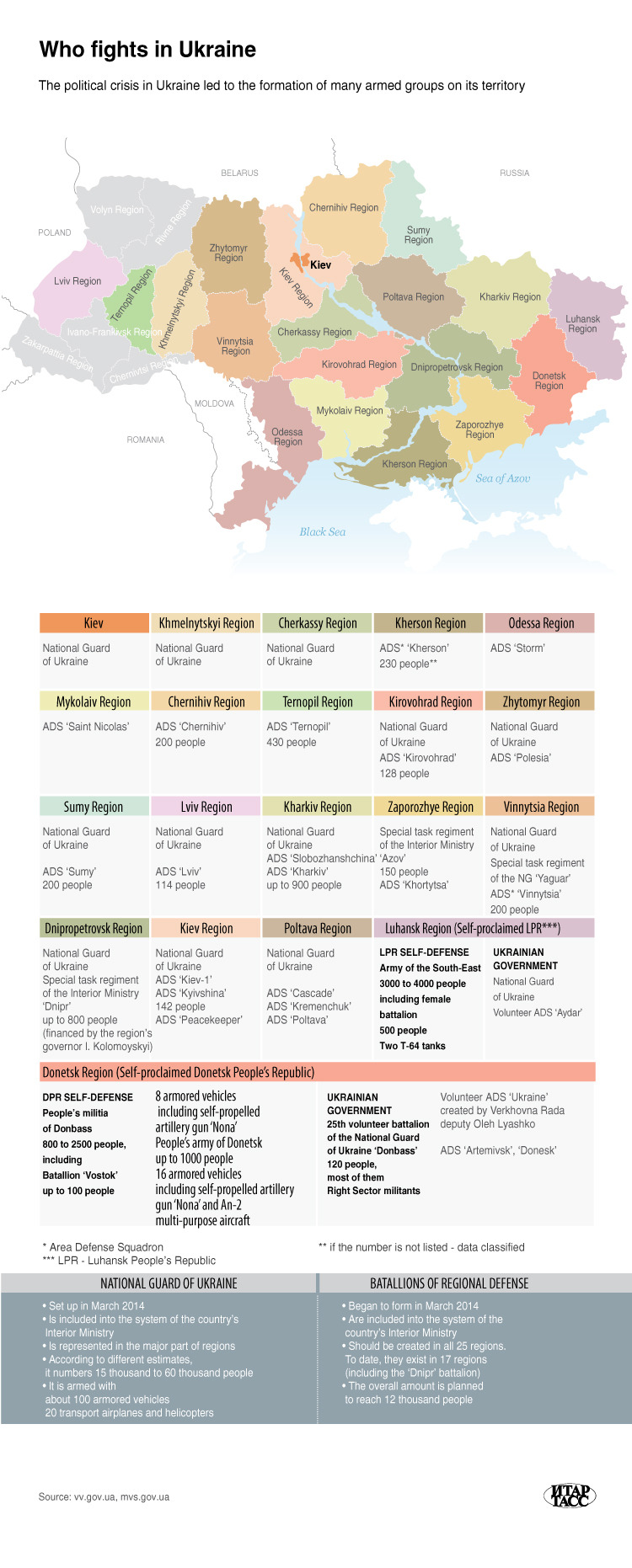
That map doesn't really live up to its title, since it doesn't actually include the Ukrainian Army. But well, live it up to ITAR-TASS to mention the National Guard as many times as possible.
|
|
#
?
Jul 16, 2014 22:49
|
|

|
fermun posted:I like that Eckert III, doesn't seem too popular, not even really mentioned on Wikipedia even. Anyone know much about it that wants to write a blurb? Eckert III and IV superficially look a little bit like the Ortelius Oval projection, but I personally don't like how the longitude lines in the middle meet up at one specific point in the pole line. It looks like two map projections stitched together. Echo Chamber fucked around with this message at 23:13 on Jul 16, 2014 |
|
#
?
Jul 16, 2014 23:09
|
|
|
Echo Chamber posted:I wanted to make a tribute to map projections that I like. Needs more Kavrayskiy VII.
|
|
#
?
Jul 16, 2014 23:18
|
|

 Yes, it's like a lava lamp.
|
Nothing against maps per se, but I had hoped that the "Hobo-Dyer" would be something far more exciting.
|
|
#
?
Jul 16, 2014 23:40
|
|

|
There is a pretty cool map of "unconventional" fracking since 2000 http://info.drillinginfo.com/unconventional-play-development-in-one-map/. I have huge reservations about this map because it doesn't include all fracs and counts things as unconventional (in this case I believe they intended to only show multiply fractured horizontal wells) that really aren't. There also really isn't any difference between fracking a vertical well compared to a horizontal one and I know that when West Texas lights up in 2004 (due to their data limitations) only a handful of wells were being drilled horizontally.
|
|
#
?
Jul 17, 2014 04:23
|
|
|
Map projection by David Dees?  
|
|
#
?
Jul 17, 2014 14:47
|
|


|
Disco Infiva posted:This was just posted in Paradox thread
|
|
#
?
Jul 17, 2014 21:17
|
|
|
Disco Infiva posted:This was just posted in Paradox thread I like how the map slowly fills in, and then BAM, 1250, Mongols.
|
|
#
?
Jul 17, 2014 23:45
|
|

|

|
| # ? Jun 12, 2024 01:33 |
|
|
drat this has become the imperialist colonialist thread.
|
|
#
?
Jul 18, 2014 02:16
|
|