


|
Saint Fu posted:I bought some Prana Zions and while they feel amazing, they're not breathable enough to keep my lower body cool while hiking. I'm sticking with shorts with long underwear available as an option for when it's cold. That's basically what I'm moving towards but I'm trying some wind pants too because long underwear doesn't do much for chilly evening winds by itself in my experience. If I was hiking in places where it was cool and through snow I probably would be looking for some breathable pants though
|
 #
?
Jul 14, 2014 19:25
#
?
Jul 14, 2014 19:25
|
|


|

|
| # ? May 23, 2024 01:32 |
|
|
What's that large, smooth looking green area that doesn't appear to be grass?
|
|
#
?
Jul 14, 2014 19:49
|
|

|
Ropes4u posted:I am searching for new hiking pants again. Can anyone comment on the quietness, durability, and quality of the Columbia and Prana convertible pants? I've always been partial to Bergans, http://shop.bergans.us/p/imingen-zip-off-pant?pp=24 . No idea if the brand is known in the US (going by their US store I'm guessing the USA isn't their biggest market heh) but their stuff is made for trekking here in Norway and I've yet to meet anyone who has been disappointed by their stuff.
|
|
#
?
Jul 14, 2014 20:16
|
|
|
Heners_UK posted:What's that large, smooth looking green area that doesn't appear to be grass? guessing grass seed?
|
|
#
?
Jul 14, 2014 22:39
|
|

|
MMD3 posted:We're heading to Jackson, WY the first week of August. Could anyone recommend some great hikes to do in/around the Tetons? I think we're looking for like 3-5 hour hikes rather than full-day outings. Surprise and Amphitheater Lakes is a great one. It's strenuous, 3000 feet of elevation gain in a little less than 5 miles, but it's worth it.
|
|
#
?
Jul 15, 2014 01:43
|
|

|
Ropes4u posted:I am searching for new hiking pants again. Can anyone comment on the quietness, durability, and quality of the Columbia and Prana convertible pants? Heners_UK posted:What's that large, smooth looking green area that doesn't appear to be grass?
|
|
#
?
Jul 15, 2014 02:59
|
|

|
My girlfriend moved to Bellingham. Are there any day hikes in the Lower Mainland worth doing if you have to cross the border to get there or should we just wait for the trails around Mt. Baker to melt out? It sounds like all the best stuff involves driving most of the way to Whistler, which is an ordeal if you have to drive all the way through Vancouver first.
|
|
#
?
Jul 15, 2014 03:14
|
|
|
Gorman Thomas posted:I did my first hike in new boots (danner crater rims) yesterday and only came away with one small blister so I'm pleasantly surprised. Did about 8 miles in Topanga at a good pace but the smog was pretty bad so we could barely see past Santa Monica. I hike in Topanga almost every weekend! I like to start at the south end of Temescal Ridge, go north to Eagle Rock, then turn west and hike to the Parker Mesa Overlook. Last time I was at the overlook, I got surrounded by fog coming off the ocean. It was pretty neat, even if I didn't get a view of the ocean and city.
|
|
#
?
Jul 15, 2014 03:45
|
|


|
lime rind posted:I have a pair of Columbia convertibles, but they're not the ones you linked. They only advertise Omni-wick instead of Omni-shade. They make a swishing noise, but it seems like a normal amount of noise. It's mostly in pants mode because the leg attachments flare out a bit. I've been happy with them, but they're also the only hiking pants I've owned so I don't have anything to compare them to. I haven't been rough with them, maybe sat on rocks/dirt at the most, and they haven't developed any holes and seems aren't falling apart. Columbus's are probably the best deal at sub $50, but I think I better go try them all on. If I was t planning on new packs and sleeping bags I wouldn't be so worried about the cash.
|
|
#
?
Jul 15, 2014 04:23
|
|

|
lavaca posted:My girlfriend moved to Bellingham. Are there any day hikes in the Lower Mainland worth doing if you have to cross the border to get there or should we just wait for the trails around Mt. Baker to melt out? It sounds like all the best stuff involves driving most of the way to Whistler, which is an ordeal if you have to drive all the way through Vancouver first. http://www.vancouvertrails.com/ has a nice list of ones around the lower mainland. Some of the hikes near Squamish might be doable for you in a day, though you'd want to set out early if you wanted to home at a reasonable time (plus the drive itself is long). Golden Ears might be reasonable to do and isn't as far from the border. Sumas or Elk Mountain are not as far from the border and would be doable in a day, even with the travel time.
|
|
#
?
Jul 15, 2014 21:47
|
|

|
Coolwhoami posted:http://www.vancouvertrails.com/ has a nice list of ones around the lower mainland. Some of the hikes near Squamish might be doable for you in a day, though you'd want to set out early if you wanted to home at a reasonable time (plus the drive itself is long). Golden Ears might be reasonable to do and isn't as far from the border. Sumas or Elk Mountain are not as far from the border and would be doable in a day, even with the travel time. Maybe a collection of sites like this is in order? In the SF Bay Area, I like to use quote:http://www.bahiker.com/ quote:http://www.redwoodhikes.com/
|
|
#
?
Jul 15, 2014 22:46
|
|
|
Elk Mountain is only about 60 miles from Bellingham, so it is likely I'll make it up there sooner or later this summer. Although I own a copy of 103 Hikes in Southwestern British Columbia, sometimes I feel like it's effectively 33 awesome hikes 150 miles from Vancouver and 70 hikes that require a 4WD vehicle and gain 600 meters in the first 2km of the route. Anyway, I think my baseline for Internet hiking guides is too high. Washington has http://www.wta.org/, which contains a massive volume of trail descriptions and trip reports for hikes across the state. Many of the trail descriptions come from hiking guides published by the Mountaineers, though you don't get the maps you'd get from buying the actual books. Even trails more than 100 miles from Seattle tend to get decent coverage. For the places the guide books don't cover, I like to check out http://www.nwhikers.net/. If you've ever wondered where a climbers path leads or what goes on beyond the "end maintained trail" signs at Mt. Rainier, they'll be happy to tell you.
|
|
#
?
Jul 16, 2014 03:16
|
|
|
Also for Golden Ears, I am dumb, do not try to do that unless you're leaving at 5 am from Bellingham. It is a very long tough hike that is tough for many coming right from the start in the morning.
|
|
#
?
Jul 16, 2014 03:34
|
|
|
lavaca posted:Elk Mountain is only about 60 miles from Bellingham, so it is likely I'll make it up there sooner or later this summer. Although I own a copy of 103 Hikes in Southwestern British Columbia, sometimes I feel like it's effectively 33 awesome hikes 150 miles from Vancouver and 70 hikes that require a 4WD vehicle and gain 600 meters in the first 2km of the route. A similar web hiking guide for the East Coast is http://www.hikingupward.com/, which covers Virginia, Maryland, and West Virginia. They're currently expanding their coverage into North Carolina and Pennsylvania as well. When most hiking websites look like they were put together in the late 90s having sortable trail lists and Google Map integration is a godsend.
|
|
#
?
Jul 16, 2014 03:37
|
|


|
So the province of British Columbia is sort of really on fire right now, and hiking conditions are pretty bad throughout the Canadian Rockies. I went on a road trip today to see what it was like.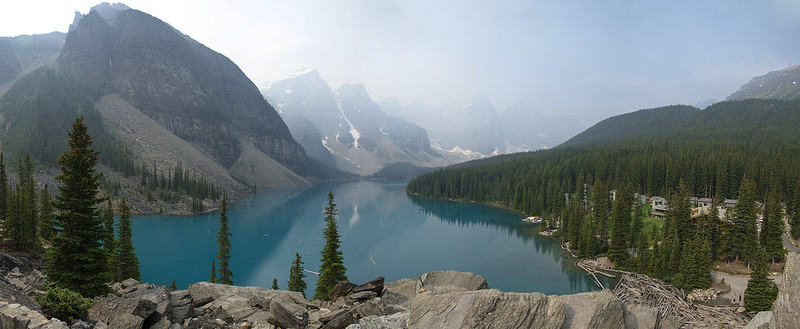 Panorama of Moraine Lake, smoky July. by Geographic Ecotourist, on Flickr It wasn't horrible at the beginning of the day, We could pretty much see all of the Valley of the Ten Peaks, even though it was quite hazy. Here are some comparisons, I'd never been to Two Jack Lake before so I had to steal that before pic off the internet.  Mt. Rundle in smoke by Geographic Ecotourist, on Flickr   Two Jack Lake, Missing Rundle by Geographic Ecotourist, on Flickr   The Three Sisters in smoke by Geographic Ecotourist, on Flickr 
|
|
#
?
Jul 19, 2014 03:09
|
|


|
Another birthday, another REI gift card. What're cool new toys to get that I don't need but I should want?
|
|
#
?
Jul 19, 2014 03:28
|
|

|
mastershakeman posted:Another birthday, another REI gift card. What're cool new toys to get that I don't need but I should want? Hahaha, you just perfectly summed up how i feel every time I get an REI gift card
|
|
#
?
Jul 19, 2014 03:41
|
|
|
Chopsticks!
|
|
#
?
Jul 19, 2014 04:16
|
|

|
Get some sort of camp furniture absurdity and then just use it in your back yard.
|
|
#
?
Jul 19, 2014 04:23
|
|
|
I just buy clothes. Socks. Button down shirts. I don't understand cotton clothes anymore.
|
|
#
?
Jul 19, 2014 04:25
|
|


|
JAY ZERO SUM GAME posted:I don't understand cotton clothes anymore.
|
|
#
?
Jul 19, 2014 14:25
|
|

|
Rei needs to carry merino dress socks :I
|
|
#
?
Jul 19, 2014 15:08
|
|
|
I totally spent my last $50 gift card on like 3 pairs of merino socks
|
|
#
?
Jul 19, 2014 17:15
|
|
|
Climbed up Mt. Rainier this past week. Fun time, though a lot of elevation gain (8,000 ft) from Paradise. There wasn't a cloud in the sky the entire week, so going up the Muir Snowfield was like trying to hike a snowcone. Wet, non-rigid slush for 6 hours and 4000'. Coming down wasn't much better, except you were on a much steeper slope. Hiking up to glacier camp:  Glacier Camp:  View from Camp Muir:  Picture from the summit: 
|
|
#
?
Jul 19, 2014 21:13
|
|

|
I was worried that the smoke from the fires in Oregon would be obscuring everything here, but the winds blew everything to the south so it made for a decent day. Along the way to the top, I passed hole in wall cliffs of no real significance  and almost had a nasty fall about this far from the top  It might have been from all the running I've done this week, but I've never felt so exhausted after a hike. It was only 10 miles roundtrip but the last 3-4 were painful and slow.
|
|
#
?
Jul 20, 2014 18:28
|
|


|
All the smoke from the fires seems to be coming to Glacier and I'm Pissed. I climbed Numa, kayaked a bit on Bowman lake and got hit by hurricane strength winds on the way to Mt Despair (the 80mph winds picked a 200+lb guy up and deposited him 10ft away, you couldn't stand or even crawl in this stuff) and I couldn't see poo poo even once through this smoke. Due to the wind, the smoke has cleared out a lot today and this wind is expected to calm tonight. Tomorrow I'm climbing Siyeh, then I'll hit three peaks in Southern Glacier on Wednesday, then I'll be heading to Wyoming to climb Gannett for a week.
|
|
#
?
Jul 20, 2014 22:16
|
|

|
What do you do that you apparently just get to backpack and climb nonstop?
|
|
#
?
Jul 20, 2014 22:21
|
|
|
2nd grade teacher & xc/track coach, summers are pretty open
|
|
#
?
Jul 20, 2014 23:12
|
|
|
I want to do the Timberline Trail around Mount Hood either in late August or early September. Anyone have any experience with it? Especially with the Elliot Creek Crossing? Full disclosure: I don't really have anyone to go with me so I'll probably be hiking it alone. Which sounds more and more appealing but also a little scary and dumb, considering some of the crossings and such. So, anyone know anything about it? (Yes, I was lazy and copy/pasted this from the local LAN thread. Sue me.) Part of what I'm looking for are good indicators of what kinds of temperatures and weather patterns I should prepare for. I've got probably 90% of the gear I need and have used all of it in the field, but I want to spend as much time with that last 10% as I can before I put this together. Obviously with elevation comes temperature changes and I should be prepared for rain, but I'm looking for specifics or things I might have missed in my initial assessment of what I'll need. The big things I know I still need to get are clothes for colder temperatures (I've been hiking and backpacking at elevations where this hasn't been an issue), possibly a backup GPS device, a solar charger, and some better rain gear than what I currently own. Everything else is just being sure I have enough food and being sure my body and mind are as prepared as possible. Footwear, tent, sleeping bag, cooking gear, etc are all in place and I feel good about them.
|
|
#
?
Jul 21, 2014 20:22
|
|

|
Anybody been up by Pasayten Wilderness lately? We're supposed to be flying out and doing a 6 day trip out by Jakita Ridge/Three fools peak in 2 weeks but I see the Carlton Complex fire is burning pretty good. With the trip still being 2 weeks out, I don't see this fire being out by then so I'm wondering if we should be looking at heading somewhere else, possibly further west. My main concern is that the NPs around (North Cascades, Olympic, Ranier) will be slammed with reservations and have limited to no space available for late/walk on reservations at this point. I guess I'll keep my eye on the fires and read up on the conditions. Even if the fires aren't in the immediate area I also don't want to be hiking in smoke all week long. That can't be good for eyes/lungs. Where we should be hiking is still 20-30 miles NW of the fires in their current state and winds blow West to East correct? Would smoke even be a problem?
|
|
#
?
Jul 21, 2014 21:24
|
|
|
I heard from someone in Colville that it was really smoky there for awhile but the winds have changed and most smoke is going to the southeast. Unless the fire gets a lot bigger you probably won't be hiking in any serious smoke but there will be haze that'll diminish views, especially to the east. There's also apparently a new fire on Middle Mountain but that looks well east of where you'll be and probably won't be big. You really can't do much but play it by ear I guess, it'll be easier to tell in a week.
|
|
#
?
Jul 21, 2014 22:18
|
|
|
That part of the Pasayten should be fine. You can always check out webcams on wsdot.was.gov and drivebc.ca to get a good idea as to the conditions in the area.
|
|
#
?
Jul 21, 2014 23:31
|
|
|
Geekboy posted:I want to do the Timberline Trail around Mount Hood either in late August or early September. Anyone have any experience with it? Especially with the Elliot Creek Crossing? I'm actually looking into doing the Timberline Trail this fall w/ my girlfriend. I'll happily share whatever I learn once I start doing my research in earnest. Sites like the http://www.nwhikers.net/forums/and http://www.portlandhikers.org/forum/ are probably the best places to go to ask about the conditions on the trail though.
|
|
#
?
Jul 22, 2014 00:09
|
|
|
I am looking to do some hiking in the Spanish Pyrenees in August. I am planning on doing some day trips and maybe one overnight/multi day hike. I have been looking at Ordesa and Monte Perdido National Park and Aig�estortes i Estany de Sant Maurici National Park to start and maybe some of the GR 11, but I was wondering if anyone had hiked in that area (or Catalonia in general) and had any tip, itineraries, or just general thoughts.
|
|
#
?
Jul 22, 2014 16:25
|
|
|
MMD3 posted:I'm actually looking into doing the Timberline Trail this fall w/ my girlfriend. I'll happily share whatever I learn once I start doing my research in earnest. Sites like the http://www.nwhikers.net/forums/and http://www.portlandhikers.org/forum/ are probably the best places to go to ask about the conditions on the trail though. Sweet. I've been reading Portland Hikers Field Guide, but I'll check the others out too. Geekboy fucked around with this message at 18:32 on Jul 22, 2014 |
|
#
?
Jul 22, 2014 18:07
|
|
|
Verman posted:Anybody been up by Pasayten Wilderness lately? The pasayten is pretty far away from the fires. It's raining here today as well so that should help.
|
|
#
?
Jul 22, 2014 19:49
|
|

|
I just spent 5 days around Jasper National Park in the Canadian Rockies doing some of the day hikes in the area, and holy gently caress was the smoke ever awful on Friday and early Saturday. Thankfully the wind cleared it out Sunday and it was good up till I left this morning. So I'm going to be doing a 5 day hike up Mount Robson in the BC part of the Rockies, and was wondering if there was anyone here who has done this hike before, and if so if there's any tips/general advice/nice dayhikes in the area. I've only ever done a serious backpacking trip twice (both were about 650m elevation gain over ~6 km), so even the bare basic poo poo would be appreciated.
|
|
#
?
Jul 23, 2014 08:50
|
|

|
Just got some new Leki poles, my old right one saved me in the wind at the cost of bending in the lower section. I was able to bend it back in a clamp but I was afraid it'd been compromised. O well, they were old as hell, and I can loan them to a pole-less friend when in need. These new ones are way lighter (but seem just as sturdy) and the forward angle on the grip is smaller: 8� as opposed to 15� on the old pair. Just curious, in the 10+ years since I got the other poles what made Leki decide to use a smaller angle?
|
|
#
?
Jul 25, 2014 01:57
|
|
|
Mederlock posted:I just spent 5 days around Jasper National Park in the Canadian Rockies doing some of the day hikes in the area, and holy gently caress was the smoke ever awful on Friday and early Saturday. Thankfully the wind cleared it out Sunday and it was good up till I left this morning. I'm going to assume you mean you're doing the 21km hike to Berg Lake, and not actually up Robson, since that's a conditioning mountain for Everest. ") First off, the first 8 km of the trail is a unique inland cedar rainforest created by the presence of Robson itself, you should appreciate how cool that is. First off, the first 8 km of the trail is a unique inland cedar rainforest created by the presence of Robson itself, you should appreciate how cool that is. No more biogeography nerd talk, I've been to Berg Lake twice, so I can help! I'll give you some pictures too. If you plan to split the distance into two days, stay at Whitehorn Campground as the half way point. Gorgeous views and a great water supply. It's popular though, but you can pre-book sites here https://secure.camis.com/Discovercamping/ If there's nothing available to reserve, head out early to try and beat others to the non-reserve sites.  Whitehorn campground, with a ranger station across the Robson River.  YOU HAVE TO REGISTER AT THE VISITOR'S CENTER AND WATCH A RETARDED MOVIE ABOUT HOW TO HIKE LIKE A SMART PERSON BEFORE THEY LET YOU GO ON THE TRAIL OVERNIGHT I am not joking. The earliest you can start is 8 a.m. when the visitor's center opens. They expect you to have a daily plan and use the sites you sign up for the nights you promised. Plan ahead. Keep your permit tag on your tent at all times. They don't gently caress around there. I swear this is the only trail in Canada where this happens. YOU HAVE TO REGISTER AT THE VISITOR'S CENTER AND WATCH A RETARDED MOVIE ABOUT HOW TO HIKE LIKE A SMART PERSON BEFORE THEY LET YOU GO ON THE TRAIL OVERNIGHT I am not joking. The earliest you can start is 8 a.m. when the visitor's center opens. They expect you to have a daily plan and use the sites you sign up for the nights you promised. Plan ahead. Keep your permit tag on your tent at all times. They don't gently caress around there. I swear this is the only trail in Canada where this happens.On the way to Berg Lake you HAVE TO stop at Emperor Falls. Do not miss it. I'm not kidding.  The trail is almost flat for the first 10km, then a ton of uphill, with the majority of the elevation gain being a 4 km stretch with no water sources. Pay attention to the signs and make sure you have water prepared before you start that section! It starts at the end of the Whitehorn camping area. From Berg Lake, I really love the Hargreaves Glacier day hike. You get really fantastic views of Berg and Mist Lake, their corresponding glaciers and Robson and the Helmet (smaller subsidiary peak right beside the main summit). I guess most people just climb up onto the lateral moraine, but I went all the way to the toe of the glacier and it was phenomenal. On the way back, don't go the way you came, take the Toboggan Falls trail. Toboggan Falls is a cascade waterfall on a 30 degree slope. It's crazy and fun to hop around on.      Another great day hike is Snowbird Pass, which I sadly didn't finish but got most of the way there. You hike up along the side of the Robson Glacier and up to the top of a ridge that overlooks a small icefield.  Robson Glacier on a brutally hot day. That trail is one of my top places on the planet. I would not be opposed to going there every year. There are a couple of other dayhikes from Berg Lake, but I haven't done them so I can't really form an opinion. And if you see the summit of Robson, consider yourself lucky. It's huge, towers a good 2000 feet above all of it's neighbours, and it usually has a cap of clouds on it because it creates its own weather. A family friend has been there 7 times and has never seen it. But in the 8 days I've spent in the area, I've seen the summit clear for 5. Because I am lucky. Definitely dress in layers and pack sleeping gear for cold, one day I was there it was over 25C full sun during the day then dropped down to near freezing at night. And don't be surprised if you spend the entire trip in full hot sun, or full cloud. I hiked out in clouds and rain my first time there. I actually really enjoyed it, but everyone else on the trail seemed miserable because you couldn't see poo poo.  Expect the unexpected and temperature extremes. Expect major thunderstorms out of nowhere. Expect to see, hear, and feel avalanches and serac collapses on the glaciers. The ground can shake several kilometers away, trust me, I've experienced it. Rumbling all the time. It's awesome. Robson is awesome. Long story short: EVERYONE hike the Berg Lake Trail. It may be a pain in the rear end, but it's worth it. 
|
|
#
?
Jul 25, 2014 10:05
|
|
|

|
| # ? May 23, 2024 01:32 |
|
|
And now I'm all pissed off because I broke my toe and am going to find it difficult to fulfill my backpacking plans for August. I booked the time off work and everything! 
|
|
#
?
Jul 25, 2014 10:15
|
|