


|
Torrannor posted:How can you have a writing system both right-to-left AND left-to-right? Are these Latin and Arabic alphabets used side by side in Malaysia? And why would that category not include Indonesia as well? Arabic script isn't really used in Indonesia, but it is in Malaysia. Technically any language can be written in the other direction, they just generally aren't. Used to be pretty common in China to have Right-to-Left and Left-to-Right until the PRC started enforcing standardization, you still see Right-to-Left sometimes in Japan but it's pretty rare.
|
 #
?
Aug 26, 2014 13:20
#
?
Aug 26, 2014 13:20
|
|

|

|
| # ? May 27, 2024 01:56 |
|
|
What's the random Latin blob in Russia, just north of Kazakhstan?
|
|
#
?
Aug 26, 2014 15:00
|
|


|
IceAgeComing posted:What's the random Latin blob in Russia, just north of Kazakhstan? I think it's Kazan, where Tatar is spoken (and written using the Latin alphabet) as well as Russian.
|
|
#
?
Aug 26, 2014 15:14
|
|

|
Torrannor posted:How can you have a writing system both right-to-left AND left-to-right?
|
|
#
?
Aug 26, 2014 15:16
|
|
|
Kegluneq posted:Perhaps it's a boustrophedonic script, changing direction at the end of each line?
|
|
#
?
Aug 26, 2014 15:20
|
|

|
3peat posted:Average transport prices in Europe I'm interested in how they calculate that, because I don't know any train service in the UK that you can travel sixty miles for a fiver.
|
|
#
?
Aug 26, 2014 15:24
|
|


|
3peat posted:What french regions will look like in the future EU Federation Brittany is reunified, a Good Map.
|
|
#
?
Aug 26, 2014 15:30
|
|


|
Kamrat posted:Southeast Asia sure has a lot of different scripts, feels like it's one for each country in certain regions and in some cases, several in the same country. The Brahmic scripts (basically everything in the two shades of orange in that map other than Ethiopic, the Canadian Aboriginal syllabics and Thaana) are exceedingly diverse. In India alone, you have something like ten distinct Brahmic scripts represented in the modern forms of the Eighth Schedule languages, and that's not even counting those that have fallen into disuse. On top of that, Tibetan, Sinhala, Burmese, Khmer, Thai and Lao each have their own distinct Brahmic derivative, and that's not even getting into scripts for minority languages (including like five other derivatives of the Thai script) or the (largely disused/historical) scripts of the Malay Archipelago.
|
|
#
?
Aug 26, 2014 15:43
|
|

|
Zhuyin isn't a writing system, it's a pronunciation guide like pinyin. And does Hokkaido only use katakana, or is the outlining just really thick?
|
|
#
?
Aug 26, 2014 16:20
|
|

|
House Louse posted:Zhuyin isn't a writing system, it's a pronunciation guide like pinyin. And does Hokkaido only use katakana, or is the outlining just really thick? No, they made it that way because I guess that's the primary area where most of the remaining Ainu are and the Ainu language is written only in katakana. But literally everybody except for 10 people in Hokkaido speak Japanese so it's not really correct. Yeah actually it's definitely a red circle and a red outline which ends up just looking like a totally red Hokkaido VVVV Modern Day Hercules fucked around with this message at 17:17 on Aug 26, 2014 |
|
#
?
Aug 26, 2014 16:53
|
|
|
House Louse posted:Zhuyin isn't a writing system, it's a pronunciation guide like pinyin. And does Hokkaido only use katakana, or is the outlining just really thick? I think there's a red circle (which ends up covering almost the whole island) on top of Hokkaido for the writing system of the Ainu language, which is katakana with some modified characters.
|
|
#
?
Aug 26, 2014 16:53
|
|
|
Badger of Basra posted:I'm sure the Basques and Catalans would love to join up with France, the only country with a worse attitude towards minority languages than Spain. Spain doesn't have a worse attitude towards minority languages than any other Western European country, they were just really bad at getting rid of them when everyone else was getting their nation-state on.
|
|
#
?
Aug 26, 2014 17:24
|
|


|
I had no idea the Ainu language was still about, thanks.
|
|
#
?
Aug 26, 2014 17:30
|
|
|
House Louse posted:I had no idea the Ainu language was still about, thanks. Oh, they're working on it, don't worry (actually it might have gotten better recently).
|
|
#
?
Aug 26, 2014 17:50
|
|
|
http://dotmap.adrianfrith.com/ http://adrianfrith.com/2013/09/12/comparing-2001-and-2011 Dot maps of ethnicity for South Africa. They really show the legacy of Apartheid-era urban planning, which segregated races into neat blocks. Or rather, segregated the "lesser" races into neat, cramped blocks while the rest was allowed to become white suburban sprawl. Probably the only encouraging thing about those maps is that when you zoom in to the vast sprawling white suburbs, you see a bunch of other-race dots.
|
|
#
?
Aug 26, 2014 18:05
|
|


|
Lead out in cuffs posted:http://dotmap.adrianfrith.com/ I love maps like this. There were some of US cities that were released before I was on these boards, but I'm sure you guys saw them.
|
|
#
?
Aug 26, 2014 21:09
|
|

|
Count Roland posted:I love maps like this. There were some of US cities that were released before I was on these boards, but I'm sure you guys saw them. That's one component of this set of interactive maps from the NY Times: http://projects.nytimes.com/census/2010/explorer it always starts centered over NYC, but you can search anywhere in the US.
|
|
#
?
Aug 26, 2014 21:19
|
|

|
Lead out in cuffs posted:http://dotmap.adrianfrith.com/ The white suburbs look less segregated than white suburbs of American cities.
|
|
#
?
Aug 26, 2014 21:35
|
|


|
Nintendo Kid posted:That's one component of this set of interactive maps from the NY Times: Thanks. Do maps like these exist for Canada? I'd like to see how a place like Toronto or Vancouver compares with US cities.
|
|
#
?
Aug 26, 2014 21:59
|
|
|
Torrannor posted:How can you have a writing system both right-to-left AND left-to-right? Are these Latin and Arabic alphabets used side by side in Malaysia? And why would that category not include Indonesia as well? I don't think any language does it anymore but to add to what others have said, ancient Greeks wrote boustrophedon, which was that they started a piece of writing left to right, changed right to left for the next line, back to left to right on line 3, right to left for line 4, etc. http://en.wikipedia.org/wiki/Boustrophedon This stopped about 500 BCE and everyone wrote boring left to right only. fermun fucked around with this message at 22:19 on Aug 26, 2014 |
|
#
?
Aug 26, 2014 22:17
|
|
|
Kamrat posted:Southeast Asia sure has a lot of different scripts, feels like it's one for each country in certain regions and in some cases, several in the same country. I'm betting the Americas would have looked like that as well, if millions of people hadn't been wiped out by European diseases  Sorry about the inaccurate Scandinavian name map, here's another dubious map: 
|
|
#
?
Aug 27, 2014 00:05
|
|

|
Thanks for all the nationalism book suggestions guys, I really appreciate it. I have a bunch of reading to do now. ")
|
|
#
?
Aug 27, 2014 00:06
|
|

|
ekuNNN posted:I'm betting the Americas would have looked like that as well, if millions of people hadn't been wiped out by European diseases Honestly, I'd doubt that. You'd probably see a single shared script rise up among the north american literate native populations, and either the same script or similar ones show up in south america.
|
|
#
?
Aug 27, 2014 00:17
|
|
|
Count Roland posted:Thanks. Do maps like these exist for Canada? I'd like to see how a place like Toronto or Vancouver compares with US cities. I did find one for Toronto: http://neoformix.com/Projects/DotMaps/TorontoVisMin.html It's kinda like a rainbow compared to South Africa or the US, especially when you zoom in close.
|
|
#
?
Aug 27, 2014 00:29
|
|
|
ekuNNN posted:Sorry about the inaccurate Scandinavian name map, here's another dubious map: Yes that map is indeed dubious. My county is named after a Native American tribe, but it's labeled as "abstraction". What??
|
|
#
?
Aug 27, 2014 00:29
|
|

|
Count Roland posted:Thanks. Do maps like these exist for Canada? I'd like to see how a place like Toronto or Vancouver compares with US cities. http://neoformix.com/Projects/DotMaps/TorontoVisMin.html E: drat it, beaten. And here's the dot maps for pretty much every major US city, if you don't feel like exploring yourself. (By why not, this is the maps thread, maps are fun.) https://www.flickr.com/photos/walkingsf/sets/72157626354149574 Sheng-ji Yang posted:The white suburbs look less segregated than white suburbs of American cities. 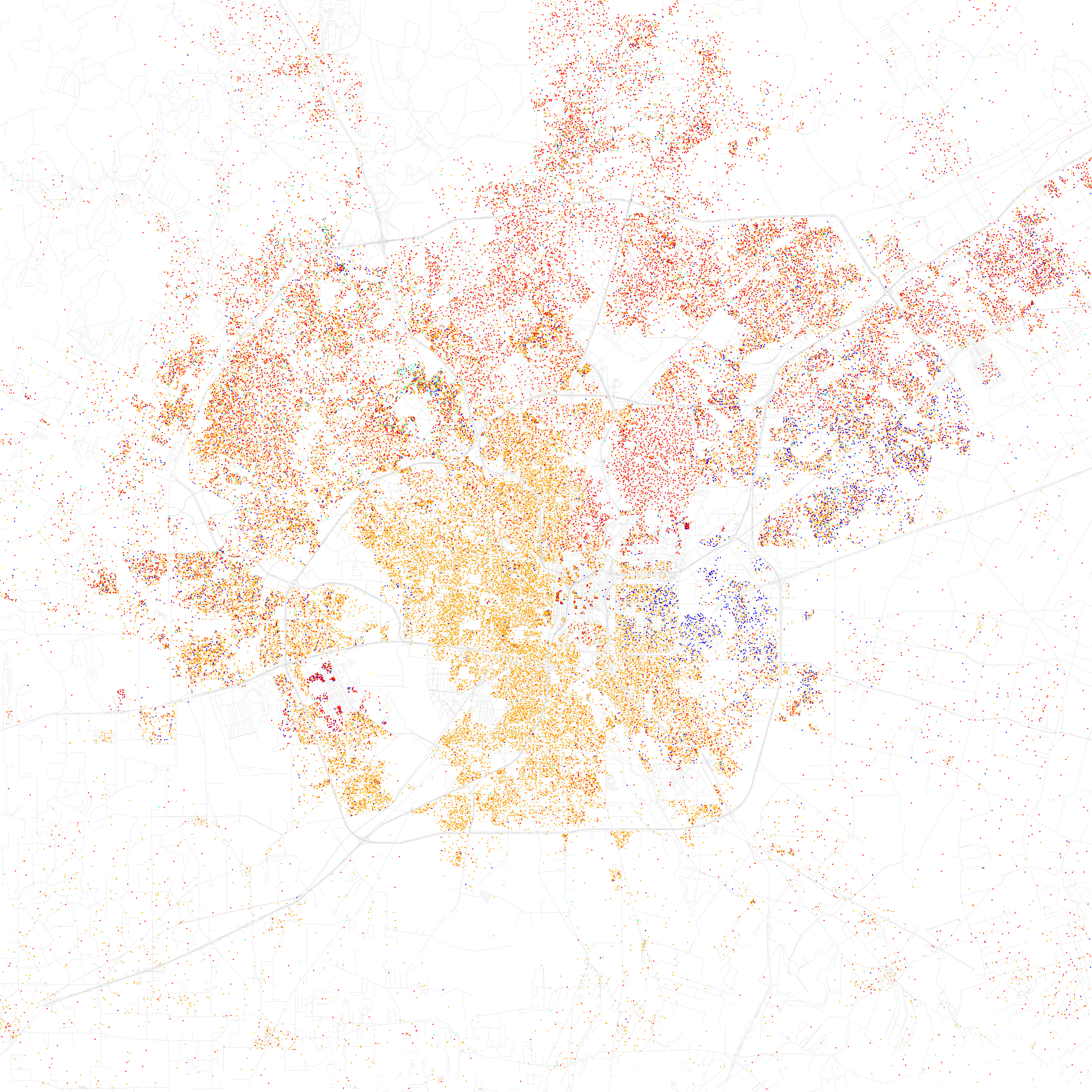 That would be my own hometown of San Antonio.  Legend: Red=White Blue=Black Orange=Hispanic Light Green=Asian Yellow=Other Even so, you can still see some of the general division lines; Whites live in the far north (there's a lot of new, recently built and really expensive housing up there) and in the northeast circle of Alamo Heights (well, most do, I'm a red dot in a majority Hispanic area with no plans to move, so take these generalizations with a grain of salt  ), Hispanics live in the center and south of the city, and Blacks live on the east side. That blob of color in the southwest is Lackland Air Force base, and the west side in general is rather integrated. ), Hispanics live in the center and south of the city, and Blacks live on the east side. That blob of color in the southwest is Lackland Air Force base, and the west side in general is rather integrated.Still, San Antonio is a bastion of integration compared to places like Chicago, Detroit, New Orleans, Washington, DC, Baltimore, Cleveland, and even a lot of parts of New York City. 
fade5 fucked around with this message at 01:12 on Aug 27, 2014 |
|
#
?
Aug 27, 2014 00:40
|
|
|
It's almost like sometimes etymologies get conflagrated and twisted by tales so people don't know which is real.
|
|
#
?
Aug 27, 2014 00:42
|
|

|
Ditocoaf posted:Yes that map is indeed dubious. My county is named after a Native American tribe, but it's labeled as "abstraction". What?? In Michigan, a lot of the 'abstractions' are due to the white guy in charge of Native American affairs making up a bunch of native american sounding words that really weren't based off of anything, for county names. However, marking Washtenaw as a body of water, when the word means any far off water, is a little weird.
|
|
#
?
Aug 27, 2014 02:35
|
|

|
If you want to see a sharply segregated city, look at Austin, TX. If you only hang out around the "weird" parts, you'd think the town was 90% white.
|
|
#
?
Aug 27, 2014 03:32
|
|
|
ClearAirTurbulence posted:If you want to see a sharply segregated city, look at Austin, TX. If you only hang out around the "weird" parts, you'd think the town was 90% white. Austin is the most segregated city in Texas but it's still not much compared to the rustbelt.
|
|
#
?
Aug 27, 2014 04:06
|
|
|
ClearAirTurbulence posted:If you want to see a sharply segregated city, look at Austin, TX. If you only hang out around the "weird" parts, you'd think the town was 90% white. Chicago and Milwaukee are both significantly worse, although Austin is rapidly trying to catch up.
|
|
#
?
Aug 27, 2014 04:26
|
|

|
ekuNNN posted:I'm betting the Americas would have looked like that as well, if millions of people hadn't been wiped out by European diseases How is Worcester County, MA labeled as "local landscape" and not foreign place
|
|
#
?
Aug 27, 2014 04:38
|
|

|
Ferroque posted:How is Worcester County, MA labeled as "local landscape" and not foreign place I'm guessing that when a county is named after a local city, they go with "local landscape, etc." even if the city was named after a foreign place.
|
|
#
?
Aug 27, 2014 04:53
|
|
|
Lycus posted:I'm guessing that when a county is named after a local city, they go with "local landscape, etc." even if the city was named after a foreign place. Lancaster County got foreign place even though I'm pretty sure Lancaster city was there first. The map seems pretty off for some.
|
|
#
?
Aug 27, 2014 04:56
|
|
|
Lycus posted:I'm guessing that when a county is named after a local city, they go with "local landscape, etc." even if the city was named after a foreign place. They definitely do that because in California, all of the Santa or San counties should be "religious leader or abstraction," but they're labeled as being named after the cities instead.
|
|
#
?
Aug 27, 2014 05:03
|
|


|
Plinkey posted:Lancaster County got foreign place even though I'm pretty sure Lancaster city was there first. The map seems pretty off for some. That comes because being named after Lancaster takes priority. Even if you pronounce it wrong.
|
|
#
?
Aug 27, 2014 08:43
|
|
|

|
|
#
?
Aug 27, 2014 10:39
|
|

|
ekuNNN posted:I'm betting the Americas would have looked like that as well, if millions of people hadn't been wiped out by European diseases How many writing systems did America have before the Europeans arrived? I know the Maya had one but the Inuit/Yupik/Cherokee didn't get theirs until 19th century so theirs doesn't count.
|
|
#
?
Aug 27, 2014 13:39
|
|

|
I think the Maya were the only ones with what could indisputably be called a written language, but there were a lot of proto-writing systems around and ways of recording information that aren't writing per se, like wampum or quipu.
|
|
#
?
Aug 27, 2014 14:07
|
|

|

|
| # ? May 27, 2024 01:56 |
|
|
made of bees posted:I think the Maya were the only ones with what could indisputably be called a written language, but there were a lot of proto-writing systems around and ways of recording information that aren't writing per se, like wampum or quipu. At least two of the earlier cultures in Mesoamerica produced what strongly appear to be written scripts (they even look rather like Mayan), but my understanding is we haven't exactly deciphered them yet. The Aztecs (and Mixtecs, and probably some other cultures in that area of Mexico as well) had what is either a heavily pictorial writing system or a quite robust form of proto-writing. Incidentally, if the hypothesis that Brahmi is descended from a Semitic script is true, then almost every major modern writing system except for Chinese (and the obviously Chinese-derived Japanese) ultimately derives from the Phoenician alphabet or similar.
|
|
#
?
Aug 27, 2014 15:21
|
|