|
bongwizzard posted:Hiking is literally just putting on some shoes and walking. I guess you could skip the shoes if you're a hippy or something. Hey you better show more respect, did you see the stats that guy had at the end of his post? Sounds like we've got a big league hiker posting up in here.
|
 #
?
Jan 11, 2017 18:52
#
?
Jan 11, 2017 18:52
|
|


|

|
| # ? Jun 4, 2024 00:05 |
|
|
 I just thought of a good reason that everyone needs two trekking poles. I just thought of a good reason that everyone needs two trekking poles.Anyway, I'll see y'all in the news and SAR reports. https://www.ncbi.nlm.nih.gov/pubmed/19737043 And I'll just leave this here so you don't have to deal with paragraphs in the thread. http://www.kcsara.org/media/press_kit#safety_information
|
|
#
?
Jan 12, 2017 00:53
|
|

|
Yes, but how many deaths were attributed to trail runners?
|
|
#
?
Jan 12, 2017 05:26
|
|


|
On my AT thru hike this year I'm just going to take it really easy and go about 5 miles a day the first week. I really don't wanna injure myself.
|
|
#
?
Jan 12, 2017 09:23
|
|

|
Internet Explorer posted:Yes, but how many deaths were attributed to trail runners? The ones carrying guns?
|
|
#
?
Jan 12, 2017 13:01
|
|

|
How many self-impaled on ice axes due to distractions by their hiking party? 
|
|
#
?
Jan 13, 2017 00:24
|
|
|
PhantomOfTheCopier posted:How many self-impaled on ice axes due to distractions by their hiking party? It happened to that scrub George Mallory so it could happen to anyone.
|
|
#
?
Jan 13, 2017 04:41
|
|
|
I've been fully embracing my new year's resolution of getting outside and taking advantage of living in Colorado. Went for my first legit hike today. 1200 feet elevation gain in 1.7 miles, and it kicked my rear end. I now have mucho respect for those people who can bag peaks like it ain't no thing. Hopefully as my conditioning improves and the weight drops off, these hikes will become easier. 
|
|
#
?
Jan 15, 2017 01:43
|
|
|
Hughmoris posted:I've been fully embracing my new year's resolution of getting outside and taking advantage of living in Colorado. Good on you. My wife and I moved from Florida to Colorado and it took us a while where a hike like that wouldn't kick our butts. We're not Uber hikers by any means, but it gets better pretty quickly.
|
|
#
?
Jan 15, 2017 07:20
|
|
|
I decided to aim for completing the 52 Hike Challenge this year. So far we've done 3: Monrovia Canyon, Ryan Mountain in Joshua Tree, and Sandstone Peak down in Malibu. I don't always like living in Southern California, but we do have some good options for getting on trails. Thanks to those of you who post photos from SoCal hikes--it's good motivation.
|
|
#
?
Jan 15, 2017 18:02
|
|

|
Saw my first armadillo in the woods yesterday, they look much cuter when not squished on the highway.
|
|
#
?
Jan 15, 2017 18:12
|
|

|
erobadapazzi posted:I decided to aim for completing the 52 Hike Challenge this year. So far we've done 3: Monrovia Canyon, Ryan Mountain in Joshua Tree, and Sandstone Peak down in Malibu. I don't always like living in Southern California, but we do have some good options for getting on trails. Thanks to those of you who post photos from SoCal hikes--it's good motivation. If you feel like travelling a bit the Cleveland National Forest has some pretty neat trails. It's also broken up into three areas so you don't have to always travel down to the Descanso Ranger District to do stuff.
|
|
#
?
Jan 15, 2017 19:13
|
|


|
Heading out tomorrow for a 20 day mountaineering course in the Andes, hopefully I won't die and will have some kickass pictures to share afterwards!
|
|
#
?
Jan 17, 2017 03:03
|
|

|
Sounds excellent, have fun!
|
|
#
?
Jan 17, 2017 14:15
|
|
|
Can anyone recommend any good 3-5 day loops in Zion or Moab? We would like to link up some Utah hiking and biking this summer.
|
|
#
?
Jan 18, 2017 04:05
|
|

|
Checked out the Santa Margarita River Trail in Fallbrook, CA on Monday. Back in 2007 the Rice Canyon Fire reached back in this area but it's recovered nicely since then.     
|
|
#
?
Jan 18, 2017 19:10
|
|
|
Just set a PR for distance hiked: 6.0 miles. My previous best was 3.4 . I'm still sucking wind when gaining elevation but I think my conditioning is improving little by little. I really want to summit a Colorado 14'er this summer, even if it's the easiest one that I can just walk up.
|
|
#
?
Jan 20, 2017 23:30
|
|
|
We have a warm front moving through right now and my mind can't stop saying "we should go hiking this weekend!". No, brain, there is 700cm of snow on the mountains, it'll be a few months. 
|
|
#
?
Jan 20, 2017 23:35
|
|

|
Rime posted:We have a warm front moving through right now and my mind can't stop saying "we should go hiking this weekend!". I feel you. All the snow is melting where I am in the southern Okanagan(not on top of the mountains of course), and I have ants in my pants.
|
|
#
?
Jan 20, 2017 23:55
|
|
|
Hughmoris posted:Just set a PR for distance hiked: 6.0 miles. My previous best was 3.4 . I'm still sucking wind when gaining elevation but I think my conditioning is improving little by little. Keep us updated on the progress.
|
|
#
?
Jan 21, 2017 00:50
|
|
|
PhantomOfTheCopier posted:Awesome job! Remember to give your body time to recover, and stretch and stuff so you don't pull something. Thanks. I spent my entire first year in Colorado being a homebody, so I have some ground to make up. Plus it's helping me shed weight. Today I was planning on doing a light hike to get me outside near Golden, CO. The park brochure said 2.2 miles roundtrip. Turns out they are full of poo poo. Ended up taking 2 hours through packed snow hills, and reviews on Alltrails say it's basically 4.4 miles. The views were well worth it.  
|
|
#
?
Jan 22, 2017 00:47
|
|
|
A perfect weather forecast on Friday, and the need to distract myself from the inauguration prompted me to take a vacation day and get to the mountains. I've been working on the winter New Hampshire 4000 footers for the last few years, and want to finish this year. I managed to cross Washington, Monroe, and Jefferson off the list with a 12.5 mile hike with about 5100' of elevation gain. Now I just need Zealand and West Bond (a 23 mile day!). The weather was absolutely perfect. It was sunny with clear skies, and an undercast down in the valleys. Visibility was great, I could see Mount Mansfield, Camel's Hump, and Ellen and Abraham in Vermont. Temps were in the low 30s, and there was only a light breeze on the summits. The average wind speed for Mount Washington in January is 46 mph. Conditions were mixed, I used every form of traction I brought, microspikes, snowshoes, and crampons. Full Album Strava Link 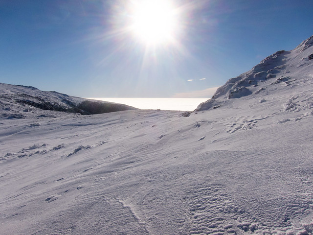 Monroe-Washington Col by EPICAC, on Flickr 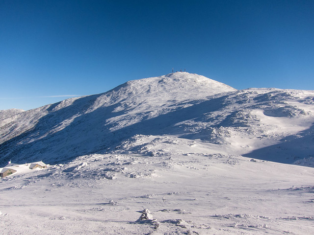 Washington from Monroe by EPICAC, on Flickr 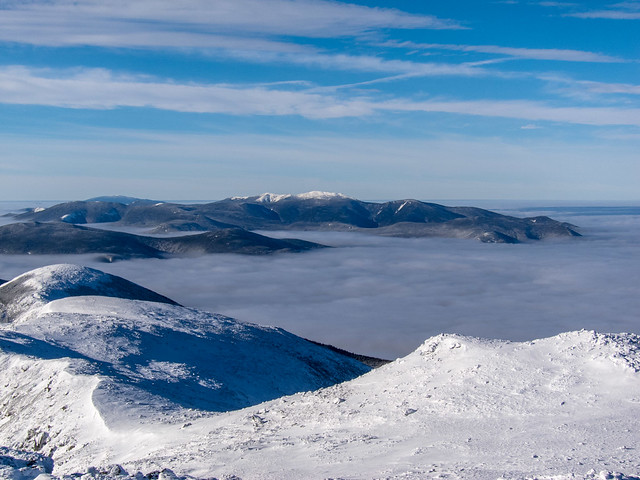 Francoia Ridge in the Distance by EPICAC, on Flickr 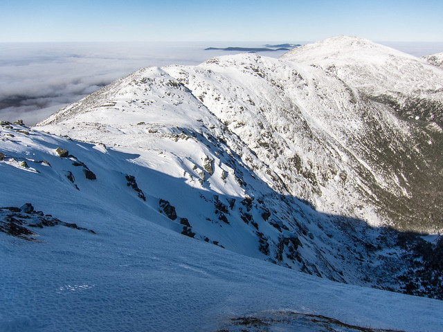 The Great Gulf by EPICAC, on Flickr 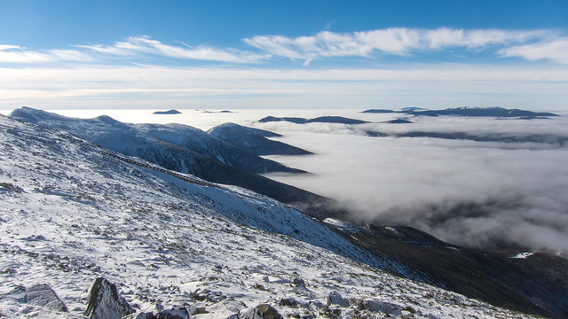 Ridges and Undercast by EPICAC, on Flickr 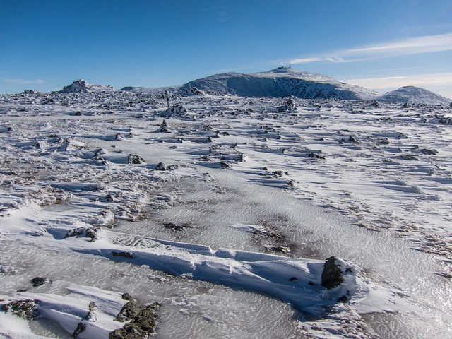 Monticello Lawn by EPICAC, on Flickr 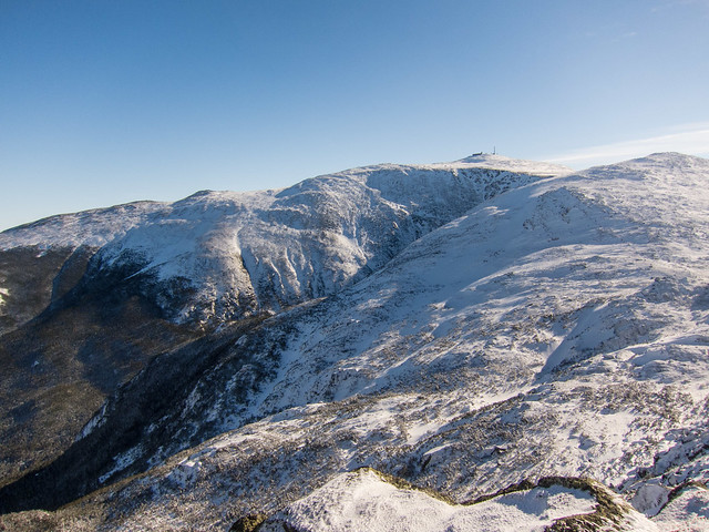 Mount Washington by EPIAC, on Flickr
|
|
#
?
Jan 22, 2017 00:58
|
|


|
EPICAC posted:A perfect weather forecast on Friday, and the need to distract myself from the inauguration prompted me to take a vacation day and get to the mountains. I've been working on the winter New Hampshire 4000 footers for the last few years, and want to finish this year. I managed to cross Washington, Monroe, and Jefferson off the list with a 12.5 mile hike with about 5100' of elevation gain. Now I just need Zealand and West Bond (a 23 mile day!). Awesome pictures! Were you the only one up there?
|
|
#
?
Jan 22, 2017 01:32
|
|
|
Hughmoris posted:Awesome pictures! Were you the only one up there? I think the weather was too nice to have the mountains to myself. I saw about a dozen other people, but the lot was full when I got back to my car. I hiked the first hour with a woman who left the parking lot when I did, and ended up hiking the ridge from the summit of Monroe to Jefferson with a another guy and his dog.
|
|
#
?
Jan 22, 2017 02:37
|
|
|
What (if any) type of smart devices do you hike with? I currently just have an Android phone but I'd like to start logging my hiking routes, distances etc... Being new to the scene, I really don't know what type of features work well for hiking.
|
|
#
?
Jan 22, 2017 03:11
|
|
|
Hughmoris posted:What (if any) type of smart devices do you hike with? I currently just have an Android phone but I'd like to start logging my hiking routes, distances etc... Being new to the scene, I really don't know what type of features work well for hiking. I just use my phone. I've used an iPhone, but now I have a Moto X Pure, and I use an app called Endomondo which has a nice web interface and a decent app. It allows you to track hiking, running, biking...kayaking. Almost everything you can imagine. If I am backpacking I might bring a battery pack with me so that I can charge my phone, but if you just turn Endomondo on and don't use anything else, and turn it off when you stop, it should last you a couple days, depending how long you're hiking for. You can use a blue-tooth heart rate monitor if you're interested in that kind of thing. I've used a cheap one I bought on amazon with the app and phone, but usually just for running. Here is an example of the web interface:  Lots of data to dig into for multiple workouts, for weeks, months, years, etc etc. The android app is quite good as well. It's free, but there is a premium version that allows you to compare your data with other people, broken down by gender and age-group and so on. There might be other premium features, I can't remember off-hand. It's $20/year. edit: Here's an example of some aggregate data for the last year: 
Tsyni fucked around with this message at 04:23 on Jan 22, 2017 |
|
#
?
Jan 22, 2017 04:18
|
|
|
Hughmoris posted:Awesome pictures! Were you the only one up there? EPICAC posted:I think the weather was too nice to have the mountains to myself. I saw about a dozen other people, but the lot was full when I got back to my car. I hiked the first hour with a woman who left the parking lot when I did, and ended up hiking the ridge from the summit of Monroe to Jefferson with a another guy and his dog. you never have a trail to yourself in the whites ... because ed hawkins was at the trailhead before you got out of bed
|
|
#
?
Jan 22, 2017 04:26
|
|
|
Tsyni posted:I just use my phone. I've used an iPhone, but now I have a Moto X Pure, and I use an app called Endomondo which has a nice web interface and a decent app. It allows you to track hiking, running, biking...kayaking. Almost everything you can imagine. If I am backpacking I might bring a battery pack with me so that I can charge my phone, but if you just turn Endomondo on and don't use anything else, and turn it off when you stop, it should last you a couple days, depending how long you're hiking for. This looks like exactly what I'm wanting. I'll check it out, thanks!
|
|
#
?
Jan 22, 2017 04:57
|
|
|
Hughmoris posted:What (if any) type of smart devices do you hike with? I currently just have an Android phone but I'd like to start logging my hiking routes, distances etc... Being new to the scene, I really don't know what type of features work well for hiking. I used to use an app on my iPhone with downloadable topo maps for the lower 48, but they stopped supporting it. I liked the ability to see your position on the map. Currently I use a Garmin 230, which I primarily have for running. It doesn't have maps functionality, but I have the "Other" activity set up for hiking the first screen has distance, time, and current elevation fields. The second screen has lap distance, lap time and current elevation fields. I hit the lap button at every trail junction. Combined with study of a map before a hike, and consultation during, it's usually enough to roughly place myself. I have my Garmin Connect account synced with Strava, which is what I use to keep track of my runs/hikes/etc. 
|
|
#
?
Jan 22, 2017 19:54
|
|
|
.
|
|
#
?
Jan 22, 2017 22:36
|
|


|
I just use Runkeeper on my phone. Works well enough, can accept various heart rate monitors, and is free.
|
|
#
?
Jan 23, 2017 01:28
|
|

|
I use gaia if I'm off trail and want to be able to figure out afterwards exactly where I was and where a picture was taken. It eats battery though. You can download topo maps and use it with tracking turned off which can be really helpful.
|
|
#
?
Jan 23, 2017 03:39
|
|
|
Over the last half of May (I mentioned this before in the thread) we are driving from Knoxville, TN to Grand Canyon (2 to 3 days there) to Las Vegas, NV, and then we are heading back thru Utah and Colorado. We will have around 7 days in those two states. We will be camping for most of the trip (outside of a night at my brothers, we might only stay in a hotel 3 to 4 nights the whole trip). As I said before on here we plan to camp some out of our Outback (we are doing a test run in March), but I have great tents and sleeping gear that we will mainly use. Also we are hikers, but all of our hiking is of course in the Appalachians. We are ok hikers (we did over 100 miles just in the GSMNP for 2016), but the most we have climbed in a single hike is 3,500 to 4,000 feet. Also out highest summits are of course in the 6,500 to 6,600 range given the area we live. So any advice on the following would be appreciated: - Any day hikes in the Grand Canyon that are moderate (even hard we do as long as they are not extreme) that gives a one of kind of experience that the Grand Canyon can offer? - What are must places to go in Utah? So far with have a list of possible places like Zion, Grand Staircase, Canyonlands, Monument Valley, and Arches. Any must hikes? The Firey Furnace is the only one our list so far. - In Colorado to get the Rocky Mountain experience do you have to go to Rocky Mountain National Park? Places like White River and Arapaho look like (well at least on Google) they could give the same experience. - Any campground recommendations, off beaten places to see (we are pretty taking I-40 out, but on the way back we are open as long as it follows our way back across Utah and Colorado), anybody else done a trip like this? Thanks. Edit: Electoral Surgery posted:I use gaia if I'm off trail and want to be able to figure out afterwards exactly where I was and where a picture was taken. It eats battery though. You can download topo maps and use it with tracking turned off which can be really helpful. Does it show your route once done and it does it work if I put my iPhone in airplane mode? nate fisher fucked around with this message at 16:31 on Jan 23, 2017 |
|
#
?
Jan 23, 2017 16:28
|
|

|
nate fisher posted:Over the last half of May (I mentioned this before in the thread) we are driving from Knoxville, TN to Grand Canyon (2 to 3 days there) to Las Vegas, NV, and then we are heading back thru Utah and Colorado. We will have around 7 days in those two states. My girlfriend and I did a trip to Utah this past October. Zion is cool and the Narrows is fun, but it may not be open yet due to the snowmelt. If you're backpacking, head to Canyonlands and try to get a backcountry site in the Chesler Park area. It's gorgeous, and the Joint Trail was one of my favorite parts of the trip. Even if you're not camping out there, you can still do the trail as a day hike, I think it's about 10 miles round trip. Backcountry camping is not allowed in Arches at the moment, and their campground is closed, but there's plenty of BLM sites around Moab. Otherwise you're stuck at one of the places that charges $40 to pitch a tent in a parking lot. Enjoy the trip! We loved every minute of it.
|
|
#
?
Jan 23, 2017 17:23
|
|


|
nate fisher posted:Does it show your route once done and it does it work if I put my iPhone in airplane mode? Yes it shows your route and you can overlay several routes onto the map at once. In airplane mode it lets you look at saved map/topo data but I don't know if the GPS functionality works. I would assume not?
|
|
#
?
Jan 23, 2017 19:42
|
|
|
Sounds like it depends on device. There are usually workarounds to get GPS working if you need it. http://backcountrynavigator.com/using-android-gps-airplane-mode/
|
|
#
?
Jan 23, 2017 19:47
|
|
|
nate fisher posted:What are must places to go in Utah? So far with have a list of possible places like Zion, Grand Staircase, Canyonlands, Monument Valley, and Arches. Any must hikes? Angels Landing in Zion is pretty much the most beautiful and rewarding hike I have ever done. It was a bitch for me because I'm out of shape and have bad knees, but the view from the top was totally amazing. Not good if you are afraid of heights.
|
|
#
?
Jan 24, 2017 00:06
|
|


|
marshmonkey posted:Angels Landing in Zion is pretty much the most beautiful and rewarding hike I have ever done. It was a bitch for me because I'm out of shape and have bad knees, but the view from the top was totally amazing. Not good if you are afraid of heights. And it's a short hike, so it won't kill your day. Bryce Canyon is worth a visit if you're in that neighborhood I think. The view from the rim is amazing, and there are some neat loop hikes that don't have a ton of elevation change.
|
|
#
?
Jan 24, 2017 01:22
|
|

|
Camping out of your Outback? Rock on! We got ours last May and we've done road trips as far afield as Colorado and Georgia in it already. That car is just such a dream to drive and camp in.
|
|
#
?
Jan 24, 2017 01:30
|
|
|

|
| # ? Jun 4, 2024 00:05 |
|
|
nate fisher posted:- What are must places to go in Utah? So far with have a list of possible places like Zion, Grand Staircase, Canyonlands, Monument Valley, and Arches. Any must hikes? The Firey Furnace is the only one our list so far. Observation Point was my favorite hike in Zion! Absolutely stunning views at end, well worth it if you're looking for a day hike. If you're able to stop in Bryce, the Navajo/Queens garden loop is awesome, the Wall Street area is gorgeous... Oh yeah, do a sunrise hike at Mesa arch in Canyonlands, one of my very favorite moments from our trip in October! The entire arch glows various shades of orange and yellow, photographers heaven. I just realized that your username is my avatar, six feet under still remains one of my favorite shows of all time... Have an amazing trip. ")
|
|
#
?
Jan 24, 2017 04:12
|
|