|
Imagine being an economic hipster wrt Georgism Imagine how insufferable a person that would be
|
 #
?
Aug 16, 2017 02:16
#
?
Aug 16, 2017 02:16
|
|


|

|
| # ? Jun 1, 2024 18:08 |
|
|
Peanut President posted:So you guys have been explaining Czechia but what about Slovakia? And Lithuania is living up to its reputation.
|
|
#
?
Aug 16, 2017 03:12
|
|

|
 I only just learned that the body of water where it says 'creek' was once water. It's been a railyard for over a hundred years now. This explains so much about the surrounding topography. Post how your city has majorly hosed up natural terrain.
|
|
#
?
Aug 16, 2017 04:39
|
|

|
Duckbag posted:Ditto. I thought I knew the Somalia pseudo-states. Guess not. An effort post would be appreciated, actually. I'm pretty ignorant. Well I guess I could provide a brief tour of the Somali geopolitical landscape as it stands today. It's frustrating To research because there's so little information that is actually trustworthy. Almost everybody who writes about Somalia either works for the UN, the US State Dept, or a European equivalent of the State Dept. Asking a UN Somali expert how the country's going is sort of like asking the spokesperson of a lead mine "How's your environmental record?" They'll have lots of detailed information they're happy to share about how wonderful they are and all the good work they've done, but you'd be a fool to trust them. The UN is deeply enmeshed in Somali politics and its agenda and biases inevitably color all information it pubishes.  Khatumo. . .  The territory of the state of Somali is disputed between three governments claiming sovereign power. Al Shabaab, The Somali Federal Government, and Somaliland. The first and oldest government is Somaliland in the north-west. This region declared independence after the withdrawal of forces loyal to former dictator Siad Barre in 1989, whose armies had ruthlessly leveled northern cities which had opposed him. It is the most peaceful and most democratic region of Somalia, although it still has occasional border skirmishes with neighboring Puntland and troublesome regional secessionist movements. Although peaceful, being unrecognized it has spent much of its existence largely cut-off from foreign capital and aid. Lack of foreign aid may explain why it one of the least corrupt countries in sub-Saharan Africa, its leaders rely on public support for their legitimacy rather than foreign donors and must justify what happens to their tax revenue. Next are the Grey-green blobs on the map, representing the territory held by Al Shabaab. Al Shabaab is the radical breakaway arm of the now defunct Islamic Courts Union. The ICU was a collection of Islamic organizations united around the idea of restoring law, order, and Sharia to Somalia, and was overthrown in 2006 by an Ethiopian invasion. Subsequently the movement fractured, and following an Al Qaeda inspired ideology, Al Shabaab grew to dominate the opposition to Ethiopia and the subsequent African Union occupation forces. the Somali Federal government has kept it at bay, but it remains strong in much of the rural south and probably will for the foreseeable future. Blue on the map is the Somali Federal government. The most corrupt government in the world, the Federal government is 100% dependent on the financial, military, and organizational support of the UN and other sponsor nations. I don't think it even collects taxes, perhaps some customs revenue at Kismayou. Real power lies in the five confederated autonomous regions which participate in the government. Somaliland is technically the sixth, but of course it does not acknowledge Federal authority, while the capital Mogadishu is independently governed. Ruled by a mix of warlords and moderate elements of the ICU, these territories have their armies and do not shirk from waging war amongst themselves when they are not chasing after Al Shabaab. The three southern most regions are Jubaland, Southwest state, and Hirshabelle. Jubaland and Southwest state are boring, Hirshabelle is overrun by Al Shabaab and I'm not sure it's government even exists anymore except on paper. In the north Galmudug and Puntland are deadly enemies who frequently battle for control of of the city of Galkayo, deploying tanks and artillery against one another. Puntland is effectively completely independent of the central government and administers its own affairs without care regarding opinion in Mogadishu. The only difference between it and Somaliland is it acknowledges the fig-leaf of central rule, while its leaders take advantage of the sinecures and patronage available through the Federal government. Galmudug in central Somalia has been ruled since 2009 by some of the most vicious and cruel warlords to survive the civil war of the 1990s. It's former President was arrested on charges of genocide while visiting Sweden for ordering a mass execution of children, although he was release due to insufficient evidence. It's current President has been accused of enslaving people and putting them to work on his private banana plantations. Last year after forces loyal to the Puntland government were accidentily targeted by a US airstrike, the government of Puntland accused Galmudug of intentionally feeding the Americans bad intelligence to prompt the attack.
|
|
#
?
Aug 16, 2017 04:41
|
|

|
Jehde posted:
Oh you sweet summer child. 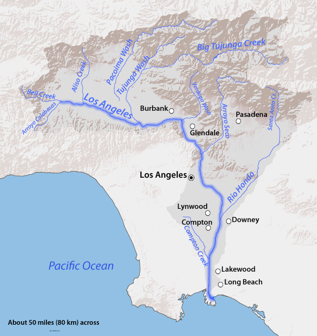 The decanalization has been dubbed 'habitat enhancement' because it's now impossible to restore.
|
|
#
?
Aug 16, 2017 04:56
|
|


|
Los Angeles River? More like �R�o Porci�ncula�. It was named before the city, El Pueblo de Nuestra Se�ora Reina de los �ngeles (sobre el R�o Porci�ncula).
|
|
#
?
Aug 16, 2017 05:07
|
|

|
Jehde posted:
Toronto has a number of these. Here's one.  Taddle Creek is long gone, but the street is still curved. Here's an article with a bunch more maps.
|
|
#
?
Aug 16, 2017 05:11
|
|

|
London has a particularly high number of well‐documented lost rivers. Here�s one surreptitiously crossing the Underground.  Here�s one running through an antique shoppe. 
|
|
#
?
Aug 16, 2017 05:18
|
|
|
Dreddout posted:Imagine being an economic hipster wrt Georgism Matt Yglesias posts on occasion about Georgisn
|
|
#
?
Aug 16, 2017 06:18
|
|


|
I found an interesting trove of maps today. Some of them are cool reconstructions of maps according to various ancient Greeks and then there are a bunch of maps showing the extent of various turkic peoples. In particular, there is a series of maps of Volga Bulgaria that seems uh. . . optimistic. http://s155239215.onlinehome.us/turkic/btn_GeographyMaps/MapsEn.htm  
|
|
#
?
Aug 16, 2017 06:54
|
|

|
Platystemon posted:
SaltyJesus posted:I found an interesting trove of maps today. Some of them are cool reconstructions of maps according to various ancient Greeks and then there are a bunch of maps showing the extent of various turkic peoples. In particular, there is a series of maps of Volga Bulgaria that seems uh. . . optimistic. steppe_wolfe.exe
|
|
#
?
Aug 16, 2017 07:01
|
|


|
mobby_6kl posted:Last week a former mayor of a 25k town and a current deputy something or other called the cops on a black couple walking down the street. According to his own facebook post, he followed them and interrogated them about who they are, what are they doing there, and if they are Muslim. At this point he called the cops to have them check the identity of the couple. At least the cops said that the color of someone's skin isn't "probable cause" enough. I hope this shithead got fined for wasting the police's time. quote:"Asian" is definitely Vietnamese and to a lesser degree Chinese in this case, but I don't think the generic term is used much at all, usually it's a specific nationality. I understand Vietnamese is one of the official languages in Czechia, which, uh. I assume it's a Cold War thing.
|
|
#
?
Aug 16, 2017 07:12
|
|


|
No, but anybody can ask for an interpreter (though that should be the same in all EU countries AFAIK). But otherwise yes, the Vietnamese community was built from the legacy of Cold War educational exchange programs.
|
|
#
?
Aug 16, 2017 07:22
|
|
|
Peanut President posted:So you guys have been explaining Czechia but what about Slovakia? We're just racist. Our neo-Nazi party received 8% in the latest election, another 8% went to the "more civilized" nationalists, who are part of the governing coalition. 6% went to a rich weirdo who got famous for having 8 children with 8 women and making FB videos railing against Muslims. Neo-Nazi leader Marian Kotleba was elected governor in Banska Bystrica region. After the migration wave in 2014 every major party except for the Hungarians went hard right, even the ruling social democrats. Many people still hold WW2-era president Tiso in high esteem. After the revolution a buch of "historians" popped up and tirelessly worked to rehabilitate the fascist regime. Some pics of the local fash:  The fat dude in the white shirt is Marian Kotleba, the leader of LSNS (People's Party - Our Slovakia).  This one is a bit older. from when they were called Slovensk� Pospolitos� (Slovak Community). They used to get banned and rebranded under another name several times. Bonus: 
vetinari100 fucked around with this message at 08:20 on Aug 16, 2017 |
|
#
?
Aug 16, 2017 08:13
|
|

|
What is it with these Wehraboos and tiki torches, don't they see how ridiculous they look?
|
|
#
?
Aug 16, 2017 08:18
|
|
|
steinrokkan posted:What is it with these Wehraboos and tiki torches, don't they see how ridiculous they look? They�re the only torches that are readily available these days and lol no.
|
|
#
?
Aug 16, 2017 10:42
|
|
|
Platystemon posted:They�re the only torches that are readily available these days and lol no. At least peel off the loving stickers, lol
|
|
#
?
Aug 16, 2017 10:49
|
|
|
Platystemon posted:They�re the only torches that are readily available these days and lol no.  We made torches like that as kids. They don't get to claim they're traditionalists rejecting modern degeneracy if they're going to Home Depot instead of spending 5 minutes soaking a stick.
|
|
#
?
Aug 16, 2017 10:50
|
|


|
Do they make fun of Marian Kotleba for having a girl's name
|
|
#
?
Aug 16, 2017 10:53
|
|
|
Guavanaut posted:Just lol if you can't manage to do this. You�re not wrong. Juggling torches are the superior lazy boy�s option. But I want them to roll their own because many of them would gently caress it up and burn themselves. I guarantee it.
|
|
#
?
Aug 16, 2017 11:06
|
|
|
Phlegmish posted:Do they make fun of Marian Kotleba for having a girl's name It's not a girl's name over here. The feminine version would be Mariana/Marianna. But they make fun of him for not being able to pronounce the letter R correctly. Platystemon posted:But I want them to roll their own because many of them would gently caress it up and burn themselves. I guarantee it. That's why there's a guy with a fire extinguisher ready on the left, I guess.
|
|
#
?
Aug 16, 2017 11:21
|
|
|
vetinari100 posted:That's why there's a guy with a fire extinguisher ready on the left, I guess. 
|
|
#
?
Aug 16, 2017 11:30
|
|
|
Duckbag posted:Ditto. I thought I knew the Somalia pseudo-states. Guess not. An effort post would be appreciated, actually. I'm pretty ignorant. there was a great effortpost which would now be extremely out of date from the lf glory days of 2009ish, i'll see if it's not archived anywhere
|
|
#
?
Aug 16, 2017 12:00
|
|

|
Jehde posted:
  These would be even better if they extended further up the Charles or if there'd been proper survey of the terrain heights while little filling sand hill shearing off had happened, but alas.
|
|
#
?
Aug 16, 2017 12:27
|
|

|
vetinari100 posted:But they make fun of him for not being able to pronounce the letter R correctly. lmao is this just a natural law of the slav lands that the dudes who can't pronounce R properly are insecure fights-prone idiots
|
|
#
?
Aug 16, 2017 12:38
|
|
|
Jehde posted:Post how your city has majorly hosed up natural terrain. My native (Washington) DC is built on a swamp but everybody seems to work on a hill. Weird! If you look back to the 1820s, you can see that the President's House is prime malarial waterfront property along the Tiber Creek. Swamp indeed.  By 1860 things are a lot neater, but still pretty damp; feel free to row a boat right up to the expansive South Lawn of the Executive Mansion. Canals run through Southwest and Southeast west of the Anacostia River, at that time still known as the East Branch of the Potomac. Along its shores the Navy Yard and City Asylum/Jail have been built, the latter grounds to be eventually redeveloped into RFK Stadium and the DC Armory. The jail is still there, too.  Finally by the mid-1880s DC is starting to look familiar to modern eyes. The Tiber Creek has been filled in and become flood-prone park land traced with footpaths. The President's House (it still won't be officially called the White House until 1901) is now boxed in by the encroaching of E Street and a chunk of the South Lawn has been remodeled into the Ellipse. Canals are starting to be replaced by streets and the creeks, faintly visible on the older maps, that drain from the higher elevations to the north have been paved over. They still exist today underground to some extent and buildings along their paths pump out a lot of groundwater.  The downtown DC of today: maybe the most expensive swamp on earth, drained in all but metaphor (except when Metro floods). 
glynnenstein fucked around with this message at 14:04 on Aug 16, 2017 |
|
#
?
Aug 16, 2017 14:00
|
|


|

|
|
#
?
Aug 16, 2017 16:53
|
|

|
Unless there's a big one I missed, the politically-loaded elements are pretty subtle so I don't know which you want to call out. 1) the development of the southern islands 2) the development of the Mainland side 3) the ecological impact of reclaiming land in general 3) the way "South China Sea" got shoehorned in there 4) the use of Mandarin transliterations for all Mainland locations regardless of the local language 5) the bait-and-switch politics of the "Special Administrative Region" designation... e: if they'd included the bridge to Hong Kong that would've been a huge one. Whiz Palace fucked around with this message at 20:02 on Aug 16, 2017 |
|
#
?
Aug 16, 2017 19:58
|
|

|

|
|
#
?
Aug 16, 2017 20:32
|
|


|
What the gently caress Mexico
|
|
#
?
Aug 16, 2017 20:36
|
|


|
The longer I look, the less I understand of this map.
|
|
#
?
Aug 16, 2017 20:53
|
|

|
I want to see this given the full treatment from that one guy who had that website where he write up the climate and that stuff for an Earth with inverted elevation, a terraformed Mars etc. e: http://www.worlddreambank.org/P/PLANETS.HTM frankenfreak fucked around with this message at 22:03 on Aug 16, 2017 |
|
#
?
Aug 16, 2017 21:02
|
|
|
I mean, granted the South African accent is barely intelligible but they probably belong in the Anglosphere anyway.
|
|
#
?
Aug 16, 2017 21:20
|
|


|
1) CIS is an actual organization dominated by russia. Instead of it being lots of former soviet states its sub-saharan africa? I don't see why Mexico and central america would be there instead of the latin league. 2) Brazil gets lumped in as usual. Guyana and suriname are one country now? French guyana escaped though! 3) Where does israel end up, I don't see it? I think only the anglosphere would take them. 4) What the gently caress is going on east of europe? It looks like a cutaway of GB. 5) I really don't know what stateless states is suppoed to be.
|
|
#
?
Aug 16, 2017 21:56
|
|

|
Count Roland posted:3) Where does israel end up, I don't see it? I think only the anglosphere would take them.
|
|
#
?
Aug 16, 2017 21:59
|
|
|
Guavanaut posted:They're already in Eurovision (irl, can't see them on the map). If you look carefully, some 2000 miles off the west coast of Canada
|
|
#
?
Aug 16, 2017 22:28
|
|


|
Count Roland posted:4) What the gently caress is going on east of europe? It looks like a cutaway of GB. It looks like Greenland without the ice sheet.
|
|
#
?
Aug 16, 2017 23:30
|
|


|
I love how Papua New Guinea ended up glommed onto the CIS because why the hell not.
|
|
#
?
Aug 16, 2017 23:39
|
|


|
I gotta admit I can't identify a single one of the stateless state bits
|
|
#
?
Aug 16, 2017 23:50
|
|


|

|
| # ? Jun 1, 2024 18:08 |
|
|
Pretty sure Stateless States is Antarctica. Anglosphere is countries speaking English, Sinosphere is countries speaking Chinese and also a few that would probably not like to be speaking Chinese.
|
|
#
?
Aug 16, 2017 23:56
|
|