


|
Crab Dad posted:The Med can get extremely stormy. I�ve been on a 300ft vessel that snapped one of its mooring lines due to wind and wave action in Gaeta, Italy. I wanna say back in 2013 or 2014 there was an actual hurricane in the Med.
|
 #
?
Sep 26, 2023 01:21
#
?
Sep 26, 2023 01:21
|
|


|

|
| # ? May 10, 2024 02:59 |
|
|
Mr. Nice! posted:It's still crazy to me that as recently as 60 years ago were were still just setting sail from port and making educated guesses about how far we had traveled in any east/west direction and hoped we got where we were going. If you have a good clock (or better, three or more good clocks - but never two clocks) you can be pretty close. You mark the local solar noon and compare it to your clock, which is set to your reference time zone (Greenwich Mean Time traditionally but you can use whatever). If it's 1:40pm in Greenwich when it's noon at your location you can convert that into your longitude quite simply. It's not as precise as GPS but it's a far cry from dead reckoning.
|
|
#
?
Sep 26, 2023 01:37
|
|
|
What did the Polynesians do?
|
|
#
?
Sep 26, 2023 01:43
|
|


|
Bongo Bill posted:What did the Polynesians do? An immense amount of combined knowledge, passed down. Stars, obviously. They knew how currents would change when nearing islands and the regularity they did so. They noticed and followed sea birds that would fan out with the sun and return to a roost at night- sailing with the birds at night and against them at day was common knowledge. Micronesians had the stick charts too. Having taken up stargazing the past few years of working outside at night- it�s amazing how instantly you pick it up. I can name stars and constellations in the sky of places I know and tell directions from them. I can tell what time of year it is too. That�s not a humblebrag- I think everyone would figure it out if it was necessary these days. When that�s critical because there is no gps, and without immense light pollution, well gently caress I�d like to see that
|
|
#
?
Sep 26, 2023 01:59
|
|

|
I think one can do parallel east / west sailings with only the sun and stars.
|
|
#
?
Sep 26, 2023 02:03
|
|

|
Edgar Allen Ho posted:Having taken up stargazing the past few years of working outside at night- it�s amazing how instantly you pick it up. I can name stars and constellations in the sky of places I know and tell directions from them. I can tell what time of year it is too. That�s not a humblebrag- I think everyone would figure it out if it was necessary these days. When that�s critical because there is no gps, and without immense light pollution, well gently caress I�d like to see that The constellations, the mythology of the stars, was literally for finding ones way home and knowing where one was. Bar Ran Dun fucked around with this message at 02:22 on Sep 26, 2023 |
|
#
?
Sep 26, 2023 02:05
|
|
|
Kylaer posted:If you have a good clock (or better, three or more good clocks - but never two clocks) you can be pretty close. You mark the local solar noon and compare it to your clock, which is set to your reference time zone (Greenwich Mean Time traditionally but you can use whatever). If it's 1:40pm in Greenwich when it's noon at your location you can convert that into your longitude quite simply. Clocks really do help, for sure. It's still a far cry from what we have today where we know where the ship is within a yard or so. Traditional sailing techniques are really nifty. It was always fun to use the stadimeter and such to measure distance for underweigh replenishments. Just a nifty lil tool to do trig on the fly for you.
|
|
#
?
Sep 26, 2023 02:19
|
|


|
Kylaer posted:If you have a good clock (or better, three or more good clocks - but never two clocks) you can be pretty close. You mark the local solar noon and compare it to your clock, which is set to your reference time zone (Greenwich Mean Time traditionally but you can use whatever). If it's 1:40pm in Greenwich when it's noon at your location you can convert that into your longitude quite simply. Also nobody needs a local clock once they have radio stations to listen to
|
|
#
?
Sep 26, 2023 03:12
|
|

|
Bongo Bill posted:What did the Polynesians do? Detected the size and direction of prevailing waves by dipping their balls in the ocean. I am not joking. Though there were non-ball techniques as well. The balls story may be modern mythology but I choose to believe it. Navigators did lay in the bottom of their canoe and feel the waves for a while to vibe out their locations though. Grand Fromage fucked around with this message at 03:24 on Sep 26, 2023 |
|
#
?
Sep 26, 2023 03:22
|
|


|
Kylaer posted:but never two clocks What's the story about why two is worse than one?
|
|
#
?
Sep 26, 2023 03:25
|
|


|
Tulip posted:What's the story about why two is worse than one? If you have one clock you go with it. If you have three you know that if two agree and one disagrees those two are probably right. If you have two and they disagree you have no loving clue.
|
|
#
?
Sep 26, 2023 03:26
|
|


|
Grand Fromage posted:Detected the size and direction of prevailing waves by dipping their balls in the ocean. Polynesian equivalent of Magellan: �I�m gonna dip my balls in it!�
|
|
#
?
Sep 26, 2023 03:32
|
|

|
Roman/ancient history: Though there were non-ball techniques as well
|
|
#
?
Sep 26, 2023 04:00
|
|
|
It probably also helped that the Pacific was absolutely full of little groups of islands, so just sailing out a good distance and feeling around for land was more viable than going across the empty Atlantic.Edgar Allen Ho posted:Roman/ancient history: Though there were non-ball techniques as well But even these three animals shall not be hosed (with the non-ball techniques).
|
|
#
?
Sep 26, 2023 04:08
|
|

|
Edgar Allen Ho posted:Roman/ancient history: Though there were non-ball techniques as well
|
|
#
?
Sep 26, 2023 04:43
|
|


|
Mr. Nice! posted:It's still crazy to me that as recently as 60 years ago were were still just setting sail from port and making educated guesses about how far we had traveled in any east/west direction and hoped we got where we were going. It�s not just a spitball. Skilled navigators have been able to place themselves on a 0.2 nautical mile accuracy on a map for like two centuries at least. That�s precise enough to aim for specific inlets on the other side of the ocean, or to navigate to islands like St Helena or Tristan de Cunha that are tiny speks in the middle of nowhere ocean. Vahakyla fucked around with this message at 06:03 on Sep 26, 2023 |
|
#
?
Sep 26, 2023 06:00
|
|
|
Grand Fromage posted:Romans went down the west coast of Africa a bit, they don't seem to have gone too far since there's not much there. Explored the Canary Islands. On the east coast, they went at least as far south as Zanzibar, that was a regular trade outpost. The Indian Ocean had lots of Roman activity, there were Roman outposts in southwest India. Roman trade also went further east, around Malaysia and up the coast of China. There's dispute about if Roman ships were doing this or it was all other middlemen but I am quite certain at least some of it was done by Romans themselves. How did they do this? It�s without a top down view and without a compasd. How in hell did they map it this close on such a large scale?
|
|
#
?
Sep 26, 2023 06:01
|
|

|
Vahakyla posted:How did they do this? It�s without a top down view and without a compasd. How in hell did they map it this close on such a large scale? Well if you look at a lot of the details, they're not really that close, even in Europe. But the map was based on a lot of geographic features that they did know existed, so I don't know what kinds of extra errors you think they would get.
|
|
#
?
Sep 26, 2023 06:25
|
|
|
Humans can�t draw a map of their own neigbhborhood to ant scale nor consistent angle. That�s clearly skilled cartoggraphy. Even combining existing maps would take a lot of skill and knowledge.
|
|
#
?
Sep 26, 2023 06:29
|
|
|
Vahakyla posted:How did they do this? It�s without a top down view and without a compasd. How in hell did they map it this close on such a large scale? Same way a roomba does
|
|
#
?
Sep 26, 2023 06:32
|
|

|
Mr. Nice! posted:It's still crazy to me that as recently as 60 years ago were were still just setting sail from port and making educated guesses about how far we had traveled in any east/west direction and hoped we got where we were going. Just to add on to what people were saying, even before GPS you have various land based systems (most especially LORAN) that get ginned up during the war and then percolate out to civilian vessels after that. Mr. Nice! posted:Clocks really do help, for sure. It's still a far cry from what we have today where we know where the ship is within a yard or so. The important thing to note though is that you typically don't really need to know where your ships is within a yard or so. If you know where you are within a few tens of kilometers (or even a hundred or so if you're a skilled mariner used to looking for the signs of land, especially birds and such) that'll allow you to sail to within sight of wherever you're trying to go, then you use your charts and eyeballs. PittTheElder fucked around with this message at 07:23 on Sep 26, 2023 |
|
#
?
Sep 26, 2023 07:21
|
|

 Yes, it's like a lava lamp.
|
Vahakyla posted:How did they do this? It�s without a top down view and without a compasd. How in hell did they map it this close on such a large scale? Skillz. It was the first book (Ptolemy didn't make a map that we know of, the "Ptolemy" map is based on his book) that used latitude and longitude for places. Longitude was different and is the hard one, but the latitude system he used is more or less the same as we do today, having the equator as 0, and is fairly accurate since you can measure it by stars or shadows. A compass is nice but unnecessary if you know the stars well enough. At least in situations like mapmaking where you're not in a hurry.
|
|
#
?
Sep 26, 2023 08:12
|
|
|
Grand Fromage posted:Skillz. I mean, you still have to have surveyors out taking readings and bringing those back to be compiled into the map. Collecting all that data from such a wide swath of the planet, when nobody can travel very much faster than walking speed, must have been a massive project.
|
|
#
?
Sep 26, 2023 08:35
|
|


|
Lead out in cuffs posted:I mean, you still have to have surveyors out taking readings and bringing those back to be compiled into the map. Collecting all that data from such a wide swath of the planet, when nobody can travel very much faster than walking speed, must have been a massive project. Anaxagoras seems to have managed to get a survey of how much land an eclipse covered ~60 years earlier, don't underestimate those guys.
|
|
#
?
Sep 26, 2023 09:19
|
|
|
The first accurate map of france supposedly had the king say 'you have taken more from me than I have gained in all my wars' because france ended up being 20% smaller than previously supposed
|
|
#
?
Sep 26, 2023 09:48
|
|
|
I imagine maps would be really, really important for pretty much all statecraft as much in classical times as today, and if you put enough maps together with some of your best cartographers at the time you can probably get a reasonable picture of what things look like as well as has been recorded in the maps you have. It probably very much was a massive project, yes.
|
|
#
?
Sep 26, 2023 10:59
|
|
|
Lead out in cuffs posted:I mean, you still have to have surveyors out taking readings and bringing those back to be compiled into the map. Collecting all that data from such a wide swath of the planet, when nobody can travel very much faster than walking speed, must have been a massive project. It would have been a matter of gathering records from.merchants and shipping I imagine.
|
|
#
?
Sep 26, 2023 12:09
|
|


|
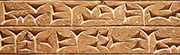
Ghost Leviathan posted:I imagine maps would be really, really important for pretty much all statecraft as much in classical times as today, and if you put enough maps together with some of your best cartographers at the time you can probably get a reasonable picture of what things look like as well as has been recorded in the maps you have. It probably very much was a massive project, yes. So, not quite as much as you might think. Once maps become the norm then yes, maps become really important, but if nobody's using maps then they have pretty low value, which reduces the incentive to make maps and so on. We even have reports of advisors trying to use map-based discussions with their commanders, the commanders finding it completely confusing, and then falling back on the already existing techniques for communicating locations and travel - verbal descriptions of "the x live next to the y" and such. A lot of early maps are more about metaphysics than statecraft, like the ubiquitous TO maps of the medieval/early modern era. 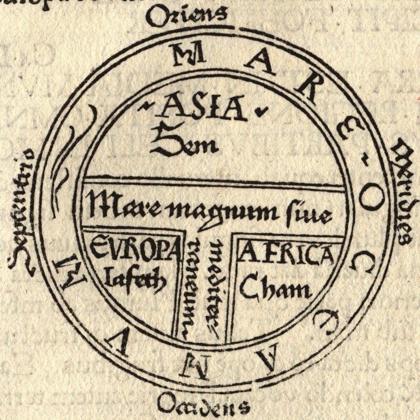 From 1472  From 1581. Even earlier we also see world maps that were less about "how to know where you are and get to other places" than "this is what we wish the world were, theologically." https://en.wikipedia.org/wiki/Babylonian_Map_of_the_World Early Roman maps are often contextualized as fitting into this, most specifically as a way of communicating the glory and expanse of Rome, rather than being practical guides. And we're getting to REALLY the limits of the timeline for this thread but I can't skip it: early European maps of the Americas are fascinating because we can see very obvious political dimensions to the maps. The maps didn't reflect a unified notion of statecraft, but instead the particular interests of whoever was using the map. The most extreme gap is between the kinds of maps American public high schools might highlight, where America is divided into "French," "British," "Spanish," and "Empty" (occasional honorary mention for Russia) and maps that indicate individual native towns and include notes about languages, border checks, passporting/visa regulations, etc. The use for the 2nd type of map is obvious: for people who are actually on the ground in the Americas traveling, mostly merchants and trappers, it is pretty frigging useful to actually know what you're about to walk into and how to get places, both physically and legally. The use for the 1st case is funny and unsurprising, it was to convince people higher than you to invest in your colonialist ventures by both making it seem easy to expand while contextualizing the threat/challenge being other European powers (i.e. your already existing rivals).
|
|
#
?
Sep 26, 2023 13:00
|
|
|
Tulip posted:So, not quite as much as you might think. Once maps become the norm then yes, maps become really important, but if nobody's using maps then they have pretty low value, which reduces the incentive to make maps and so on. We even have reports of advisors trying to use map-based discussions with their commanders, the commanders finding it completely confusing, and then falling back on the already existing techniques for communicating locations and travel - verbal descriptions of "the x live next to the y" and such. A lot of early maps are more about metaphysics than statecraft, like the ubiquitous TO maps of the medieval/early modern era. Also to add to this: You don't need maps if most of your borders are natural. Like: This valley is Roman and Gauls live beyond the river. The logics and logistics of how spaces are conquered make it more likely that borders are natural. Once diplomacy becomes more complicated (and territories get acquired outside of war or threat of war), borders that follow other logic and aren't necessarily defensible or have other military logic become more common. If you expand peacefully (through marriage or inheritance) "borders" are more likely to be in places that are less "natural" in the sense of them following geographical features. And also this: the situation on the ground was more important than the mental model. There wasn't a method of reproducing maps for a very long time anyway, so how would anyone get one that they could trust. Much better to just be able to remember "left bank of the river good, right bank of the river bandit country"
|
|
#
?
Sep 26, 2023 13:21
|
|

|
EricBauman posted:Also to add to this: Also very important that if we're specifically thinking like generals/warriors (and given that most rulers in most countries were some form of military aristocrat, seems reasonable), you basically follow roads and rivers. You don't really have the ability to just cross everything on the 2D plane like in Age of Empires or Total War.
|
|
#
?
Sep 26, 2023 13:25
|
|
|
Hieronymous Alloy posted:It would have been a matter of gathering records from.merchants and shipping I imagine. Yeah, at various local levels one could make a map if they chose to, though for a bunch of reasons multiple posters have mentioned this was either not needed or not worth the effort. But for a greek or roman "science" guy, one could likely acquire a bunch of local maps, sailors maps, road maps, etc and collate them into something like the Ptolemy map. Sailors would likely have more "maps" than other people due to needing to know where safe harbors are. if you collect enough of those, you can likely do a decent job of collating together a map that shows coastlines, which the Ptolemy map does quite well, from that perspective. Toss in things like that Roman map of the world that is like a subway map for roads and one can extrapolate a lot of information if they are dedicated enough.
|
|
#
?
Sep 26, 2023 14:10
|
|

|
Sailors don't have maps at all. They use charts. 
|
|
#
?
Sep 26, 2023 14:48
|
|
|
Tulip posted:Also very important that if we're specifically thinking like generals/warriors (and given that most rulers in most countries were some form of military aristocrat, seems reasonable), you basically follow roads and rivers. You don't really have the ability to just cross everything on the 2D plane like in Age of Empires or Total War. Yeah this is super true. In tv and film you often see the generals looking at a map and planning their route or whatever, but they didn't really conceptualize things that way in the past. They had maps, which were rare, but detailed surveys and maps weren't a thing until the late 18th/early 19th century. They didn't even get the compass in the Mediterranean until the 1300s. Consequently armies basically just stuck to roads and rivers. Partially to orient yourself, and partially because they had to move supplies by wagon or pack animal and it's much more practical to do it that way. Cutting through country was a good way to get lost in foreign territory. Or even familiar territory. Suetonius recorded that Caesar got lost trying to find the Rubicon, spent all night wandering around trying to find it, and ended up needing a guide to get him there, and this is a relative big river like 150 miles from Rome.
|
|
#
?
Sep 26, 2023 14:48
|
|
|
Jamwad Hilder posted:Yeah this is super true. In tv and film you often see the generals looking at a map and planning their route or whatever, but they didn't really conceptualize things that way in the past. They had maps, which were rare, but detailed surveys and maps weren't a thing until the late 18th/early 19th century. They didn't even get the compass in the Mediterranean until the 1300s. Consequently armies basically just stuck to roads and rivers. Partially to orient yourself, and partially because they had to move supplies by wagon or pack animal and it's much more practical to do it that way. Cutting through country was a good way to get lost in foreign territory. Or even familiar territory. Suetonius recorded that Caesar got lost trying to find the Rubicon, spent all night wandering around trying to find it, and ended up needing a guide to get him there, and this is a relative big river like 150 miles from Rome. And Caesar's considered exceptionally good at navigating! He's not some exceptionally dopey schmuck, he's Caesar. Just another small brick in the "stick to roads and waterways," you basically have 3 ways of keeping your army from starving to death. The first is "carrying stuff." You want to stick to roads because its less effort to travel and thus less time spent traveling and thus you can get further from the same limited supply. The second is "pre planned supply caches." Which you almost certainly set along roads because, again, less food wasted on carrying the food, and also because you have to find the drat things. Third and most important is forage. Foraging (in the military context) means going to areas that are already populated, which is where people build roads.
|
|
#
?
Sep 26, 2023 14:54
|
|
|
Mr. Nice! posted:It's still crazy to me that as recently as 60 years ago were were still just setting sail from port and making educated guesses about how far we had traveled in any east/west direction and hoped we got where we were going. No, in 1963 there were plenty of radio navigation aids available. Edit: For that matter, radio navigation was in use before WWI. Cessna fucked around with this message at 15:35 on Sep 26, 2023 |
|
#
?
Sep 26, 2023 14:59
|
|

|
I�ve been to the Rubicon and I can readily believe Caesar couldn�t find it. There�s a mildly impressive modern restoration of a (post-Caesarian) Roman bridge, but the stream barely needs it, it�s tiny. you could probably cross it in some places without getting your feet wet.
|
|
#
?
Sep 26, 2023 14:59
|
|

|
Had maps. We talk about them all the time in here. They didn�t look like satellite geography maps tho.
|
|
#
?
Sep 26, 2023 15:00
|
|

|
skasion posted:I’ve been to the Rubicon and I can readily believe Caesar couldn’t find it. There’s a mildly impressive modern restoration of a (post-Caesarian) Roman bridge, but the stream barely needs it, it’s tiny. you could probably cross it in some places without getting your feet wet. Yeah I should have said "long" rather than "big" - it's definitely shallow, but it's 50 miles long
|
|
#
?
Sep 26, 2023 15:11
|
|
|
Roman maps were fairly rare and more of an art object. I don't think I was clear but the Ptolemy map I posted is a Roman one from like the 1100s. There weren't any map versions prior to the Middle Ages because classical Romans didn't really use maps much. You navigated by routes and travel times, you can see that in the geographical texts and travel guides from the period. Which is still how people navigate. I think a lot of us are the sort of nerd who plays strategy games and overestimate how much maps mean to people. I've shown maps of where I want to go to taxi drivers so many times and the vast majority of them look at it like it's an alien artifact, they have no idea what to do with it. Using a map is a particular skill and it's rarely taught.
|
|
#
?
Sep 26, 2023 16:40
|
|
|

|
| # ? May 10, 2024 02:59 |
|
|
I would call the �geographical texts and travel guides� maps.
|
|
#
?
Sep 26, 2023 16:42
|
|