


|
ulmont posted:Chicago and surrounding areas would be my guess. that's like 150 miles from chicago
|
 #
?
Feb 25, 2024 23:33
#
?
Feb 25, 2024 23:33
|
|


|

|
| # ? Jun 9, 2024 16:14 |
|
|
ulmont posted:Chicago and surrounding areas would be my guess. Chicago is smallish though. Hog country and soy country have a decent amount of overlap, but there is no Illinois gap in soy: 
|
|
#
?
Feb 25, 2024 23:37
|
|

|
Remember that particular map is from 1948, so what's there now isn't going to be much of a factor in where the wild hogs were.
|
|
#
?
Feb 25, 2024 23:48
|
|

|
Civilized Fishbot posted:Does anyone know why the hog cloud cloud isn't contiguous, breaking up over east/central Illinois? Something about that area make it less hospitable to hog-raising/more amenable to a different industry? My first thought was rivers, but also it appears this map sure looks like a 1920 USDA map of pig farms rather than wild pigs, who would probably be split up by a lot of urban areas or industries that find more value in sidling up close to major lines of transportation. More recent USDA maps seem to indicate that pig farming is still really big in Iowa, but for some reason North Carolina has emerged as a major pork producer in the last century.   Whereas in the USDA's maps of feral pigs, they seem to be dominantly way in the south. https://www.aphis.usda.gov/aphis/ourfocus/wildlifedamage/operational-activities/feral-swine/sa-fs-history My guess is that's probably where a lot of pig farmers went out of business, releasing their pigs into the wild.
|
|
#
?
Feb 25, 2024 23:49
|
|

|
SlothfulCobra posted:for some reason North Carolina has emerged as a major pork producer in the last century. quote:[Eastern North Carolina hog farms] are located in rural farming communities that have an abundance of nearby corn and soybeans (the main ingredients in feed) and are within a short drive of pork processing plants. So, the answer is actually somewhat politically loaded! American smoking has been falling since the 1950s, but there was an especially big drop in the 1980s.
|
|
#
?
Feb 26, 2024 00:15
|
|
|
trying to find the article about the guy who did flyovers of all of the bright pink �lagoons� of pig poo poo in va/nc that you can smell from the air and that the advice if somebody falls in is to let them die because if you try to save them you�ll just end up another casualty
|
|
#
?
Feb 26, 2024 01:49
|
|
|
Civilized Fishbot posted:Does anyone know why the hog cloud cloud isn't contiguous, breaking up over east/central Illinois? Something about that area make it less hospitable to hog-raising/more amenable to a different industry? This is a post that could also have been made in the universe where we lost Mexico and Canada to the hogs
|
|
#
?
Feb 26, 2024 02:17
|
|


|
Can anyone tell me how big of an influence soybean producers have on the government of South Dakota,? I wanna know how much to worry about Big Soy
|
|
#
?
Feb 26, 2024 03:44
|
|

|
BonHair posted:Was it these scribbles that caused the amazing enclaves around (on? The prepositions feel weird) the border? I think they straightened it out recently, but I remember third level enclaves going on. You're thinking of the border between India and Bangladesh (previously East Pakistan), which did have a single third-order enclave involved. Most of those (including the third-order enclave) were abolished when the border was simplified in a 2015 agreement. iirc from when I last read up on this, the funky border situation actually pre-dated British colonization of the area, with the reason for it being uncertain and unrecorded. The legend around it is that the neighboring pre-colonial lords liked to use small parcels of land as wagers in games with each other. edit: on checking again, the land-wager thing is a common popular legend, but the more likely cause was apparently a poorly-written treaty in the early 1700s that effectively froze the temporary territorial gains of the war it ended. edit 2: Just so my post has a map, here's Wikipedia's map for Dahala Khagrabari, which was the world's only third-order enclave when it existed! It was apparently just an unpopulated field. 
Mr. Belpit fucked around with this message at 04:16 on Feb 26, 2024 |
|
#
?
Feb 26, 2024 04:06
|
|
|
Mr. Belpit posted:You're thinking of the border between India and Bangladesh (previously East Pakistan), which did have a single third-order enclave involved. Most of those (including the third-order enclave) were abolished when the border was simplified in a 2015 agreement. Dear Valentine, I want to mix our flesh like India and Bangladesh
|
|
#
?
Feb 26, 2024 04:30
|
|


|
I know I shouldn't still be getting surprised by the Mercator projection, but I've been reading about Southeast Asia lately and decided to look up the Malay Archipelago up on truesize out of curiosity and was slightly mind-blown:
|
|
#
?
Feb 26, 2024 04:55
|
|

|
The island of Borneo is about the size of France, but with a third of the population, around the size of Taiwan or Romania.
|
|
#
?
Feb 26, 2024 05:03
|
|
|
Koramei posted:I know I shouldn't still be getting surprised by the Mercator projection, but I've been reading about Southeast Asia lately and decided to look up the Malay Archipelago up on truesize out of curiosity and was slightly mind-blown: yo looks at this goons flaccid papua
|
|
#
?
Feb 26, 2024 05:29
|
|

|
Things as wide as the USA from NYC to San Francisco 1. Indonesia 2. The Sahara 3. The Mediterranean 4. Chile (on its side)
|
|
#
?
Feb 26, 2024 06:50
|
|
|
5. Your mom
|
|
#
?
Feb 26, 2024 06:58
|
|

|
6. The Moon (almost)
|
|
#
?
Feb 26, 2024 07:03
|
|


|
If the universe were scaled down such that the Sun shrunk to the size of a softball on home plate at PacBell Park in San Francisco, Earth would be a large grain of sand, about a millimetre in diameter, just short of the pitcher�s mound. The nearest neighboring star, Proxima Centauri, would be in New York City.
|
|
#
?
Feb 26, 2024 07:12
|
|
|
Platystemon posted:If the universe were scaled down such that the Sun shrunk to the size of a softball on home plate at PacBell Park in San Francisco, Earth would be a large grain of sand, about a millimetre in diameter, just short of the pitcher�s mound. That explains the pizza situation around Proxima. It's getting so you can't find a decent Chicago-style deep-dish anywhere outside the drat Oort cloud.
|
|
#
?
Feb 26, 2024 07:19
|
|
|
Platystemon posted:If the universe were scaled down such that the Sun shrunk to the size of a softball on home plate at PacBell Park in San Francisco, Earth would be a large grain of sand, about a millimetre in diameter, just short of the pitcher’s mound. How large would the earth and the sun be if we pictured them as a hot dog bun, or a bag?
|
|
#
?
Feb 26, 2024 07:43
|
|


|
Badger of Basra posted:I would simply divide up a united and heterogenous ethno-linguistic region in a way that minimizes disruption and death I mean, this was not really possible to do. The Brits and French did this with the Treaty of Lausanne and people are still bitching about that more than 100 years later (usually, idiots who call it Sykes-Picot), even though it was designed primarily around local ethno-linguistic boundaries. Try setting a good boundary today between Red America and Blue America, or in 1960 between Black America and White-Passing America (and who knows wtf to do with Asians in that model). That wouldn't have worked either in large sections. Turns out setting country boundaries is hard. And not having country boundaries is also pretty bad, historically, vis-a-vis it set the stage for tons of horrific wars. Saladman fucked around with this message at 08:22 on Feb 26, 2024 |
|
#
?
Feb 26, 2024 08:19
|
|
|
Brits were actively encouraging animosity between Hindus and Muslims before decolonization because Hindu and Muslim students were united in protesting British colonial rule and the Brits figured "if we can get them fighting each other they won't fight us as much."
|
|
#
?
Feb 26, 2024 08:49
|
|

|
It's pretty standard stuff for autocratic imperial rule to play groups against eachother by their identity to maintain power, even while the structure of an imperial state makes people from across the empire mix and stew in a way that'd be hard to separate afterwards. The whole system of maintaining power is about sabotaging the potential for something to come afterward right up until the empire is gone and something has to come afterwards. Of course when the British arrived, they butted into the waning days of the Mughal empire, who had their own autocratic order centering on maintaining power, and I suppose now decades after the British left, we still have the lands they occupied in the hands of autocrats trying to forcibly suppress dissent. There's just a lot of bad people out there ready to grab hold of power at any cost, and it's hard to really get the ball rolling against that.
|
|
#
?
Feb 26, 2024 09:03
|
|
|
Mr. Belpit posted:iirc from when I last read up on this, the funky border situation actually pre-dated British colonization of the area, with the reason for it being uncertain and unrecorded. The legend around it is that the neighboring pre-colonial lords liked to use small parcels of land as wagers in games with each other. i mean it could just be regular old real estate bought and sold by different local lords, they werent always contiguous. we had a lot of that in europe as well so idk why it has to be a weird funny reason like gambling Slesvig-Holsten was a hot mess, down to individual farms belonging at times either to a duchy, or the king as duke or personally, or the danish kingdom, with all that follows (taxes, courts, etc). see also https://en.wikipedia.org/wiki/Baarle-Hertog
|
|
#
?
Feb 26, 2024 11:25
|
|


|
Saladman posted:I mean, this was not really possible to do. The Brits and French did this with the Treaty of Lausanne and people are still bitching about that more than 100 years later (usually, idiots who call it Sykes-Picot), even though it was designed primarily around local ethno-linguistic boundaries. Yes that�s the joke behind the �I would simply� meme format
|
|
#
?
Feb 26, 2024 14:30
|
|
|
Teriyaki Hairpiece posted:Can anyone tell me how big of an influence soybean producers have on the government of South Dakota,? I wanna know how much to worry about Big Soy I think they currently have an awkward relationship with it due to the importance of China for their exports. East River, corn would still be more important. I can�t imagine too many West River politicians care about soy much at all unless it happened to impact the big ranchers.
|
|
#
?
Feb 26, 2024 15:08
|
|


|
Badger of Basra posted:Yes that�s the joke behind the �I would simply� meme format Ah, wasn't familiar with that meme format, even after Googling it.
|
|
#
?
Feb 26, 2024 17:23
|
|
|
Civilized Fishbot posted:Does anyone know why the hog cloud cloud isn't contiguous, breaking up over east/central Illinois? Something about that area make it less hospitable to hog-raising/more amenable to a different industry? Consistent rumours of fentanyl production scared off a lot of the hogs to work elsewhere.
|
|
#
?
Feb 26, 2024 17:23
|
|


|
Saladman posted:I mean, this was not really possible to do. The Brits and French did this with the Treaty of Lausanne and people are still bitching about that more than 100 years later (usually, idiots who call it Sykes-Picot), even though it was designed primarily around local ethno-linguistic boundaries. What's wrong with referring to Sykes-Picot? It helped define much of the post war middle East and pretty well exemplifies how dumb empires can be.
|
|
#
?
Feb 26, 2024 17:35
|
|

|

|
|
#
?
Feb 26, 2024 17:40
|
|


|
Count Roland posted:What's wrong with referring to Sykes-Picot? It helped define much of the post war middle East and pretty well exemplifies how dumb empires can be. It did, but it was also never implemented in the face of the backlash after the Soviets published it. The actual borders that get drawn at San Remo are also very different in important ways.
|
|
#
?
Feb 26, 2024 19:01
|
|

 Yes, it's like a lava lamp.
|
Saladman posted:Ah, wasn't familiar with that meme format, even after Googling it. I would simply know all the memes This map must have been drawn by an Italian. Credit for having Turkey kinda shaped like a Turkey though.
|
|
#
?
Feb 26, 2024 23:15
|
|

|
PittTheElder posted:It did, but it was also never implemented in the face of the backlash after the Soviets published it. The actual borders that get drawn at San Remo are also very different in important ways. Yeah, several treaties took its place and several of the plans didn't make it through. Still, I think without listing several treaties the term Sykes-Picot does the best job of summarizing the imperialist double dealing that led to the middle east we have today.
|
|
#
?
Feb 27, 2024 00:59
|
|
|
drk posted:So, the answer is actually somewhat politically loaded! American smoking has been falling since the 1950s, but there was an especially big drop in the 1980s. just smoke the pigs, in more ways than one
|
|
#
?
Feb 27, 2024 02:47
|
|


|
 I�m a section of Chihuahua, M�xico.
|
|
#
?
Feb 27, 2024 04:10
|
|
|
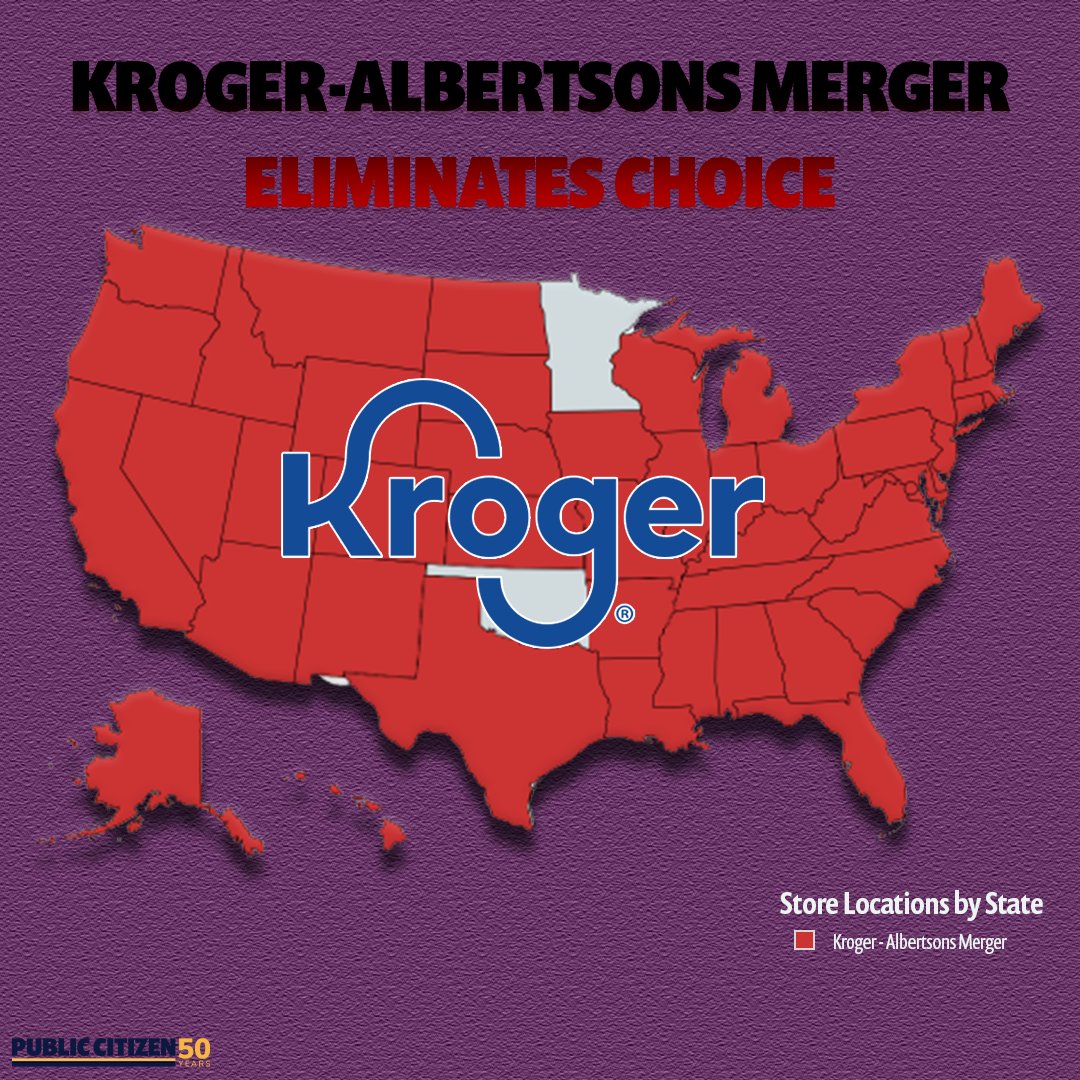
I don't know what Kroger is but I'm guessing they sell hogs?
|
|
#
?
Feb 27, 2024 09:36
|
|

|

|
|
#
?
Feb 27, 2024 09:50
|
|
|
kiminewt posted:I don't know what Kroger is but I'm guessing they sell hogs? If you live in America they own most grocery stores, and might literally own all of them soon.
|
|
#
?
Feb 27, 2024 10:04
|
|
|
There are many strong regional chains that are not Kroger's or Albertsons.
|
|
#
?
Feb 27, 2024 12:26
|
|


|
True. Lots of Gwep's and Food Mommys where I live.
|
|
#
?
Feb 27, 2024 13:57
|
|
|

|
| # ? Jun 9, 2024 16:14 |
|
|
 Great color coding there 
|
|
#
?
Feb 27, 2024 14:57
|
|
