


|
Hi thread, a kind goon in the ancient history thread pointed me in this direction because I posted about a game I've been working on as a hobby to do something constructive in my (limited) free time. That is a great OP, xopods; I love and appreciate that someone is aggregating all that information and there is a thread here to talk about game design. I'm sure I'll be posting more when I get the chance, but I figured I would toss this out there as a website I found that looks to be a game-maker's resource: https://www.boardgamesmaker.com. I have not used it yet but I may use it to print a map and some chits for one of the games I am working on simply because a having a physical copy of a project I've been working on, off-and-on, for a couple of years would be exciting.
|
 #
¿
Feb 3, 2022 02:34
#
¿
Feb 3, 2022 02:34
|
|


|

|
| # ¿ May 21, 2024 01:30 |
|
|
Hi thread, I'm new here and the thread has been pretty quiet the past few weeks but I want to post about a game I am working on, so here goes. I've read the op but let me know if I do anything wrong or anything like that. The goal of this post is to share my basic outline of, and a map for, a board game idea I have to solicit some basic feedback and to see if any vets of the game that provides inspiration have any thoughts. I'm a huge fan of "Tresham Civ". I played it a ton in the 2000s and still have many fond memories. A basic breakdown for those unfamiliar: Each player starts the game with 1 pop token in the year 8,000 BCE; the game spans through to ~250 BCE. Every turn, each pop doubles, up to two per region. Eventually players start consolidating 6 or 12 pops into one region to build a city, which they can have up to 9. Players have to compete and/or negotiate for land to make sure they have the room they need for their pops and their cities. Combat between players is simple - to attack, one player moves pops into a region owned by another player; they then take turns removing a pop until they cohabitate in the region (the combined number of pops left equals what can be supported in the region) or all pops of one player are removed (this means no dice, which I love because dice hate me). Each city provides a trade good - you get a 1 value trade good for one city; a 1 and a 2 value for having two cities; a 1, 2, 3, 4, and 5 for having five cities, so you want to get to nine cities for the highest value cards. Each turn players take a break from being the god emperor of their civilization to trade I would love a modern version with a faster play time and a sane-r map. I've been working on a number of board game ideas for a while and I've used them to try to teach myself some different skills; I decided it was time to learn "The Free Photoshop", GIMP, so I decided to teach myself GIMP by making a map for a spiritual successor to Tresham Civ. My goals for the map were to have Persia be a bigger part of the map, have regions be a sane shape & size, and make terrain & climate have a place. To that end, the map contains more of the Iranian plateau; regions are, mostly, roughly hexes (none of these "5 (or more) times longer than they are wide" monstrosities) that are all reasonably close to being the same size; and each province's pop max icon is color coded according to their primary climate & defining terrain type. The climate & terrain is broken down like so: + Blue: Riverlands; the region is dominated by a major river + Orange: Dry Hills; the region is dominated by hills, the occasional mountain, and plateaus but water is scarce + Dark Green: Lush Hills; the region is dominated by hills, the occasional mountain, and plateaus where water is abundant + Yellow: Drylands & Desert; the region is dry and devoid of major sources of fresh water + Light Green: Grasslands; the region is mostly flat and has water sources, but is not dominated by any specific body of water + Grey: Mountain; soaring peaks of a mountain range dominate the region One other thing I should mention about the map at this point (it may change but I pretty much need to playtest at this point to know if I'd want to change it) is that the expectation is that techs will increase the number of pops that can live in a region. Thus, the highest base number you see is a 3 (Tresham Civ goes up to 5) but techs will let you eventually, say, double the Flood Plain regions but wont do much for the deserts. Also, the regions with a blank yellow icon are that way intentionally - even in antiquity the Libyan desert was pretty much uninhabitable, the northern Arabian peninsula was mostly arid desert, and the land to the east of Tehran was a wasteland; there will be a tech for these regions so they can support 1 pop, and maybe a later tech so pops there can reproduce. Here is the map:  I did some changing of the coastlines to reflect differences because of time, though I will admit I have not done the best job of that because the game spans a several thousand years. Thanks to some goons in the Roman/Ancient History thread I made some changes because of things like this: https://upload.wikimedia.org/wikipe..._map-en.svg.png (image removed to keep post tidy). Any feedback on the map is welcome, as are questions. Key things I want to do that will be different than Tresham Civ:
Edit: I'm not sure if this is too much in one post or not enough, so let me know if you have questions! AAAAA! Real Muenster fucked around with this message at 22:04 on Feb 21, 2022 |
|
#
¿
Feb 21, 2022 21:21
|
|
|
CommonShore posted:That's a lot to take in - what parts of the game are you working on right now?
|
|
#
¿
Feb 22, 2022 19:07
|
|
|
Pulling this in here from a different thread:FulsomFrank posted:
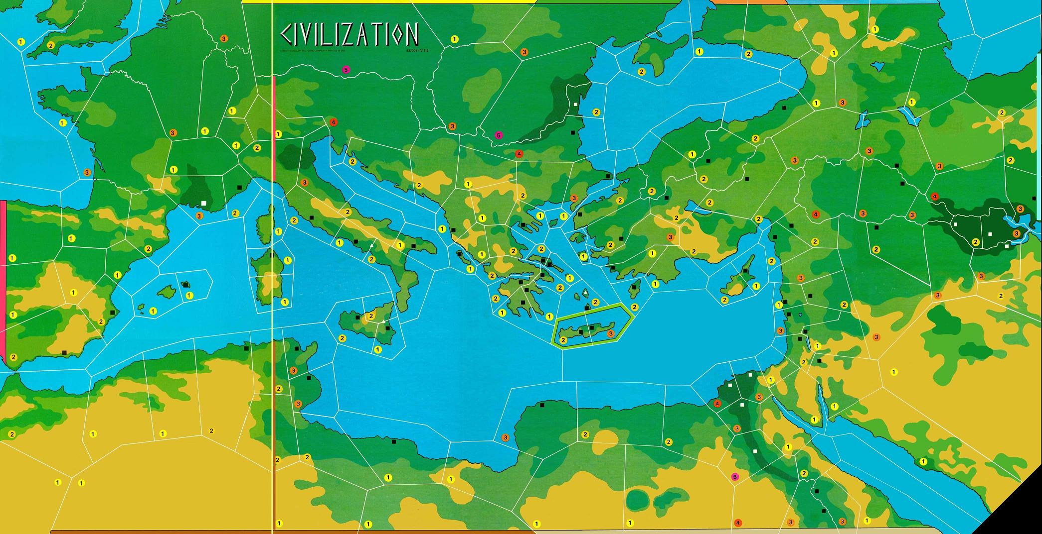 Here is a cleaned up and updated map of mine (I embellished the rivers and cleaned up some coastline earlier but zoomed out you can barely tell  ): ): I had just posted it recently in the thread, but for sake of reference, here is the scheme for the region value color coding: + Blue: Riverlands; the region is dominated by a major river and its alluvial plain + Orange: Dry Hills; the region is dominated by hills, the occasional mountain, and plateaus but water is scarce + Dark Green: Lush Hills; the region is dominated by hills, the occasional mountain, and plateaus where water is abundant + Yellow: Drylands & Desert; the region is dry and devoid of major sources of fresh water + Light Green: Grasslands; the region is mostly flat and has water sources, but is not dominated by any specific body of water + Grey: Mountain; soaring peaks of a mountain range dominate the region Having heard feedback from other people that the bizarre shapes on Tresham's civ map were strange and off putting, as well as having the same experience as you in the Aegean several times (my first game ever was as Crete, heh), and being a fan of hex games, I decided to base the shapes of the provinces I made on being, essentially, hexes. This prevents situations where that huuuuge 3 value inland Syrian region borders a whopping 10 other regions (and consequently is a major bottleneck) or the obscenely long-but-narrow 4 value province in the Balkans is just weird. Another goal was to fix something that annoys the hell out of me with many games where the rougher/mountainous regions and/or poorer regions are *larger* than well developed regions that have rivers and would have roads; a larger province means your pops/units are travelling greater distances across the map in less time. Essentially, it hurts my brain when you can walk from Aqaba to Nineveh in the same amount of time you can walk from Sparta to Athens like how the Tresham map above works. So I put more time and thought than I'd like to admit into how these wobbly hexes are both shaped and sized - hilly/mountainous tend to be smaller and have a lower pop cap to account for less land area and less arable land. Some of the provinces in the northern part of the Iranian Plateau are slightly elongated in such a way that it is easier/faster to travel south east to north west due to how the valleys in the region are shaped. I realized what making them all hexes would do, because, well, they're hexes, thats the point of a hex! And I wanted things to be a bit more connected because this is based more around the Fertile Crescent rather than the med. But I had not realized that doing it this has drastically increased the connectivity of each region compared to Tresham civ, which could definitely have an impact on gameplay. So now I have a lot of thinking to do. And real quick since I have some more time, the region values I did trying to model reality as best I could (my verisimilitude backbone  ), while trying to keep the balance of large areas of the map in mind, and account for how my map has fewer regions in, say, Greece compared to Mesopotamia as compared to Tresham's map, so the numbers would have to be higher in Greece to account for there being fewer regions. I also have places where historically there was the seat of an empire or a major influential city a higher base value (places like Nineveh, Troy, Athens, Damascus, Shiraz, Tabriz, Crete, Sinop, Southern Macedonia, Byzantium (even though it was big after the game's timeframe)). Another thing my friends and I found odd was some of the pop max values that Tresham had - as many people can live on the tiny Aegean island of Lemnos (and Imbros and Samothrace) as can live in Naples? More people can live on the island of Euboea than can live in Rome? The part of Sicily where Syracuse (one of the largest Greek polises ever) is a 1? The values of the Egyptian Nile regions seem completely arbitrary. It literally has not rained more than once a year in the Libyan desert (the most arid and inhospitable part of the Sahara) since like 6,000BCE but it has a bunch of 1s and 2s meanwhile the coast of Algeria has a Mediterranean climate and can, and did, support large population centers, and was the granary of Rome for centuries, but is a bunch of 1s and 2s. I could go on but I'm sure you get the point. Other than the northern Mesopotamian plain being a large chunk of 2s and the Nile and Tigris+Euphrates systems being a bunch of 3s, I feel like there is decent number variety? With the idea that pop caps will end up being doubled by tech for flood plains and up the limit by 1 or 2 in Grasslands and Lush Hills, the differences will stand out more as the game goes on (is the hope...). ), while trying to keep the balance of large areas of the map in mind, and account for how my map has fewer regions in, say, Greece compared to Mesopotamia as compared to Tresham's map, so the numbers would have to be higher in Greece to account for there being fewer regions. I also have places where historically there was the seat of an empire or a major influential city a higher base value (places like Nineveh, Troy, Athens, Damascus, Shiraz, Tabriz, Crete, Sinop, Southern Macedonia, Byzantium (even though it was big after the game's timeframe)). Another thing my friends and I found odd was some of the pop max values that Tresham had - as many people can live on the tiny Aegean island of Lemnos (and Imbros and Samothrace) as can live in Naples? More people can live on the island of Euboea than can live in Rome? The part of Sicily where Syracuse (one of the largest Greek polises ever) is a 1? The values of the Egyptian Nile regions seem completely arbitrary. It literally has not rained more than once a year in the Libyan desert (the most arid and inhospitable part of the Sahara) since like 6,000BCE but it has a bunch of 1s and 2s meanwhile the coast of Algeria has a Mediterranean climate and can, and did, support large population centers, and was the granary of Rome for centuries, but is a bunch of 1s and 2s. I could go on but I'm sure you get the point. Other than the northern Mesopotamian plain being a large chunk of 2s and the Nile and Tigris+Euphrates systems being a bunch of 3s, I feel like there is decent number variety? With the idea that pop caps will end up being doubled by tech for flood plains and up the limit by 1 or 2 in Grasslands and Lush Hills, the differences will stand out more as the game goes on (is the hope...).edit:  this ended up being a wall of text. Though I guess that is bound to happen in design! this ended up being a wall of text. Though I guess that is bound to happen in design!
AAAAA! Real Muenster fucked around with this message at 05:04 on Mar 8, 2022 |
|
#
¿
Mar 8, 2022 04:45
|
|

|
FulsomFrank posted:I know where you're coming from with regard to striving for verisimilitude but at the end of the day I would advise against sticking to it hell or high water because don't forget, at the end of the day you're trying to make a game that is fun. If you cannot square the circle of creating interesting decisions because you've staked your reputation on ensuring that historical regions line-up with accurate population caps/fertility that in turn leads to overly linear or uninteresting bunching of numbers in a certain spot... just ignore it! Go wild and address the change in designer's notes. No one cares unless it's so off-base that it becomes distracting. Regarding tech - yes, I am currently worried I may be too far in the direction of adding complexity where it would not be of great benefit, but at this point I need to see it play out to get a feel for how it feels with everything else going on. I'm planning on having techs that increase the population limit of one or two types of terrain, where if there are multiple techs that affect the same type, they will literally stack on top of each other (so each player's play area is not cluttered as badly with tech cards), e.g. basic Irrigation adds +1 pop cap on Grasslands (light green) and Flood Plains (blue) and Advanced Irrigation upgrades that to +2, so Advanced Irrigation will sit on top of Basic. One design goal of mine is to have tech in play earlier in the game to cut down or cut out the commodity trading, because though it is fun it is time consuming and gives an advantage to loud and/or forceful and/or silver-tongued people who can aggressively trade up and take off like a rocket after a few turns of trading. Silver-tongued people already have an advantage peacefully negotiating for land rights and forceful people will have more options for military (see below). Though if the whole thing with techs upgrading the pop max of certain region types turns out to be too complex I may have to ditch it and go back to my original idea where the color of the region can affect what calamities can happen there. So to address all that I'm adding a mechanic where players earn "Culture Points", based on how many pops they have and from each city. Techs will cost culture points to acquire and early techs will be pretty cheap so you can start acquiring them early, though there will not be the color groupings where a green tech makes other green techs cheaper to cut down on the shenanigans you can get up to with that. I'm considering having it so later techs cost a significant number of culture points and you can trade in sets of trade goods to get a burst of Culture Points that you cannot store, but I feel like I need to playtest the basic gameplay loop and early techs before I nail down how I want to do the late-game things. One idea I wanted to note is my idea for boats - they will be abstracted. You will have a capacity for how many pops can move over water in a turn, and how far. You spend Culture Points during the tech buying phase to increase these numbers. Less clutter on the board, fewer pieces to manage, and something to invest in if you want to go sailing. I have a lot of different ways I could go with tech but I am trying really hard to not be married to one particular thing because my main goal is to have a fun core gameplay loop. I want the tech to honestly be ultimately pretty simple, but we'll see if I can pull it off. One thing I'd like to add is more military techs which will also help signify the ages - I'm essentially taking the military tech card ideas from Age Of Renaissance (AoR) (where combat is exactly the same as Tresham Civ) where if you play something like "Stirrups" or "Gunpowder" you get an advantage in combat for one turn - your opponents lose a pop chit before you start the standard exchange process; for my game, that mechanic from AoR would be modified where if you buy the "Bronze Weapons and Armor" tech you 'permanently' get the same advantage in combat as described for AoR - your opponent loses a chit first, then combat resolves as normal; your opponent can negate that advantage by also acquiring the tech. These techs would stack just like how I described the Irrigation techs, so if you get the next military tech after Bronze, you'd simply place it on top of the Bronze card and it shows your total bonus (less clutter, less math, only have to look in one spot to see what modifier you have). Something I did with the map is remove city sites because I feel like those are super artificial, like homullus points out in his post (more on that below), the situation of a city in any given location is less about the location being suitable for a large city and more about culture, technology, and man-made infrastructure. What I am hoping to playtest soon is having it so cities have a base cost of 12 to build, and can be built anywhere, but, there will be some early techs that reduce the cost of building a city. So the game will start off a bit slower because players cannot just rush cities onto every nearby city site, but will allow me to build it so players feel a sense of progression where as they acquire techs that make doing the basic gameplay loop easier. I'm also going to do it so pops can still live in regions where there is a city, but they dont populate, and have it so cities cost pop upkeep (to model how cities generally pull people in from the countryside). I'm hoping, but not married to, the idea of having multiple viable tech paths for picking how you want to focus on pop growth/max-per-region, city cost, city upkeep, and anything else along those lines that will gradually impact your basic gameplay loop. homullus posted:It seems to me that you are looking at some of the maximum populations in a bit of an odd way. You are looking the Romes of the world -- places that eventually housed very large numbers of people -- and deciding that it was the land itself that determined that population, rather than culture, technology, infrastructure, and land. Euboea at its height was dwarfed by Rome at its own height, but Rome at its height had aqueducts, roads, blahblahblah; in 800 BCE, though, Euboea was a big deal, with the Greek alphabet likely being invented there (possibly to write down Homer), while Rome at the time probably still had separate tiny settlements on each of its tiny hills. I mean, consider your point about the coast of Algeria: you say it should have a higher max because it was one of the breadbaskets of the Mediterranean, and was especially important for Rome. And you're right, of course, but then why should Rome the region be considered for a higher maximum population, when it grew as it did on the strength of that grain imported from North Africa? I honestly considered having the baseline numbers on my map be all 1s and 2s and lean in on tech being what really lets you balloon up, but I worry if I lean too far into that it would be a nightmare to keep track, so right now my goal is to playtest. Though my current concern is that I did a half measure where you are still going to have to keep track of what improvements both yourself and what other players have, but thats why playtesting is a thing! AAAAA! Real Muenster fucked around with this message at 04:29 on Mar 9, 2022 |
|
#
¿
Mar 9, 2022 03:46
|
|