


|
Angiepants posted:Gonna really have to disagree here. Minnesota, Wisconsin, Iowa, Illinois, Indiana, Michigan, Ohio, maybe Missouri. Swing state-topia. I'd say eastern Iowa, MO MN, WI,MI Illinois north of Charleston, NW Indiana, and Ohio north of Dayton would all link up pretty well. The economies of IA, MO, and MN are a blend of Rust Belt and Corn Belt, favoring Corn Belt. But the 'sensibilities' seem to be more simpatico with Rust Belt than Corn Belt closer to the Mississippi River. Indiana is kind of a mystery.
|
 #
¿
Feb 7, 2013 02:30
#
¿
Feb 7, 2013 02:30
|
|


|

|
| # ¿ May 4, 2024 16:02 |
|
|
Hello Towel posted:That little cluster of whiteness on the Lake on the far right side is Whiting, I think, if I'm reading the map right. Growing up in the area, my parents always told me that Whiting "kept their property values high." I realize now that that was a dogwhistle for "prevented the poor, black people from East Chicago and Gary from moving in." I think that's Hegewisch, isn't it? I lived there as a baby back in the 80's. From what I remember, the Calumet River kind of sectioned it off from the rest of the South Side and Wolf Lake from Indiana. It's still got a lot of Polish and Italian I think. E: No that's Hyde Park. Hegewisch is the now-Latino area south of the Lake. EE: But it used to stay white out later, if you catch my drift. The 2000 version: 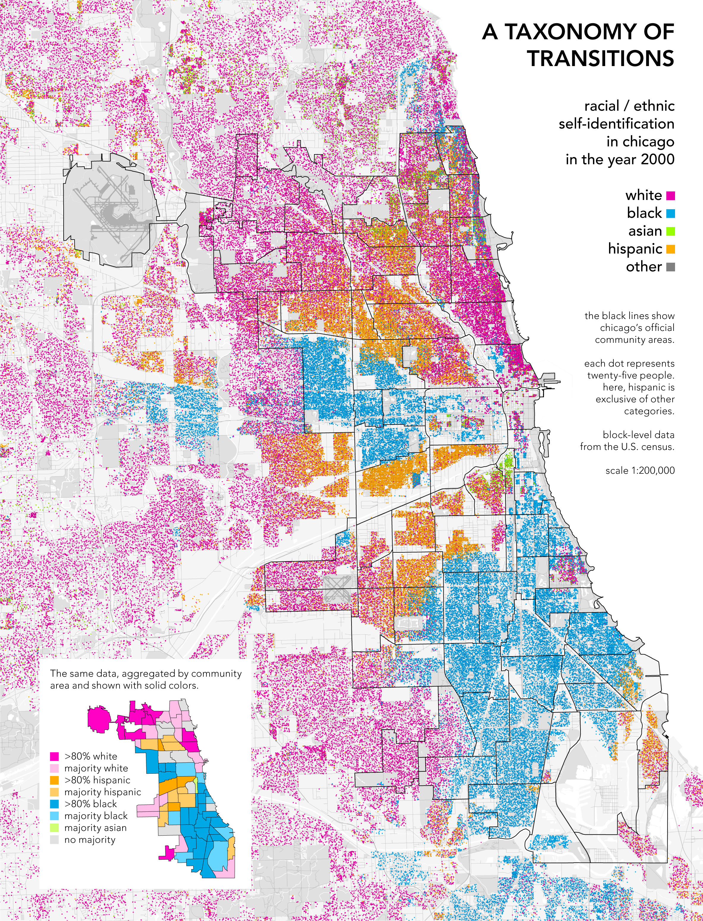
menino fucked around with this message at 19:40 on Feb 11, 2013 |
|
#
¿
Feb 11, 2013 19:38
|
|
|
Hello Towel posted:You're right that Hegewisch had a lot of white people until recently, but I'm talking about the bit I circled in red here. It's down on the very edge. I see. That's weird. I didn't know Whiting existed. My family is from South Holland/Hammond/Highland and I always assumed it was all Hammond next to Chicago. Whiting seems to be just that one cluster of houses between Indianapolis Blvd and the lake?
|
|
#
¿
Feb 11, 2013 20:10
|
|

|
I remember reading something about the pulling back of the Ming fleets resulting from a concern over increased nomadic activity on the north/western frontier. The gist of the article was that China was in a 200 year swing from land to naval power, however, so I'm sure the author was trying to pump up his argument a little bit. e: Just taking that at face value, it would support the geography is destiny argument. Less food in Siberia=less Zheng He=Pizzaro gets Mexico and not the Ming sorry Huangdi
|
|
#
¿
Feb 14, 2013 04:10
|
|
|
hotgreenpeas posted:Wait, public transportation maps count? Even just linking the Brown to the Blue at Belmont would be fantastic.
|
|
#
¿
Feb 14, 2013 14:03
|
|

 (Will never happen.)
|
Rhesus Pieces posted:Contrasted with: Diabeetus.jpg 
|
|
#
¿
Mar 23, 2013 18:17
|
|

|
3peat posted:I was curious why Romania would be dangerous so I went to the website, and it shows up as green to me for some reason? It's pretty easy to have good internal race relations when you just kill the ones you don't like. Romanians have about as much moral authority as Germans when it comes to racial politics. http://en.wikipedia.org/wiki/Ia%C8%99i_pogrom
|
|
#
¿
Apr 7, 2013 16:00
|
|

|
NewtGoongrich posted:It's pretty easy to have good internal race relations when you just kill the ones you don't like. Romanians have about as much moral authority as the Americans when it comes to racial politics. No argument here. Map: 
|
|
#
¿
Apr 7, 2013 20:10
|
|
|
Jerry Cotton posted:Well the distortion is kind of the point, it would just help a lot if the names of countries were on the map. Yeah I tried to find a labeled one but couldn't. It's not the best map, I admit.
|
|
#
¿
Apr 7, 2013 21:54
|
|
|
Soviet Commubot posted:Cornwall should be light blue because Cornish doesn't have indefinite articles. So does Bulgarian have some kind of sprachbund thing going on? Why is it the only Slavic language with articles?
|
|
#
¿
Apr 19, 2013 22:50
|
|

|
A fried of mine posted that Berlin pic too, saying that you could tell the east from space based on the chemical composition of its light bulbs, which for some reason hadn't changed since reunification.
|
|
#
¿
Apr 21, 2013 15:06
|
|
|
Gangs of Chicago Now:  And then: 
|
|
#
¿
Apr 22, 2013 18:37
|
|
|
Speaking of Iran:
|
|
#
¿
Apr 30, 2013 17:47
|
|
|
Cygni posted:Some of those def aren't US bases, like Seeb. It's probably US bases + general 'allied' airbases + airbases the US could theoretically use. Yeah I'm not sure exactly where it's from, I had it in my imgur account from a while back. A Google image search gave me an Al-Jazeera interactive map: http://www.aljazeera.com/indepth/interactive/2012/04/2012417131242767298.html But I think the original image was from Juan Cole's blog here As one commenter on Cole's blog states: Peter Leonard posted:I can�t speak to the accuracy of the map in Afghanistan and the Middle East, but almost all the bases supposedly in Central Asia are a figment of the mapmaker�s imagination. Mostly, they are bases that never existed, and one (in Uzbekistan) was shut down in 2005. I think the map on the AJ site is probably more accurate.
|
|
#
¿
May 1, 2013 01:39
|
|
|
eSports Chaebol posted:Chicago actually allows precincts to vote to ban liquor sales, and there are a bunch of dry ones. Sure you can buy alcohol on the South Side, as long as you're white! That line down Western is pretty ridiculous.
|
|
#
¿
Jun 11, 2013 07:48
|
|

|
prefect posted:"According to the Nebraska Liquor Control Commission, beer sales at Whiteclay's four liquor stores totalled 4.9 million cans in 2010 (~13,000 cans per day) for gross sales of $3 million." 13,000 cans a day, but there's only around 30,000 people on the reservation, according to wiki. Good lord.
|
|
#
¿
Jun 17, 2013 17:23
|
|
|
marktheando posted:How is it not? You mean the country with the preponderance of native speakers of a language creates definitions of words based on it's particular usage? That's shocking. Downright shocking. But what's this? A member of the Anglophone world hating on the US, apropos of nothing? Real loving shocking. Use determines meaning, and we are the ones doing the using. Here's a map: 
|
|
#
¿
Jun 18, 2013 23:32
|
|
|
Dusseldorf posted:It's always nice when someone throws out a bonafide Mercator projection just to make a map terrible for no reason. Also a whole lot of people (edit: 125 million) speak English in India. And China too. But they are not native speakers, they are English "users", which is a completely different category, mostly that they can handle the passive skills but falter with active ones. Mercators suck, but the numbers are the numbers.
|
|
#
¿
Jun 18, 2013 23:40
|
|
|
thekeeshman posted:Much as I would love to blame the British empire for pretty much everything, in this case it was Muslim separatists who demanded a separate country for Muslim populations, it wasn't the Brits' idea. They weren't immediately responsible, but the Partition of 1905 went a long way towards ensuring there'd be trouble a few decades later. 
|
|
#
¿
Jul 3, 2013 04:43
|
|
|
CellBlock posted:That's not the map title, Iceland uses patronymic names instead of surnames. Pretty sure that Hansen, Jensen, Andersson, and Joensen are also patronymics. I'd say title.
|
|
#
¿
Aug 27, 2013 02:04
|
|
|
R. Mute posted:I'm not sure. I basically always heard that it was a class divide turned into an ethnic divide thanks to Belgo-German pseudoscience. I do remember reading that the Hutus and Tutsis were originally the same ethnic group but one group herded while the other farmed, and that eventually there existed a small distinction that the colonizers took and exploited. Am I off on this? Did anyone else read this? I think it may have been a War Nerd column, and he tends to get over his head when he writes about Africa. E: Yeah it was a War Nerd article, which is behind a paywall here. The gist of it was that the Tutsis were the cattle herders who had come down from the lakes in the 1400's and were better fighters but couldn't overwhelm the numerically superior (because of agriculture) Hutus. His take was that Rwanda was one more iteration of the war between the two and that the UN stepping in has prolonged the misery. I don't where he's getting his research from though. Map: 
menino fucked around with this message at 22:46 on Aug 28, 2013 |
|
#
¿
Aug 28, 2013 22:36
|
|
|
Ardennes posted:Granted, without digging into the data it is hard to say what qualifies as different ethnicity in their eyes, since just because the US is only "medium grade" diverse doesn't make it not multi-ethnic nation. For example, German-Americans are 17.1% of the population which may be a plurality but doesn't seem nearly a overriding ethnicity. The US really doesn't have a single over-riding ethnicity period unless you just want random white people together. I think this is measured by # of speakers of other languages as a % of total population, just judging by how not diverse Brazil was classified as.
|
|
#
¿
Sep 5, 2013 13:53
|
|
|
 Source: http://www.tufts.edu/alumni/magazine/fall2013/features/up-in-arms.html
|
|
#
¿
Nov 7, 2013 15:43
|
|
|
Ofaloaf posted:They both theoretically speak French, except Louisiana doesn't do that much at all today, and they both speak strongly different dialects, not to mention the difference between Cajun French and Louisiana Creole alone. I don't get that at all. I would split that into Great Lakes and New England. They're similar but not really. Also I don't get why counties north of St. Louis are Appalachian but St. Louis isn't, or why Midlands is the way it is. St. Louis isn't anything like Phillie.
|
|
#
¿
Nov 7, 2013 16:05
|
|
|
A Buttery Pastry posted:What I'm getting from this thread is that my map of a balkanized US + Canada is superior to this one. I like how completely (and justifiably) everybody tore apart that crappy map after I posted it, and how many times I've seen it on facebook with reverential commentary since then. We truly are the gold standard of parsing lovely maps from less lovely maps.
|
|
#
¿
Nov 14, 2013 05:16
|
|
|
withak posted:Not politically-loaded, but related to the cool map above. From Stratfor, so take with a grain of salt 
|
|
#
¿
Dec 14, 2013 02:12
|
|

|
Grand Fromage posted:One of my friends in college was a Serb from Croatia, and you're correct. Croatian and Serbian are the same language; she compared it to British and American English. You know where someone is from because of certain words that are different, but otherwise they're entirely mutually intelligible. They're only called different languages because of politics and the issues between the Serbs and Croats. Serbian is written in Cyrillic while Croatian is Latin though right? Could a Croatian read Serbian? 
|
|
#
¿
Dec 30, 2013 11:57
|
|
|
Deltasquid posted:"Cyrillic is the official script of the administration in Serbia and Republika Srpska but Latin script is most widely used in everyday life." I wonder what kind of situation that creates for Serbs. It seems like you'd get a lot of people who are out of practice with the official script, unless it's the script of instruction too.
|
|
#
¿
Dec 30, 2013 12:07
|
|
|
Deltasquid posted:Hahahaha how do you even get away with poo poo like this? Imagine the shitstorm if a globe in a French classroom had a sticker on Europe that makes France twice the size of Germany and the UK. Korea loves to do this kind of crap. I remember a few years ago some school kids drew anthropomorphic maps of the two countries, one of which actually included a fanged South Korea chewing on Japan's balls. It was displayed in a major Seoul subway station. I am trying to find the link. E: Here we go: http://www.geocities.jp/bxninjin2004/data_room/05/cache/02/index.php.htm gently caress you, 일본  Balls: 
menino fucked around with this message at 18:12 on Apr 20, 2014 |
|
#
¿
Apr 20, 2014 18:06
|
|
|
TildeATH posted:I don't understand this one. And to be clear, I really want to understand it. My Korean is real basic, but the first line "Japanese People!" and the second is literally translated as "deter, don't write 3" which makes no sense to me but might be some kind of phonetic/image slang for "3"? And yeah the drawing looks like the finger.
|
|
#
¿
Apr 20, 2014 19:49
|
|
|
Modern Day Hercules posted:A unified Korea would not rival Japan. Korea has never not played third fiddle to Japan for as long as there has been a japan. Even if both Koreas had the GDP of South Korea, and then there were 2 more Koreas on top with the same, it wouldn't match Japan. It's not going to be any sort of credible threat to Japan. Your first point is pretty much the entire picture. They already don't like dealing with the refugees from the "good" Korea, can't imagine they'd like the idea of tens of millions of starving rear end north koreans running wild in the area. How many refugees from South Korea are in Japan? I'd imagine you can count them on one hand. Unless you are classifying the Zainichi as refugees.
|
|
#
¿
Apr 21, 2014 13:14
|
|
|
The Monkey Man posted:I remember the South Korean government buying full-page ads in the New York Times after one of their articles referred to the "Sea of Japan" and complaining about it. I love how the Koreans insist on both the Yellow and Japan as "West Sea" and "East Sea" respectively. Good idea getting people on your side by insisting on having your particular geographic orientation as the determining factor.
|
|
#
¿
Apr 21, 2014 15:14
|
|
|
Grand Fromage posted:East China Sea is also the South Sea. South Sea is very famous.
|
|
#
¿
Apr 21, 2014 15:27
|
|
|
TildeATH posted:All this kvetching over that map is silly. The purpose of the map was to show one climate region, and it did that. I doubt that any of you saw it and said, "Wait, without Greenland, or the Kurils, I can't make out where things are in this representation of the world." Maps are made to relay information, and often times the incredible complexity of the coastlines of the Earth, and even the presence of certain major (often ice-covered) land masses are not that purpose. Seriously, this was a map about a very limited biome, no poo poo they're not going to have the Azores in full resplendent detail. E: Haha I'm an idiot, the one obscure island chain I mention actually has a Mediterranean climate.
|
|
#
¿
Apr 23, 2014 15:18
|
|
|
DrSunshine posted:Fine, fine! Here!! WHERE ARE THE AZORES
|
|
#
¿
Apr 23, 2014 15:45
|
|


|
Grand Fromage posted:China has Mediterranean climate because the Mediterranean is an integral part of China for 5000 years. The Mediterranean climate has four seasons. It was invented in China/Korea/Japan.
|
|
#
¿
Apr 24, 2014 06:34
|
|
|
Shbobdb posted:Phone posting, it should have read: I have a photo of the Mediterranean climate at the Yasukuni shrine. This may explain it's absence from China. The Mediterranean climate has, time and time again, hurt the feelings of the Chinese people.
|
|
#
¿
Apr 24, 2014 17:14
|
|
|
Dusseldorf posted:I feel like Illinois has a singular problem that no one in Chicago likes the state and no one in the state likes Chicago. I don't think any other state is quite as bent that way. This is pretty much it right here. I mean Chicago is corrupt, but so is the rest of Illinois. You just get so much pious  once you start getting south of that Cubs/Cardinals line. And of course your public Chicago figures are guys like Rahm Blago and Daley, so the hell wouldn't dislike Chicago either? I'm a native south sider, going to Sox games infuriates me with all the stupidity. Turning on the Score instantly raises my blood pressure. It's a perfect storm of fuckitude. once you start getting south of that Cubs/Cardinals line. And of course your public Chicago figures are guys like Rahm Blago and Daley, so the hell wouldn't dislike Chicago either? I'm a native south sider, going to Sox games infuriates me with all the stupidity. Turning on the Score instantly raises my blood pressure. It's a perfect storm of fuckitude.Regardless Chicago is the greatest city on Earth, Go Sox Go Daley Go Fuckyourself
|
|
#
¿
May 1, 2014 23:41
|
|
|
Pakled posted:The Kangnido: a 1402 Korean world map. Korea is #1!!!!! Dokdo forever! 
|
|
#
¿
Mar 5, 2016 16:32
|
|


|

|
| # ¿ May 4, 2024 16:02 |
|
|
doverhog posted:Didn't even reach Ireland. Rubbish empire. They would have but the Japanese did something evil E: But they got theirs! 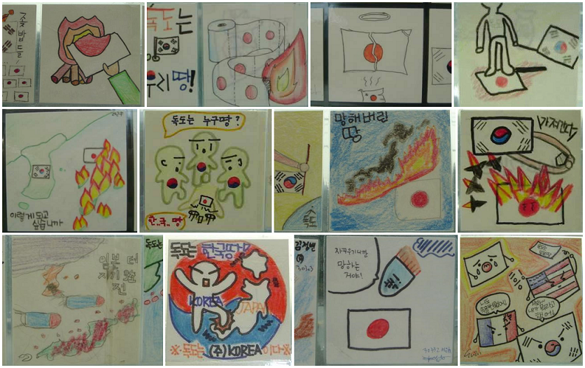
|
|
#
¿
Mar 5, 2016 16:42
|
|