


|
My understanding is that even in the most desolate parts of the continent there were occasional bands of huntsmen who left their home area to search for food, and that therefore every part of the country can be (roughly) connected to a specific language or dialect that was at least prevalent amongst those who traveled that area. But yeah, the map isn't super precise and doesn't claim to be, and it's questionable if a really precise map of pre-contact linguistic groups could ever be made, anyway. Re: aboriginal population distribution, I didn't find a map specifically concerned with that, but maybe this map of archaeological finds of the Pleistocene (50,000-10,000 years ago) and the Holocene (from 10,000 years ago until the present). I got it from this paper where there's a couple of other maps, too.  As one can see, virtually all of recorded human activity pre-contact was to be found along the coast along with that "belt" stretching from what is today Melbourne in the south to Alice Springs in the north-west. That doesn't necessarily mean that this perfectly mirrors actual population patterns of that time, however; it could just be that we're lacking archaeological data from those desert areas where digs would be a pretty uncomfortable affair, even if we might find stuff there. We also know that population distribution varied over time; during the last ice age, for example, it is estimated that human settlement only covered a very small part of the continent:  Many of the languages spoken by Aborigines didn't survive the last 250 years or so, and so there are many languages where we know hardly more than that they were spoken at some point (out of the at least 250 languages spoken pre-contact, no more than 90 remain, and most of them are only spoken by a handful elders and will die out soon). I can't really say anything about mutual intelligibility, but we can at least say that the extant data we have suggests a linguistic two-part division of the continent: the Pama-Nyungan language family covering its largest part, and an absolute fuckton of tiny language groups and families along the northern shore.  The large yellow blob is Pama-Nyungan. The light green and orange areas to its north are the Garawan, Tangkic and Macro-Gunwinyguan languages, respectively, which may be related to Pama-Nyungan. The others are various unrelated language families; in some cases the coloured areas even refer to multiple language families that form a macrofamily of their own. So, without knowing too much about it I'd guess that at least along the Pama-Nyungan it might have been possible to maintain at least a certain degree of mutual intelligibility even over comparatively large distances, whereas the sheer linguistic variety of northern Australia might have made communication more difficult between various peoples. Regardless, it is commonly stated that all Aboriginal languages form a "Sprachbund", i.e. share many common features and even vocabulary. I also remember reading somewhere that for many Aboriginal Australians it was or even is usual to grow up speaking not one, but many languages, i.e. the native language in addition to those of neighbouring nations or even "linguae francae" spoken by traders over large areas.
|
 #
?
Feb 27, 2018 15:33
#
?
Feb 27, 2018 15:33
|
|


|

|
| # ? Jun 8, 2024 06:56 |
|
|
Saladman posted:(E: and if you think that's a ethnocentric / language-centric thing to say, then you've obviously never had a cat walk across your keyboard.) It's ethnocentric to compare a foreign language to gibberish. The cat is not guilty of anything.
|
|
#
?
Feb 27, 2018 16:46
|
|

|
Whiz Palace posted:It's ethnocentric to compare a foreign language to gibberish. The cat is not guilty of anything. I'm impressed that he even knows what "Murrinh Nangikurrnunggurr" sounds like.
|
|
#
?
Feb 27, 2018 16:48
|
|

|
Whiz Palace posted:It's ethnocentric to compare a foreign language to gibberish. The cat is not guilty of anything. Unless the language in question is welsh
|
|
#
?
Feb 27, 2018 17:20
|
|

|
Lllywcclymwcccllycwyyl
|
|
#
?
Feb 27, 2018 21:03
|
|


|
^^^ Yeah, I guess basically any language with a lot of digraphs / double letters looks like what happens when a cat walks across a keyboard. System Metternich posted:My understanding is that even in the most desolate parts of the continent there were occasional bands of huntsmen who left their home area to search for food, and that therefore every part of the country can be (roughly) connected to a specific language or dialect that was at least prevalent amongst those who traveled that area. But yeah, the map isn't super precise and doesn't claim to be, and it's questionable if a really precise map of pre-contact linguistic groups could ever be made, anyway. Well that was an amazing post. I had already spent like 20 minutes reading about it before but found nowhere close to as much info as you posted. Thanks!
|
|
#
?
Feb 27, 2018 21:29
|
|
|
System Metternich is a knowledge-dispensing machine, he puts all us other nerds to shame
|
|
#
?
Feb 28, 2018 00:06
|
|


|
What makes the distribution of languages even more interest is that mutual intelligibility isn't based on geographical proximity, but rather on migration and trade routes. This in itself isn't unusual, but what makes it really cool is that to look at the majority of Australia from the outside all you really see is a featureless desert. Aboriginal Australians therefore knew routes of travel through songlines, which sometimes covered hundreds or even thousands of kilometres. The songlines allowed for navigation passed down orally with reference to stars and landmarks. So Arrende - a central Australian desert mob language, spoken by the people of the Alice Springs area - has more in common with Worimi (spoken in what's now Newcastle, on the central east coast) and Yawuru (spoken in what's now Broome on the north west coast) than it does with other southern NT tribes, because people travelled along that path across the desert, following the same songline over thousands of years. What's also cool is that some of those songlines live on today, even when nations along that line were displaced or genocided, because the surveyors for Australia's road system relied (by necessity) on Aboriginal trackers to show them safe ways across the expanse of desert, and those people were following songlines. It's only recently, with more understanding of both Aboriginal culture and astronomy, that people are realising that Australian highways almost all follow a path marked in the stars. https://www.sbs.com.au/topics/life/culture/article/2016/04/11/how-ancient-aboriginal-star-maps-have-shaped-australias-highway-network 
|
|
#
?
Feb 28, 2018 02:30
|
|

|
https://twitter.com/mrejfox/status/968200473655283712
|
|
#
?
Feb 28, 2018 03:03
|
|

|
Saladman posted:drat that is a lot of Aboriginal languages. It'd be cool if they colored them based on mutual intelligibility, but that probably requires more knowledge about the languages than almost anyone has. A lot of those were likely small and isolated populations even before colonization. The Australian west didn't really offer an environment conducive to the formation of large states, but you don't really need more than a few thousand people to form and sustain a distinct nation, especially when there are serious geographic/lifestyle barriers to communicating and assimilating with your neighbors. New Guinea, Central Africa, and pre- Spanish California maintained incredible levels of linguistic diversity for the same reason.
|
|
#
?
Feb 28, 2018 03:44
|
|
|
Divorced And Curious posted:What's also cool is that some of those songlines live on today, even when nations along that line were displaced or genocided, because the surveyors for Australia's road system relied (by necessity) on Aboriginal trackers to show them safe ways across the expanse of desert, and those people were following songlines. It's only recently, with more understanding of both Aboriginal culture and astronomy, that people are realising that Australian highways almost all follow a path marked in the stars. Isn�t this a bit like �the size of the Space Shuttle�s solid rocket motors was determined by the spacing of Roman chariot wheels�? The best routes are the best routes. You could drop space aliens or slime mould onto the continent and they would eventually come up with very similar solutions.  e: This could come across as dismissive of Aboriginal achievements, which is not my intent. Blazing trails across the Australian interior is an incredible feat that took skill, courage, and stamina. What I am saying is that they found good routes. Those routes were refined till they were essentially optimal. And there is only one set of optimal routes for a given set of constraints. Platystemon fucked around with this message at 08:06 on Feb 28, 2018 |
|
#
?
Feb 28, 2018 07:31
|
|

|
Duckbox posted:A lot of those were likely small and isolated populations even before colonization. The Australian west didn't really offer an environment conducive to the formation of large states... quote:Western Australia is Australia's largest state, with a total land area of 2,529,875 square kilometres (976,790 sq mi), and the second-largest country subdivision in the world, surpassed only by Russia's Sakha Republic  I think I understand what you mean though. There is literally nothing in large parts of the state except sand and salt-bush. It's well over a third of continent, yet with about 2.6 million inhabitants has around 11% of the national total. Platystemon posted:Isn’t this a bit like “the size of the Space Shuttle’s solid rocket motors was determined by the spacing of Roman chariot wheels”? Cable Guy fucked around with this message at 08:10 on Feb 28, 2018 |
|
#
?
Feb 28, 2018 08:07
|
|


|
Cable Guy posted:Not really. That might be true if the routes had been solely forged because of land-forms and expediency. The article is suggesting that the routes may have been planned to reflect constellation patterns in night sky. Aren�t the star patterns an aid to learning and memory? First they found the routes, then they sought asterisms that pretty closely matched them.
|
|
#
?
Feb 28, 2018 08:14
|
|
|
While we�re on the subject of ingenious indigenous navigation aids: Marshall Islands stick charts, rebbelib. The coolest thing about these is that they map the terrain of the ocean�persistent wave patterns. They didn�t just draw a sea monster and a compass rose and expect sailors to work it out by dead reckoning.
|
|
#
?
Feb 28, 2018 08:26
|
|
|
Platystemon posted:Aren�t the star patterns an aid to learning and memory?
|
|
#
?
Feb 28, 2018 08:28
|
|
|
Cable Guy posted:Gah... missed that. Well it still might be the case that �these routes made sense under the constraints Aborigines were working with. Different routes would have been superior for European colonists with their livestock and whatnot, but they used suboptimal routes because they were cribbing from the natives�. But I�d want to see that demonstrated. Like, if the Cumberland Valley were settled today, it probably wouldn�t have six towns, each fifteen kilometres apart, but before mechanised transport it made sense. 
Platystemon fucked around with this message at 08:55 on Feb 28, 2018 |
|
#
?
Feb 28, 2018 08:45
|
|
|
Cable Guy posted:Not sure you meant that quite the way it was written. WA is pretty darn big.
|
|
#
?
Feb 28, 2018 09:13
|
|


|
Phlegmish posted:System Metternich is a knowledge-dispensing machine, he puts all us other nerds to shame Aw you  This is *extremely* rad 
|
|
#
?
Feb 28, 2018 09:18
|
|
|
This week on 'I found it on Reddit':
|
|
#
?
Feb 28, 2018 12:05
|
|
|
The metaphor falls apart because I can't think of a TV series that was rebooted as many times as Poland.
|
|
#
?
Feb 28, 2018 14:52
|
|
|
Star Trek
|
|
#
?
Feb 28, 2018 15:00
|
|

|
That's a lot of human misery to be making some not even funny jokes about.
|
|
#
?
Feb 28, 2018 18:51
|
|

|
I don't think Start Trek V was that bad.
|
|
#
?
Feb 28, 2018 19:16
|
|


|
Teriyaki Hairpiece posted:That's a lot of human misery to be making some not even funny jokes about. Don't be so uptight, it was made by a Polish person.
|
|
#
?
Feb 28, 2018 23:00
|
|
|
khwarezm posted:Don't be so uptight, it was made by a Polish person. Well the Poles got out of it barely scathed, what with participating in the holocaust and that
|
|
#
?
Feb 28, 2018 23:10
|
|

|
Ras Het posted:Well the Poles got out of it barely scathed, what with participating in the holocaust and that Your insinuation is ILLEGAL !!!
|
|
#
?
Feb 28, 2018 23:46
|
|


|
Ras Het posted:Well the Poles got out of it barely scathed, what with participating in the holocaust and that Right, well I'll get in touch with the guy who made the meme and tell him he didn't grapple with the gravity of Polish involvement in the Holocaust well enough in his made for facebook joke posts.
|
|
#
?
Mar 1, 2018 00:05
|
|
|
khwarezm posted:Right, well I'll get in touch with the guy who made the meme and tell him he didn't grapple with the gravity of Polish involvement in the Holocaust well enough in his made for facebook joke posts. I was making a something awful forums joke post as the guy above you noticed
|
|
#
?
Mar 1, 2018 00:09
|
|
|
Teriyaki Hairpiece posted:That's a lot of human misery to be making some not even funny jokes about. Human misery is the root of all comedy
|
|
#
?
Mar 1, 2018 02:45
|
|

|

|
|
#
?
Mar 1, 2018 07:01
|
|

|
Poland, the place with the worst casualty figures of any country, got out of WWII unscathed. You learn something every day. (Yes, I know those figure include Holocaust victims, but those do not account for the remaining 60% of Pol. war deaths)
steinrokkan fucked around with this message at 09:32 on Mar 1, 2018 |
|
#
?
Mar 1, 2018 09:23
|
|

|
I'm the Western Slabs of Extremadura...
|
|
#
?
Mar 1, 2018 09:30
|
|
|
A Buttery Pastry posted:State has multiple meanings, in this case sovereign, not sub-region. Yeah, this. I'm an American, so I should be used to state=province, but that's not what it means in poli-sci terms. Incidentally, the US was originally a union of 13 independent countries so that use of the word "state" was appropriate at first. Supposedly, before the Civil War, the United States was a plural as in "the United States are" and afterward it became a singular -- "the United States is." At least that's what Ken Burns taught me. Idk what excuse Mexico, Australia, etc. have though.
|
|
#
?
Mar 1, 2018 09:31
|
|
|
Duckbox posted:Yeah, this. I'm an American, so I should be used to state=province, but that's not what it means in poli-sci terms. It's still plural in German and French ("Die Vereinigten Staaten" and "Les �tats-Unis", respectively) and possibly in other languages too.
|
|
#
?
Mar 1, 2018 10:07
|
|
|
Yeah it's plural in Spanish too, but possibly in British English as well? Like in British English collective nouns are considered plurals for verb agreement, like in British it's "Congress are passing a law" whereas in US it's "Congress is", etc. Also in Spanish the abbreviation for the US is "EEUU" which always throws me for a spin when I see it and forget that for some reason Spanish doubles the letters on abbreviated plurals.
|
|
#
?
Mar 1, 2018 10:51
|
|
|
Still plural in Dutch as well (Verenigde Staten). I'm not sure about Australia, but I think Mexico is a similar story to the USA where a group of colonial entities which were distinct from each other joined into one country after their independence from Spain. However, the word "state" is used quite often for sub-national entities as well, outside of that. Germany is composed of Lander, which means "countries" unless the word is a false friend in Dutch, and Belgium itself is composed of "deelstaten" (part-states). Federal and confederal countries often refer to their sub-federal entities as "states", regardless of whether they were ever actually independent in their present shape or form. 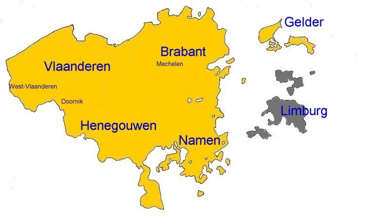  Pictured: the United States of Belgium, which existed from January 1790 to December 1790. In Dutch they called themselves the Verenigde Nederlandse Staten and in French the �tats-Belgiques-Unis. I think the word "state" might be derived from "estate", as in, "the estates-general" of a country. In Dutch at least, State and Estate are used in the same way, which would explain why sub-national entities can still be called states. Poli-sci probably just uses "states" to refer to the national level out of convenience and to prevent confusion, but historically, lots of things were called states even if they weren't entirely sovereign.
|
|
#
?
Mar 1, 2018 11:04
|
|


|
The states and territories of Australia were independent colonies before hand and their Federal constitution to this day grants them quite a lot of power, similar to US states.
|
|
#
?
Mar 1, 2018 13:19
|
|

|
Incidentally we also say �the united nations is� in american english nowadays.
|
|
#
?
Mar 1, 2018 13:45
|
|
|
Edgar Allen Ho posted:Incidentally we also say “the united nations is” in american english nowadays. Oh no Agenda 21 is winning  
|
|
#
?
Mar 1, 2018 13:55
|
|


|

|
| # ? Jun 8, 2024 06:56 |
|
|
Some of the cantons of Switzerland are / were also called states because they used to be states. One I know from the top of my head is "la R�publique et Canton de Neuch�tel" = The Republic and Canton of Neuch�tel. This used to be Prussian, was allowed to join the Swiss confederacy as a monarchy (the only one), revolted to a republic in 1848 and then remained when we went to a federation in the same year. Also Switzerland as a whole used to be made up out of states, I can remember a book called "Vom Staatenbund zum Bundesstaat" (From confederation to federation). But the situation during the HRE was complicated anyway concerning statehood.
|
|
#
?
Mar 1, 2018 15:24
|
|
