


|
Budzilla posted:This should have been posted in the OP. PNAC redrawing of the ME. Was this map used seriously somewhere? The whole thing looks like a joke. "Afghanistan needs to be bigger, guys"
|
 #
¿
Oct 18, 2013 02:56
#
¿
Oct 18, 2013 02:56
|
|


|

|
| # ¿ May 13, 2024 02:25 |
|
|
KoldPT posted:
Is this map available in other regions, or at different resolutions? I like population density maps but the resolution on this one makes it extremely informative.
|
|
#
¿
Oct 30, 2013 16:08
|
|

|
The BBC has an article about border-drawing in the Middle East, from the Sykes-Picot agreement. Some maps:  You see an international zone around Israel/Palestine. The article doesn't mention this, but the major powers on both sides of WW1 were trying to please zionists by promising them a homeland (along with promising independence for the arabs). While there is a lot to talk about there, my questions is is anyone knows why the site of old Antioch is also in the international zone.
|
|
#
¿
Dec 14, 2013 18:19
|
|
|
Man Russia has a gently caress-ton of permafrost, jesus. Speaking about the border of Russia and China, I find it neat how virtually their entire shared border follows the path of a river/series of rivers. Makes a handy border, and was something I found just by closely looking at maps once. And while I was looking at said rivers, I noticed that there was a Russian province called the "Jewish Autonomous Oblast", which borders China. Here is an amusing image which shows the location as well as the coat of arms and (rainbow) flag of the province: 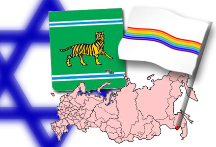 Turns out there is an interesting Jewish history in Manchuria as well, though I haven't looked into the details there.
|
|
#
¿
Dec 16, 2013 03:41
|
|
|
Whorelord posted:
I know I've seen really different numbers for this. Several years ago I thought the numbers were a few Caribbean nations at the top. After some googling I can't find anything so maybe I'm full of poo poo. But I have a really hard time believing that a higher percentage of the US population smokes pot than Canada or freaking Jamacia.
|
|
#
¿
Dec 21, 2013 16:45
|
|

|
computer parts posted:Vegas mostly, it seems. Very neat.
|
|
#
¿
Dec 23, 2013 17:40
|
|

|
Neat, but why are the borders so strange? Is this broken up by county?
|
|
#
¿
Jan 10, 2014 23:04
|
|
|
Grand Fromage posted:A pretty nasty one too. Other than the minerals and prestige, another reason China would never give it up is just about every major river in China comes from glaciers in Tibet. China has enough water problems without giving control over its fresh water supply to an independent state that could decide to cut them off. Was going to say this. The sources of rivers are very important, and are only going to become more so in the future.
|
|
#
¿
Jan 12, 2014 16:28
|
|
|
Koramei posted:Almost certainly yes to all of those, but keep in mind that that map was probably not written with any regards to religious sensitivity. drat, I didn't know Taiwan was part of the Japanese conquests along with Korea.
|
|
#
¿
Jan 15, 2014 16:17
|
|
 )
)
|
I don't think this has been posted, though individual maps have been. There are some good ones in here: http://www.washingtonpost.com/blogs/worldviews/wp/2014/01/13/40-more-maps-that-explain-the-world/ Airline travel, for one day:  
Count Roland fucked around with this message at 22:11 on Jan 16, 2014 |
|
#
¿
Jan 16, 2014 22:09
|
|
|
What is logical about the prime meridian running through Greenwich? That its opposite side goes basically clear through the Pacific? Actually reading on wiki I bet this is your reasoning, because it is along the International Date Line that you add or subtract an entire day, to keep in time with the rest of the world. Having this line run through inhabited territory (aside from small islands) would be cumbersome. Is that right?
|
|
#
¿
Jan 17, 2014 21:05
|
|
|
I found it hilarious how basically every country in Europe had their own nationality as the top search. Except for Ireland, which went: 1) Gangbang 2) Drunk 3) Irish I also had no idea that "casting" was a fetish/BDSM thing. It was a top result all over the place. edit: and whats up with the top corner, where you can choose between "Straight", "Gay" and "Tranny". I was on the US, and clicked Gay, and the top result was "Straight". The gently caress?
|
|
#
¿
Jan 19, 2014 01:37
|
|
|
made of bees posted:That could be why some Estonians want to do exactly that. I've stumbled on this before and I've got to say the Nordic version looks way better.
|
|
#
¿
Jan 21, 2014 01:30
|
|
|
Lord Hydronium posted:The size of Alaska: Sweet jesus. I just looked up the area on wiki, and indeed Alaska is bigger than the next 3 states combined (Texas, California, Montana). I did not realize the difference was so large.
|
|
#
¿
Jan 29, 2014 15:23
|
|

|
Torrannor posted:Well, in the oft-maligned Mercator Projection, Alaska is about half as big as the entire contiguous United States. Yeah, I knew it was big, I just figured it was a trick of the projection. Nope! This is why I need a globe.
|
|
#
¿
Jan 29, 2014 17:09
|
|
|
Peanut President posted:Folks asking me to define worth: Can't farm it, it's nearly inhospitable, and it's really hard to get to. It's like buying the moon. Laying claim to mineral or hydrocarbon reserves is useful, and it gives the US significant claims to arctic territory. Considering how the arctic has been warming and become more open to shipping, this is pretty darn useful. It is a long term investment for sure, but it absolutely has worth.
|
|
#
¿
Jan 29, 2014 18:47
|
|
|
chairface posted:It was strategically useful in WWII. A lot of lend-lease gear was sent through Alaska and then Siberia to the USSR from the USA. There's sadly not an accompanying map but http://en.wikipedia.org/wiki/Arctic_convoys_of_World_War_II A huge road was built to Alaska as well. I guess it included or connected to one in Canada, but I feel the entire thing was made at once. I saw a doc on it over a decade ago, it was interesting to see how the army built a highway through mountainous terrain at such an absurd and consistent pace. The US at the time was concerned of a Japanese attack on Alaska, and wanted to be able to defend it via ground as well. Lawman 0 posted:Unironically we should start thinking about how to split up the moon and asteroids soonish. Yes. Since nations have stated plans to build at least semi-permanent bases on the moon, we should likely start thinking about this.
|
|
#
¿
Jan 29, 2014 21:42
|
|
|
computer parts posted:Even if we get bases up and running it's still not going to be any easier to do moon stuff than Antarctic stuff and that continent is still considered neutral ground. Yeah I was going to bring this up too. There is a continent worth of stuff, including a gently caress-ton of water, that nobody is exploiting. This is fine for now, but in 50 or 100 years when other resources have been depleted, well, I pristine Antarctica will be the new frontier. This was featured in the Red Mars series of books. The same Trans-National corporations that were taking over Mars and Space were mining Antarctica because nobody felt like defending the treaties. Neat stuff.
|
|
#
¿
Jan 29, 2014 22:03
|
|
|
Video games: bringing out the inhuman monster in all of us.
|
|
#
¿
Jan 30, 2014 20:04
|
|
|
Shouldn't forums more generally be bigger? Aren't they important too? I like them.
|
|
#
¿
Feb 1, 2014 03:51
|
|
|
Real hurthling! posted:but twitter is like one big forum where people use their real names and censor their racist opinions even less! Twitter has its uses, but lengthy, reasoned (or just lengthy) discussions are not among them. BBS4LYFE
|
|
#
¿
Feb 1, 2014 05:33
|
|
|
A Buttery Pastry posted:Though being shat on by Europeans up-close and personal wasn't/isn't exactly unheard of for Africans either. On the inset at the bottom left, Eretria isn't shown at all from '56 onwards. That bugs me.
|
|
#
¿
Feb 3, 2014 20:40
|
|

|
I'll say, very well put together. I didn't realize just how high immigration from Mexico has been. I mean, I know there are many millions, but graphs and firm numbers just make it so much clearer!
|
|
#
¿
Feb 4, 2014 16:45
|
|
|
re: coup map Libya should really be the darkest colour. They're almost in the middle of a slow moving coup as it is.
|
|
#
¿
Feb 24, 2014 19:47
|
|
|
I think one of these is a re-post. (cross posted from the Ukraine thread)  http://www.washingtonpost.com/blogs/worldviews/wp/2013/12/09/this-one-map-helps-explain-ukraines-protests/  http://en.wikipedia.org/wiki/History_of_Ukraine  http://www.washingtonpost.com/blogs/worldviews/wp/2014/01/24/this-is-the-one-map-you-need-to-understand-ukraines-crisis/
|
|
#
¿
Mar 1, 2014 04:34
|
|
|
A Buttery Pastry posted:Not at all. Currently, Africa sits on top of an upwelling of mantle, which is why the continent is relatively uniformly high-elevation in the south, while Indonesia is just the opposite. Then there's accretion, which adds to to continents' edges, volcanic activity where plates are subducted, and finally orogeny where plates smash into each other. On top of that you have erosion, which can wither away at the continents quite rapidly, though this is very dependent on location/climate. Off topic, but could you tell me more about his "upwelling of mantle"? That results in different features on the face of the planet. Geology on this scale has often been interesting to me, but I don't even know what the field is called. I'd like to know more. Back to maps: Yup, this is very close to a map of the muslim world. Asia somewhat less, and Africa includes majority christian areas as well. Indonesia is a huge exception, and Turkey too. Little Jordan as well. The map is too lovely to see Lebanon or Bahrain or Qatar. And Kazakhstan only sorta maybe? borders Russia.
|
|
#
¿
Mar 5, 2014 01:35
|
|

|
made of bees posted:I feel like any metric that says LGBT rights are more or less the same in all of the US as in, say, the Netherlands is broad enough to be basically worthless. Blue might as well be one color, which means "not in jail". Yeah some finer details would be nice, I bet wikipedia has some. Yup:  Legend: http://en.wikipedia.org/wiki/Template:World_homosexuality_laws_map Source article: http://en.wikipedia.org/wiki/Legality_of_homosexuality Ooh, this map is good too, it is called "Decriminalizing Homosexuality":  Oh man this is actually great. It notes that France legalized homosexuality for a brief time during the revolution. Abortion was legalized too. Count Roland fucked around with this message at 02:16 on Mar 5, 2014 |
|
#
¿
Mar 5, 2014 02:07
|
|
|
PittTheElder posted:I'm curious about Brazil, and probably other countries in the same boat I didn't bother to look hard enough at: did they take actual steps to legalize homosexuality between 1800 and 1870, or was it just never illegal in the first place, and the map is counting from date of independence? It isn't legalize, its decriminalize. So remember that laws against homosexuality can fall into other categories. I see Canada is on there in the 60s. Homosexuality was only legalized there within the past decade or so. But they did introduce various laws against discrimination around that time. I don't know if they even mention the gays specifically, but I bet that's why Canada is on the list. I wonder why Turkey is on the list. In the 19th century Turkey started treating different religious groups a lot more equally (christians and jews had typically gotten special taxes and stuff). But Homosexuality? **shrug** Pastry, thanks for the description. Could you point me in the direction of a relevant article or book or wiki? Count Roland fucked around with this message at 02:36 on Mar 5, 2014 |
|
#
¿
Mar 5, 2014 02:28
|
|
|
pig slut lisa posted:That's gotta be at least a little wrong. The Nile floodplain is the most densely populated part of the country by far, it's true, but it thins out the farther upstream you go. Also the Fayoum Oasis isn't shown. I just looked at google maps. The difference is not as large as I would have thought. The delta region is densely populated, but still has a lot of farmland. Zoom in on any part of the Nile flood plain and you'll see both farmland a slew of towns. 200 people per square km? Uhhh, it looks like it'd be close, but it might actually be believable. Egypt does have 80 million people, after all, and they're almost all on the Nile.
|
|
#
¿
Mar 5, 2014 21:38
|
|
|
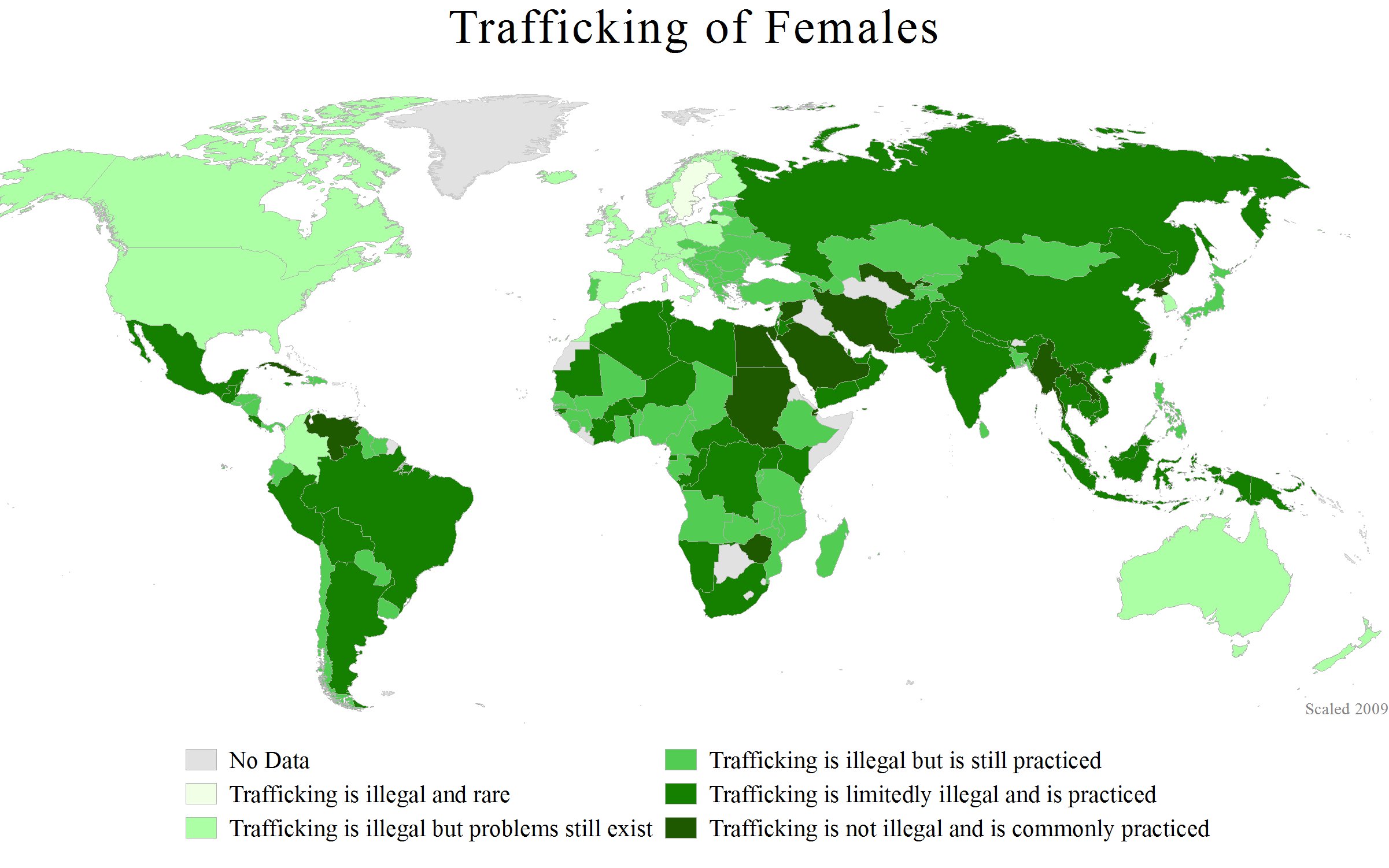
Kamrat posted:Since it's International Women's Day (or was yesterday depending on where you live) I thought I'd share some maps about the treatment of women in different countries. You won't break any laws by trafficking women in Iran? I find that difficult to believe. Also: the Caspain Sea isn't a good place for women, either.
|
|
#
¿
Mar 9, 2014 15:29
|
|

|
A Buttery Pastry posted:Salinity in the Baltic is only a fourth of what it is in the North Sea around the Danish islands, and it drops to less than a tenth in the furthest reaches, due to a high level of precipitation vs. narrow and extremely shallow straits. Conversely, the Mediterranean is very saline, especially in the east, since it has a high level of evaporation and a constant inflow from the Atlantic. Huh, neat. I wonder if there is a map of this? fake edit: yup 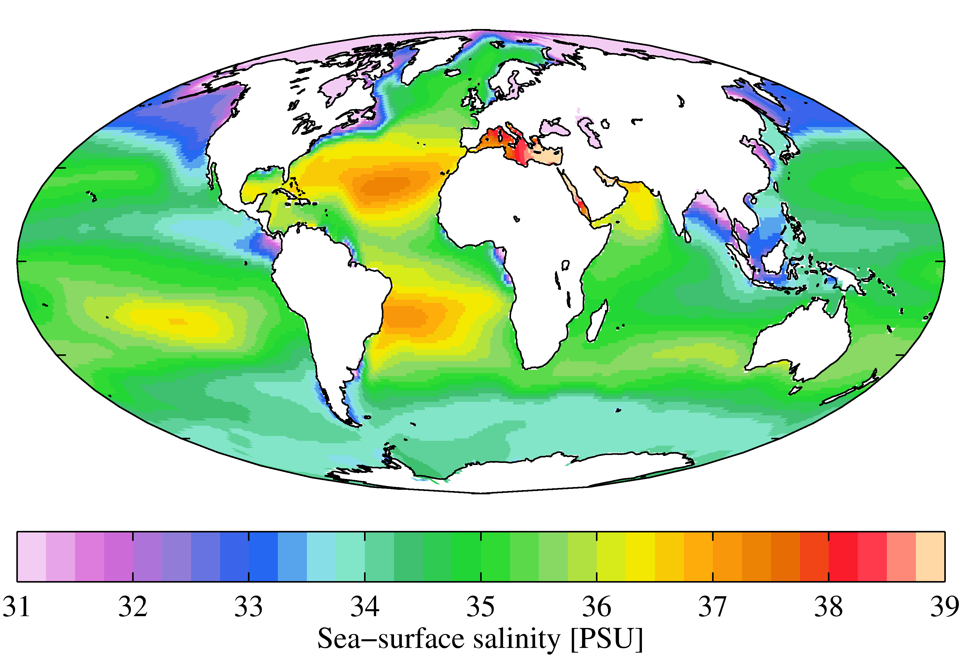
|
|
#
¿
Mar 11, 2014 03:22
|
|
|
I guess all the indigenous americans just, you know, left. If only 30 000 were killed, all those other millions must have just gone someplace else. Nobody's fault really.
|
|
#
¿
Mar 14, 2014 03:04
|
|
|
Phlegmish posted:All of these non-European civilizations sound like nancy boys to me. No wonder the Europeans won. This post got me wondering: do any major religions have advice on how to deal with plagues? The Abrahamic religions are choosy with things like diet and hygiene for health purposes, even if it wasn't understood as such when the laws were written. But are there, say, quarantine measures or the like mentioned in holy books? Seems like it'd be some handy thing to have around.
|
|
#
¿
Mar 14, 2014 18:55
|
|
|
Is there something on that page about plagues that I'm not seeing?
|
|
#
¿
Mar 14, 2014 19:01
|
|
|
Killer robot posted:This is what was missing from every cyberpunk setting world map I've ever seen. I'd like to see some of those other maps, if you have links. This thing is great, so many gems. Austrailia labeled as Singapore got a laugh, and the size of the Falklands. Phlegmish posted:I remember looking at a map some time ago and being surprised that the Baltic countries were larger than I had assumed. They're just not very densely populated. Flanders by itself has about the same number of inhabitants as all three of them combined. Wow, my guesses would have been way off. I had the idea of France being quite homogeneous for its density. The Rhine, wow!  Also, that is a terrible scale. It goes: ... 135-170 170-500 >500 The gently caress? Is Sicily surprisingly dense, or just a bit bigger than the surrounding areas? Still a cool map though. Content: Speaking of countries breaking away, remember how disputed Kosovo was when it left Serbia? Russia was very much opposed. More countries support it now: 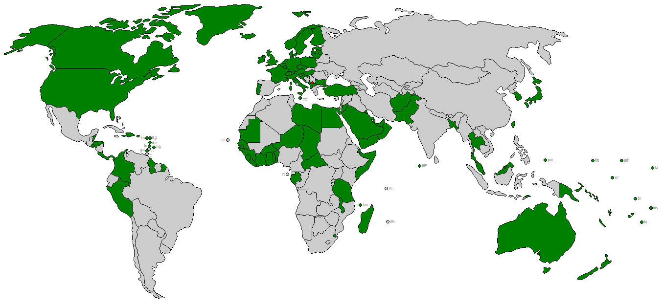
|
|
#
¿
Mar 18, 2014 01:12
|
|


|
Phlegmish posted:France is homogeneous outside of the cities in the sense that no one lives there. The ones that do are the ones that are diplomatically closest with the US. Mostly. I find it hilarious that Somalia is marked in green, when it has two autonomous areas that are not under government control at all.
|
|
#
¿
Mar 18, 2014 01:36
|
|
|
Phlegmish posted:They have an officially recognized government that is in control of a single Mogadishu neighborhood. I'm barely exaggerating. Yeah. In the past year there's been a big push in the press talking about how things in The government only survives with outside support and weapons. The US has been doing most of this (with cash or actual weapons shipments). So what little government they have is probably going to side with the US in abstract international policy that nobody in Somalia would care about anyway.
|
|
#
¿
Mar 18, 2014 01:58
|
|
|
duckmaster posted:Not particularly useful in a country which sent 8 MiG-21s to Israel a few years ago for upgrades. 4 of them mysteriously disappeared: almost certainly sold on by a senior air force General or government minister (probably a few of them). Cambodia has over 2200 Generals compared to the US cap of 500....! Jesus.  Do you have a source for those maps? I had no idea US involvement in Cambodia was so large, I thought it was very brief, or something. I guess I really don't know anything about it.
|
|
#
¿
Mar 19, 2014 20:46
|
|


|
AreWeDrunkYet posted:This article mentions the likely source, a released database of US bombing missions in the region Thanks. twoday posted:Thousands of years from now archeologists studying the 20th century will still be randomly blown up by XO, I would like to this. Consequently no one will want to study this period and our material culture will be poorly understood! Especially Belgian and Cambodian culture, "As previous cultures like the Egyptians sealed their dead deep beneath the Earth to prevent tomb-raiding, these other cultures have buried thousands of destructive traps to discourage theft. Even today, the traps can sometimes be deadly."
|
|
#
¿
Mar 20, 2014 16:14
|
|
|

|
| # ¿ May 13, 2024 02:25 |
|
|
DrSunshine posted:"Th-this place wasn't designed to keep people out... it was designed to keep something in!!" The Mongols sure did bring things together for China, didn't they? Sure they killed millions in the process, but break a few eggs, etc. Does the use of CE/BCE instead of AD/BC bug anyone else? I see no use to it, the established convention works just fine. If you're trying to be less Christian, well its a Christian calendar based on the life of its prophet so good luck.
|
|
#
¿
Mar 21, 2014 15:37
|
|

